 Arctic SDI catalogue
Marine Environment Monitoring
Type of resources
Available actions
Topics
Keywords
Contact for the resource
Provided by
Years
Formats
Representation types
Update frequencies
status
Service types
-
Debris Likelihood Index (Estimated) is calculated from GhostNet, NASA Aqua MODIS Chl a and NOAA GOES Imager SST data. THIS IS AN EXPERIMENTAL PRODUCT: intended strictly for scientific evaluation by professional marine scientists.
-
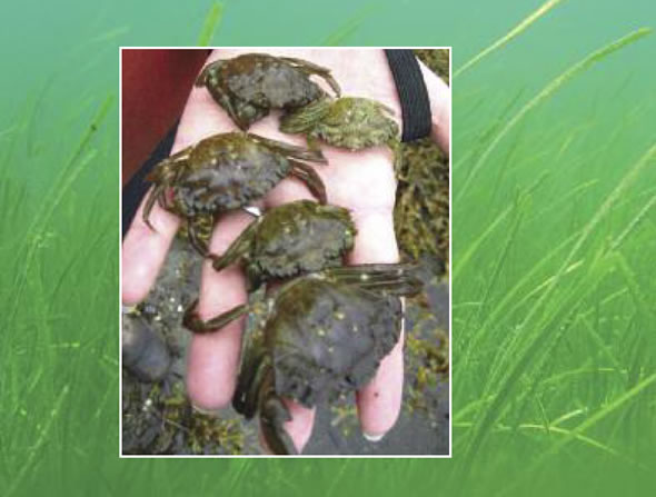
PURPOSE: Provide presence/absence and abundance data for the non-indigenous and invasive European green crab (EGC) in selected southern Gulf of St. Lawrence (sGSL) estuaries along the Northumberland Strait coast of New-Brunswick and eastern Prince-Edward-Island. DESCRIPTION: Temporal monitoring during ice-free seasons of European green crab abundance is completed in response to previous regional population declines in the Maritime provinces. Note that where presence is not indicated on the map does not mean absence - this survey is limited to a few sites. Traps that did not fish correctly were not included in the dataset. Examples of defective traps include: an open trap, an open bait container, a trap filled with algae and falling into the open position, a trap that has not been fished for over 48 hours, an overturned trap, or a trap that has been significantly moved or otherwise tampered with. Population estimates are not derived from this data. PARAMETERS COLLECTED: 1) EGC count, size measurement, sex, and catch weight 2) Counts of bycatch species. Categories reported in this dataset are finfish (cunner, striped bass, mummichog, winter flounder, smooth flounder, sculpin, tomcod, American eel, banded killifish, flounder, unknown bony fish), Atlantic rock crab, American lobster, and other (lion's mane jellyfish, moon jellyfish, other crabs, moon snail). Other smaller species were often in the trap but were not included as bycatch in this dataset as they can easily escape the mesh size and would not consistently be trapped. 3) Environmental data: water depth at trap setting, sediment type, vegetation types noted, salinity, water temperature, dissolved oxygen (not included), specific conductance (not included), conductivity (not included), weather, cloud cover (not included), tide state and direction (upon fishing). NOTES ON QUALITY CONTROL: Data entry of morphological parameters randomly verified for accuracy. Weights are not reported for PEI sites due to inconsistencies with types of weighing scales and measurement protocols. PHYSICAL SAMPLE DETAILS: Whole European green crab specimens SAMPLING METHODS: Baited trapping with Fukui traps. Bait was in a bait can or bag. Types of bait included herring (predominant type used), as well as other species when herring were not available (gaspereau, canned fish [tuna, kippers, snack sardines], mackerel, tilapia, and perch). USE LIMITATION: To ensure scientific integrity and appropriate use of the data, we would encourage you to contact the data custodian.
-
PURPOSE: To record hourly water temperatures throughout the Margaree watershed. DESCRIPTION: The Department of Fisheries and Oceans (DFO) has been deploying water temperature monitoring equipment since spring 1993 in the Margaree River watershed. Coverage has changed throughout the time series and there is little documentation regarding equipment used. In recent years data have been collected using VEMCOs. USE LIMITATION: To ensure scientific integrity and appropriate use of the data, we would encourage you to contact the data custodian.
-

PURPOSE: To gather localized high-quality data for mapping eelgrass distribution in bays and estuaries in the Gulf Region of Atlantic Canada. DESCRIPTION: Between 2018 and 2023, a total of 48 coastal sites in New Brunswick (NB), Prince Edward Island (PE), and Nova Scotia (NS) have been fully processed for eelgrass presence/absence and depth information. An additional 18 sites from the same region and time period (2018–2023) have data collected but not yet fully processed for depth and eelgrass classification. These sites will be incorporated into the dataset as processing is completed. PARAMETERS COLLECTED: Geographic coordinates, timestamp, submerged aquatic vegetation presence. NOTES ON QUALITY CONTROL: BioSonics Visual Aquatic was used to process raw dt4 files by delineating the bottom and submerged aquatic vegetation (SAV) heights. Initial delineation of the estuary bottom was performed using an automated algorithm within the software, followed by manual adjustments to refine the delineation as needed. An algorithm was then used to delineate vegetation, which was edited visually by referring to written ground-truthing notes and underwater photos taken with a GoPro underwater camera with GPS capacity. Expert advice within DFO was used to advise the analysts on best practices and subtleties in the echograms. All efforts were made to ensure vegetation mapped was eelgrass, but in some cases, such as where the acoustic response was not clear or ground-truthing notes were lacking, it is possible that other types of SAV were included. The processed data were exported from BioSonics Visual Aquatic aggregating sets of 10 pings that were in very close proximity. Grouped pings with a vegetation canopy height >= 0.1 m were assigned an eelgrass presence (i.e., "EG_Presence") value of "Y", while grouped pings with a height < 0.1 m were assigned a presence value of "N". SAMPLING METHODS: Acoustic data were collected during the summer or early fall season (varies depending on the site) by the Southern Gulf of St. Lawrence Coalition on Sustainability (Coalition-SGSL) in partnership with Fisheries and Oceans Canada (DFO) Gulf Region. At some sites, the Province of New Brunswick's Department of Agriculture, Aquaculture and Fisheries (NBDAAF) also collected data using their boat. BioSonics MX Aquatic Habitat Echosounder units with a single beam (8.7°) 204.8kHz transducer (mounting height varied depending on the boat used) was used for data collection by all parties. Positioning was achieved using the BioSonics internal GPS through 2020, then subsequently an external GPS unit (Hemisphere S631 RTK GPS) was used to improve positioning from 1-2m accuracy to ~20cm when differential was obtained. BioSonics Visual Acquisition software was used to collect the data. USE LIMITATION: This product is provided as-is and has not been accuracy-assessed against other data. Since there were no transect-independent ground-truthing points surveyed, the accuracy of any interpolated surfaces created from this data cannot be known. Not for use without inclusion of full metadata. The data products are supplied "as they stand" and DFO does not guarantee the integrity, the completeness, or the accuracy. There were issues with the internal GPS of the BioSonics unit, and their impact on positional accuracy has yet to be determined. Beginning in 2021, an external, higher precision GPS unit was used to increase accuracy. Use of various boats and surveyors, as well as analysts, can introduce some inconsistencies in the data collection and analysis between sites and years. Site-specific characteristics such as mixed submerged aquatic vegetation can complicate mapping efforts. Shallow areas can also be challenging to delineate accurately since the bottom and/or the vegetation can extend higher than the mounted transducer. In these cases, a best estimate was used by the analyst. Weather conditions such as wind can affect the accuracy of the results, as the transponder may pitch and roll with the boat, while increased sediment in the water can interfere with the signal. Single-beam acoustic data has a very small focus footprint, which varies with depth, so it should not be considered a comprehensive bottom mapping tool. However, it does provide valuable point data that can indicate presence of vegetation, canopy height, relative depth, and ground-truthing for other mapping techniques (e.g. aerial or satellite imagery). For example, at 1 m depth, the 8.6 degree single-beam used for this work has a footprint of approximately 0.0177 square metres, and at 2 m depth that footprint becomes 0.0711 square metres.
-
PURPOSE: Provide early detection of newly arrived Aquatic Invasive Species (AIS) and determine the spread, establishment and spatial distribution of existing AIS within marine waters of the southern Gulf of St. Lawrence (sGSL), DFO Gulf Region boundaries (northern and eastern coastal shores of NB, Gulf shore of NS, and PEI shoreline). DESCRIPTION: DFO Science monitors for AIS in the Gulf Region. The data collected from DFO's biofouling monitoring program provides an overview of the distribution and abundance of Aquatic Invasive Species (AIS) in the Gulf Region. This information can be used by the general public, scientists and DFO managers. Monitoring program targeting aquatic invasive species (AIS). Native biofouling species are not included in this dataset. Botrylloides violaceus: Violet tunicate Botryllus schlosseri: Golden star tunicate Ciona intestinalis: Vase tunicate Styela clava: Clubbed tunicate Caprella mutica*: Japanese skeleton shrimp Membranipora membranacea: Coffin box bryozoan Carcinus maenas*: European green crab Codium fragile*: Oyster thief alga Juxtacribrilina mutabilis**: Ribbed bryozoan (JCM) *indicates species that are not included as percent cover as they are not accurately captured by the sampling method, but are included as detections. **indicates species was only integrated fully into the monitoring protocol starting in 2025. Included here is a dataset of detection and percent cover data of AIS, as well as a monitoring station dataset. Environmental data collected, including from temperature loggers, are stored but not included here. PARAMETERS COLLECTED: Air and water temperature, salinity, depth, dissolved oxygen, weather conditions, list of biofouling AIS, percent cover of AIS on PVC plates, and incidental detection of other species and AIS in surrounding area. Only species data is pushed to the Open Data platform. NOTES ON QUALITY CONTROL: Each sample and species is processed and identified in a standardized fashion using standardized DFO Science AIS protocols and taxonomic references. Data is manually entered into DFO Gulf Region's AIS Science biofouling database and randomly verified for accuracy. SAMPLING METHODS: Biofouling monitoring is conducted using PVC collector plates that are deployed in the water column approximately 1 meter below the sea surface in the spring of each year. Biofouling organisms settle on these plates which are collected in the fall of the same year. Abundances of AIS are given as percent plate cover. Physico-chemical data including temperature, conductivity, and depth as well as weather conditions are noted at each geo-referenced biofouling monitoring site during initial deployment and at time of retrieval. All biofouling organisms settled on the underside of the PVC plates are noted and percent cover of each AIS is estimated. Any AIS present at the location is also noted. A HOBO temperature and light logger was deployed. USE LIMITATION: To ensure scientific integrity and appropriate use of the data, we would encourage you to contact the data custodian.