 Arctic SDI catalogue
Regional and National Core funds
Type of resources
Topics
Keywords
Contact for the resource
Provided by
Formats
Representation types
Update frequencies
status
-
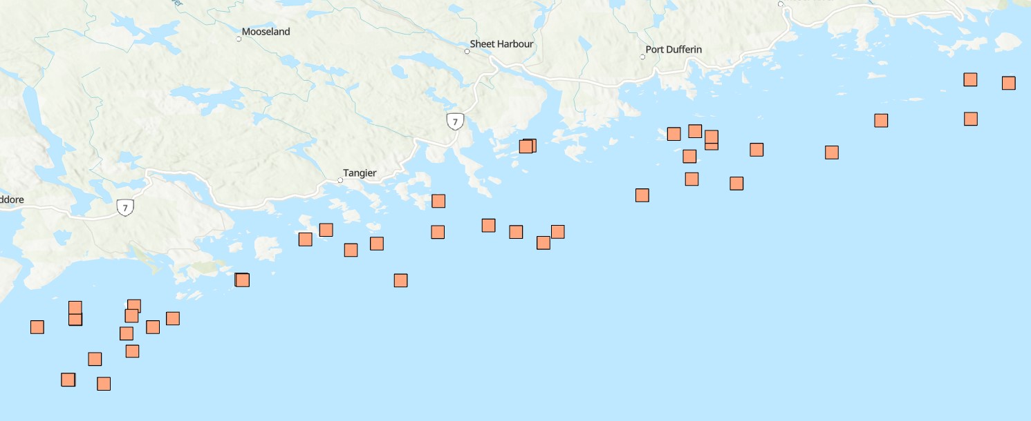
Funded under DFO's Marine Conservation Targets Program in partnership with the Huntsman Marine Science Centre (HMSC), this diver-based imagery and sample collection benthic survey documents the occurrence of sponges at 42 dive sites in the Eastern Shore Islands (ESI) Area of Interest (AOI, ~2089 km2) off the Atlantic coast of Nova Scotia, Canada from dive surveys conducted in summer 2021 and 2022. Water quality, species occurrences and counts, habitat, slope, and substrate characteristics were catalogued through diver log sheets, camera imagery, specimen vouchers, and high-resolution bathymetric data. A total of 54 dives to depths from 11 to 33 m (below sea level), collecting up to 147 still images, one-hour of video, and 17 specimen samples per site, resulted in 220 observations for 27 different sponge taxa. This included three new records for Canada (Hymedesmia stellifera, Plocamionida arndti, Hymedesmia jecusculum) and a range extension for a species new to science (Crellomima mehqisinpekonuta) which was recently described from the Bay of Fundy. There were also four species which may seem to be new to science (Halichondria sp., Hymedesmia sp., Protosuberires sp., and Sphaerotylus sp.). Sponges were found to occupy a diversity of micro-habitats, often several different ones in proximity. A total of eight distinct habitat classes were defined, based on varying abundances and diversity of sponges and associated benthic species. These are likely widely distributed among the many complex submerged seabed features within this AOI. Collected specimens were preserved and are stored at the Atlantic Reference Centre (ARC) in St. Andrew's, New Brunswick. Cite this data as: Goodwin, C., Cooper, J.A., Lawton, P., Teed, L.L. 2025. Sponge occurrence and associated species and habitat descriptions derived from the 2021 and 2022 SCUBA diving surveys in the Eastern Shore Islands Area of Interest, Nova Scotia. Version 1.4. Fisheries and Oceans Canada. Occurrence dataset. https://ipt.iobis.org/obiscanada/resource?r=eastern_shore_islands_sponge_survey_2021_2022&v=1.4
-

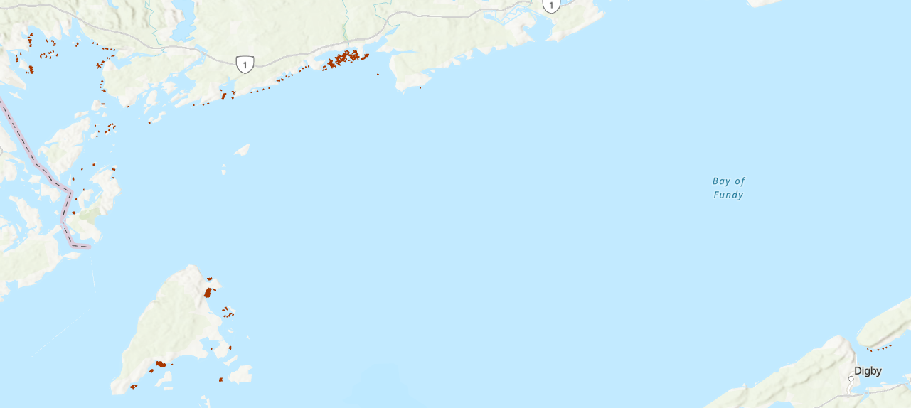
Funded under DFO's Marine Conservation Targets Program, this optical imagery benthic survey captured 73 drift-camera transects from September 21, 2022 to October 3, 2024 in the Fundy Isles region of the lower, western Bay of Fundy, New Brunswick, Canada. The survey area includes the 'Head Harbour/West Isles Archipelago/The Passages' Ecologically and Biologically Significant Area (ESBA, ~113 km2), the Wolves Islands and Grand Manan Island. High-resolution still images (n=5081) were taken periodically throughout each transect, while continuous high-definition downward- and forward-facing video (~30 hours of each) was collected simultaneously. Distance travelled and distance between still images (m) was calculated using ArcGIS tools. Field of view (FOV) was estimated by measuring the length and width of a subset of still images (n=863) in ImageJ2, using 10-cm lasers for scale. FOV was standardized for each reported altitude. Transects ranged from 133 m to 2.6 km in length (~47 km surveyed in total), collecting imagery continuously for 3 minutes to more than 1 hour at a time, surveying depths from 15 to 188 m below chart datum. Transect locations were selected based on unique bathymetric features, areas previously predicted to have high habitat suitability for vulnerable marine ecosystem species, as well as proposed areas for inclusion in the regional marine conservation network plan. Additional information and imagery pertaining specifically to the 2022 datasets can be found at the following link in the Open Government Portal: https://open.canada.ca/data/en/dataset/8ea6c28a-3d6c-47ef-8cf7-56790ee0c7f5 Cite this data as: Lawton P, Teed L. Near-seafloor drift transect video and high-resolution digital still imagery from a three-year survey in the Fundy Isles region of the lower, western Bay of Fundy. Published November 2025. Coastal Ecosystems Science Division, Fisheries and Oceans Canada, St. Andrews, N.B.
-
This dataset reports on lobster abundance and individual biological characteristics (size, sex, shell hardness, egg status), along with seabed substrate information, collected at various coastal sites in the Bay of Fundy, Canada. Surveys were conducted over a 40-year period between 1982 and 2021. Survey areas and SCUBA dive sites were located around Grand Manan Island, Deer Island, Campobello Island, and along the Bay of Fundy’s New Brunswick shore stretching from Passamaquoddy Bay, east to Maces Bay. One survey area was located on the Bay of Fundy’s southern shore (Nova Scotia) in the Annapolis Basin (Lawton et al. 1995). The data represent a compilation of SCUBA diving surveys (1003 belt transects) conducted directly by Fisheries and Oceans Canada (DFO) scientific SCUBA divers (1982-2019), or by contracted commercial divers funded in association with outside collaborating organizations; Department of Fisheries and Agriculture (DFA; 1990 – 1993), the Grand Manan Fishermen’s Association (GMFA; 2013-2015), and the University of New Brunswick (UNB; 2019-2021). Cite this data as: Lawton P, Dinning K, Rochette R, Teed L. American lobster (Homarus americanus) abundance and biological characteristics collected from SCUBA dive surveys in the Bay of Fundy from 1982-2021. Published August 2024. Coastal Ecosystems Science Division, Fisheries and Oceans Canada, St. Andrews, N.B. For additional information please see: Campbell, A. 1990. Aggregations of berried lobsters (Homarus americanus) in shallow waters off Grand Manan, eastern Canada. DFO Can. J. Fish. Aquat. Sci. 47: 520-523. Denton, C.M. 2020. Maritimes Region Inshore Lobster Trawl Survey Technical Description. DFO Can. Tech. Rep. Fish. Aquat. Sci. 3376: v + 52 p. Lawton, P. 1993. Salmon aquaculture and the traditional invertebrate fisheries of the Fundy Isles region: habitat mapping and impact definition: Cooperation Agreement on Fisheries and Aquaculture Development. Submitted by Peter Lawton to the New Brunswick Department of Fisheries and Aquaculture, 84 p. Unpublished monograph. Available from Fisheries and Oceans Canada Library, Dartmouth, NS (Monographs: SH 380.2 .C2 .L39 1992). https://science-catalogue.canada.ca/record=3943769~S6 Lawton, P., Robichaud, D.A., and Moisan, M. 1995. Characteristics of the Annapolis Basin, Nova Scotia, lobster fishery in relation to proposed marine aquaculture development. DFO Can. Tech. Rep. Fish. Aquat. Sci. 2035: iii + 26 p. Lawton, P., Robichaud, D.A., Rangeley, R.W., and Strong, M.B. 2001. American Lobster, Homarus americanus, population characteristics in the lower Bay of Fundy (Lobster Fishing Areas 36 and 38) based on fishery independent sampling. DFO Can. Sci. Advis. Sec. Res. Doc. 2001/093. Wentworth, C.K. 1922. A Scale of Grade and Class Terms for Clastic Sediments. The Journal of Geology 30(5): 377-392. Dinning, K.M., Lawton, P., and Rochette, R. 2025. Increased use of mud bottom by juvenile American lobsters (Homarus americanus) in Maces Bay and Seal Cove, Bay of Fundy, after three decades of population increases and predator declines. Canadian Journal of Fisheries & Aquatic Sciences 82; https://doi.org/10.1139/cjfas-2023-0312
-

A derivative of DFO's benthic imagery surveys for the Marine Conservation Targets Program in the St. Anns Bank Marine Protected Area (https://open.canada.ca/data/en/dataset/2a55e2b4-cbb6-4fea-b17e-a16f5e99e68f), occurrence records in this analysis represent presence/absence and density of a biogenic habitat-forming species in five drift-camera transects in the southeast corner of the MPA, off the coast of Cape Breton, Nova Scotia, Canada. Presence/absence and count data of the unstalked crinoid (Heliometra glacialis) were derived from the use of high-resolution Nikon D850 still images (n=428, see link to parent record for more descriptive survey information and complete imagery dataset) and continuous high-definition video observations (approximately one observation every second using a 1Cam Mk6, SubC Imaging camera; n=8522). Densities were estimated by dividing the crinoid counts by the field of view (calculated from lasers with 10-cm spacing). Substrates were reported for each video observation, documenting the dominant substrate (>50% cover) according to a modified Wentworth scale (i.e., sand, gravel, pebble, cobble, boulder, bedrock; Wentworth 1922). Crinoids were observed in ~44% of the area of the five transects (~4811 m2), forming dense beds along sloped features from 77-119-m depths, predominantly on cobble and pebble substrates, reaching densities of up to 59 ind. m-2 and 139 ind. m-2 in the digital still images and video observations, respectively. Cite this data as: Lawton P, Teed L. Fine-scale observations of high density Heliometra glacialis (Crinoidea) beds from five near-seafloor imagery transects from a two-year survey in the St. Anns Bank Marine Protected Area, Atlantic Canada. Published March 2026. Coastal Ecosystems Science Division, Fisheries and Oceans Canada, St. Andrews, N.B. References: - Wentworth, C.K. 1922. A scale of grade and class terms for clastic sediments. The Journal of Geology 30(5): 377-392.
-

A derivative of DFO’s benthic species survey for the Strategic Program for Ecosystem-based Research and Advice (SPERA) (open data record ID: e736c0f0-b19e-4842-903d-28bfc756d48a), this benthic survey funded through the Canadian Healthy Oceans Network (CHONeII) looks at the presence/absence and abundance of two biogenic habitat-forming species that are listed as vulnerable to disturbance in a subset of 50 drift camera transects in the ‘Head Harbour/West Isles Archipelago/The Passages’ Ecologically and Biologically Significant Area (EBSA) in the Bay of Fundy, New Brunswick, Canada (~113km2). Presence/absence and abundance data of the stalked sea squirt (Boltenia ovifera) and horse mussel (Modiolus modiolus) were derived from the use of high-resolution Nikon D800 36.1 megapixel still images (n=2576, see link to parent record for more descriptive survey information) to be used in species distribution modelling. Image field of view (FOV) was estimated using a 10 cm-wide trigger weight for scale,and standardized across images using the average FOV estimate (0.75 x 0.5 m) across a subset of 200 images. Species counts were then converted to abundance estimates (number of individuals per square-meter) by dividing counts by 0.375m2. Boltenia ovifera was observed at densities reaching 456 ind./m2, while Modiolus modiolus density reached a maximum of 240 ind./m2. Cite this data as: Mireault C.A., Lawton P., Devillers R. and Teed L. Presence/absence and abundance of vulnerable marine ecosystem species Boltenia ovifera and Modiolus modiolus in the lower Bay of Fundy derived from high resolution still imagery. Published September 2023. Coastal Ecosystems Science Division, Fisheries and Oceans Canada, St. Andrews, N.B. https://open.canada.ca/data/en/dataset/152ae3f1-d2b9-43d9-a7b4-d769d9e9fc41
-

Funded under DFO's Marine Conservation Targets Program, this two-year optical imagery benthic survey captured 41 drift-camera transects in the St. Anns Bank Marine Protected Area (MPA - 4364 km2) and 4 coastal transects west of the MPA, Atlantic Canada from August 15-23, 2023 and August 08-17, 2024. High-resolution still images (n=3605) were taken periodically throughout each transect, while continuous high-definition downward- and forward-facing video (~20 hours of each) was collected simultaneously along with over 14 hours of forward-facing Go-Pro video (only in 2024). Transect and image locations were collected using an acoustic positioning operating system (Kongsberg APOS) acquired in 2024; year-one of the survey relied on the vessel position. Distance travelled and distance between still images (m) was calculated using ArcGIS tools. Field of view (FOV) was estimated by measuring the length and width of a subset of still images from year-one of the survey (n=500) in ImageJ2, using 10-cm lasers for scale. FOV was standardized for each reported altitude. Transects ranged from 319 m to 2.8 km in length (~47 km surveyed in total), collecting imagery for 12 minutes to just over 1 hour at a time, surveying depths from 17 to 144 m below chart datum. Transect locations were selected based on unique bathymetric features and benthoscapes as well as areas previously surveyed from 2009-2015. Cite this data as: Lawton P, Teed L. Near-seafloor drift transect video imagery and high-resolution digital still images from a two-year survey in support of Marine Protected Area monitoring of St. Anns Bank, Atlantic Canada. Published January 2025. Coastal Ecosystems Science Division, Fisheries and Oceans Canada, St. Andrews, N.B.
-

Funded under DFO's Marine Conservation Targets Program, this optical imagery benthic survey documents the occurrence and estimated percent cover of the invasive colonial tunicate, Didemnum vexillum in seven drift-camera transects in the 'Head Harbour/West Isles Archipelago/The Passages' Ecologically and Biologically Significant Area (ESBA, ~113km2) in the western Bay of Fundy, New Brunswick, Canada. Occurrence data was derived from the use of high-resolution still images (n=386) taken periodically throughout each transect, and simultaneous continuous high-definition video. Video was divided into 20-second segments (here, we report the start and end location of each segment within a transect) and when D. vexillum was present in a video segment, frequency of occurrence was classified as common (continuous coverage/patches throughout the video segment), occasional (individual colonies of various sizes encountered >5 times throughout the video segment), or rare (small, isolated colonies encountered ≤5 times throughout the video segment). A video segment was deemed unusable and removed from the dataset if there was too much turbidity, or if the camera position was too high off-bottom to reliably image the seafloor. For still images, when D. vexillum was observed in an image, colony percent cover was categorized as >50%, 26-50%, 6-25%, or ≤5% of the images field of view (FOV). Distance travelled and distance between still images (m) was calculated using ArcGIS tools. FOV was estimated by measuring the length and width of a subset of still images and video frame grabs in ImageJ2, using 10-cm lasers for scale. FOV was standardized for each reported altitude, and area sampled (m2) along a continuous video segment was estimated by multiplying the average FOV by the distance travelled in that segment. D. vexillum was found in 44% of the area sampled at depths from 34 to 118m, deeper than previous reports globally of ~80m. Cite this data as: Teed LL, Goodwin C, Lawton P, Lacoursière-Roussel A, Dinning KM (2024) Multiple perspectives on the emergence of the invasive colonial tunicate Didemnum vexillum Kott, 2002 in the western Bay of Fundy, Atlantic Canada. BioInvasions Records 13(3): 713–738, https://doi.org/10.3391/bir.2024.13.3.12