 Arctic SDI catalogue
Surveillance
Type of resources
Topics
Keywords
Contact for the resource
Provided by
Years
Formats
Representation types
Update frequencies
status
Service types
-

The Eastern Shore Islands was announced as an "Area of Interest" (AOI) in 2018 by the DFO Maritimes region to potentially be considered for a Marine Protected Area under the federal Oceans Act. As part of its mandate for monitoring established and potential conservation areas, DFO Science regularly deploys instruments including conductivity/temperature/depth (CTD) loggers, and other instruments for measuring dissolved oxygen, nutrients, and other chemical ocean properties. This data collection includes temperature and other oceanographic records for the ESI AOI from June 2024 onward. The data are derived from temperature loggers (Hobo Tidbit loggers or similar) and Sea-Bird MicroCATs, but may in future years include current profiles or additional oceanographic data. These data will be used to monitor temperatures in this coastal region to detect any biological shifts associated with temperature and climate fluctuations, and be used to groundtruth oceanographic models. Cite this data as: Jeffery, N., Stanley, R., Pettitt- Wade, H. (2025): Data of: Baseline oceanographic records for the Eastern Shore Islands Area of Interest. Published: September 2025. Coastal Ecosystems Science Division, Fisheries and Oceans Canada, Dartmouth, N.S. https://open.canada.ca/data/en/dataset/f0020cec-5671-4908-8fdd-11fc097de99d
-
Long-term freshwater quality data from over 200 federal and federal-provincial sampling sites at various locations and sampling frequencies throughout Canada's aquatic ecosystems are included in this dataset. Measurements regularly include physical-chemical parameters such as temperature, pH, alkalinity, major ions, nutrients and metals. Collection includes data from active sites, as well as historical sites that have a period of record suitable for trend analysis. The number of sites in the network varies slightly from year-to-year, as sites are adjusted according to a risk-based adaptive management framework. The Great Lakes are sampled on a rotation basis and not all sites are sampled every year. Data are collected to meet federal commitments related to transboundary watersheds (rivers and lakes crossing international, inter-provincial and territorial borders) or under authorities such as the Department of the Environment Act, the Canada Water Act, the Canadian Environmental Protection Act, 1999, the Federal Sustainable Development Strategy, or to meet Canada's commitments under the 1969 Master Agreement on Apportionment./Les données de monitoring de la qualité de l'eau douce à long terme de plus de 200 sites d'échantillonnage fédéraux et fédéraux-provinciaux à diverses stations et fréquences d'échantillonnage à travers les écosystèmes aquatiques du Canada sont incluses dans cet ensemble de données. Les mesures incluent régulièrement les paramètres physico-chimiques tels que la température, le pH, l'alcalinité, les ions majeurs, les nutriments et les métaux. La collection inclut des données des sites actifs, ainsi que des sites historiques qui possèdent une période d'enregistrement propice à l'analyse des tendances. Le nombre de sites dans le réseau varie légèrement d'une année à l'autre, puisque les sites sont ajustés selon un cadre de travail de gestion adaptative basée sur le risque. Les Grands Lacs sont échantillonnés sur une base rotationnelle et tous les sites ne sont pas échantillonnés à chaque année. Les données sont recueillies afin de rencontrer les engagements fédéraux relatifs aux bassins versants transfrontaliers (rivières et lacs traversant des frontières internationales, interprovinciales et territoriales) ou sous certaines autorités telles que la Loi sur le ministère de l'Environnement, la Loi sur l'environnement, la Loi sur les ressources en eau du Canada, la Loi canadienne sur la protection de l'environnement de 1999, la stratégie fédérale de développement durable, ou pour rencontrer les engagements du Canada dans le cadre de l'Accord cadre sur la répartition des eaux des Prairies de 1969.
-
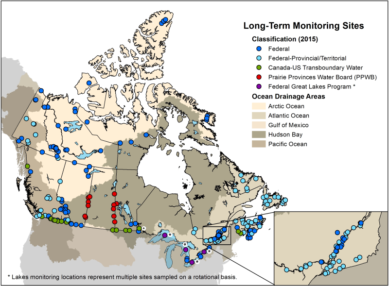
Long-term freshwater quality data from federal and federal-provincial sampling sites throughout Canada's aquatic ecosystems are included in this dataset. Measurements regularly include physical-chemical parameters such as temperature, pH, alkalinity, major ions, nutrients and metals. Collection includes data from active sites, as well as historical sites that have a period of record suitable for trend analysis. Sampling frequencies vary according to monitoring objectives. The number of sites in the network varies slightly from year-to-year, as sites are adjusted according to a risk-based adaptive management framework. The Great Lakes are sampled on a rotation basis and not all sites are sampled every year. Data are collected to meet federal commitments related to transboundary watersheds (rivers and lakes crossing international, inter-provincial and territorial borders) or under authorities such as the Department of the Environment Act, the Canada Water Act, the Canadian Environmental Protection Act, 1999, the Federal Sustainable Development Strategy, or to meet Canada's commitments under the 1969 Master Agreement on Apportionment.