 Arctic SDI catalogue
Nutrients
Type of resources
Available actions
Topics
Keywords
Contact for the resource
Provided by
Years
Formats
Representation types
Update frequencies
status
Service types
Scale
-

Ocean physical conditions in the Maritimes Region in 2019 were characterized by cooler surface temperatures, continued warmer bottom temperatures and weaker stratification compared to recent years. Deep nutrient inventories were lower than normal over most of the region, with the exception of the Cabot Strait section where deep nutrients were near or higher than normal during the spring sampling and associated with record-warm water. Anomalies of surface nutrients were negative across the region, with the exception of positive anomalies observed at the deep shelf and offshore stations of the Louisbourg section. The spring phytoplankton bloom was near or slightly earlier than normal across the Scotian Shelf (SS) with near-normal duration. Peak chlorophyll a concentrations during the spring bloom occurred within a narrow time window across the SS. At Halifax-2 (HL2), the spring bloom was characterized by a high amplitude, and a rapid progression and decline. Plankton community changes persisted in 2019 with lower abundance of large phytoplankton (diatoms), mainly lower-than-normal biomass of zooplankton and abundance of Calanus finmarchicus, and higher-than-normal abundance of non-copepods. Arctic Calanus and warm-shelf copepods showed mixed abundance anomalies in 2019, reversing the pattern of 2018. Above-normal abundances of Oithona atlantica, especially at HL2, suggest a greater influence of offshore waters in recent years. Surface temperature in the Bedford Basin was near normal in 2019 with mainly cooler-than-normal temperatures from January to June and near- or slightly-above-normal temperatures from July to December. Bottom temperature and salinity were below normal in 2019 with near- or slightly-above-normal conditions at the start of the year and progressing toward cooler and fresher water from February to December. Surface and deep nitrate, phosphate and silicate were near or below normal, with surface phosphate reaching a record low in 2019. The 2018 Continuous Plankton Recorder data indicated an annual abundance of diatoms close to normal for the Eastern (ESS) and Western Scotian Shelf (WSS), while the abundance of dinoflagellates and the Phytoplankton Colour Index values were near (WSS) or above (ESS) normal. The annual abundance of Calanus CI-IV was near normal (ESS) or slightly below normal (WSS), while C. finmarchicus CV-VI levels were slightly below (ESS) or below (WSS) normal. The abundance of Calanus glacialis (ESS, WSS) and Para/Pseudocalanus and Limacina spp. (WSS) were lower than normal, while that of coccolithphore (ESS, WSS), and copepod nauplii and foraminifera (ESS) was higher than normal. "
-
The Department of Fisheries and Oceans (DFO) holds discrete oceanographic, biological, and chemical data collected throughout the St. Lawrence Estuary, the Gulf of St. Lawrence, and the Saguenay Fjord, as well as data gathered outside of these zones during non-routine surveys (collected by the Quebec region). These data come from samples taken at different depths in the water column (surface, bottom, and intermediate depths), mainly during annual scientific missions such as: - weekly monitoring at fixed stations (Rimouski, Shediac Valley) - annual multispecies surveys (Northern and Southern Gulf) - spring and fall missions of the Atlantic Zone Monitoring Program This dataset presents the variables most frequently sampled for the period 1990 to two years prior to the present, namely, salinity, dissolved oxygen concentration, chlorophyll-a concentration, nutrient concentrations (nitrite, nitrate, silicate, phosphate), pH and alkalinity. These measurements are often accompanied by data from CTD profiles (Conductivity, Temperature, Depth/Pressure) and auxiliary sensors (fluorescence, turbidity, pH). Annual synthesis of the chemical and biological oceanographic conditions of the study area have been published since 2011, and reports on zonal conditions of the four Atlantic regions of DFO are also available for certain years: https://www.dfo-mpo.gc.ca/science/data-donnees/azmp-pmza/index-eng.html This record is updated annually as new data become available. To obtain access to earlier data, less frequently sampled variables, or specifications regarding laboratory analyses (analytical methods, preservation, and storage), please contact the data management team at: gddaiss-dmsaisb@dfo-mpo.gc.ca. Notes: This publication contains data extracted from the national BioChem database (Biological and Chemical Marine Data: DFO.BioChemDatabase-BasededonneesBioChem.MPO@DFO-MPO.GC.CA). When replicate samples were present, the values were averaged, and values were grouped by variable regardless of the analysis method, preservation method, or storage method. The grouping of variables collected at the same station is based on spatial and temporal metadata: LATITUDE, LONGITUDE, DATE, and TIME.
-
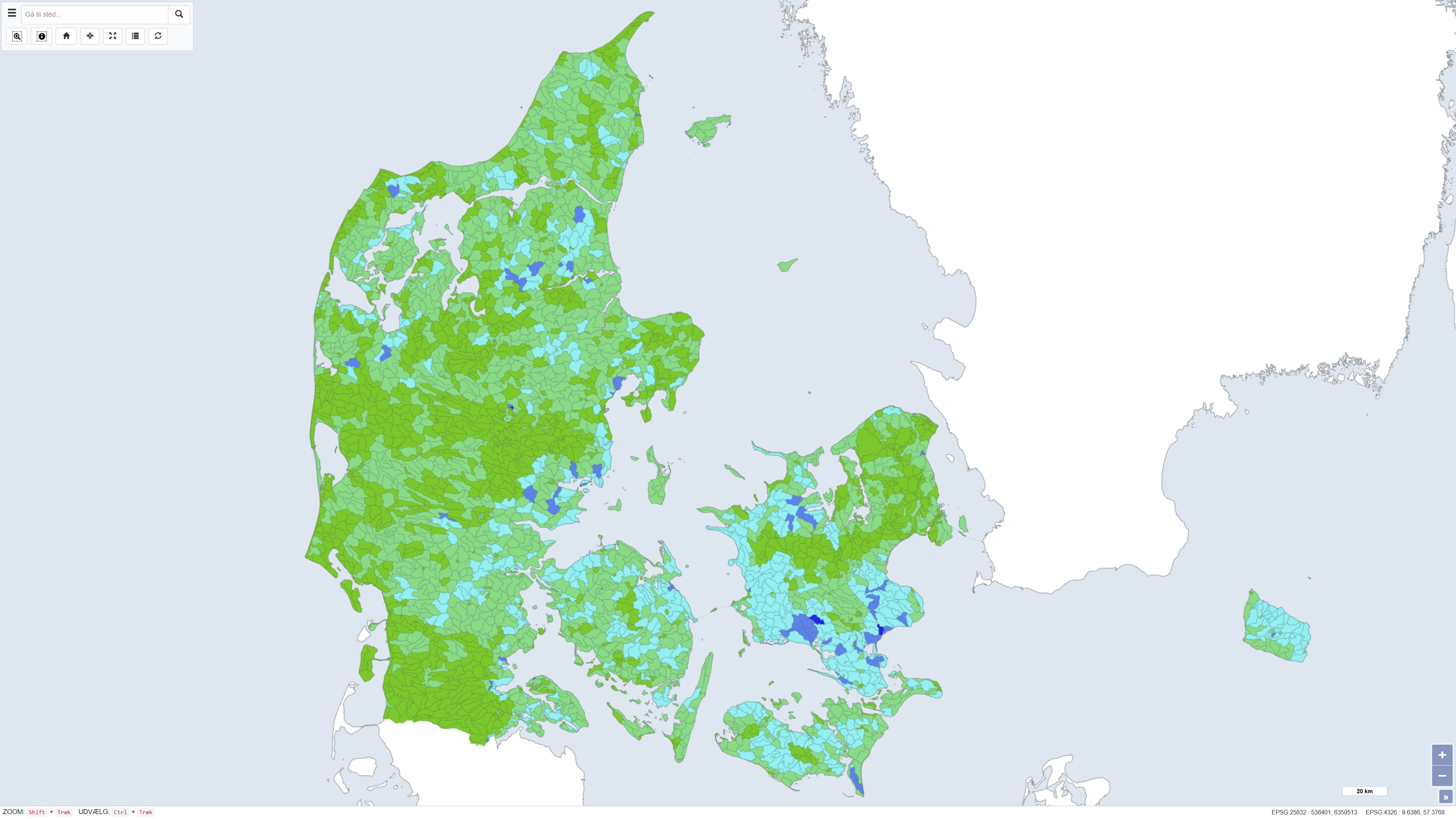
This dataset shows the percentage nitrogen retention in Denmark, i.e. the proportion of nitrogen leached from the root zone that is transformed or retained in the subsurface and surface waters before reaching the coast. Nitrogen retention is calculated using the National Nitrogen Model and represents an average retention for the period 1990–2010. The dataset provides nationwide coverage of spatial variations in nitrogen retention and is used as a basis for assessing nitrogen transport and coastal nutrient loading. The National Nitrogen Model version 2020 is documented in National Nitrogen Model – version 2020, a GEUS special report, including a method report (ISBN 978-87-7871-551-7) and an appendix (ISBN 978-87-7871-552-4), both available from GEUS (in danish).
-
Long-term freshwater quality data from over 200 federal and federal-provincial sampling sites at various locations and sampling frequencies throughout Canada's aquatic ecosystems are included in this dataset. Measurements regularly include physical-chemical parameters such as temperature, pH, alkalinity, major ions, nutrients and metals. Collection includes data from active sites, as well as historical sites that have a period of record suitable for trend analysis. The number of sites in the network varies slightly from year-to-year, as sites are adjusted according to a risk-based adaptive management framework. The Great Lakes are sampled on a rotation basis and not all sites are sampled every year. Data are collected to meet federal commitments related to transboundary watersheds (rivers and lakes crossing international, inter-provincial and territorial borders) or under authorities such as the Department of the Environment Act, the Canada Water Act, the Canadian Environmental Protection Act, 1999, the Federal Sustainable Development Strategy, or to meet Canada's commitments under the 1969 Master Agreement on Apportionment./Les données de monitoring de la qualité de l'eau douce à long terme de plus de 200 sites d'échantillonnage fédéraux et fédéraux-provinciaux à diverses stations et fréquences d'échantillonnage à travers les écosystèmes aquatiques du Canada sont incluses dans cet ensemble de données. Les mesures incluent régulièrement les paramètres physico-chimiques tels que la température, le pH, l'alcalinité, les ions majeurs, les nutriments et les métaux. La collection inclut des données des sites actifs, ainsi que des sites historiques qui possèdent une période d'enregistrement propice à l'analyse des tendances. Le nombre de sites dans le réseau varie légèrement d'une année à l'autre, puisque les sites sont ajustés selon un cadre de travail de gestion adaptative basée sur le risque. Les Grands Lacs sont échantillonnés sur une base rotationnelle et tous les sites ne sont pas échantillonnés à chaque année. Les données sont recueillies afin de rencontrer les engagements fédéraux relatifs aux bassins versants transfrontaliers (rivières et lacs traversant des frontières internationales, interprovinciales et territoriales) ou sous certaines autorités telles que la Loi sur le ministère de l'Environnement, la Loi sur l'environnement, la Loi sur les ressources en eau du Canada, la Loi canadienne sur la protection de l'environnement de 1999, la stratégie fédérale de développement durable, ou pour rencontrer les engagements du Canada dans le cadre de l'Accord cadre sur la répartition des eaux des Prairies de 1969.
-
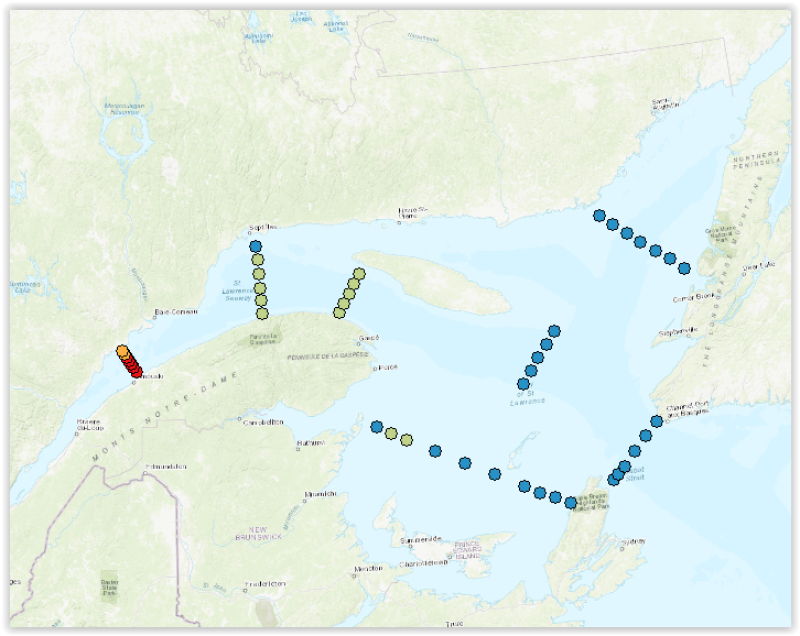
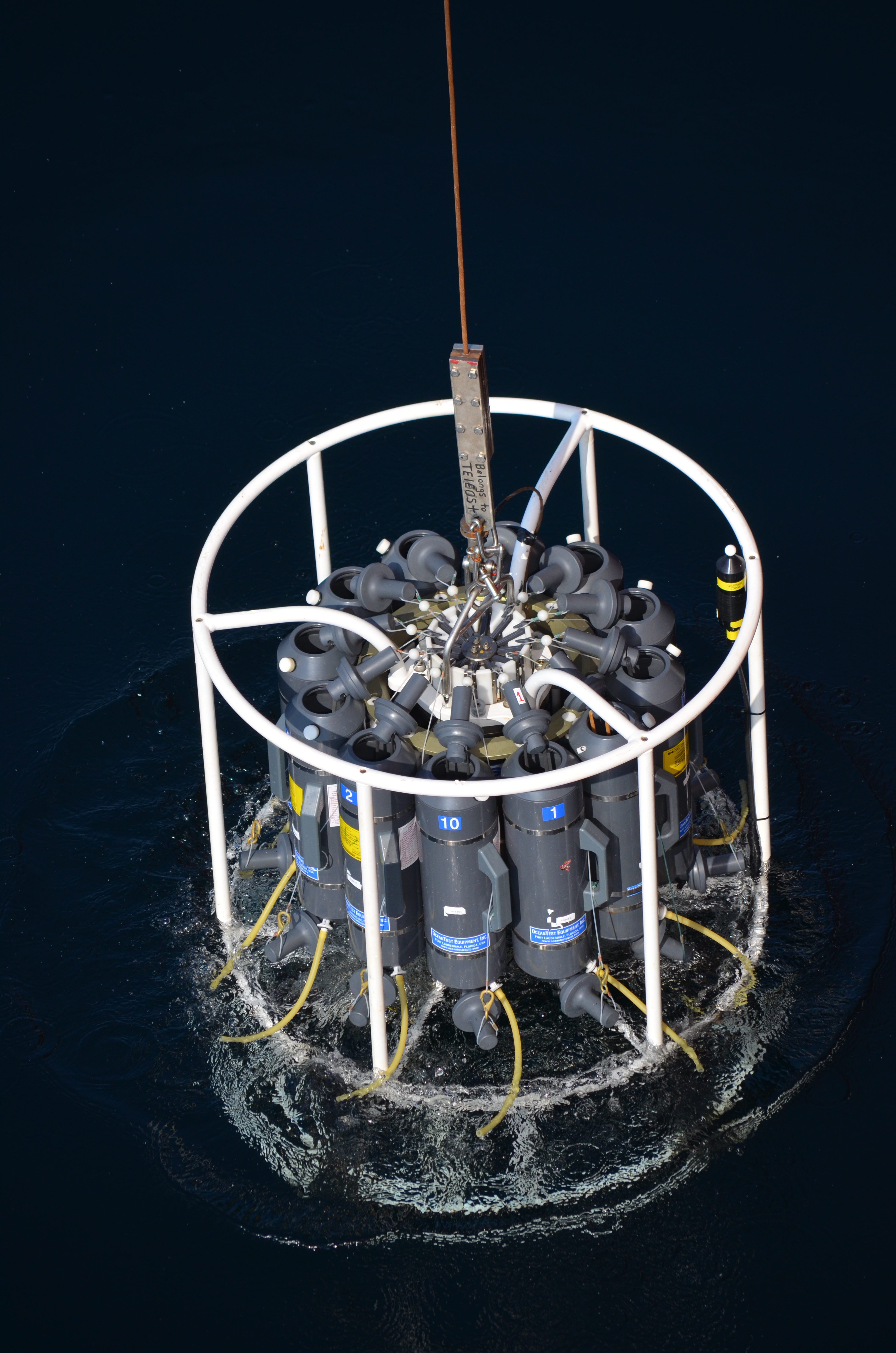
Time series of dissolved inorganic nutrients (nitrate, silicate, phosphate) (mmol/m2) at the 3 fixed stations and 46 stations, grouped into transects, of the Atlantic Zonal Monitoring Program (AZMP) under the Quebec region responsibility. The mean integrated nutrient data of 2 strata (0-50 m) et (50-150 m) from the last ten years are displayed as 12 layers, 6 for the June survey (2013-2022, 2020 not sampled) and 6 for the autumn survey (2013-2022). Finally, 2 other layers shows the positions of the fixed stations of the program (Anticosti Gyre, Gaspé Current and Rimouski). Each station is linked with a .png file showing the time series of nutrients and with a .csv file containing all the integrated nutrient data acquired at those stations since the beginning of the program sampling (columns : Station, Latitude, Longitude, Date(UTC), Sounding(m), Depth_min/Profondeur_min(m), Depth_max/Profondeur_max(m), Integrated_Nitrate/Nitrate_intégré(mmol/m²), Integrated_Phosphate/Phosphate_intégré(mmol/m²), Integrated_Silicate/Silice_intégrée(mmol/m²)). Purpose The Atlantic Zone Monitoring Program (AZMP) was implemented in 1998 with the aim of increasing the Department of Fisheries and Oceans Canada’s (DFO) capacity to detect, track and predict changes in the state and productivity of the marine environment. The AZMP collects data from a network of stations composed of high-frequency monitoring sites and cross-shelf sections in each following DFO region: Québec, Gulf, Maritimes and Newfoundland. The sampling design provides basic information on the natural variability in physical, chemical, and biological properties of the Northwest Atlantic continental shelf. Cross-shelf sections sampling provides detailed geographic information but is limited in a seasonal coverage while critically placed high-frequency monitoring sites complement the geography-based sampling by providing more detailed information on temporal changes in ecosystem properties. In Quebec region, two surveys (46 stations grouped into transects) are conducted every year, one in June and the other in autumn in the Estuary and Gulf of St. Lawrence. Historically, 3 fixed stations were sampled more frequently. One of these is the Rimouski station that still takes part of the program and is sampled about weekly throughout the summer and occasionally in the winter period. Annual reports (physical, biological and a Zonal Scientific Advice) are available from the Canadian Science Advisory Secretariat (CSAS), (http://www.dfo-mpo.gc.ca/csas-sccs/index-eng.htm). Devine, L., Scarratt, M., Plourde, S., Galbraith, P.S., Michaud, S., and Lehoux, C. 2017. Chemical and Biological Oceanographic Conditions in the Estuary and Gulf of St. Lawrence during 2015. DFO Can. Sci. Advis. Sec. Res. Doc. 2017/034. v + 48 pp. Supplemental Information Water sampling for nutrients analysis is done from Niskin bottles according to AZMP sampling protocol: Mitchell, M. R., Harrison, G., Pauley, K., Gagné, A., Maillet, G., and Strain, P. 2002. Atlantic Zonal Monitoring Program sampling protocol. Can. Tech. Rep. Hydrogr. Ocean Sci. 223: iv + 23 pp.
-
Ice and runoff samples collected and analysed during the RV Sanna GLICE cruise (August 2022)
-
Samples collected from an underway Towfish during RV Sanna cruise GLICE (August 2022) and either analysed at sea or returned preserved to GEOMAR for analysis. Sensor data refers to in-line data matching the underway samples.
-

This data layer presents the results of a modeling of net anthropogenic inputs of nitrogen and phosphorus (NANI/NAPI) carried out by Professor Roxane Maranger and Stéphanie Shousha from the University of Montreal as part of a partnership with the Ministry of the Environment, the Fight against Climate Change, Wildlife and Parks (MELCCFP). The modeling was carried out using the Net Anthropogenic Nitrogen/Phosphorus Input method applied for the first time in Quebec by ([Goyette et al., 2016]) (https://can01.safelinks.protection.outlook.com/?url=https%3A%2F%2Fagupubs.onlinelibrary.wiley.com%2Fdoi%2F10.1002%2F2016GB005384&data=05%7C02%7CAntoine.Prince%40environnement.gouv.qc.ca%7Ce9a3e849691c4a3f9bc008de4e23f624%7C4262d4ec5a674957abb6bf78aca6a6f5%7C0%7C0%7C639034113587157844%7CUnknown%7CTWFpbGZsb3d8eyJFbXB0eU1hcGkiOnRydWUsIlYiOiIwLjAuMDAwMCIsIlAiOiJXaW4zMiIsIkFOIjoiTWFpbCIsIldUIjoyfQ%3D%3D%7C 0% 7C%7C%7C&sdata=a7ktxc6ea9u4thdsbor9ojrkspdjgwno%2Fbaizkkkuaq%3D&reserved=0)) then refined in ([Shousha & Maranger, 2024] (https://can01.safelinks.protection.outlook.com/?url=https%3A%2F%2Fbesjournals.onlinelibrary.wiley.com%2Fdoi%2Ffull%2F10.1111%2F1365-2664.14733&data=05%7C02%7CAntoine.Prince%40environnement.gouv.qc.ca%7Ce9a3e849691c4a3f9bc008de4e23f624%7C4262d4ec5a674957abb6bf78aca6a6f5%7C0%7C0%7C639034113587193473%7CUnknown%7CTWFpbGZsb3d8eyJFbXB0eU1hcGkiOnRydWUsIlYiOiIwLjAuMDAwMCIsIlAiOiJXaW4zMiIsIkFOIjoiTWFpbCIsIldUIjoyfQ%3D%3D%7C0%7C%7C%7C&sdata=AdT31R8 IHMEEYRZZ1HGMTRTUAEE8XMRMAQBRNAUJDN 4% 3D&reserved=0)). The model is based on the premise that a region imports nitrogen and phosphorus to support its population and agricultural activities.**This third party metadata element was translated using an automated translation tool (Amazon Translate).**
-
Basic biogeochemical parameters obtained from the GLICE cruise in Disko Bay (August 2022), either analyzed at sea or preserved and returned to GEOMAR for analysis.
-

Phytoplankton species abundance (cell/L) and oceanographic conditions (temperature, salinity, chlorophylle-a (mg/m³) for some years and nutrient content (mmol/m³)) at stations of the Harmful Algae Monitoring Programme (HAMP) from1994 to 2016. The layer presents the station positions of the HAMP. Two files are attached to each station: one containing the cell counts and the second the oceanographic conditions. Purpose The summer growth of many toxic and harmful microalgae species poses a serious threat for the public health and commercial or recreational exploitation of some marine species. The Department of Fisheries and Oceans (DFO) initiated the Harmful Algae Monitoring Programme (HAMP) in 1989 in order to complete the monitoring program for paralytic shellfish poisoning (PSP). Under the responsibility of Maurice-Lamontagne Institute scientists, the HAMP is to monitor, by means of a coastal station network, the natural occurrence of toxic and harmful algae in the St. Lawrence in order to determine their spatio-temporal distribution and the environmental conditions leading to their bloom. The network is made up of 11 coastal stations which are sampled every week from April to November and which are established along Quebec eastern shores. It extends from Tadoussac to Tête-à-la-Baleine on the St. Lawrence north shore and from Sainte-Flavie to Carleton on the south shore along the Gaspé peninsula. Another station is located in Havre-Aux-Maisons, Magdalen Islands. The HAMP was discontinued in 2010 but opportunistic samplings are still done at some stations. Additional information The sampling and analysis protocol is described in details in the following publication apart from the fact that the number of identified and counted species significantly has been increasing with time. Phytoplankton samples are preserved in a lugol solution. Blasco D., M. Levasseur, R. Gélinas, R. Larocque, A.D. Cembella, B. Huppertz et E. Bonneau.1998. Monitorage du phytoplancton toxique et des toxines de type IPM dans les mollusques du Saint-Laurent: 1989 à 1994. Rapp. stat. can. hydrogr. sci. océan. 15 1 : x i-117 p.