 Arctic SDI catalogue
géologie
Type of resources
Available actions
Topics
Keywords
Contact for the resource
Provided by
Formats
Representation types
Update frequencies
status
Scale
-

An interpretation of bedrock geology, topography and other sources of information that shows the potential for karst formations. This is a reconnaissance level map for all of British Columbia
-
A polygon coverage showing the location of coalfields with coalbed methane (cbm) potential in BC
-

This layer contains polygon features that represent geological units in New Brunswick. The associated Bedrock Geology Relate Table contains details about each map unit, including: a brief legend description, Group name, Formation name, and rock age. This layer is the result of nearly 50 years of bedrock mapping and it continues to change as new interpretations are made and more data is collected through field work and analysis.
-
This layer contains polygon features that represent the generalized surficial geology of New Brunswick. Unconsolidated materials occurring over bedrock, are classified according to physical attributes and genesis, and categorized into map units. This layer is intended to be used at small scales (e.g., provincial scale). It is an update of the 2002 Generalized Surficial Geology Map of New Brunswick, the updates reflect re-interpretation of the geology based on additional field investigations.
-
This layer contains polygon features that represent geological units in New Brunswick. The associated Bedrock Geology Relate Table contains details about each map unit, including: a brief legend description, Group name, Formation name, and rock age. This layer is the result of nearly 50 years of bedrock mapping and it continues to change as new interpretations are made and more data is collected through field work and analysis.
-

The Yukon Territory is underlain by a great variety of rock types ranging in age from Early Proterozoic to Recent and representing diverse environments including epicratonic basins, subsiding shelves, foreland basins, island arcs and deep ocean basins. Episodes of compressional and extensional deformation, transcurrent faulting, metamorphism and plutonism further complicate the map pattern. This complex geological record has been described in terms of the interactions of several terranes (large parts of the earth's crust which preserve a common geological record) with each other and with the margin of ancestral North America. Distributed from [GeoYukon](https://yukon.ca/geoyukon) by the [Government of Yukon](https://yukon.ca/maps) . Discover more digital map data and interactive maps from Yukon's digital map data collection. For more information: [geomatics.help@yukon.ca](mailto:geomatics.help@yukon.ca)
-
Grouping can include up to a maximum of 750 placer claims. All placer claims must be contiguous, i.e. they must be adjoining. Any solitary placer claims that do not share at least one boundary with the placer claims to be grouped cannot be included in the grouping. Distributed from [GeoYukon](https://yukon.ca/geoyukon) by the [Government of Yukon](https://yukon.ca/maps) . Discover more digital map data and interactive maps from Yukon's digital map data collection. For more information: [geomatics.help@yukon.ca](mailto:geomatics.help@yukon.ca)
-
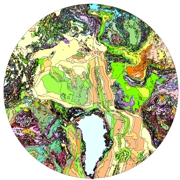
As part of the International Polar Year (IPY) 2007'08 and 2008'09 activities, and related objectives of the Commission for the Geological Map of the World (CGMW), nations of the circumpolar Arctic have co-operated to produce a new bedrock geology map and related digital map database at a scale of 1:5 000 000. The map, released in north polar stereographic projection using the World Geodetic System (WGS) 84 datum, includes complete geological and physiographic coverage of all onshore and offshore bedrock areas north of latitude 60° north.
-

This map service provides access to the Chronology dataset shown on the GeoAtlas application. **Please Note – All published Saskatchewan Geological Survey datasets, including those available through the Saskatchewan Mining and Petroleum GeoAtlas, are sourced from the Enterprise GIS Data Warehouse. They are therefore identical and share the same refresh schedule. This dataset represents the chronology for the Province of Saskatchewan at 1:1 million scale. It is a regional distribution of bedrock categorized by age into Archean, Archean or Proterozoic, Proterozoic, Helikian, Ordovician, Silurian, Devonian, Cretaceous, and Tertiary for the province of Saskatchewan, Canada. Mapping in support of this dataset was over many years of compiling bedrock data and integrating into this product. The data was created as a file geodatabase feature class and output for public distribution.