 Arctic SDI catalogue
5000000
Type of resources
Available actions
Topics
Keywords
Contact for the resource
Provided by
Years
Formats
Representation types
Update frequencies
status
Scale
-
Gagnasafn (GDB) NI_reit_v_LiflandfraedilegSvaedi_sveppir: Líflandfræðileg svæði fyrir sveppi [Bio-geographical provinces for fungi in Iceland]. Reitakerfið er notað til að sýna grófa útbreiðslu sveppa eftir landshlutum og byggir á 10 km reitakerfi NÍ. Fláka- og línulag.
-

Hydrogeological Regions provide a framework to introduce the regional hydrogeology of Canada and to connect apparently disparate studies into a broader framework. The hydrological regions are first order areas used to capture and summarize data that will help develop more detailed profiles of each region. Comparison of findings within and between regions will allow scalable extension to sub-regional and watershed scale mapping. Canada has been classified into nine principal hydrogeological regions. Each region is described briefly based on the following five hydrogeological characteristics (Heath, 1984): system components and geometry; water-bearing openings; rock matrix composition; storage and transmission; recharge/ discharge. The hydrogeological classification emphasizes major geological provinces and rock formations. Fundamental water-bearing openings and rock matrix properties help determine the quantity (storage), flux (transmission), and composition of formation waters. These same properties and any overlying sediment cover affect recharge/ discharge rates for regional formations. While regional attributes are general, a simple aquifer mapping scheme can further describe the nature and character of aquifers in each region. For example, general groundwater settings across the country could be described as has been done by USGS principal aquifers [1]. Thus the regional framework can potentially link from national scales to watershed scales by identifying typical aquifer types based on readily available geological maps that use water-bearing character as a common attribute. The nine hydrogeological regions include: Cordillera Mountains with thin sediment over fractured sedimentary, igneous and metamorphic rocks of Precambrian to Cenozoic age. Intermontane valleys are underlain by glacial and alluvial deposits of Pleistocene age. Plains (Western Sedimentary Basin) Region-wide basin of sub-horizontal Paleozoic to Cenozoic sedimentary rocks are overlain by thick glacial deposits filling buried valleys. Incised post-glacial valleys provide local relief. Shallow gas, coal, and brines may occur. Canadian Shield Undulating region of thin glacial sediment overlying complex deformed, fractured PreCambrian igneous, metamorphic and sedimentary rocks. Region contains several terrains: sedimentary basins, structural belts, and glacial-lacustrine basins. Hudson Bay (Moose River) Basin Sedimentary basin of Paleozoic to Mesozoic sub horizontal carbonate and clastic sediment covered by surficial deposits, with low relief and poor drainage. Southern Ontario Eastern Great Lakes region is underlain by gently-dipping Paleozoic, carbonate, clastic and gypsum-salt strata overlain by glacial sediments up to 200 m thick with tunnel valleys. Karst, bedrock valleys, shallow gas and brines are also important components. St. Lawrence Lowlands Lowlands underlain by shallow-dipping Paleozoic sedimentary rocks and thick glacial sediment in glacial-marine basins. Appalachian and Precambrian uplands discharge water to valleys. Shallow gas and saltwater intrusion are possible. Appalachia Upland to mountainous region with thin surficial sediment on folded Paleozoic sedimentary and igneous rocks. Range of rock types yields a wide range of water compositions. Valleys contain important alluvial aquifers. Maritimes Basin Lowlands with flat-lying, Carboniferous clastic , salt, and gypsum rocks contain shallow coal deposits. Surface glacial sediment is thin and discontinuous. Salt water intrusion is possible. Permafrost Arctic islands and most areas north of 60o contain frozen ground affects on groundwater flow. Diverse topography and geology define sub-regions of sedimentary basins and crystalline rocks. Glacial sediment is thin, discontinuous; local peat accumulations are significant.
-
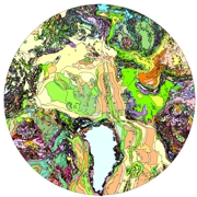
As part of the International Polar Year (IPY) 2007'08 and 2008'09 activities, and related objectives of the Commission for the Geological Map of the World (CGMW), nations of the circumpolar Arctic have co-operated to produce a new bedrock geology map and related digital map database at a scale of 1:5 000 000. The map, released in north polar stereographic projection using the World Geodetic System (WGS) 84 datum, includes complete geological and physiographic coverage of all onshore and offshore bedrock areas north of latitude 60° north.
-

The map displays bedrock formations at or near the surface of the land, on the sea floor above the continental crust that forms the Canadian landmass, and oceanic crust surrounding the landmass. The bedrock units are grouped and coloured according to geological age and composition. The colours of offshore units and oceanic crust are paler and more generalized than those on land, although the constituent units offshore are still easily discernible from their dashed boundaries. This colour design, coupled with the use of a white buffer zone at the coast allows the coastline of Canada to be readily distinguished and still show the grand geological architecture of the Canadian landmass. The map also shows major faults that have disrupted the Earth's crust, onshore and offshore, and a variety of special geological features such as kimberlite pipes, which locally contain diamonds, impact structures suspected to have been caused by meteorites, and extinct and active spreading centres in the surrounding oceans.
-

The map identifies surficial materials and associated landforms left by the retreat of the last glaciers and non glacial environments. The surficial geology is based on compilation of existing maps. This work provides new geological knowledge and improves our understanding ofthe distribution, nature and glacial history of surficial materials. It contributes to resource assessments and effective land use management. This new surficial geology map product represents the conversion of the map "Surficial Materials of Canada" (Fulton, 1995) and its legend, using the Geological Survey of Canada's Surficial Data Model (SDM version 2.0) which can be found in Open File 7631 (Deblonde et al.,2014). All geoscience knowledge and information from map 1880A that conformed to the current SDM were maintained during the conversion process. However, only terrestrial units are depicted on this map. Map units below modern sea level or major lake levels are not shown but are maintained in the digital data of this publication. Where additional information was required in certain regions of the Arctic and Cordillera, legacy geology map data were used. These maps are listed in the digital "Map Information" document. All other source maps used in map 1880A are not relisted here. The purpose of converting legacy map data to a common science language and common legend is to enable and facilitate the efficient digital compilation, interpretation, management and dissemination of geologic map information in a structured and consistent manner. This provides an effective knowledge management tool designed around a geo-database which can expand following the type of information to appear on new surficial geology maps.
-
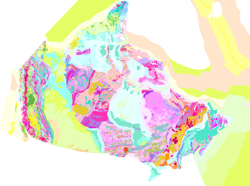
The map displays bedrock formations at or near the surface of the land, on the sea floor above the continental crust that forms the Canadian landmass, and oceanic crust surrounding the landmass. The bedrock units are grouped and coloured according to geological age and composition. The colours of offshore units and oceanic crust are paler and more generalized than those on land, although the constituent units offshore are still easily discernible from their dashed boundaries. This colour design, coupled with the use of a white buffer zone at the coast allows the coastline of Canada to be readily distinguished and still show the grand geological architecture of the Canadian landmass. The map also shows major faults that have disrupted the Earth's crust, onshore and offshore, and a variety of special geological features such as kimberlite pipes, which locally contain diamonds, impact structures suspected to have been caused by meteorites, and extinct and active spreading centres in the surrounding oceans.