 Arctic SDI catalogue
KML
Type of resources
Available actions
Topics
Keywords
Contact for the resource
Provided by
Years
Formats
Representation types
Update frequencies
status
Scale
Resolution
-

This is a Mosaic of Canada which is made from 121 images captured by Canadian satellite RADARSAT-2. These images were acquired from May 1, 2013 to June 1, 2013. The color variation represents the changes in soil texture, roughness and the level of soil moisture. (Credit: RADARSAT-2 Data and Products © MacDonald, Dettwiler and Associates Ltd. (2013) - All Rights Reserved. RADARSAT is an official mark of the Canadian Space Agency.)
-
This data provides the integrated cadastral framework for Canada Lands. The cadastral framework consists of active and superseded cadastral parcel, roads, easements, administrative areas, active lines, points and annotations. The cadastral lines form the boundaries of the parcels. COGO attributes are associated to the lines and depict the adjusted framework of the cadastral fabric. The cadastral annotations consist of lot numbers, block numbers, township numbers, etc. The cadastral framework is compiled from Canada Lands Survey Records (CLSR), registration plans (RS) and location sketches (LS) archived in the Canada Lands Survey Records.
-
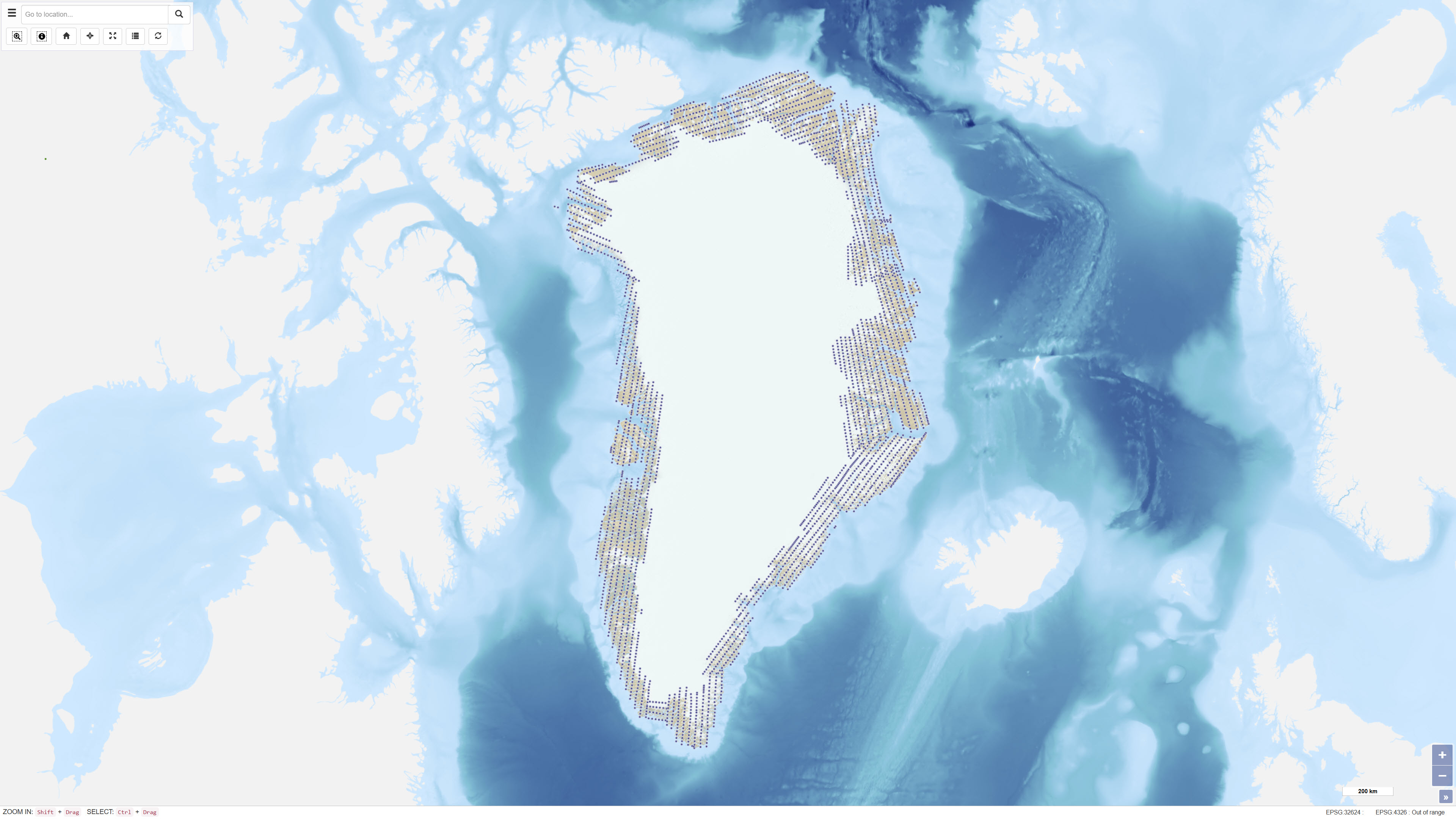
Uniform vertical aerial photographic coverage of Greenland was achieved between 1978 and 1987 at a scale of 1:150.000 by Mark Hurd Aerial Surveys, Inc., Minneapolis, Minnesota, U.S.A., on behalf of the Danish Geodetic Institute. The photography provided systematic nationwide coverage and formed a fundamental reference dataset for mapping and geodetic purposes. The black-and-white photographs were acquired using a Wild RC-10 camera equipped with a super wide-angle lens (focal length 88 mm). The aircraft used was a Gates Learjet 25C, flying at approximately 14 km altitude to achieve the image scale of 1:150.000. To minimise blind areas caused by steep mountain slopes in combination with the wide-angle lens, photographs were acquired with 80% forward overlap and 40% side overlap. Photo centre coordinates were established through aerotriangulation performed by the Danish Geodata Agency. The dataset has subsequently been used for mapping, aerotriangulation and scanning applications.
-

Used within the Travellers Road Information Portal Interactive Map to convey transportation related information in both official languages. This information includes a list of locations of carpool parking lots near dozens of highway interchanges throughout Ontario. This data is best viewed using Google Earth or similar Keyhole Markup Language (KML) compatible software. For instructions on how to use Google Earth, read the [Google Earth tutorial](http://www.google.com/earth/index.html) **.** This data set is now available via the Ontario 511 Developer API at *[KML]: Keyhole Markup Language This data is related to: * This data set is now available via the [Ontario 511 Developer API](https://511on.ca/developers/doc)
-
Used within the Travellers Road Information Portal Interactive Map to convey transportation related information in both official languages. Contains a list of ferry service locations operated by the Ministry of Transportation within Ontario. This data is best viewed using Google Earth or similar Keyhole Markup Language (KML) compatible software. For instructions on how to use Google Earth, read the [Google Earth tutorial](http://www.google.com/earth/index.html) **.** This data set is now available via the Ontario 511 Developer API at *[KML]: Keyhole Markup Language
-
This date set contains up-to date information regarding current and future roadwork occuring on provicnally owned and maintained highways, and is available to be viewed on [Ontario 511](https://511on.ca) under the "construction and roadwork" layer. This data set can also be viewed on the Ontario 511 text report page at https://511on.ca/list/roadwork.
-
This data set contains up-to date information regarding ongoing construction projects on provincially owned and maintained highways, and is available to be viewed on [Ontario 511](https://511on.ca) under the "construction and roadwork" layer. This data set can also be viewed on the Ontario 511 text report page at https://511on.ca/list/constructionprojects
-
High-Occupancy Vehicle (HOV) lanes are designated lanes that can only be used by vehicles carrying two or more people or other specifc types of vehicles, such as licensed taxis and motorcycles. For more information regarding HOV lanes, please visit [HOV](https://www.ontario.ca/page/high-occupancy-vehicle-hov-lanes). HOV lanes can also be viewed on a map, by visiting [Ontario 511](https://511on.ca), and can be found under the "service" layer.
-
This date set contains up-to date information regarding current and future roadwork occuring on provicnally owned and maintained highways, and is available to be viewed on [Ontario 511](https://511on.ca) under the "construction and roadwork" layer. This data set can also be viewed on the Ontario 511 text report page at https://511on.ca/list/roadwork.
-
Used within the Travellers Road Information Portal Interactive Map to convey transportation related information in both official languages. Contains a list of the 23 service centres managed by the Ministry of Transportation along Highway 401 from Windsor to the Quebec border, and along a portion of Highway 400 north of Toronto. This data is best viewed using Google Earth or similar Keyhole Markup Language (KML) compatible software. For instructions on how to use Google Earth, read the [Google Earth tutorial](http://www.google.com/earth/index.html) **.** This dataset is now available via the [Ontario 511 Developer API](https://511on.ca/developers/doc) *[KML]: Keyhole Markup Language