 Arctic SDI catalogue
surface water
Type of resources
Available actions
Topics
Keywords
Contact for the resource
Provided by
Formats
Representation types
Update frequencies
status
Scale
-

The province of PEI has been monitoring dissolved oxygen in some Island estuaries since 2015.
-
The province of PEI has been monitoring dissolved oxygen in some Island estuaries since 2015.
-

These datasets include information on Licences under the Water Act collected by Alberta Environment and Protected Areas, for both active and inactive authorizations for surface water and groundwater diversions under a Licence (defined as a “diversion of water” under the Water Act).
-

**PLEASE NOTE:** The Environmental Monitoring System will be replaced by the EnMoDS system on March 5th, 2026. The EMS results objects will not contain new data after Feb 26th, 2026. For recent data please refer to [EnMoDS spatial locations and location groups](https://catalogue.data.gov.bc.ca/dataset/f60fa4b5-e3d0-44ad-b5d8-778d29764e34). Environmental monitoring stations (EMS) points coverage for the Province by MONITORING LOCATION GROUPS.
-
**PLEASE NOTE:** The Environmental Monitoring System will be replaced by the EnMoDS system on March 5th, 2026. The EMS results objects will not contain new data after Feb 26th, 2026. For recent data please refer to [EnMoDS spatial locations and location groups](https://catalogue.data.gov.bc.ca/dataset/f60fa4b5-e3d0-44ad-b5d8-778d29764e34). Environmental Monitoring Stations (EMS) spatial points coverage for the Province by LOCATION TYPES. The following spatial layers reference this as a data source: 1. Environmental Monitoring - All Stations 2. Environmental Monitoring Stations - Air Monitoring (Ambient Air Site) 3. Environmental Monitoring Stations - Air Monitoring (Air Permit) 4. Environmental Monitoring Stations - Water Sites (Water Monitoring) 5. Environmental Monitoring Stations - Water Sites (Water Permits) 6. Environmental Monitoring Stations - Water Sites (Well) 7. Environmental Monitoring Stations - Water Sites (Observation Well) 8. Environmental Monitoring Stations - Water Sites (Spring)
-

PURPOSE: This study is part of a two-decade series of research aimed to provide a comprehensive synthesis of the effects of harvest and environmental change on fisheries in Great Bear Lake. The main objectives are to assess demographic traits and the current status of harvested species, with a focus on evaluating sustainable harvest levels of lake trout, a cold-adapted species with a relatively narrow thermal niche. As part of this research, trends in water quality are monitored to evaluate potential effects of change on fisheries. DESCRIPTION: Great Bear Lake, one of the largest lakes in North America, contains culturally and recreationally important fish species. Great Bear Lake is located in the sub-Arctic and Arctic Circle. As part of a two-decade series of research aimed to provide a comprehensive synthesis of the effects of harvest and environmental change on fisheries in Great Bear Lake, the main objectives of this study are to assess demographic traits and the current status of harvested species, with a focus on evaluating sustainable harvest levels of lake trout, a cold-adapted species with a relatively narrow thermal niche. As part of this research, trends in water quality are monitored to evaluate potential effects of change on fisheries. From 2000 to 2011, surface water temperature data was collected at depths of approximately 0.1 to 1.0 meters using a handheld digital thermometer through partnered community-led and community/Fisheries and Oceans Canada/ university partners collaborative sampling. The project has strong community involvement, including youth through the Guardian Program, to facilitate capacity building and community leadership in the long-term monitoring of Great Bear Lake fisheries and the aquatic ecosystem. This data is the beginning in a series of baseline data sets on water quality from this lake. These data will contribute to a better understanding of cumulative impacts of climate change on the functioning of large northern lake ecosystems, and provide a benchmark for monitoring further change. This data will be important for developing effective strategies for maintaining community-led aquatic monitoring and managing natural resources, particularly fish, which are expected to be increasingly important to communities with declines in other country foods such as caribou. We acknowledge the data were collected in the Sahtú Settlement Area and are made publicly available with the agreement of the Délı̨nę Renewable Resources Council (Délı̨nę Ɂehdzo Got’ı̨nę (Renewable Resources Council)). Collaborators include: the Community of Délı̨nę partners (data collection), Délı̨nę Renewable Resource Council, Sahtú Renewable Resource Board, Great Lakes Fisheries Commission, and University of Alberta. Community of Délı̨nę partners and field workers that participated in data collection include Jane Baptiste, Doug Baton, Moise Beyonnie, Gloria Gaudette, Bruce Kenny, Greg Kenny, Hughie Kenny, Jonas Kenny, Morris Lennie, George Menacho, Morris Modeste, Nathan Modeste, Isreal Neyelle, Lyle Neyelle, Clyde Takazo, Lucy Ann Takazo, Freddie Vital, Cameron Yukon, Cyre Yukon, Tyrone Yukon, Charity Yukon, Chris Yukon, Archie Vital, John Betsidea, and Barbara Yukon. Funding and logistical support was provided by: Northwest Territories Cumulative Impact Monitoring, Sahtú Renewable Resource Board, the Polar Continental Shelf Program, Canadian Circumpolar Institute, Natural Sciences and Engineering Research Council of Canada, Government of Northwest Territories Renewable Resources Délı̨nę, and Fisheries and Oceans Canada.
-
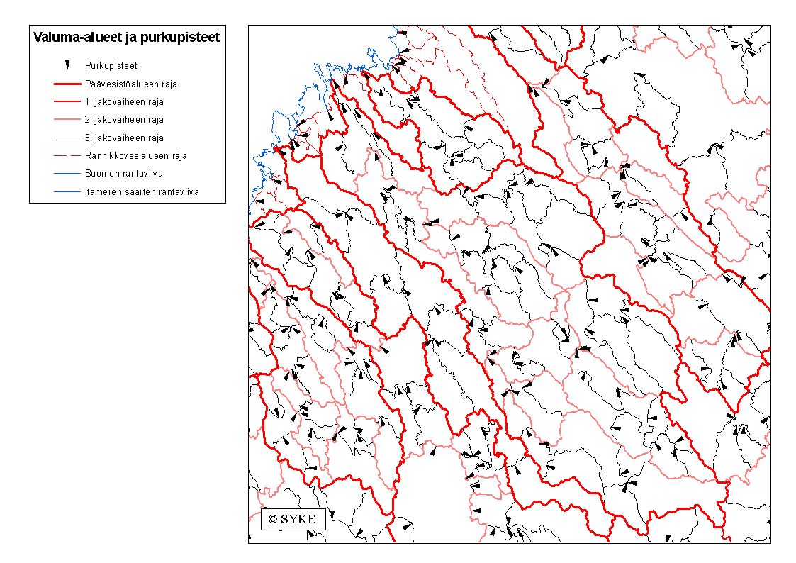
1990-luvun alussa valmistunut aineisto sisältää Suomen päävesistöalueet, valuma-aluejaon sekä purkupisteet. Valuma-alueet on rajattu topografian ja vesistöjen perusteella 1:50 000 mittakaavaisille paperikartoille, joilta alueet on digitoitu FINGIS-ohjelmalla sokkodigitointina. Hierarkkinen valuma-aluejako sisältää enimmillään 3, joista tarkimmassa jakovaiheessa on yhteensä yli 5 600 osa-aluetta. Valuma-aluejaon hierarkisuutta voidaan kuvata käyttämällä aineistoon liittyviä valuma-alueiden reunaviivoja sekä valuma-aluetunnusta. Päävesistöalueita on 74 kappaletta, niiden pinta-ala on yli 200 km2 ja numerointi alkaa Laatokkaan laskevista vesistöalueista ja kiertää rannikkoalueet myötäpäivään päättyen Vienan mereen laskeviin vesistöihin. Yli 10 000 km2:n kokoisten päävesistöalueiden osajaossa aina kolmanteen jakovaiheeseen asti on käsiteltävä alue jaettu enintään 9 osa-alueeseen, jolloin yhdellä vesistöalueella on enintään 729 osa-aluetta. Kooltaan 1 000-10 000 km2 suuruiset päävesistöalueet on jaettu kahteen jakovaiheeseen, jolloin osa-alueita on vesistöalueella enintään 81 kappaletta. Alle 1 000 km2 suuruiset päävesistöalueet on jaettu enimmillään yhdeksään osa-alueeseen.Aineisto kuuluu SYKEn avoimiin aineistoihin (CC BY 4.0). Käyttötarkoitus: Valuma-aluejako on tehty pääasiassa hydrologisen seurannan tarkoituksiin. Purkupisteet voivat sijaita sivu-uoman tai järven luusuan lisäksi myös esimerkiksi voimalan tai muun hydrologisen mittauspaikan kohdalla. Valuma-alueiden koko voi vaihdella huomattavasti (n.2 km2- n.3500 km2) johtuen valitusta tunnusjärjestelmästä sekä Suomen luonnonmaantieteellisistä erityispiirteistä (mm. järviset alueet) Vesipolitiikan puitedirektiivin vesienhoidon suunnittelujärjestelmä perustuu valuma-alueajattelulle, mm. direktiivin mukaiset vesienhoitoalueet on muodostettu päävesistöalueista. Lisätietoja: https://geoportal.ymparisto.fi/meta/julkinen/dokumentit/valuma-aluejako.pdf 2020-luvulla on laadittu ensimmäinen kokonaan digitaalisilla tuotantomenetelmillä toteutettu mallinnukseen perustuva Suomen kattava hierarkkinen valuma-aluejako, joka tulee korvaamaan 1990-luvulla käyttöönotetun valuma-aluejaon. Suomen ympäristökeskuksen (Syke) laatima valtakunnallinen valuma-aluejako koostuu viidestä hierarkiatasosta, jotka kattavat uomien ja järvien valuma-alueiden lisäksi myös merialueet. Tarkimmalla tasolla valuma-aluejaossa on yli 40 000 valuma-aluetta. https://ckan.ymparisto.fi/dataset/valuma-aluejako Catchment Areas In the early 1990s completed spatial dataset of Finnish catchment areas includes main river basins, river basins’ delineation and discharge points. The catchment areas were delinated on the basis of topography on 1:50,000 scale paper maps, from which the catchment areas were digitized with the FINGIS program as blind digitization. The hierarchical river basin /delineation has 3 levels. In the most precise level there are over 5,600 sub-areas. The structure of the hierarchy is described using catchment area boundaries together with the river basin codes attached to the features. The database has 74 main river basins with an area over 200 km². The code numbering starts from the south-eastern river basins flowing to the Lake Ladoga, and continues clockwise along the Baltic coast, ending to the rivers flowing into the Arctic Ocean and the White Sea. All the river basin hierarchy levels have maximum 9 sub-basins. Besides the main river basins, the boundaries are determined for 177 small coastal basins, smaller than 200 km²; they are not further divided into sub-basins. This Syke’s dataset can be used according to open data license (CC BY 4.0). INSPIRE compatible dataset has been published. In the 2020s completed spatial dataset of Finnish catchment areas based on modeling implemented entirely with digital production methods made by the Finnish Environment Institute (Syke) consists of five hierarchical levels, which cover not only the catchment areas of river segments and lakes, but also sea areas. At the most precise level, there are more than 40,000 catchment areas in the river basin system. https://ckan.ymparisto.fi/dataset/valuma-aluejako