 Arctic SDI catalogue
wintering
Type of resources
Available actions
Topics
Keywords
Contact for the resource
Provided by
Formats
Representation types
Update frequencies
status
-

Forested areas managed to provide severe winter habitat for herds of white tail deer on Crown lands.
-
Forested areas managed to provide winter habitat for herds of white tail deer on Crown lands.
-
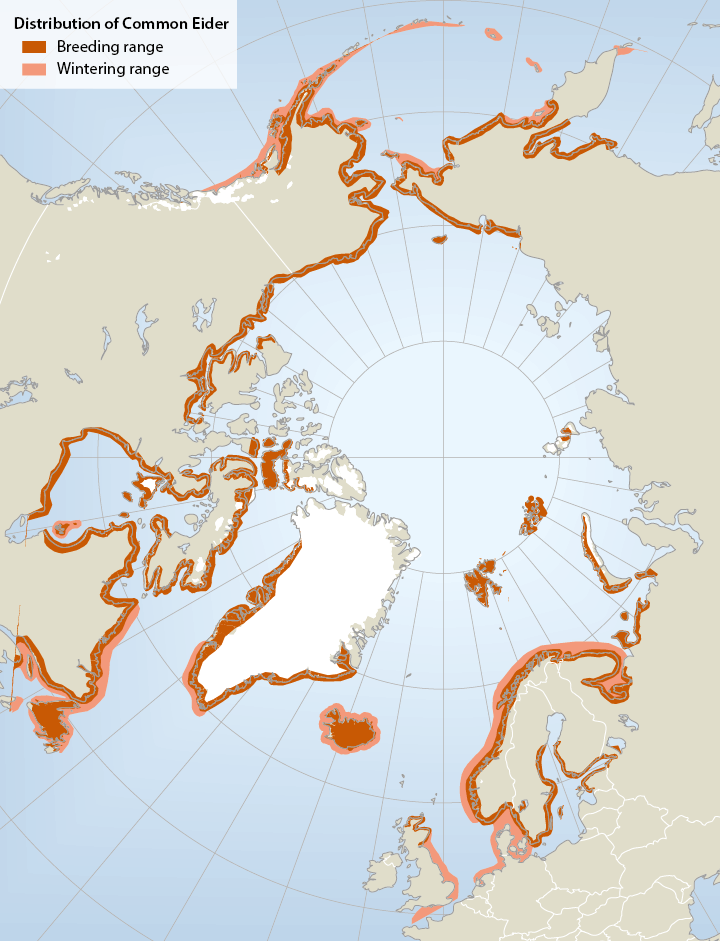
Breeding and wintering range of common eiders Somateria mollissima in the circumpolar region (not all southern breeding areas included).The common eider Somateria mollissima has a circumpolar distribution breeding mainly on small islands in Arctic and boreal marine areas in Alaska (Bering Sea region), Canada, Greenland, Iceland, N Europe and the Barents Sea region. In mainland Russia, there is a gap in distribution from the Yugorski Peninsula (Kara Sea) to Chaunskaya Bay in E Siberia Important wintering areas include the Gulf of Alaska/Bering Sea/Aleutian region, SE Canada, SW Greenland, Iceland and NW Europe. Six or seven subspecies are recognized, of which four occur in North America. - <a href="http://arcticbiodiversity.is/the-report/chapters/birds" target="_blank">Arctic Biodiversity Assessment. Status and Trends in Arctic biodiversity. - Birds(Chapter 4) page 150</a>
-

The wildlife values area and site datasets represent the consolidation of 13 wildlife data classes collected by the Ministry of Natural Resources. The data estimates locations used by wildlife for various reasons, including: * breeding * calving and fawning * denning * feeding * staging * nesting * wintering * general habitat areas * nurseries * travel corridors Locations are represented as points (site) or polygons (area) and may be related to a specific species or described more generally. Wildlife values data is most often used to support policy and legislation associated with the Crown Forest Sustainability Act. The data may also be used to inform a wide range of resource management activities and decisions. There are additional sensitive features related to provincially tracked species and species at risk that are not available as part of the open data package. Sensitive features are subject to licensing and approvals and may be requested by contacting [geospatial@ontario.ca](geospatial@ontario.ca).
-
The wildlife values area and site datasets represent the consolidation of 13 wildlife data classes collected by the Ministry of Natural Resources. The data estimates locations used by wildlife for various reasons, including: * breeding * calving and fawning * denning * feeding * staging * nesting * wintering * general habitat areas * nurseries * travel corridors Locations are represented as points (site) or polygons (area) and may be related to a specific species or described more generally. Wildlife values data is most often used to support policy and legislation associated with the Crown Forest Sustainability Act. The data may also be used to inform a wide range of resource management activities and decisions. There are additional sensitive features related to provincially tracked species and species at risk that are not available as part of the open data package. Sensitive features are subject to licensing and approvals and may be requested by contacting [geospatial@ontario.ca](geospatial@ontario.ca).