 Arctic SDI catalogue
breeding
Type of resources
Available actions
Topics
Keywords
Contact for the resource
Provided by
Years
Formats
Representation types
Update frequencies
status
Service types
-
Tjenesten viser estimerte bestander for sjøfugl per årstid. Tallene henviser til estimerte bestander pr. 10x10 km2 rute.
-
Tjenesten viser estimerte hekkebestander for sjøfugl
-
Arctic Biodiversity Assessment (ABA) 2013. Figure 4.2. Major flyways of Arctic birds. Bird migration links Arctic breeding areas to all other parts of the globe (adapted from ACIA 2005). Conservation of Arctic Flora and Fauna, CAFF 2013 - Akureyri . Arctic Biodiversity Assessment. Status and Trends in Arctic biodiversity. - Birds(Chapter 4) page 146
-
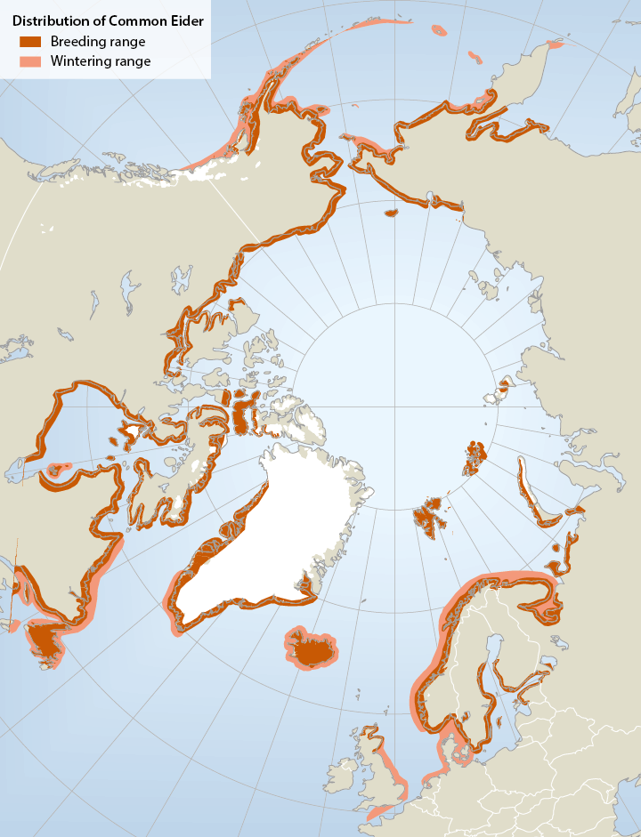
Breeding and wintering range of common eiders Somateria mollissima in the circumpolar region (not all southern breeding areas included).The common eider Somateria mollissima has a circumpolar distribution breeding mainly on small islands in Arctic and boreal marine areas in Alaska (Bering Sea region), Canada, Greenland, Iceland, N Europe and the Barents Sea region. In mainland Russia, there is a gap in distribution from the Yugorski Peninsula (Kara Sea) to Chaunskaya Bay in E Siberia Important wintering areas include the Gulf of Alaska/Bering Sea/Aleutian region, SE Canada, SW Greenland, Iceland and NW Europe. Six or seven subspecies are recognized, of which four occur in North America. - <a href="http://arcticbiodiversity.is/the-report/chapters/birds" target="_blank">Arctic Biodiversity Assessment. Status and Trends in Arctic biodiversity. - Birds(Chapter 4) page 150</a>
-

Distribution of Alcid habitat in coastal British Columbia showing relative abundance (RA) by season and overall relative importance (RI). RI is based on project region and not on the province as a whole. CRIMS is a legacy dataset of BC coastal resource data that was acquired in a systematic and synoptic manner from 1979 and was intermittently updated throughout the years. Resource information was collected in nine study areas using a peer-reviewed provincial Resource Information Standards Committee consisting of DFO Fishery Officers, First Nations, and other subject matter experts. There are currently no plans to update this legacy data.
-
Great Slave Lake in the Northwest Territories is one of the most important areas for inland breeding gulls and terns (larids) in northern Canada. Numerous rocky islands on the North Arm provide breeding habitat for a number of colonially-nesting larid species. Great Slave Lake is the only known breeding site for Caspian Terns in the Northwest Territories and the North Arm is the northernmost known breeding range for the species in North America. Given its importance to a variety of migrating, nesting and staging birds, various portions of the area have been recognized as; a Key Migratory Bird Terrestrial Habitat site, an Important Bird Area, and an International Biological Program site. This dataset contains results from surveys of active larid breeding colonies from between 1986 and 2010 on the portion of the North Arm west of Yellowknife. Most data were collected through ground surveys, with travel by boat, between mid June to early July. Information recorded at each colony included species, numbers of nests, clutch size, presence of chicks, and habitat characteristics (vegetation cover). The majority of larid colonies were located on islands along the northeastern shoreline. The southwest shoreline saw limited use by nesting larids due to the reduced number and different characteristics of the islands in that area. The most regularly occurring species were Herring Gull, Mew Gull, Ring-billed Gull, California Gull, Common Tern, Arctic Tern, and Caspian Tern. Results of these surveys have been published in the report “Gull and Tern Breeding Colonies on the North Arm of Great Slave Lake, Northwest Territories: 1986-2010 (Woodard, Fournier, and Robertson, 2013). Woodard, P.F., M.A. Fournier, and M.O. Wiebe Robertson. 2013. Gull and Tern Breeding Colonies on the North Arm of Great Slave Lake, Northwest Territories: 1986-2010. Technical Report Series No. 526, Canadian Wildlife Service, Yellowknife, NT. More details are available in the metadata document for download. CWS-North DatasetID: 071_0
-

The wildlife values area and site datasets represent the consolidation of 13 wildlife data classes collected by the Ministry of Natural Resources. The data estimates locations used by wildlife for various reasons, including: * breeding * calving and fawning * denning * feeding * staging * nesting * wintering * general habitat areas * nurseries * travel corridors Locations are represented as points (site) or polygons (area) and may be related to a specific species or described more generally. Wildlife values data is most often used to support policy and legislation associated with the Crown Forest Sustainability Act. The data may also be used to inform a wide range of resource management activities and decisions. There are additional sensitive features related to provincially tracked species and species at risk that are not available as part of the open data package. Sensitive features are subject to licensing and approvals and may be requested by contacting [geospatial@ontario.ca](geospatial@ontario.ca).
-
Arctic Program for Regional and International Shorebird Monitoring (Arctic PRISM) Tier 1 survey data
The Program for Regional and International Monitoring (PRISM) was designed by biologists and researchers from the Canadian and United States Governments (Canadian Wildlife Service, U.S. Geological Survey and U.S. Fish and Wildlife Service) to address concerns about shorebird population declines first noted on migration surveys. To set population targets and understand the conservation and management concerns needed to conserve and recover shorebird populations we needed to first know how many shorebirds are actually present. Previous to Arctic PRISM, population size estimates for non-harvested species came from expert opinion supported by migration counts, where birds are dispersed widely and length of stay issues made converting counts to population size difficult, or from localized or aerial surveys on the non-breeding grounds where again, only a subset of the widely-dispersed, and continuously moving on a large-scale, birds could be surveyed. Next, we needed to know population trends, and their severity. To address these crucial information gaps, PRISM consists of four survey components: (1) Arctic breeding, (2) Migration, (3) Neotropical and (4) Tropical surveys. Although all four survey components have been initiated, the Arctic breeding survey component -- Arctic PRISM -- is the furthest into the design and implementation. The goals of the broader PRISM are to: 1. Estimate population size. 2. Monitor trends in population size. 3. Monitor shorebirds at stopover locations. 4. Determine distribution, abundance, and habitats utilized throughout the year. 5. Assist local managers in meeting shorebird conservation goals. Arctic PRISM is designed to address all of the broader PRISM goals except Goal 3. Arctic PRISM is comprised of three Tiers. Tier 1 is North American arctic-wide surveys conducted at a large number of sites to get statistically rigorous (unbiased), survey-based, species-specific population estimates for Arctic-breeding shorebirds (PRISM Goal 1). These surveys are referred to as the ‘rapid surveys’ as the methodology is to visit a plot (relatively) quickly and infrequently and cover a large survey study area (PRISM Goal 4). The Tier 1 surveys are conducted in Rounds to calculate population trends (PRISM Goal 2) and changes in distribution over time (PRISM Goal 4). There is a U.S. Fish and Wildlife Service and US Geological Survey mirror to these surveys covering the Alaskan portion of the North American arctic. Tier 2 is ‘intensive surveys’ at a smaller number of non-random sites located in areas with known concentrations of shorebirds. The repeated, in-depth data collected at these long-term study sites provides annual information on the breeding biology of shorebirds that cannot be captured during the Tier 1 surveys, and provides a shorter-term assessment of site-specific population trends (PRISM Goal 2). At these sites are also where we monitor shorebird demographics and investigate potential causes of population declines. Tier 3 uses the Northwest Territories-Nunavut Bird Checklist Program (now with eBird) to non-systematically track changes in shorebird abundance and distribution across the Canadian Arctic (PRISM Goal 4). All three Tiers of Arctic PRISM are being used to inform conservation management (PRISM Goal 5) through use of the data in environmental assessment, species at risk (assessment, critical habitat), and protected areas (designation, monitoring) processes. While Arctic PRISM was originally designed with shorebirds in mind, early in the implementation we discovered the methodology would result in population size and trend estimates for nearly all of the non-colonial arctic-breeding birds. This dataset is contains the bird and habitat data collected as part of Arctic PRISM using the rapid survey methodology (and adjacent methodologies: non-systematic area search methodology and spaghetti transects methodology; primarily as part of Arctic PRISM Tier1) in the Canadian arctic (Yukon, Northwest Territories, Nunavut, Nunavik) from 1994 to the annotated data release cut-off. TIER1: RAPID SURVEY, NON-SYSTEMATIC AREA SEARCH AND SPAGHETTI TRANSECT METHODOLOGY We divided the Canadian arctic into strata comprised of region, subregion and GIS-derived habitat type. Within each stratum, a random sample of all available plots was selected to be surveyed (rapid surveys (methodology) of rapid plots (plot type). Plots were typically 300m x 400m or 400m x 400min size. Plots were surveyed during courtship through early incubation by observers walking systematically through the plot quickly on foot and recording all species present, and also completing an assessment of the habitat from a ground perspective. Similar survey methodologies (‘non-systematic area search’ (methodology) and ‘spaghetti transect’ (methodology)) were conducted in a less systematic method than the standard rapid survey (methodology) on plots of various sizes, typically reconnaissance plots (plot type) to help inform future rapid surveys (methodology) of rapid plots (plot type). Rapid surveys (methodology) were also done on intensive plots (plot type). These intensive plots (plot type) are non-randomly selected where birds are known to be breeding, and to capture a variety of species. Intensive surveys (method) of intensive plots (plot type), and other associated methodologies related to Arctic PRISM Tier 2, are not included in this dataset. For the detailed methodology used in Arctic PRISM, see Smith et al. 2025 or Bart and Johnston (eds) 2012. Smith, Paul A., Jonathan Bart, Victoria H. Johnston, Yves Aubry, Stephen C. Brown, Charles M. Francis, R. I. Guy Morrison, Lisa D. Pirie, and Jennie Rausch. 2025. Abundance and distribution of birds from comprehensive surveys of the Canadian Arctic, 1994–2018. Ornithological Applications, v. 127(4), 1-18. https://doi.org/10.1093/ornithapp/duaf050 Bart, Jonathan and Victoria H. Johnston (editors). 2012. Arctic shorebirds in North America: a decade of monitoring. Studies in Avian Biology Monograph Series No. 44, University of California Press, Berkeley, CA. 302pp. https://www.ucpress.edu/books/arctic-shorebirds-in-north-america/ These data were exported from the Arctic PRISM database on 2026-02-13. More details are available in the metadata document for download. CWS-North DatasetID: 007_1