 Arctic SDI catalogue
Geology
Type of resources
Available actions
Topics
Keywords
Contact for the resource
Provided by
Years
Formats
Representation types
Update frequencies
status
Service types
Scale
Resolution
-
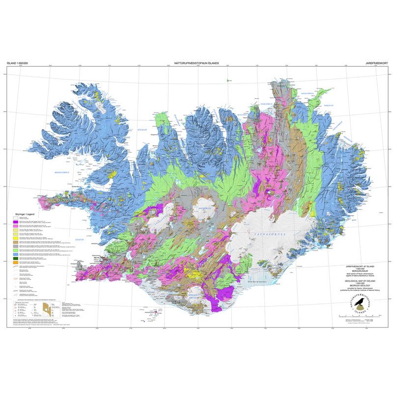
Gagnasafn (GDB) NI_J600v_berg_2.utg: Jarðfræðikorti af Íslandi – Berggrunnur – 1:600.000 [Geological Map of Iceland – Bedrock geology – 1:600.000]. Berggrunnskort af Íslandi sýnir stærstu drættina í jarðfræði landsins. Jarðlög eru flokkuð eftir aldri, gerð og samsetningu. Kortið sýnir vel gosbelti landsins og dreifingu gossstöðva frá nútíma. Nútímahraunum er skipt í forsöguleg og söguleg hraun (yngri en 871 e. Kr. ). [The Geological Map of Iceland shows the main features of the bedrock geology. Formation are classified by age, type, and composition. The map clearly shows the island's volcanic zones and the distribution of the recent eruption sites. Lava fields of the Holocene are shown as pre-historic or historic (younger than AD 871].]
-

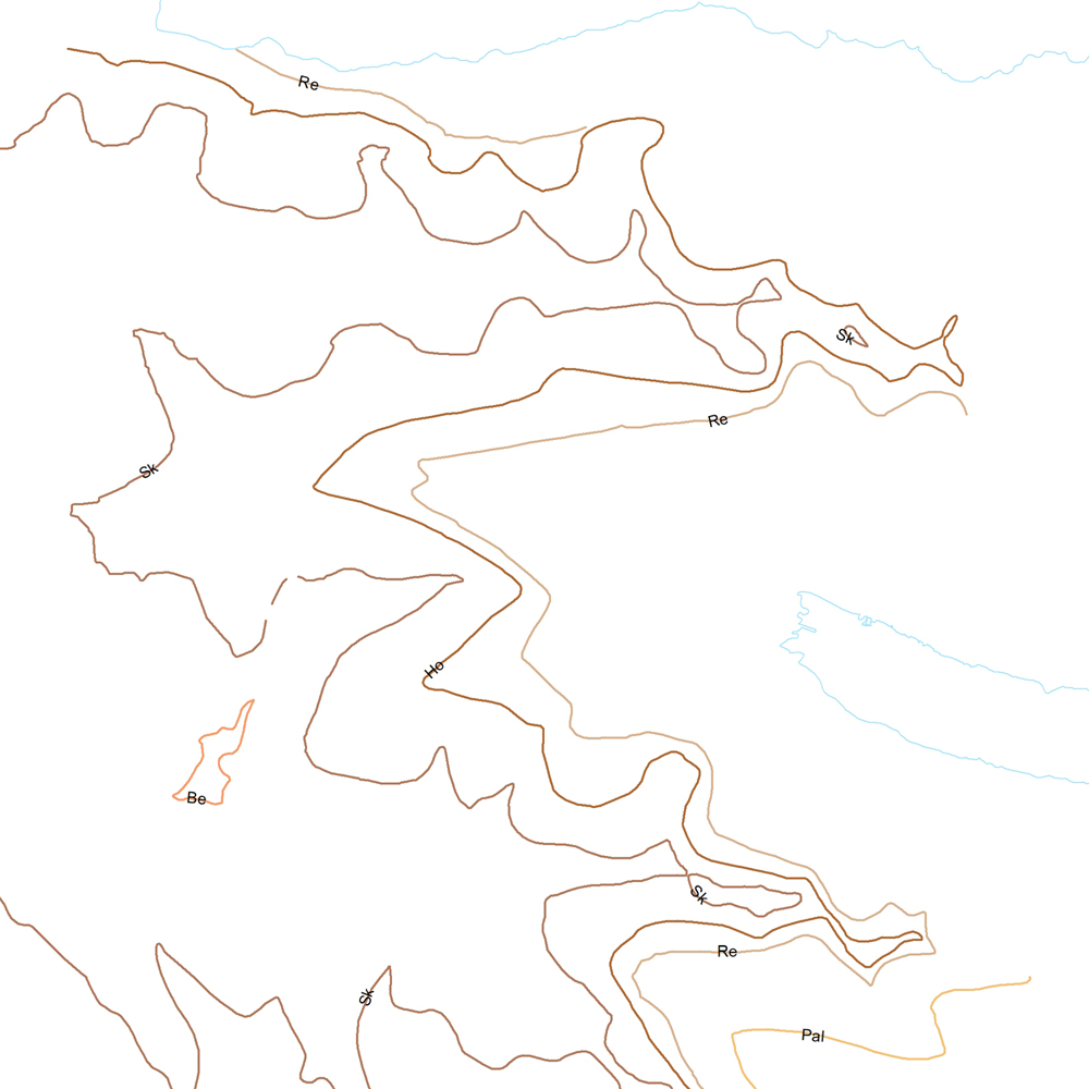
Gagnasafn (GDB) NI_J600v_hoggun: Jarðfræðikorti af Íslandi – Höggun – 1:600.000 [Geological Map of Iceland – Tectonics – 1:600.000]. Höggunarkort af Íslandi sýnir jarðfræði landsins á nýstárlegan hátt. Jarðlög eru flokkuð eftir aldri en ekki eftir gerð og samsetningu. Sýnd eru eldstöðvakerfi, þ.e. megineldstöðvar, sprungu- og gangareinar, bæði virkar og útkulnaðar. Einnig eru sýnd helstu brotakerfi landsins og halli jarðlaga. Kortið gefur innsýn í jarðfræðilega byggingu landsins. [The Tectonic Map of Iceland gives a new view of the country's geology. The rocks are classified by age, but not by type or composition. Volcanic systems including central volcanoes, fissures and dyke swarms, both active and extinct, are shown, as are the island's principal fracture zones and the dip of rock layers. The map thus gives a useful insight into the geological structure of the country.]
-
Þekja [layer] j100v_vesturgosbelti_gigar_1utg_p: Gervigígar, punktalag. [Rootless cones, point data.]
-
GEUS map database covering Denmark and Greenland
-
Niðurhalsþjónustur Orkustofnunar
-

The map displays bedrock formations at or near the surface of the land, on the sea floor above the continental crust that forms the Canadian landmass, and oceanic crust surrounding the landmass. The bedrock units are grouped and coloured according to geological age and composition. The colours of offshore units and oceanic crust are paler and more generalized than those on land, although the constituent units offshore are still easily discernible from their dashed boundaries. This colour design, coupled with the use of a white buffer zone at the coast allows the coastline of Canada to be readily distinguished and still show the grand geological architecture of the Canadian landmass. The map also shows major faults that have disrupted the Earth's crust, onshore and offshore, and a variety of special geological features such as kimberlite pipes, which locally contain diamonds, impact structures suspected to have been caused by meteorites, and extinct and active spreading centres in the surrounding oceans.
-
The dataset GE.Bedrock 1:1 million covering the whole of Sweden is available in this OGC WFS service. The service delivers data compliant to the Inspire theme Geology encoded as GeoSciML 4.0. FeatureTypes included are MappedFeature and GeologicUnit. MappedFeatures (geometry) are specified by GeologicUnits containing information on lithology and age. The underlying dataset GE.Bedrock 1:1 million also contains information on shear displacement structures like faults that are not included in this service.
-
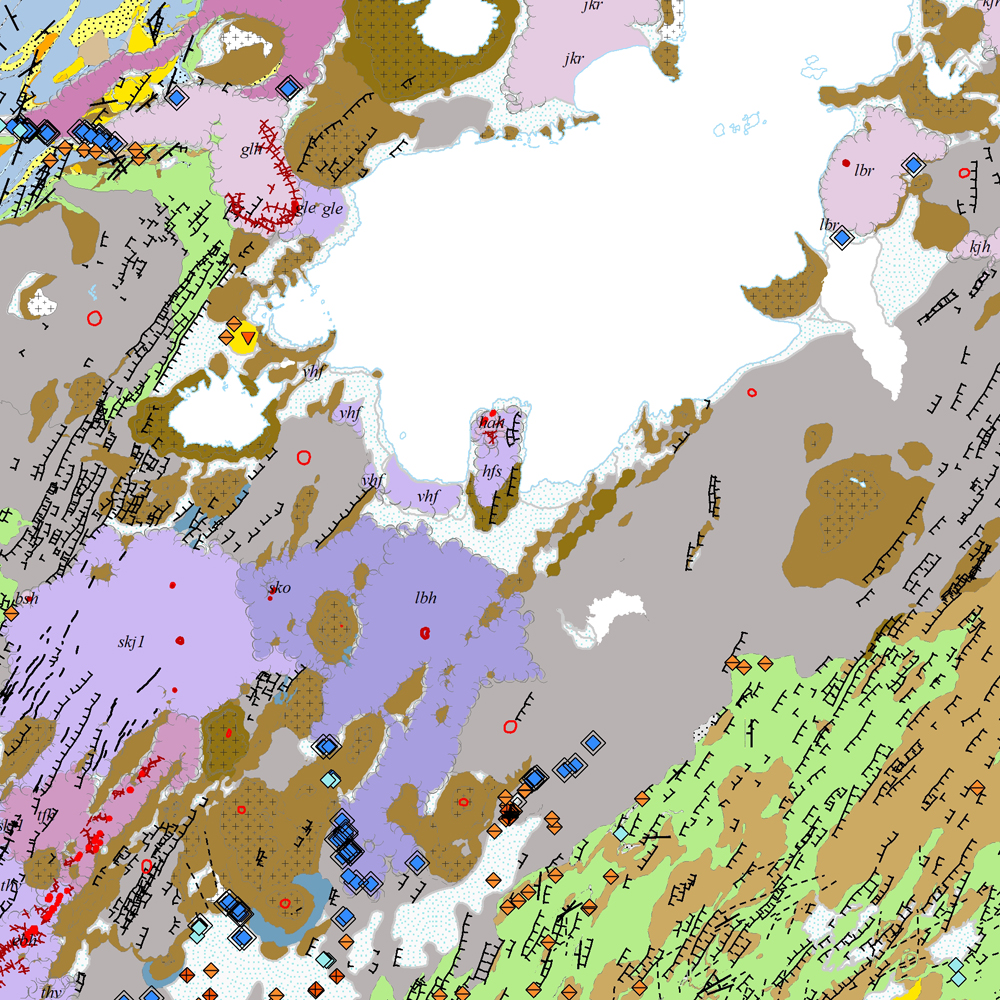
Gagnasafn [GDB] NI_J100v_Vesturgosbelt_1.utg: Jarðfræðikort af Vesturgosbelti Íslands í mælikvarði 1:100.00, 1. útg. [Geological map of the Western Volcanic Zone of Iceland in the scale of 1:100.000, 1st ed.] Kortið sýnir jarðlög, gíga, höggun, strik og halla, framhlaup og niðurföll, steingervinga, jökulrákir, jökulgarða, jökulkembur, malarása og fornar strandlínur stöðuvatna. Jarðlög eru flokkuð eftir aldri, gerð og samsetningu. Kortið var unnin í samstarfi Náttúrufræðistofnunar Íslands og Íslensku Orkurannsoknastofa. Tilvísun: Birgir V. Óskarsson, Ögmundur Erlendsson, Robert A. Askew, Árni Hjartarson, Magnús Á. Sigurgeirsson, Skafti Brynjólfsson og Sveinn Jakobsson 2022. Jarðfræðikort af Vesturgosbelti. 1.100.000. 1. útg. Garðabær: Náttúrufræðistofnun Íslands, Íslenskar Orkurannsóknir og Umhverfis- og Auðlindaráðuneytið. [The map displays bedrock geology, volcanic craters, tectonics, strike and dips, landslides and collapse pits, fossils, glacial striations, glacial moraines, flutes, eskers and ancient lake strandlines. Bedrock is classified by age, type, and composition. The map was completed in a collaborative project between the Icelandic Institute of Natural History and the Icelandic Geosurvey. Bibliographic reference: Birgir V. Óskarsson, Ögmundur Erlendsson, Robert A. Askew, Árni Hjartarson, Magnús Á. Sigurgeirsson, Skafti Brynjólfsson og Sveinn Jakobsson 2022. Geological map of the Western Volcanic Zone, Iceland. 1:100.000. 1st edition. Garðabær: Icelandic Institute of Natural History, Iceland GeoSurvey and Ministry for the Environment and Natural Resources.]
-
Þekja (layer) j100v_austurland_millilog_1utg_li:: Gjóskulög á Austfjörðum. [Tuff layers in Eastern Iceland.] Línur sýna staðsetningu stærstu gjóskulagana á Austfjörðum. Gjóskulögin eru fengin úr ýmsum kortum og kortlagningu Birgis V. Óskarssonar. Gögn eru flokkuð eftir ÍST120:2012 staðlinum, nema þrjá fitjueigindir: myndunKodi = Heiti myndunarinnar (skammstöfun) myndunIS = Heiti myndunarinnar (á íslenskuc) myndunEN = Heiti myndunarinnart (á ensku) [Lines show the location of largest tuff deposits in Eastern Iceland. The tuff layers are derived from older maps and the mapping of Birgir V. Óskarsson. The data follows the ÍST120:2012 data standard with the three additional feature attributes: myndunKodi = Lithostratigraphic unit (abbreviation) myndunIS = Lithostratigraphic unit (in Icelandic) myndunEN = Lithostratigraphic unit (in English)]
-
Niðurhalsþjónustur LBHÍ