 Arctic SDI catalogue
Phanerozoic
Type of resources
Available actions
Topics
Keywords
Contact for the resource
Provided by
Formats
Representation types
Update frequencies
status
Scale
Resolution
-

Compilation of drillholes for mineral exploration and Quaternary studies in the Province of Saskatchewan, Canada. This dataset is compilation of uranium drillholes prior to 2007, and since that time has expanded to include metallic and industrial mineral exploration drillholes and surficial sedimentology drillholes. This is an ongoing compilation whereby recent drillholes that become publically available are added. In addition, improvements are frequently made to more historic drillholes with spurious information. The dataset is not an exhaustive list of drillholes in Saskatchewan. **Please Note – All published Saskatchewan Geological Survey datasets, including those available through the Saskatchewan Mining and Petroleum GeoAtlas, are sourced from the Enterprise GIS Data Warehouse. They are therefore identical and share the same refresh schedule.
-
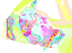
The map displays bedrock formations at or near the surface of the land, on the sea floor above the continental crust that forms the Canadian landmass, and oceanic crust surrounding the landmass. The bedrock units are grouped and coloured according to geological age and composition. The colours of offshore units and oceanic crust are paler and more generalized than those on land, although the constituent units offshore are still easily discernible from their dashed boundaries. This colour design, coupled with the use of a white buffer zone at the coast allows the coastline of Canada to be readily distinguished and still show the grand geological architecture of the Canadian landmass. The map also shows major faults that have disrupted the Earth's crust, onshore and offshore, and a variety of special geological features such as kimberlite pipes, which locally contain diamonds, impact structures suspected to have been caused by meteorites, and extinct and active spreading centres in the surrounding oceans.
-

The Canada Geological Map Compilation (CGMC) is a database of previously published bedrock geological maps sourced from provincial, territorial, and other geological survey organizations. The geoscientific information included within these source geological maps wasstandardized, translated to English, and combined to provide complete coverage of Canada and support a range of down-stream machine learning applications. Detailed lithological, mineralogical, metamorphic, lithostratigraphic, and lithodemic information was not previously available as onenational-scale product. The source map data was also enhanced by correcting geometry errors and through the application of a new hierarchical generalized lithology classification scheme to subdivide the original rocks types into 35 classes. Each generalized lithology is associated with asemi-quantitative measure of classification uncertainty. Lithostratigraphic and lithodemic names included within the source maps were matched with the Lexicon of Canadian Geological Names (Weblex) wherever possible and natural language processing was used to transform all of the available text-basedinformation into word tokens. Overlapping map polygons and boundary artifacts across political boundaries were not addressed as part of this study. As a result, the CGMC is a patchwork of overlapping bedrock geological maps with varying scale (1:30,000-1:5,000,000), publication year (1996-2023), andreliability. Preferred geological and geochronological maps of Canada are presented as geospatial rasters based on the best available geoscientific information extracted from these overlapping polygons for each map pixel. New higher resolution geological maps will be added over time to fill datagaps and to update geoscientific information for future applications of the CGMC.