 Arctic SDI catalogue
Énergie
Type of resources
Available actions
Keywords
Contact for the resource
Provided by
Years
Formats
Representation types
Update frequencies
status
Service types
Scale
-
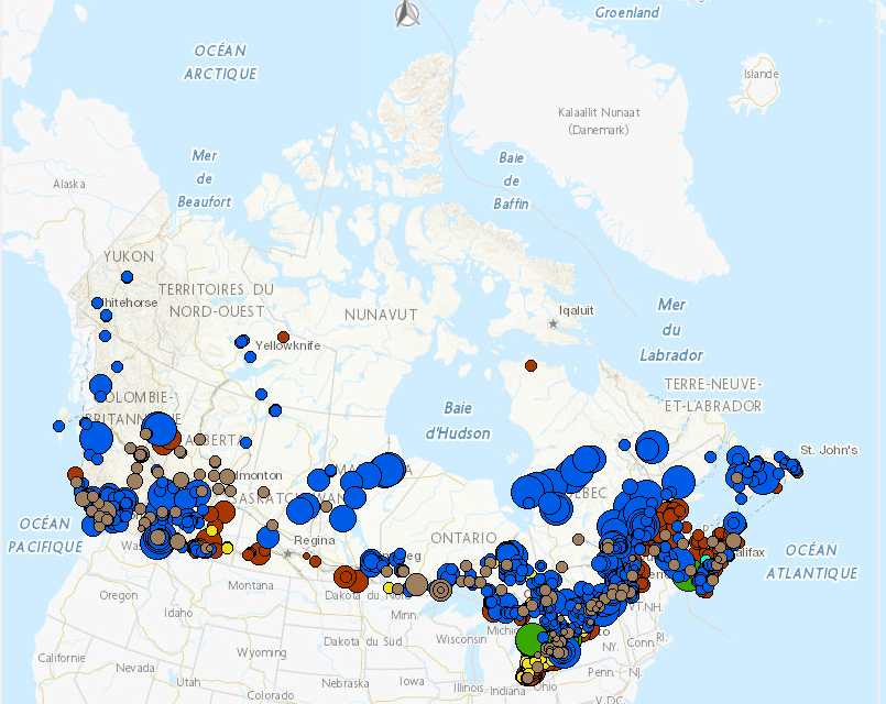
This Web Map Service depicts the location of clean electricity generating facilities by type of clean energy source and power generation capacity. Clean energy sources shown on the map include biomass, hydro, nuclear, solar, tidal and wind. The data comes from the provinces and territories, other federal departments and clean energy associations in Canada. The service is one of many themes mapped in the web mapping application Map of Clean Energy Resources and Projects (CERP) in Canada.
-

Sub-surface facilities used for storing natural gas. The facilities are usually hollowed-out salt domes, geological reservoirs (depleted oil or gas field) or water bearing sands (called aquifers) topped by an impermeable cap rock. Mapping Resources implemented as part of the North American Cooperation on Energy Information (NACEI) between the Department of Energy of the United States of America, the Department of Natural Resources of Canada, and the Ministry of Energy of the United Mexican States. The participating Agencies and Institutions shall not be held liable for improper or incorrect use of the data described and/or contained herein. These data and related graphics, if available, are not legal documents and are not intended to be used as such. The information contained in these data is dynamic and may change over time and may differ from other official information. The Agencies and Institutions participants give no warranty, expressed or implied, as to the accuracy, reliability, or completeness of these data.
-

This dataset uses RADARSAT Constellation Mission (RCM) Synthetic Aperture Radar (SAR) satellite images to identify open water regions within ice-covered rivers during winter, with the aim to assess hydrokinetic resources near remote communities reliant on diesel fuel for electricity generation. The data is processed with the HyRASS, a machine learning-based SAR image processing and classification algorithm. Disclaimer: This dataset was designed to identify open water regions within ice-covered rivers for assessing hydrokinetic resources near remote communities reliant on diesel fuel for electricity generation and is subject to the following limitations: • This dataset was derived from RADARSAT Constellation Mission (RCM) Synthetic Aperture Radar (SAR) satellite images. While these images are generally reliable, they are subject to inherent limitations, including resolution constraints, potential distortion, and occasional inaccuracies in real-time conditions capture. • The HyRASS algorithm is designed to pinpoint open water areas using satellite images, with a particular emphasis on RCM quad polarization (QP) imagery. This specialization means that its effectiveness depends on the accessibility of this specific type of imagery. Consequently, the data it produces might not cover a broad spectrum of time periods. For more reliable results, it's essential to classify areas more regularly, ensuring that detected open water regions are consistent over time. This dataset is intended for preliminary assessment and should not be the sole basis for making critical decisions or investments related to hydrokinetic energy projects. Further validation and in-depth analysis are strongly recommended, and users should conduct their own due diligence and additional research to verify the data accuracy and relevance for specific applications. By accessing and using this dataset, users acknowledge and accept these disclaimers. The providers of this dataset explicitly absolve themselves of any responsibility or liability for any consequences arising from the use, reliance upon, or interpretation of this dataset. Users are advised that their use of the dataset is at their own risk, and they assume full responsibility for any actions or decisions made based on the information contained therein. This disclaimer is in accordance with applicable laws and regulations, and by accessing or utilizing the dataset, users agree to release the providers of this dataset from any legal claims, damages, or liabilities that may arise from such use.
-

Facilities designed to recover natural gas liquids from a stream of natural gas. These facilities control the quality of the natural gas to be marketed. Mapping Resources implemented as part of the North American Cooperation on Energy Information (NACEI) between the Department of Energy of the United States of America, the Department of Natural Resources of Canada, and the Ministry of Energy of the United Mexican States. The participating Agencies and Institutions shall not be held liable for improper or incorrect use of the data described and/or contained herein. These data and related graphics, if available, are not legal documents and are not intended to be used as such. The information contained in these data is dynamic and may change over time and may differ from other official information. The Agencies and Institutions participants give no warranty, expressed or implied, as to the accuracy, reliability, or completeness of these data. Parent Collection: [North American Cooperation on Energy Information, Mapping Data](https://open.canada.ca/data/en/dataset/aae6619f-f9f3-435d-bc32-42decd58b674)
-

Natural gas onshore facilities used to receive, unload, load, store, gasify, liquefy, process and transport by ship, natural gas that is imported from a foreign country, exported to a foreign country, or interior commerce. Mapping Resources implemented as part of the North American Cooperation on Energy Information (NACEI) between the Department of Energy of the United States of America, the Department of Natural Resources of Canada, and the Ministry of Energy of the United Mexican States. The participating Agencies and Institutions shall not be held liable for improper or incorrect use of the data described and/or contained herein. These data and related graphics, if available, are not legal documents and are not intended to be used as such. The information contained in these data is dynamic and may change over time and may differ from other official information. The Agencies and Institutions participants give no warranty, expressed or implied, as to the accuracy, reliability, or completeness of these data.
-

Natural Resources Canada’s Major Projects Inventory published annually, provides a snapshot of major natural resource projects in Canada that are either currently under construction or are planned within the next 10 years. The inventory includes major projects that increase, extend or improve natural resource production in Canada, including new extraction projects, infrastructure projects, major processing facilities and large expansion projects. In addition, the inventory includes information on the value, timing and geographic location of projects. To be included in the inventory, projects in the energy and mining sectors must meet a minimum capital worth threshold of $50 million and electricity and forest sector projects must meet a threshold of $20 million. Also included in the inventory are clean energy and clean technology projects, which must meet a minimum capital worth threshold of $10 million. DISCLAIMER: Data is sourced from federal, provincial, and territorial databases, publicly accessible websites, and other sources, including CANOILS. Data and maps are for illustrative purposes only. Users understand that, although all efforts have been made to accurately and exhaustively compile, locate and classify projects, the authors do not guarantee the accuracy and/or the comprehensiveness of the data and assume no responsibility for errors or omissions. The routes of the proposed transmission lines and pipelines are approximations, often using only start and end points. In support of this initiative, proponents and partners are encouraged to contact Natural Resources Canada should they identify any significant errors or omissions.
-

Border crossings of electric transmission lines. Mapping Resources implemented as part of the North American Cooperation on Energy Information (NACEI) between the Department of Energy of the United States of America, the Department of Natural Resources of Canada, and the Ministry of Energy of the United Mexican States. The participating Agencies and Institutions shall not be held liable for improper or incorrect use of the data described and/or contained herein. These data and related graphics, if available, are not legal documents and are not intended to be used as such. The information contained in these data is dynamic and may change over time and may differ from other official information. The Agencies and Institutions participants give no warranty, expressed or implied, as to the accuracy, reliability, or completeness of these data. Parent Collection: [North American Cooperation on Energy Information, Mapping Data](https://open.canada.ca/data/en/dataset/aae6619f-f9f3-435d-bc32-42decd58b674)
-

Border crossings of liquids pipelines. Mapping Resources implemented as part of the North American Cooperation on Energy Information (NACEI) between the Department of Energy of the United States of America, the Department of Natural Resources of Canada, and the Ministry of Energy of the United Mexican States. The participating Agencies and Institutions shall not be held liable for improper or incorrect use of the data described and/or contained herein. These data and related graphics, if available, are not legal documents and are not intended to be used as such. The information contained in these data is dynamic and may change over time and may differ from other official information. The Agencies and Institutions participants give no warranty, expressed or implied, as to the accuracy, reliability, or completeness of these data. Parent Collection: [North American Cooperation on Energy Information, Mapping Data](https://open.canada.ca/data/en/dataset/aae6619f-f9f3-435d-bc32-42decd58b674)
-

Border crossings of natural gas pipelines. Mapping Resources implemented as part of the North American Cooperation on Energy Information (NACEI) between the Department of Energy of the United States of America, the Department of Natural Resources of Canada, and the Ministry of Energy of the United Mexican States. The participating Agencies and Institutions shall not be held liable for improper or incorrect use of the data described and/or contained herein. These data and related graphics, if available, are not legal documents and are not intended to be used as such. The information contained in these data is dynamic and may change over time and may differ from other official information. The Agencies and Institutions participants give no warranty, expressed or implied, as to the accuracy, reliability, or completeness of these data. Parent Collection: [North American Cooperation on Energy Information, Mapping Data](https://open.canada.ca/data/en/dataset/aae6619f-f9f3-435d-bc32-42decd58b674)
-

The Remote Communities Energy Database is a public resource that provides pertinent factual information about the generation and use of electricity and other energy sources for all remote communities in Canada. Communities are identified as remote communities if they are not currently connected to the North-American electrical grid nor to the piped natural gas network; and is a permanent or long-term (5 years or more) settlement with at least 10 dwellings. The Remote Communities Energy Database is the only national data source on energy in remote communities that is publically available on one centralized site. The Remote Communities Energy Database allows users to search and conduct analyses of remote communities and their energy context. Users are also able download the data from the Remote Communities Energy Database dataset in CSV (i.e., excel compatible) format. This data is collected from a number of sources including the remote communities themselves, local utilities, provincial and territorial government’s, Indigenous and Northern Affairs Canada (INAC), Statistics Canada, Natural Resources Canada (NRCan) and various other stakeholders.