 Arctic SDI catalogue
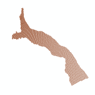
High Arctic
Type of resources
Available actions
Topics
Keywords
Contact for the resource
Provided by
Years
Formats
Representation types
Update frequencies
status
-
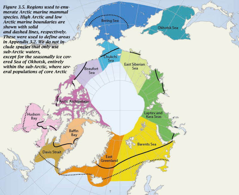
The Arctic Ocean and adjacent seas (AOAS) with the approximate delineation of the 16 regions examined for the occurrence of marine fish species. - <a href="http://www.caff.is/assessment-series/10-arctic-biodiversity-assessment/211-arctic-biodiversity-assessment-2013-chapter-6-fishes" target="_blank"> Arctic Biodiversity Assessment, Chapter 6: Fishes</a
-
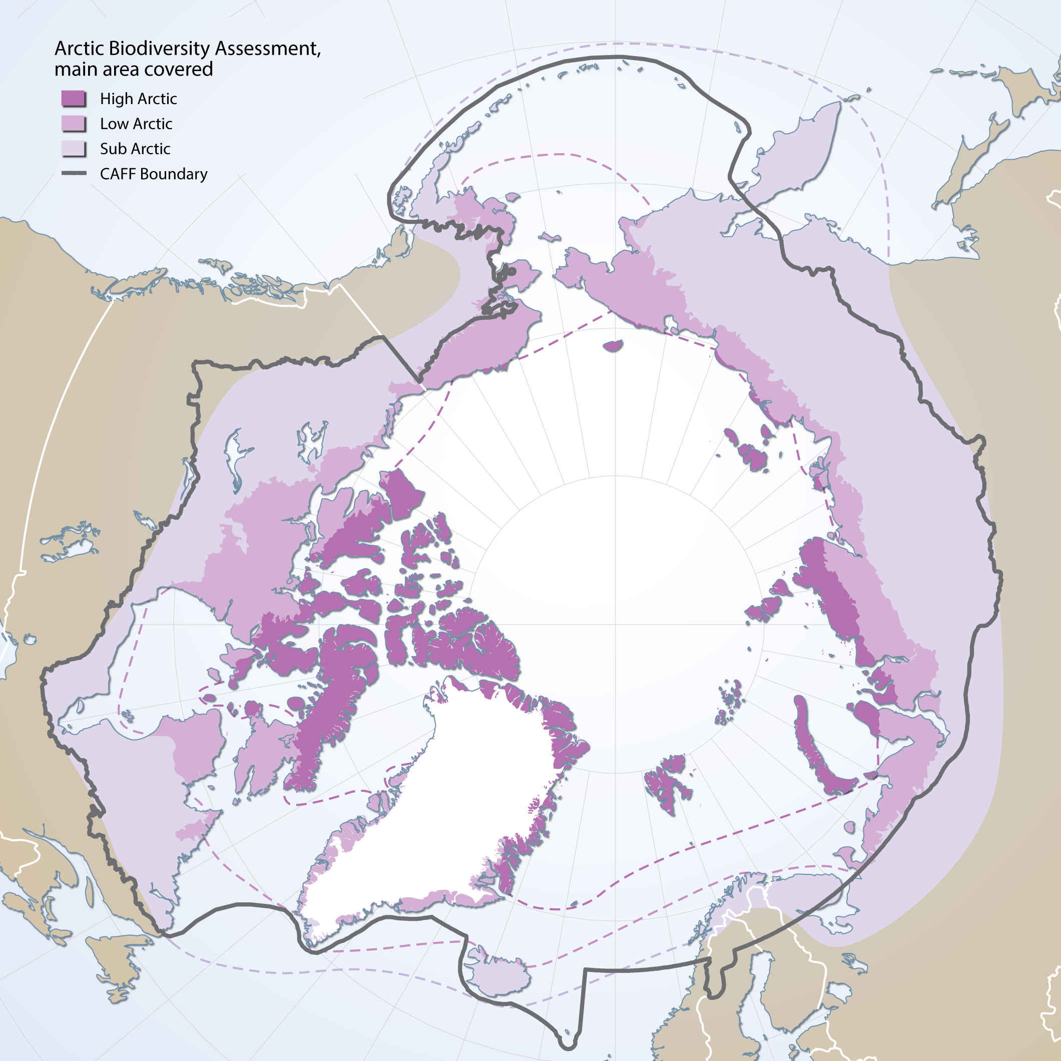
Boundaries of the geographic area covered by the Arctic Biodiversity Assessment. Includes sub, low and high Arctic bounbaries
-
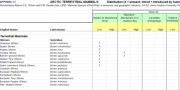
Appendix 3.1 Arctic Terrestrial mammals: Distribution (X = present; Introd = Introduced by humans) by broad geographic region and low or high arctic zones Nomenclature follows D.E. Wilson and D.M. Reeder (eds.) 2005. Mammal Species of the World: a taxonomic and geographic reference. 3rd Ed. Johns Hopkins University Press, Baltimore.
-
The Beaufort Sea and Mackenzie Delta dataset comes from the Petroleum and Environmental Management Tool (PEMT). The online tool was decommissioned in 2019 and the data was transferred to Open Data in order to preserve it. The PEMT was originally developed in 2009 to help guide development in the Canadian Arctic by Indian and Northern Affairs Canada (INAC). The online tool mapped the sensitivities of a variety of Arctic features, ranging from whales to traditional harvesting, across the Arctic. The tool was intended to aid government, oil and gas companies, Aboriginal groups, resource managers and public stakeholders in better understanding the geographic distribution of areas which are sensitive for environmental and socio-economic reasons. The study area and analytical resolution was defined using the oil and gas leasing grid within the Beaufort Sea. The study area has been the scene of oil and gas exploration activity since 1957. Oil was first discovered at Atkinson Point in 1969 and major gas fields in the early 1970s. Such finds spurred the proposal of the Mackenzie Valley Pipeline in 1974 and the addition of exploration and investment offshore. Exploration and drilling continued both onshore and offshore until the mid-1970s with the release of the Berger Report, which recommended a 10-year moratorium on the construction of the pipeline. After the release of the Berger Report, the pace of onshore activity declined but offshore exploration escalated in the 1980s. Offshore exploration was facilitated with innovative operating techniques and new offshore platforms that extended the ability to operate in the short open-water season and ice. With the minor exception of the small onshore gas field at Ikhil, no oil or gas has been commercially produced in the area. DISCLAIMER: Please refer to the PEMT Disclaimer document or the Resource Constraints - Use Limitation in the Additional Information section below. Note: This is one of the 3 (three) datasets included in the PEMT application which includes the High Arctic and Eastern Arctic datasets.
-
The Eastern Arctic dataset comes from the Petroleum and Environmental Management Tool (PEMT). The online tool was decommissioned in 2019 and the data was transferred to Open Data in order to preserve it. The PEMT was originally developed in 2009 to help guide development in the Canadian Arctic by Indian and Northern Affairs Canada (INAC). The online tool mapped the sensitivities of a variety of Arctic features, ranging from whales to traditional harvesting, across the Arctic. The tool was intended to aid government, oil and gas companies, Aboriginal groups, resource managers and public stakeholders in better understanding the geographic distribution of areas which are sensitive for environmental and socio-economic reasons. The study area is located east of Baffin Island, Nunavut and encompasses marine habitat in Baffin Bay and Davis Strait. The boundaries of the study area are based on NOGB leasing grids applied in the Eastern Arctic, under which exploration and production licenses may be issued. Although portions of the study area hold high oil and gas potential and several small oil fields and substantial reserves of gas have been found since the 1960s in the north Baffin region, exploration for oil and gas has been limited to seismic operations and geological field work. DISCLAIMER: Please refer to the PEMT Disclaimer document or the Resource Constraints - Use Limitation in the Additional Information section below. Note: This is one of the 3 (three) datasets included in the PEMT application which includes the Beaufort Sea and Mackenzie Delta and High Arctic datasets.
-
The High Arctic dataset comes from the Petroleum and Environmental Management Tool (PEMT). The online tool was decommissioned in 2019 and the data was transferred to Open Data in order to preserve it. The PEMT was originally developed in 2009 to help guide development in the Canadian Arctic by Indian and Northern Affairs Canada (INAC). The online tool mapped the sensitivities of a variety of Arctic features, ranging from whales to traditional harvesting, across the Arctic. The tool was intended to aid government, oil and gas companies, Aboriginal groups, resource managers and public stakeholders in better understanding the geographic distribution of areas which are sensitive for environmental and socio-economic reasons. The study area is located in the High Arctic Archipelago and contains both marine and terrestrial components. The boundaries of the study area are based on the NOGB leasing grids applied in the High Arctic, under which exploration, significant discovery and production licenses may be issued. The Sverdrup Basin (and Lancaster Sound) has the highest known oil and gas potential of the sedimentary basins of the Arctic Islands (Nunavut Planning Commission 2000) and it is expected that there is oil and gas potential on Melville Island and Bathurst Island (Sivummut Economic Development Strategy Group 2003). To date, no gas has been produced, and 321,470 m³ of oil has been produced from the Bent Horn oil field (Morrell et al. 1995). DISCLAIMER: Please refer to the PEMT Disclaimer document or the Resource Constraints - Use Limitation in the Additional Information section below. Note: This is one of the 3 (three) datasets included in the PEMT application which includes the Beaufort Sea and Mackenzie Delta and Eastern Arctic datasets.