 Arctic SDI catalogue
Irregular
Type of resources
Available actions
Topics
Keywords
Contact for the resource
Provided by
Years
Formats
Scale
Resolution
-
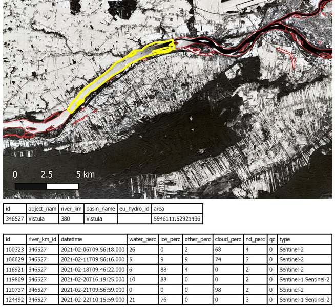
The Aggregated River and Lake Ice Extent (ARLIE) product is a spatially aggregated information on surface water conditions of rivers and lakes. ARLIE information is stored in a geodatabase, enriched every day from the different River and Lake Ice Extent products (RLIE S1, RLIE S2, RLIE S1+S2) for the entire EEA38 and the United Kingdom. It provides percent coverage of snow-covered or snow-free ice on lakes and on 10 km river sections described by the EU-HYDRO river and lake network database. The ARLIE data is stored in a PostGIS persistent geodatabase. They can be retrieved by using a specific REST API. Users can query ice sheet summary information of river segments and lakes (ARLIE statistics) together with the geometry and caracteristics of the features on which these statistics were estimated. All geometry features are delivered in the ETRS89 LAEA (EPSG:3035) coordinate reference system. ARLIE is one of the products of the pan-European High-Resolution Snow and Ice service (HR-S&I), which are provided at high spatial resolution from the Sentinel-2 and Sentinel-1 constellations data from September 1, 2016 onwards.
-
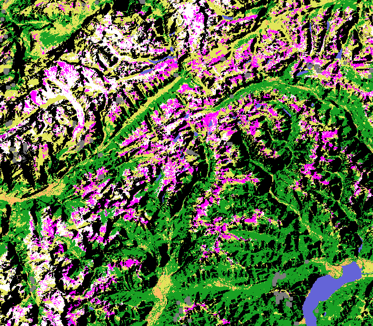
The Copernicus Wet/Dry Snow (WDS) product is generated in near real-time for the entire EEA38 and the United Kingdom, based on radar satellite data from the Sentinel-1 constellation. The product differentiates the snow state conditions within the snow mask defined by the FSCTOC information (snow fraction at the top of canopy - see the Copernicus Fractional Snow Cover product) with a spatial resolution of 60 m x 60 m. In other words, it provides a binary discrimination of wet and dry snow, identifying patchy snow or snow free areas. The WDS product is distributed in raster files covering an area of 110 km by 110 km with a pixel size of 60 m by 60 m in UTM/WGS84 projection, which corresponds to the Sentinel-2 input L1C product tile. Each product is composed of two separate GeoTIFF files corresponding to the different layers of the product (the snow state classification -SSC- and the associated quality layer -QCSSC-) and a metadata file. The WDS is one of the products of the pan-European High-Resolution Snow & Ice service (HR-S&I), which are provided at high spatial resolution (20 m x 20 m and 60 m x 60 m), from the Sentinel-2 and Sentinel-1 constellations data from September 1, 2016 onwards.
-
The Aggregated Water and Ice (AWIC) product is a spatially aggregated information on surface water conditions of rivers and lakes. AWIC information is stored in a geodatabase, enriched every day from the different Water/Ice Cover products (WIC S1, WIC S1, WIC S1+S2) for the entire EEA38 and the United Kingdom. It provides percent coverage of snow-covered or snow-free ice on lakes and on 10 km river sections described by the EU-HYDRO river and lake network database. AWIC data is stored in a PostGIS persistent geodatabase. They can be retrieved by using a specific REST API. Users can query ice sheet summary information of river segments and lakes (AWIC statistics) together with the geometry and caracteristics of the features on which these statistics were estimated. All geometry features are delivered in the ETRS89 LAEA (EPSG:3035) coordinate reference system. AWIC is one of the products of the pan-European High-Resolution Water, Snow and Ice service (HR-WSI), which are provided at high spatial resolution from the Sentinel-2 and Sentinel-1 constellations data from September 1, 2016 onwards.
-
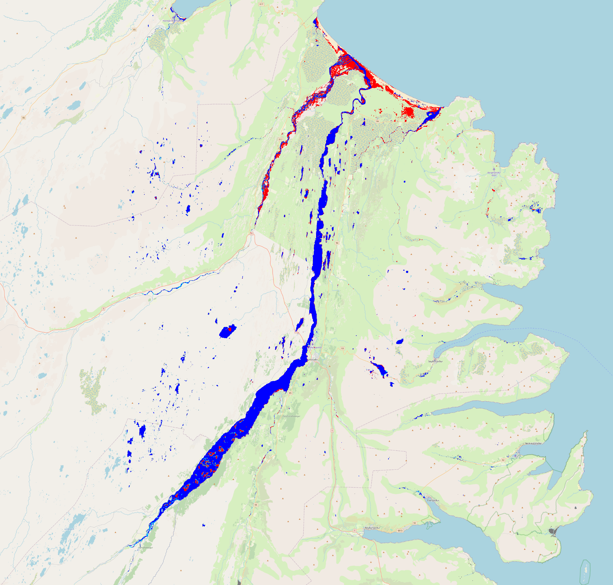
The Sentinel-1 & Sentinel-2 Water and Ice Cover (WIC S1+S2) product is generated in near real-time at European scale. It combines ice and water extent information derived from radar data from the Sentinel-1 constellation (WIC S1), and from optical data from the Sentinel-2 constellation (WIC S2). The WICS1+S2 product is processed when both WIC S1 and WIC S2 data are available on the same day. It provides the water and ice extent on water bodies (rivers and lakes), at a spatial resolution of 20 m x 20 m. WIC S1+S2 is one of the products of the pan-European High-Resolution Water Snow & Ice portfolio (HR-WSI), which are provided at high spatial resolution from the Sentinel-2 and Sentinel-1 constellations data from September 1, 2016 onwards. The WIC S1+S2 product is distributed in raster files covering an area of 110 km by 110 km with a pixel size of 20 m by 20 m in UTM/WGS84 projection, which corresponds to the Sentinel-2 input L1C product tile. Each product is composed of separate files corresponding to the different layers of the product, and another metadata file."
-

The Wet/Dry Snow (WDS) product is generated in near real-time at European scale based on C-band SAR satellite data from the Sentinel-1 constellation within the fractional snow cover on top of canopy (FSCTOC) derived from overlapping optical satellite data from the Sentinel-2 constellation. The product provides the snow state condition (wet / dry) for surfaces covered by snow (FSCTOC >= 90%) for non-forested land areas with a spatial resolution of 60 m x 60 m. Urban areas, forest and water bodies as well as clouds and cloud shadows from the S2 based FSCTOC product of the same date are masked. WDS is one of the products of the pan-European High-Resolution Water Snow & Ice portfolio (HR-WSI), which are provided at high spatial resolution from the Sentinel-2 and Sentinel-1 constellations data from September 1, 2016 onwards. The WDS product is distributed in raster files covering an area of 110 km by 110 km with a pixel size of 60 m by 60 m in UTM/WGS84 projection, which corresponds to the Sentinel-2 input L1C product tile. Each product is composed of separate files corresponding to the different layers of the product, and another metadata file.