 Arctic SDI catalogue
snow
Type of resources
Available actions
Topics
Keywords
Contact for the resource
Provided by
Years
Formats
Representation types
Update frequencies
status
Service types
Scale
Resolution
-

Manual snow survey (active & inactive) locations as part of the BC Snow Survey program.
-
Snow survey administrative basin areas, which are components of the BC snow survey network. Basin codes are used as basis of snow survey station names, and for some reporting purposes.
-
Locations of automated snow weather stations, active and inactive. Automated snow weather stations are components of the BC snow survey network.
-
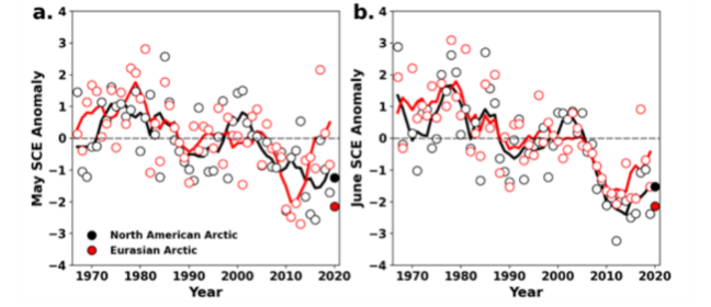
Monthly snow cover extent (SCE) for Arctic land areas (>60° N) for (a) May and (b) June 1967–2020, a 54-year record. Anomalies are relative to the 1981–2010 average and standardised (each observation was differenced from the mean and divided by the standard deviation, and thus unitless). Solid black and red lines depict 5-year running means for North America and Eurasia, respectively. Filled circles are used to highlight 2020 anomalies. (Mudryk et al. 2020). STATE OF THE ARCTIC TERRESTRIAL BIODIVERSITY REPORT - Chapter 2 - Page 23 - Figure 2.3
-

The Sentinel-2 Snow Phenology (SP S2) product is generated once a year at European scale, based on Fractional Snow Cover (FSC) products calculated from Sentinel-2 optical data. This product describes the snow season in terms of temporality as it provides, within an hydrological year and for each pixel, the number of days with snow cover, as well as the first and the last day of the longest observed snow period. It has a spatial resolution of 20 m x 20 m, as does the input FSC product. The SP S2 product is distributed in raster files covering an area of 110 km by 110 km with a pixel size of 20 m by 20 m in UTM/WGS84 projection, which corresponds to the Sentinel-2 input L1C product tile. Each product is composed of separate files corresponding to the different layers of the product, and another metadata file." The product is also available in another projection as tiles aligned with the Pan-European High-Resolution Layers in the European grid (ETRS89 LAEA - EPSG: 3035) at 20 m x 20 m and 100 m x 100 m. SP S2 is one of the products of the pan-European High-Resolution Water Snow & Ice portfolio (HR-WSI), which are provided at high spatial resolution from the Sentinel-2 and Sentinel-1 constellations data from September 1, 2016 onwards.
-

A wide range of different territorial, federal, and first nation governments have a role in monitoring water. The water monitoring sites data set compiles these varied sources into a single source with the intent to provide a 'one-stop shop' when searching for water monitoring data. Information contained includes the 'who, what, when, and where' of water monitoring by providing contact information, sample type, sample period, and location. Distributed from [GeoYukon](https://yukon.ca/geoyukon) by the [Government of Yukon](https://yukon.ca/maps) . Discover more digital map data and interactive maps from Yukon's digital map data collection. For more information: [geomatics.help@yukon.ca](mailto:geomatics.help@yukon.ca)
-

This is the metadata covering the Sentinel-1 and Sentinel-2 Snow Phenology (SPS1S2) product. It is generated once a year over high-mountain areas at European scale, based on daily cumulative Gap-Filled Fractional Snow Cover (GFSC) products calculated from Sentinel-2 optical and Sentinel-1 radar data. This product describes the snow season in terms of temporality as it provides, for each pixel, the number of days with snow cover, as well as the first and the last day of the longest observed snow period. It has a spatial resolution of 60 m x 60 m, as does the input GFSC product. Each product is composed of separate files corresponding to the different layers of the product, and another metadata file." The product is also available in another projection as tiles aligned with the Pan-European High-Resolution Layers in the European grid (ETRS89 LAEA - EPSG: 3035) at 60 m x 60 m and 100 m x 100 m. SP S2+S2 is one of the products of the pan-European High-Resolution Water Snow & Ice portfolio (HR-WSI), which are provided at high spatial resolution from the Sentinel-2 and Sentinel-1 constellations data from September 1, 2016 onwards.
-
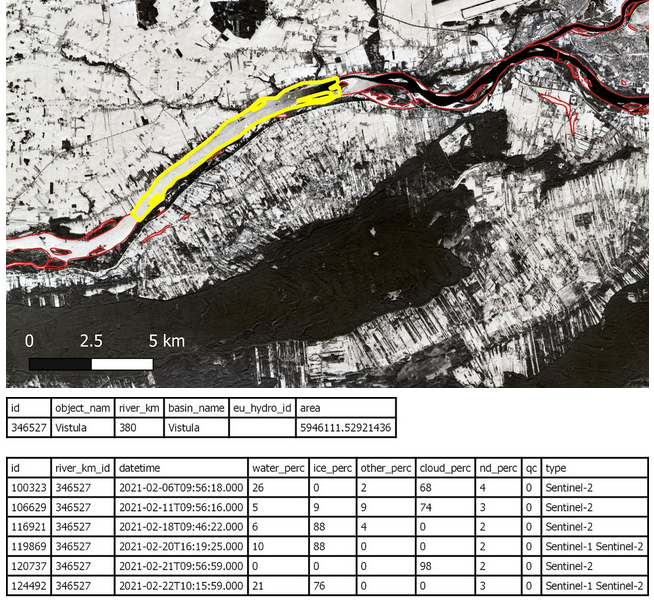
The Aggregated River and Lake Ice Extent (ARLIE) product is a spatially aggregated information on surface water conditions of rivers and lakes. ARLIE information is stored in a geodatabase, enriched every day from the different River and Lake Ice Extent products (RLIE S1, RLIE S2, RLIE S1+S2) for the entire EEA38 and the United Kingdom. It provides percent coverage of snow-covered or snow-free ice on lakes and on 10 km river sections described by the EU-HYDRO river and lake network database. The ARLIE data is stored in a PostGIS persistent geodatabase. They can be retrieved by using a specific REST API. Users can query ice sheet summary information of river segments and lakes (ARLIE statistics) together with the geometry and caracteristics of the features on which these statistics were estimated. All geometry features are delivered in the ETRS89 LAEA (EPSG:3035) coordinate reference system. ARLIE is one of the products of the pan-European High-Resolution Snow and Ice service (HR-S&I), which are provided at high spatial resolution from the Sentinel-2 and Sentinel-1 constellations data from September 1, 2016 onwards.
-

The Sentinel-1 and Sentinel-2 Snow Phenology (SP S1+S2) product is generated once a year over high-mountain areas at European scale, based on daily cumulative Gap-Filled Fractional Snow Cover (GFSC) products calculated from Sentinel-2 optical and Sentinel-1 radar data. This product describes the snow season in terms of temporality as it provides, for each pixel, the number of days with snow cover, as well as the first and the last day of the longest observed snow period. It has a spatial resolution of 100 m x 100 m. Each product is composed of separate files corresponding to the different layers of the product, and another metadata file. The product is also available in another projection as tiles aligned with Sentinel-2 (UTM/WGS84) at 60 m x 60 m. SP S1+S2 is one of the products of the pan-European High-Resolution Water Snow & Ice portfolio (HR-WSI), which are provided at high spatial resolution from the Sentinel-2 and Sentinel-1 constellations data from September 1, 2016 onwards. t.
-
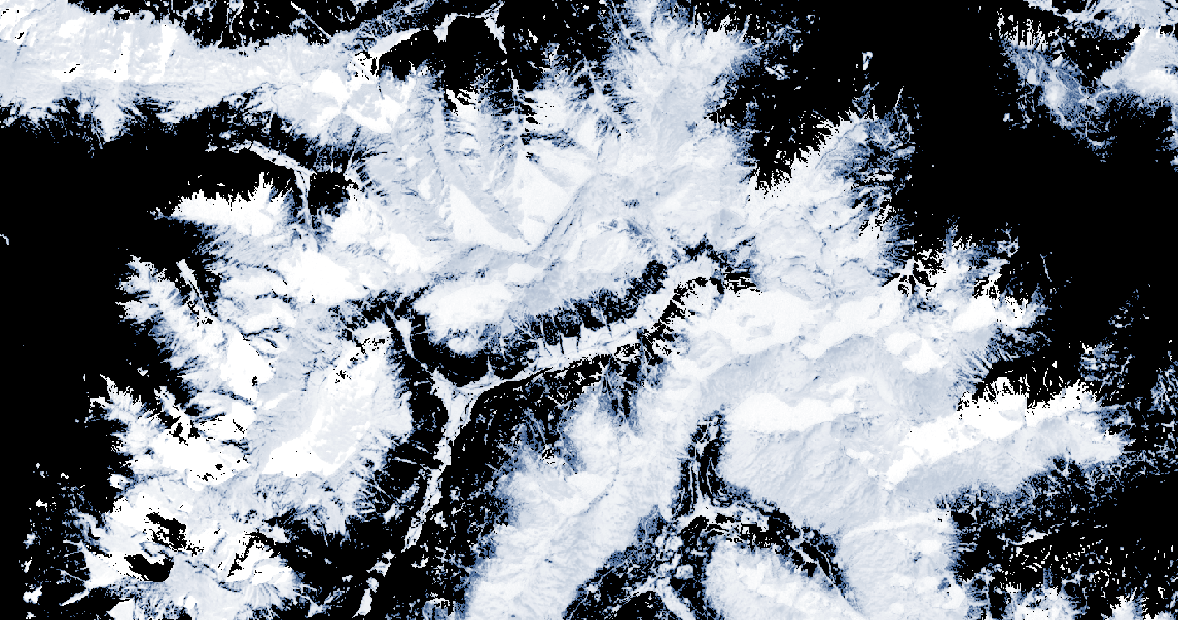
The Copernicus Fractional Snow Cover (FSC) product is generated in near real-time for the entire EEA38 and the United Kingdom, based on optical satellite data from the Sentinel-2 constellation. The product provides the fraction of the surface covered by snow at the top of canopy (FSC-TOC) and on ground (FSC-OG) per pixel as a percentage (0% – 100%) with a spatial resolution of 20 m x 20 m. FSC is one of the products of the pan-European High-Resolution Snow & Ice service (HR-S&I), which are provided at high spatial resolution (20 m x 20 m and 60 m x 60 m), from the Sentinel-2 and Sentinel-1 constellations data from September 1, 2016 onwards. The FSC product is distributed in raster files covering an area of 110 km by 110 km with a pixel size of 20 m by 20 m in UTM/WGS84 projection, which corresponds to the Sentinel-2 input L1C product tile. Each product is composed of seven separate files corresponding to the different layers of the product, and another metadata file.