 Arctic SDI catalogue
monitoring
Type of resources
Available actions
Topics
Keywords
Contact for the resource
Provided by
Years
Formats
Representation types
Update frequencies
status
Service types
Scale
Resolution
-
-
Map of all groundwater wells and groundwater monitoring stations registered in GIN (Groundwater Information Network) and additional references layers related to Groundwater Geoscience Program of Natural Resources Canada. This data is distributed amongst several database and mediated to a single entry point dynamically. Some layers that have large amount of features will display generalised maps at national scale in order to improve drawing performance and then switch to individual features at local scale.
-
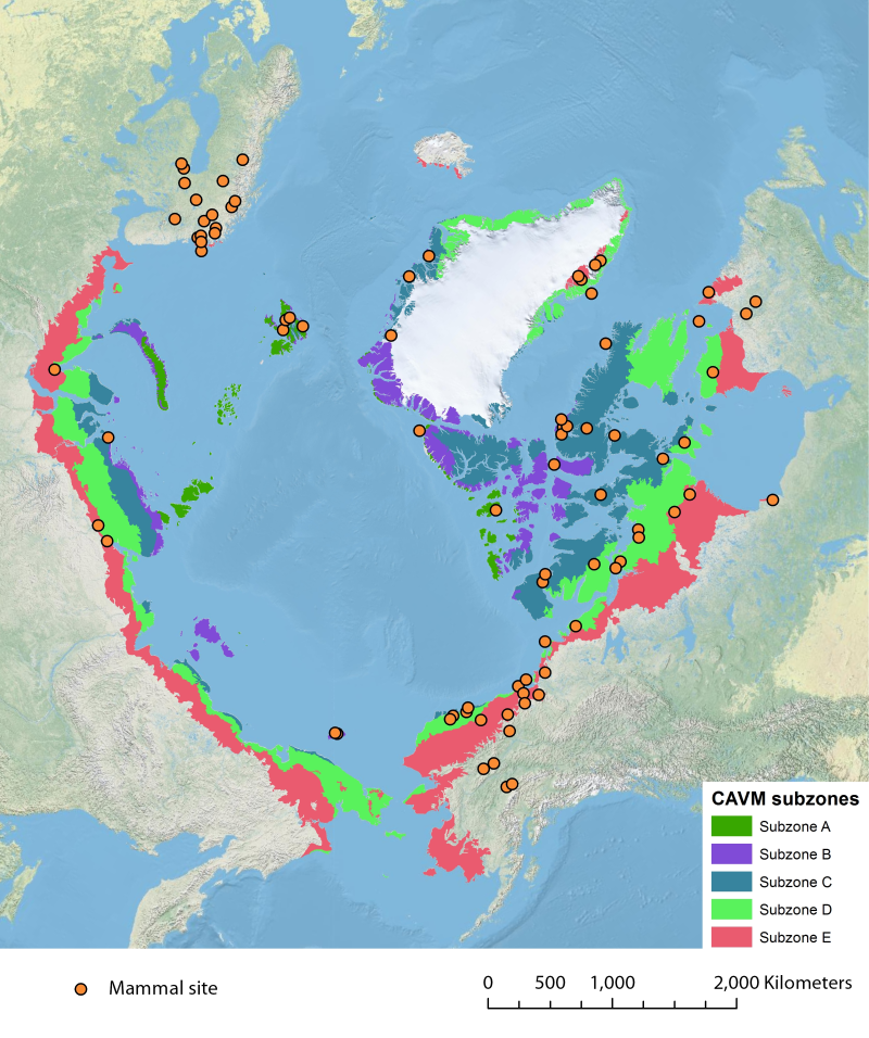
Location of long-term mammal monitoring sites and programs. Comes from the Arctic Terrestrial Biodiversity Monitoring Plan is developed to improve the collective ability of Arctic traditional knowledge holders, northern communities and scientists to detect, understand and report on long-term change in Arctic terrestrial ecosystems and biodiversity..
-
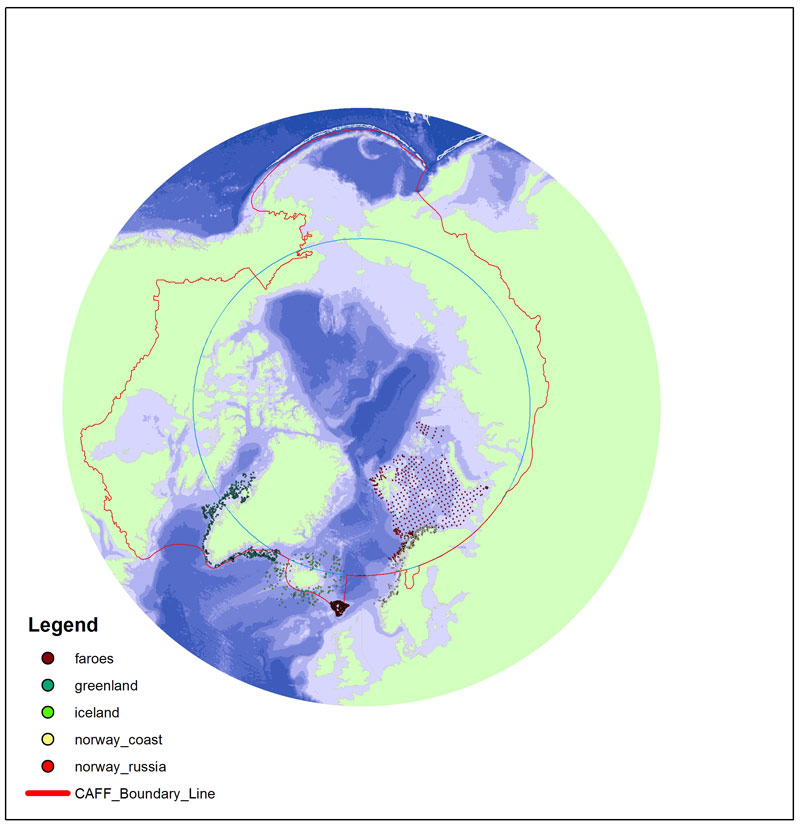
Long-term monitoring programs on benthic fauna are missing for large areas of the Arctic. In areas where repeated monitoring has occurred, it is difficult to compare data due to different sampling approaches and different targets of monitoring efforts. There is a need for an international standardization of long- term benthic monitoring. The CBMP Benthos Expert Network has identified potential ways to improve benthic monitoring coverage, and has come up with a map showing a Pan Arctic station map.
-
<img width="80px" height="67px" alt="logo" align="left" hspace="10px" src="http://geo.abds.is/geonetwork/srv/eng//resources.get?uuid=7d8986b1-fbd1-4e1a-a7c8-a4cef13e8eca&fname=cbird.png">The Circumpolar Seabird Monitoring Plan is designed to 1) monitor populations of selected Arctic seabird species, in one or more Arctic countries; 2) monitor, as appropriate, survival, diets, breeding phenology, and productivity of seabirds in a manner that allows changes to be detected; 3) provide circumpolar information on the status of seabirds to the management agencies of Arctic countries, in order to broaden their knowledge beyond the boundaries of their country thereby allowing management decisions to be made based on the best available information; 4) inform the public through outreach mechanisms as appropriate; 5) provide information on changes in the marine ecosystem by using seabirds as indicators; and 6) quickly identify areas or issue in the Arctic ecosystem such as declining biodiversity or environmental pressures to target further research and plan management and conservation measures. - <a href="http://caff.is" target="_blank"> Circumpolar Seabird Monitoring plan </a>
-
Bird Studies Canada WMS/WFS Server for bird distribution and abundance data, and related information. Bird Studies Canada gratefully acknowledges the support of Environment Canada - Canadian Information System for the Environment in developing this service.
-
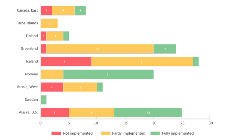
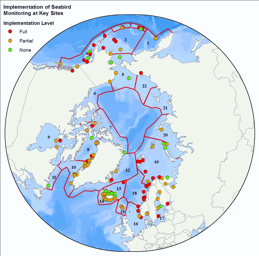
The number of key sites (monitored colonies) for seabirds (in 22 CSMP ecoregions) by country (a total of 125 sites). Sites are categorized as having fully, partially, or not met the CSMP criteria for parameters monitored (see 2.6.2). Data were from Appendix 3 of the CSMP (Irons et al. 2015); the degree of implementation may have changed at some sites since this summary was compiled. STATE OF THE ARCTIC MARINE BIODIVERSITY REPORT - <a href="https://arcticbiodiversity.is/findings/seabirds" target="_blank">Chapter 3</a> - Page 134 - Figure 3.5.2
-

The province of PEI has been monitoring dissolved oxygen in some Island estuaries since 2015.