 Arctic SDI catalogue
Macroalgae
Type of resources
Topics
Keywords
Contact for the resource
Provided by
Formats
Representation types
Update frequencies
status
-

To support the surveillance of key macroalgae and non-indigenous species in Nova Scotia and New Brunswick, five quantitative PCR (qPCR) assays were designed and tested at 111 sites in 2022-2023 targeting the following non-indigenous macroalgal species: Antithamnion sparsum, Bonnemaisonia hamifera, Codium fragile, Dasysiphonia japonica, Fucus serratus. All assays were developed in 2022 by the Center for Environmental Genomics Applications (CEGA, Newfoundland, Canada) except Antithamnion sparsum, for which an assay was developed in 2023 by the Aquatic Biotechnology Laboratory (ABL) at the Bedford Institute of Oceanography. All amplification was performed by the ABL in 2022-2023. The assay developed for Fucus serratus was later determined to be non-specific, and amplifies both F. serratus and Fucus distichus. Cite this data as: Krumhansl K, Brooks C, Lowen B, DiBacco C, (2025). Quantitative PCR (qPCR) of Key Macroalgal Non-Indigenous Species in Nova Scotia and New Brunswick Waters. Version 1.5. Fisheries and Oceans Canada. Samplingevent dataset. https://ipt.iobis.org/obiscanada/resource?r=quantitative_qpcr_macroalgal_nonindigenous_species_novascotia_newbrunswick_2022_2023&v=1.5 For additional information please see: LeBlanc F., Belliveau V., Watson E., Coomber C., Simard N., DiBacco C., Bernier R., Gagné N. 2020. Environment DNA (eDNA) detection of marine aquatic invasive species (AIS) in Eastern Canada using a targeted species-specific qPCR approach. Management of Biological Invasions 11(2):201-217 Krumhansl K.A., Brooks C.M., Lowen B., O’Brien J., Wong M., DiBacco C. Loss, resilience and recovery of kelp forests in a region of rapid ocean warming. Annals of Botany 2024 Mar 8; 133(1):73-92 Brooks C.M., Krumhansl K.A. 2023. First record of the Asian Antithamnion sparsum Tokida, 1932 (Ceramiales, Rhodophyta) in Nova Scotia, Canada. BioInvasions Records 12(3):745-725.
-
Macroalgae dominated areas with a vegetated cover above 25%, located in the coastal zone of the Estuary and the Gulf of St. Lawrence (Quebec) This dataset was designed for Environment and Climate Change Canada's (ECCC) National Environmental Emergencies Center (NEEC) for oil spill preparedness and response. The polygons of this layer were selected from the surface geodatabase of coastal ecosystems from the UQAR-MPO project Mapping coastal ecosystems of the Estuary and Gulf of St. Lawrence. Are represented in this dataset exclusively the polygons whose plant dominance corresponds to a class of macroalgae and presenting a semi-vegetated (25-75%) or vegetated (75-100%) cover. The study area includes all of the estuarine and maritime coasts of Quebec, with the exception of certain sectors, including most of the Lower North Shore and Anticosti Island, with the exception of villages of Kegaska, la Romaine, Chevery, Blanc-Sablon and Port-Menier. Some islands off the estuary and gulf coasts are part of the region covered, such as Île d'Orléans, Isle-aux-Coudres, Île Verte and Île Bonaventure. The mapping of coastal ecosystems was carried out jointly by the Laboratory for Dynamics and Integrated Coastal Zone Management (LDGIZC) of the University of Quebec at Rimouski as part of the Coastal Resilience Project (https: //ldgizc.uqar.ca/Web/projets/projet-resilience-cotiere) funded by the MELCC; and by the Fisheries and Oceans Canada team, as part of its Integrated marine response planning (IMRP) component of the Oceans Protection Plan (OPP),with the objective of updating the Marine Oil Spill Preparedness and Response Regime of Canada. The master geodatabase of coastal ecosystems is hosted and distributed by UQAR on their SIGEC-Web mapping platform: https://ldgizc.uqar.ca/Web/sigecweb The macroalgae characterization was mainly carried out from the photo-interpretation of RGBI aerial photos acquired by the DFO (2015-2022) and oblique helicopter photos acquired by UQAR in 2017. Data from 3155 sampling stations, conducted aboard small boats during DFO field campaigns (2017-2023) were used to detail the nature of algal communities and validate the photo-interpretation. Credits © UQAR-MPO (2025, Laboratoire de dynamique et de gestion intégrée des zones côtières, Pêches et Océans Canada) Référence Provencher-Nolet, L., Paquette, L., Pitre, L.D., Grégoire, B. and Desjardins, C. 2024. Cartographie des macrophytes estuariens et marins du Québec. Rapp. Tech. Can. Sci. halieut. Aquat. 0000 : v + 99 p. Grégoire, B., Pitre, L.D., Provencher-Nolet, L., Paquette, L. and Desjardins, C. 2024. Distribution d’organismes marins de la zone côtière peu profonde du Québec recensés par imagerie sous-marine de 2017 à 2021. Rapp. tech. can. sci. halieut. aquat. 0000 : v + 78 p. Grégoire, B. 2022. Biodiversité du relevé côtier Planification pour une intervention environnementale intégrée dans l’estuaire et le golfe du Saint-Laurent (2017–2021). Observatoire global du Saint-Laurent. [Jeu de données] Jobin, A., Marquis, G., Provencher-Nolet, L., Gabaj Castrillo. M. J., Trubiano C., Drouet, M., Eustache-Létourneau, D., Drejza, S. Fraser, C. Marie, G. et P. Bernatchez (2021) Cartographie des écosystèmes côtiers du Québec maritime — Rapport méthodologique. Chaire de recherche en géoscience côtière, Laboratoire de dynamique et de gestion intégrée des zones côtières, Université du Québec à Rimouski. Rapport remis au ministère de l’Environnement et de la Lutte contre les changements climatiques, septembre 2021, 98 p.
-
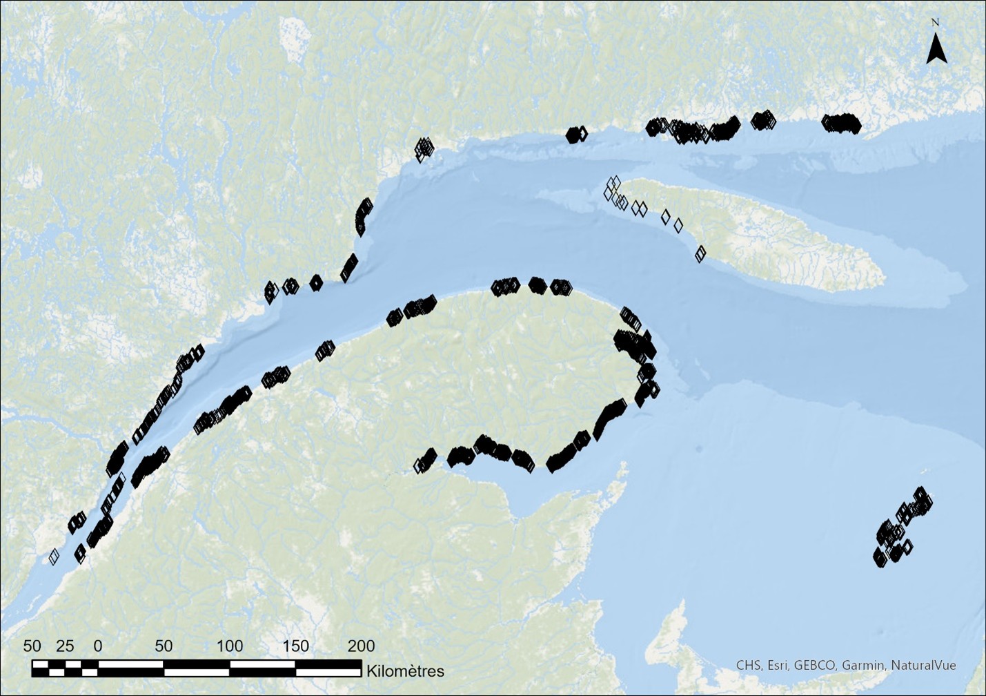
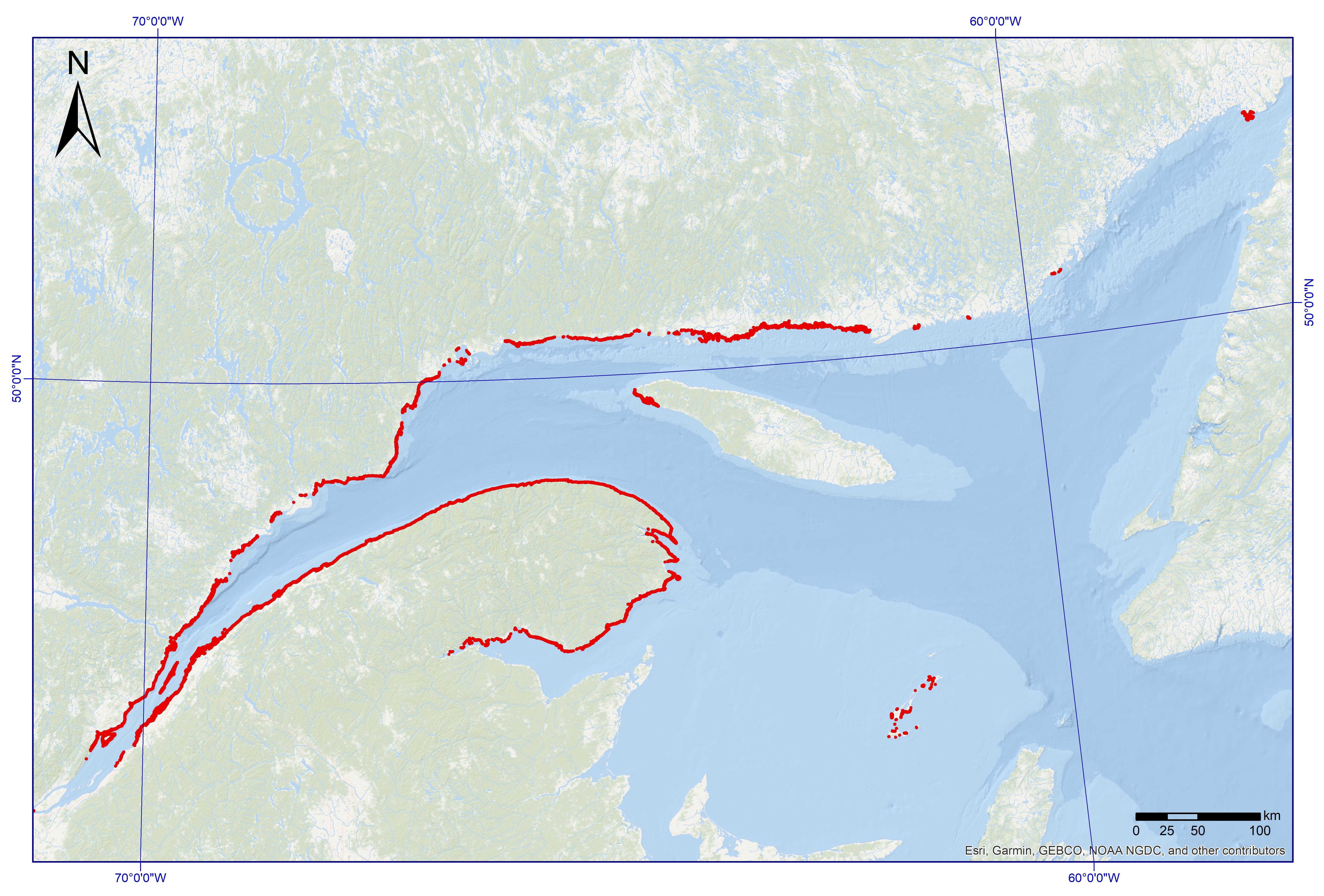
Between 2017 and 2024, underwater imaging sampling campaigns were conducted by Fisheries and Oceans Canada across a broad area of the shallow coastal zone of the St. Lawrence Estuary and Gulf. The sampling targeted the lower intertidal and subtidal zones, to a maximum depth of approximately 10 m, with an emphasis on eelgrass beds and macroalgae. These targeted surveys were primarily intended to produce ground-truth data for the mapping of estuarine and marine macrophytes of the Québec maritime region (Provencher-Nolet et al., 2025), supporting oil spill preparedness and response activities. This dataset summarizes information generated from the analysis of underwater video footage collected at 3,179 sampling stations using small boats equipped with a pole-mounted camera system, as described in Grégoire et al. (2025). The dataset documents multiple characteristics of coastal ecosystems, including the cover of erect vegetation, vegetation assemblages, dominant and minor vegetation, substrates, fauna, as well as the presence of encrusting algae, for each sampling station. The different attributes recorded during video analysis, along with certain identification criteria, are presented in the visual dictionary of Grégoire et al. (2022).
-

The Planning for an Environmental Response (PIER) initiative falls under the umbrella of the Government of Canada’s Oceans Protection Plan (OPP), whose goal is preserving marine ecosystems vulnerable to increased transportation and the development of the marine industry. The PIERs’ main mandate is to acquire and update biological sensitivity data under its jurisdiction for preparation and response purposes in the event of an oil spill. This dataset contains all observations of marine organisms noted during the analysis of 2959 underwater images sampled over a large extent of the coastal zone (≤10 m) of the Estuary and the Gulf of St. Lawrence (Quebec region). The dataset includes 21 490 occurrences of 150 taxa and informal categories including macroalgae, invertebrates and fish. Underwater images were collected between 2017 and 2021 according to a directed sampling protocol whose primary goal was to map large seaweed and eelgrass beds. Images were normally recorded as videos using a GoPro Hero camera installed on a pole and placed near the seabed from a small boat. The collected data served primarily as ground-truth data to validate coasting zone mapping based on aerial photographs within the framework of the PIER's initiative. The two files provided (DarwinCore format) are complementary and are linked by the "eventID" key. The "event_information" file includes generic event information, including date and location. The "taxon_occurrence" file includes the original identifiers of the observed organisms (verbatimIdentification field), identification remarks and their taxonomy. Taxonomic names were verified on the World Register of Marine Species (WoRMS) to match recognized standards. The WoRMS match has been put in the scientificNameID field in the occurrence file. Data quality control was performed using the R packages obistools and worrms. All sampling locations were plotted on a map to perform a visual check confirming that the latitude and longitude coordinates were within the described sampling area. A visual dictionary was developed as an identification aid and accompanies this dataset (unilingual french only, the English version will be published soon). More data, including a visibility index, estimated macroalgae and eelgrass cover, substrate type and dominant macroalgae and animals were recorded but not included in this dataset. These data may be made available upon request. Credits Provencher-Nolet, L., Paquette, L., Pitre, L.D., Grégoire, B. and Desjardins, C. 2024. Cartographie des macrophytes estuariens et marins du Québec. Rapp. Tech. Can. Sci. halieut. Aquat. 3617 : v + 99 p. Grégoire, B., Pitre, L.D., Provencher-Nolet, L., Paquette, L. and Desjardins, C. 2024. Distribution d’organismes marins de la zone côtière peu profonde du Québec recensés par imagerie sous-marine de 2017 à 2021. Rapp. tech. can. sci. halieut. aquat. 3616 : v + 78 p.
-

The Planning for an Environmental Response (PIER) initiative falls under the umbrella of the Government of Canada's Oceans Protection Plan (OPP), whose goal is preserving marine ecosystems vulnerable to increased transportation and the development of the marine industry (https://pm.gc.ca/en/news/backgrounders/2016/11/07/canadas-oceans-protection-plan-preserving-and-restoring-canadas). The PIER was established in response to recommendations made in a 2013 report "A review of Canada's ship-source spill preparedness and response regime " by the Tanker Safety Expert Panel (https://tc.canada.ca/en/marine-transportation/marine-safety/tanker-safety-expert-panel). One of the recommendations calls on Fisheries and Oceans (DFO) to work with Environment and Climate Change Canada (ECCC) to collect and compile information on sensitive species and environments for each Canadian Coast Guard (CCG) response area and make it publicly available. The PIERs’ main mandate is to acquire and update biological sensitivity data under its jurisdiction for preparation and response purposes in the event of an oil spill. With DFO-Science, PIER supports ECCC's National Environmental Emergencies Centre (NEEC) and the CCG in their preparations and responses through the sharing of data on biological sensitivities, the development of response tools and expert advice. In this vein, DFO published an analysis in 2018 that aimed to identify the most vulnerable components of the St. Lawrence in order to prioritize them during data collection if gaps were identified (Desjardins et al. 2018). This exercise highlighted the vulnerability of several biological components and important data gaps, particularly in coastal areas. As a result of this finding, the Quebec region PIEI team embarked on a collaborative project with the Université du Québec à Rimouski (UQAR) to map eelgrass beds, tidal marshes and macroalgal beds. In consultation with other DFO-Science data producers, this team has also created datasets adapted for response purposes, notably regarding bivalves and marine mammals. These layers may be used for oil spill preparedness and response by DFO-Quebec Region's Environmental Incident Coordinator, NEEC and CCG. Several of them, deemed relevant in the first 72 hours following a spill, have been transmitted to the NEEC.