 Arctic SDI catalogue
Invertebrates
Type of resources
Available actions
Topics
Keywords
Contact for the resource
Provided by
Formats
Representation types
Update frequencies
status
Scale
-

This dataset derives from a series of beam trawl tows conducted during several research surveys in coastal areas of the St. Lawrence Estuary, between Portneuf-sur-Mer and Pointe-des-Monts, and between June and October of 2019, 2020, 2021 and 2022. It contains catch data for fish and invertebrates (occurrence and catch weights by species), in trawl tows conducted at depths ranging from 10 to 50 meters. Data were collected in various cruises: • June 28th to July 5th 2019 (NGCC Leim) • September 30th to October 9th 2019 (NGCC Leim) • October 1st to October 10th 2020 (NGCC Leim) • April 22nd to May 5th 2021 (NGCC Perley) • October 15th to October 24th 2021 (NGCC Perley) • June 24th to July 15th 2022 (NGCC LEIM) The beam trawl used to generate this data set consists of a frame (width of 2.8 m, height of 0.8 m) equipped with a 6.5 m long net with 40 mm diamond mesh, which is lined with a net (skirt) of square mesh (5 mm) at the cod-end (length 2 m) and a protective apron (75 mm mesh) on the ventral portion. Three skid chains are linked at the base of the skates. Each station corresponds to a 5 to 10 minutes tow along an isobath at a speed of about 2 knots. At each haul, the trawl catch was placed on a sorting table on the deck and the organisms were sorted and identified at the best possible taxonomic resolution. Most taxa were independently weighed. Some invertebrates taxa were subsampled, counted and weighted in order to estimate their contribution (weight and number) to the total catch. Additionally, the first 30 fish of each species were measured and weighed individually. Taxonomic names were verified on the World Register of Marine Species (WoRMS) to match recognized standards. The WoRMS match has been put in the scientificNameID field in the occurrence file. Data quality control was performed using the R packages obistools and worrms. All sampling locations were plotted on a map to perform a visual check confirming that the latitude and longitude coordinates were within the described sampling area. Data acquired during the research surveys additionally included: 1) occurrence data on epibenthic invertebrates and submerged aquatic vegetation in photo samples from a drop camera system, 2) occurrence data on fish and invertebrate taxa in video samples collected using a baited underwater video system (BUV), 3) substrate classification based on drop camera photo samples, 4) oceanographic measurements of the water column from Seabird 19plus V2 profiling CTD (conductivity, temperature, depth, photosynthetic active radiation, pH, dissolved oxygen), 5) nutrients (NO2, NO3, NH4, PO4, SiO3) and dissolve organic carbon (DOC) concentrations, and 6) current speed and direction from tilt meters. The first two items are available as independent data on the OBIS portal. To obtain data from items 3-6 and/or biological data collected on fish and invertebrate taxa, please contact David Lévesque or Marie-Julie Roux. The research surveys were undertaken by the Department of Fisheries and Oceans Canada as part of the baseline program of the Ocean Protection Plan. This initiative aimed to acquire environmental baseline data contributing to the characterization of important coastal areas and in support of evidence-based assessments and management decision-making for preserving marine ecosystems. Which contribute to the elaboration of conservation objectives based on an ecosystem assessment approach for fishery stock assessment requires the development of sampling methods to maximize the data collection on the ecosystem, while minimizing the impact on organisms and the marine environment. This project aims at characterising the coastal ecosystem of the St. Lawrence Estuary between Portneuf-sur-Mer and Godbout (QC), including the physico-chemistry of water, phytoplankton, zooplankton, submerged vegetation, benthic habitats as well as assemblages of fish and invertebrates. Sampling was performed by combining conventional methods such as CTD profiling, zooplankton nets, and beam trawl, with non-extractive methods such as dropped photo cameras and stereoscopic baited video camera systems. The data collected will help define baseline ecosystem conditions in the study area; explore the links between environmental conditions, habitat structure and biological assemblages; identify important habitats for marine species; as well as the evaluation of the performance of visual sampling methods compared to conventional methods. The results will make it possible to optimize the seasonal or annual monitoring in order to better understand the direct and indirect effects of human activities in coastal environments. This project was funded by the Department of Fisheries and Oceans Canada as part of the baseline program of the Ocean Protection Plan.
-
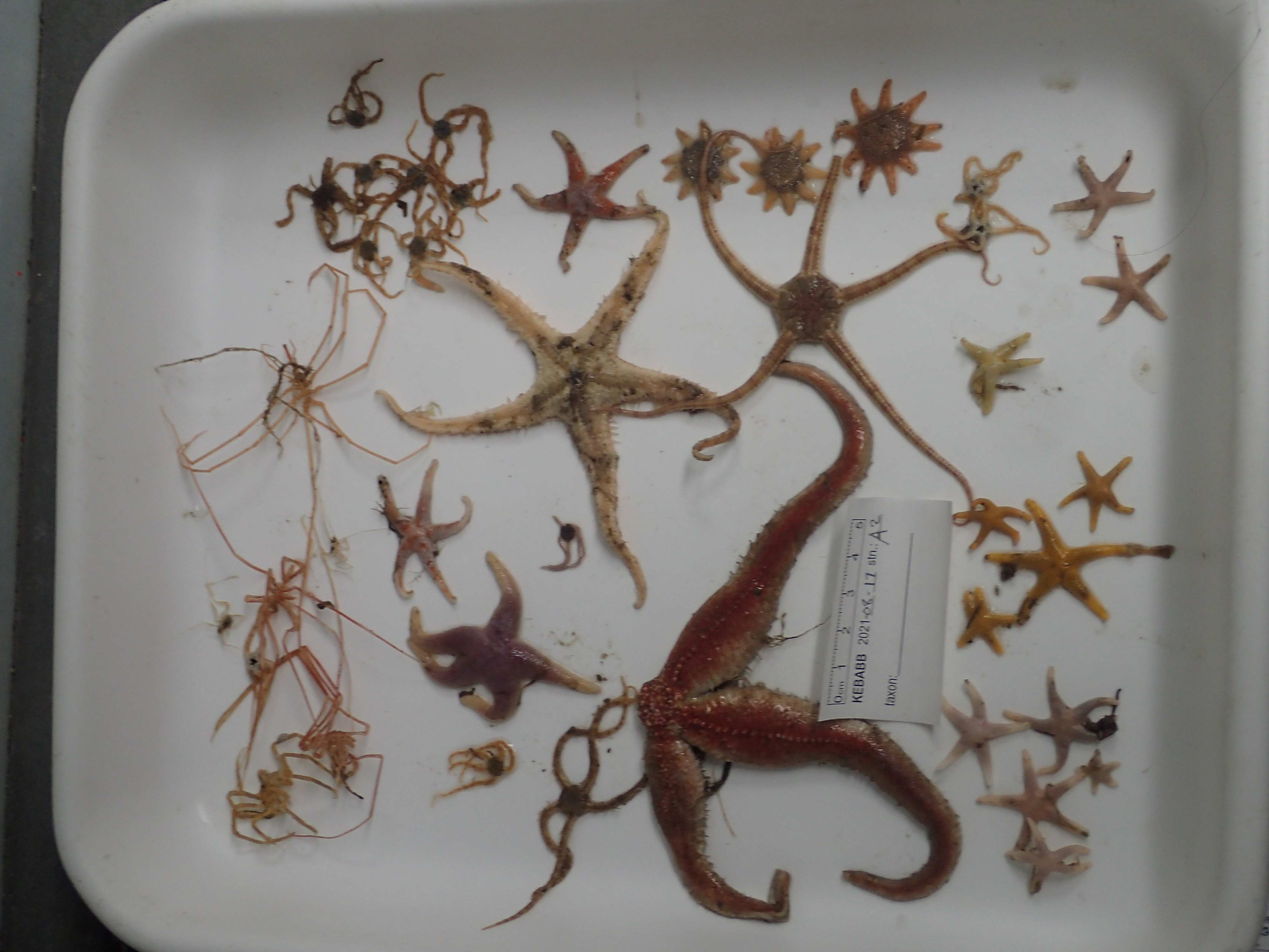
This resource documents a dataset of epifauna occurrences collected in 2021 during The Knowledge and Ecosystem-Based Approach in Baffin Bay (KEBABB) program developed by the Department of Fisheries and Oceans Canada (DFO) in collaboration with university partners. The overall objective of KEBABB is to characterize the variability and trends in physical, chemical, and biological oceanographic conditions and food webs supporting fisheries in the connected ecosystems of western Baffin Bay and Lancaster Sound. In 2021, DFO expanded the KEBABB program to Barrow Strait (KEBABS-Knowledge and Ecosystem-Based Approach in Barrow Strait), a key productive area of the Tallurutiup Imanga National Marine Conservation Area. The study took place in the Eastern Canadian Arctic (mainly in Baffin Bay, Davis Strait and Barrow Strait). Sampling is done along transects at fixed stations in the study area. Catches are collected with a 1.5 m Agassiz trawl (5 mm mesh net) for 3 minutes bottom-contact time at a target speed of 1.5 knots and with a 3 m benthic beam trawl (6.4 mm mesh net) for 15 minutes bottom-contact time at a target speed of 3 knots. A total of 16 stations were sampled for epifauna in 2021 between 85-850 m depth. Epibenthic invertebrates are identified to the lowest possible taxonomic level and photographed. All unknown specimens are frozen. In the lab, the identifications are validated or refined with the photos and the frozen specimens. The data are presented in Darwin Core and are separated in two files: The “Activité_épifaune_KEBABB_epifauna_event_en” file which contains information about missions, stations and deployments, which are presented under a hierarchical activity structure. The “Occurrence_épifaune_KEBABB_epifauna_en” file that contains the taxonomic occurrences. Further details on sampling can be found in the following report: Pućko, M., Charette, J., Tremblay P., Brulotte S., St-Denis B., Ciastek S., Hedges, K., Kuzyk, Z., Roy V., and Michel, C. 2022. An ecosystem-based approach in the eastern Arctic: KEBABB/S (Knowledge and Ecosystem-Based Approach in Baffin Bay/Barrow Strait) 2021 expedition report. Can. Manuscr. Rep. Fish. Aquat. Sci. 3250: viii + 58 p. https://publications.gc.ca/collections/collection_2022/mpo-dfo/Fs97-4-3250-eng.pdf USE LIMITATION: To ensure scientific integrity and appropriate use of the data, we would encourage you to contact the data custodian.
-

This dataset is derived from analyses of photo samples obtained by deploying drop camera photo (DCP) systems conducted during various research surveys in coastal areas of the north shore of the St. Lawrence Estuary and the Gulf between Portneuf-sur-Mer and Sept-Îles between June and October of 2019 to 2022. It contains 4866 species occurrence data of 109 different taxa for epibenthic invertebrates and submerged aquatic vegetation (including algae) at depths ranging from 0 to more than 50 meters. Additional information about this dataset is available in the “Method step description” section. The research surveys were undertaken by the Department of Fisheries and Oceans Canada as part of the baseline program of the Ocean Protection Plan. This initiative aims to acquire environmental baseline data contributing to the characterization of important coastal areas and to support evidence-based assessments and management decisions for preserving marine ecosystems. Data acquired during the research surveys additionally include: 1) fish and invertebrate species occurrence data derived from analyses of video samples collected using a stereoscopic baited remote underwater camera video systems (stereo-BRUVs) 2) fish and invertebrates catch data from beam trawl sampling (occurrence and catch weights by species), 3) substrate classification based on drop camera samples, 4) oceanographic measurements of the water column from Seabird 19plus V2 profiling CTD (conductivity, temperature, depth, photosynthetic active radiation, pH, dissolved oxygen), 5) nutrients (NO2, NO3, NH4, PO4, SiO3) and dissolve organic carbon (DOC) concentrations, and 6) current speed and direction from tilt meters. The datasets of the first two elements will also be available as independent datasets on the OBIS/GBIF portal. To obtain data from items 3-6 and/or biological data collected on fish and invertebrate taxa, please contact David Lévesque or Marie-Julie Roux. The elaboration of conservation objectives based on an ecosystem assessment approach for fishery stock assessment requires the development of sampling methods to maximize the data collection on the ecosystem, while minimizing the impact on organisms and the marine environment. This project aims at characterising the coastal ecosystem of the St. Lawrence Estuary and Gulf between Portneuf-sur-Mer and Sept-Îles (QC), including the physico-chemistry of water, phytoplankton, zooplankton, submerged vegetation, benthic habitats as well as assemblages of fish and invertebrates. Sampling was performed by combining conventional methods such as CTD profiling, zooplankton nets, and beam trawl, with non-extractive methods such as drop camera photo (DCP) and stereoscopic baited remote underwater camera video systems (stereo-BRUVs). The data collected will help define baseline ecosystem conditions in the study area; explore the links between environmental conditions, habitat structure and biological assemblages; identify important habitats for marine species; as well as the evaluation of the performance of visual sampling methods compared to conventional methods. The results will make it possible to optimize the seasonal or annual monitoring in order to better understand the direct and indirect effects of human activities in coastal environments. Method Step Description: 1. Acquisition of photo samples in sequence: The drop camera photo (DCP) system used to sample underwater pictures is a stainless steel frame in the shape of a triangular prism of 50 cm wide, 100 cm long and 76 cm high at the level of the central eyelet. The sampling area is a quadrat of 0.25 m2 (interior dimensions of 50 cm by 50 cm). The system consists of two GoPro Hero 5 cameras (4000 × 3000 pixels) and two 8000 lumens dive lights (Big Blue VL8000). The first camera captures the elements located in the quadrat when viewed from above. The second camera offers an oblique view facilitating the evaluation of the elements present in the quadrat. At all sampling stations, five to nine system deployments (replicas) capturing photos every 10 seconds for 60 to 120 seconds were performed. Surveys took place between : June 28th to July 5th 2019 July 13th to July 20th 2019 September 30th to October 9th 2019 August 10th to August 20th 2020 October 1st to October 10th 2020 April 22nd to May 5th 2021 July 27th to August 10th 2021 October 15th to October 24th 2021 June 24th to Jully 5th 2022 August 15th to August 26th 2022 2. Image analysis: A photo image analysis method with sequence (moving images) was used for the occurrence data extraction and organism counts; measurements were taken to obtain vegetation cover percentages and substrate analyzes were also carried out. Analyzes were performed with the open-source Fiji software from ImageJ. A quality/visibility rating was assigned to the analyzed image sequences. 3. Taxonomic approach: Epibenthic organisms were identified at the lowest possible taxonomic rank. A morphotype approach has been systematically used (during annotations) for the identification of sponges, hydrozoans and bryozoans, and occasionally for other organisms such as algae. Species codes were also used to distinguish certain species that could not be identified at the time of the annotations (see verbatim Identification). To eliminate observer bias, the same person analyzed all images used in this database. The organisms were identified from underwater images using a combination of identification guides and scientific papers. 4. Open nomenclature: The concept of open nomenclature has been integrated into occurrence data to support taxonomic identifications with their level of certainty, as recommended by Horton et al., 2021. The abbreviation stet. (stetit) was used when the decision not to go lower was made but an identification might be possible, whereas indet (Indeterminabilis) was used when a lower level identification was considered uncertain or impossible (see identificationqualifier). In addition, the abbreviation Confer (cf.) was used and integrated into the data tables (see occurrenceRemarks) in order to link identifications that could potentially and/or possibly be associated. 5. Remarks: Several remarks have also been incorporated (see organismRemarks, identificationRemarks and taxonRemarks), and are intended to provide additional information that may be useful to some data users; Please note that these sections could be modified or improved. 6. Quality control: The taxonomic identifications were verified through a validation process, in collaboration with various expert taxonomists. All scientific names have been checked against the World Register of Marine Species (WoRMS) to match currently recognized standards. The WoRMS match was placed in the taxonID field of the instance file. Data quality control was performed using Robistools and worms packages. All sample locations were plotted on a map for visual verification that the latitude and longitude coordinates were within the described sample area. 7. Data sharing: Only metadata and biodiversity occurrence data are shared in this dataset. The two files provided (DarwinCore format) are complementary and are linked by the "eventID" key. The "event" file includes generic event information, including date and location. The "occurrence" file includes the original identifiers of the observed organisms, identification comments and their taxonomy. A data dictionary is also provided to explain the fields used. For access to other data or images, contact David Lévesque. For more details about the project and the methodology, a technical report (Scallon-Chouinard et al., 2022) including sampling methods with drop camera photo systems (DCP) and stereoscopic baited remote underwater camera video systems (stereo-BRUVs) is currently available online (https://waves-vagues.dfo-mpo.gc.ca/library-bibliotheque/41081225.pdf); another technical report detailing photo and video image analysis methods will also be available. This project was funded by the Department of Fisheries and Oceans Canada as part of the baseline program of the Ocean Protection Plan.
-

Fisheries and Oceans Canada (DFO) selected the Manicouagan Peninsula area as a site of interest for the possible establishment of a Marine Protected Area (MPA) in 1998. With this in mind, DFO conducted surveys to assess benthic biodiversity between 2006 and 2008. During the various campaigns, more than a hundred stations were sampled using various tools to target epibenthic and endobenthic species. Various tools were used during the three years of sampling, including an SM (Smith-McIntyre) grab with an area of 0.1 m² and a height of 20 cm, an IKU-type grab with a surface area of 1.5 m² and a height of 50 cm, and a hydraulic dredge measuring 1.36 m wide and 0.66 m high with a net mesh size of 2.3 cm. As the dredge clogged fairly quickly, small organisms were collected in abundance. In 2006 and 2007, a camera mounted on a sled pulled by a boat along transects of varying lengths depending on the sampling campaign collected images (3,008 x 2,000 pixels) every 10 seconds, representing a seabed area of 40 x 40 cm. The data are presented in Darwin Core format in the file “donnees_manicouagan_data” The available data include taxonomic identifications of samples (individuals collected or identified in images) as well as metadata related to stations, including sampling date, depth, and geographic coordinates. Please note that the depths are for informational purposes only, since the bathymetry is very steep in this region. Further details on sampling can be found in the following report: Provencher, L et Nozères, C. 2011. Protocole de suivi des communautés benthiques de la zone de protection marine Manicouagan. Secr. can. de consult. sci. du MPO. Doc. de rech. 2011/051. iv +25 p. https://waves-vagues.dfo-mpo.gc.ca/library-bibliotheque/344357.pdf
-

Monitoring of Unit 2 redfish by Fisheries and Oceans Canada (DFO) ceased in 2002. Since then, the Atlantic Groundfish Council (AGC, formerly the Groundfish Enterprise Allocation Council [GEAC]) has funded surveys approximately every two years in the area, in collaboration with DFO. Over the years, various vessels and gear types have been used. In 2024, a comparative survey was conducted using the CCGS John Cabot and a fishing industry vessel (the Léry Charles) to develop conversion factors that allow data from the 2020, 2022, and 2024 Unit 2 redfish surveys to be standardized to CCGS John Cabot equivalents. The survey covered the waters off southwestern Newfoundland and eastern Cape Breton, corresponding to redfish management Unit 2, which includes NAFO subdivisions 3Pn, 3Ps, 4Vn, 4Vs, and 4W. Here, data collected aboard the CCGS John Cabot are presented. Objectives • Assess the abundance and condition of groundfish and invertebrates • Assess environmental conditions • Inventory the biodiversity of benthic and demersal megafauna • Monitor the pelagic ecosystem • Collect samples for various research projects Data The CCGS John Cabot employed a four-sided modified Campelen 1800 shrimp trawl, fitted with a Rockhopper ("bicycle") footgear. The trawl extension and codend were lined with 12.7 mm knotless nylon mesh. Standard trawl tows were 15 minutes in duration, timed from bottom contact, with a target towing speed of 3 knots. For each fishing tow, the catch is sorted and weighed by taxa; individuals are then counted and biological data are collected on a subsample. For fish, crab and squid, size and weight are measured by individual and, for some species, sex, gonad maturity, and the weight of certain organs (stomach, liver, gonads) are also evaluated. The soft rays of the anal fin are counted for redfish, and the otoliths are sampled for several species such as Atlantic cod, Atlantic halibut, and Greenland halibut. Roughly 2-kg of shrimp are sorted and weighed by species. The other invertebrates are counted (no individual measurements) and photographed. The biological data are divided into 3 files: a “Stations” file containing set information, a “Catches” file containing catches per set for all species caught and a “Carbio” file containing biological and morphometric measurements per individual all species measured except shrimps. The columns source_info, no_survey, nbpc and station_number serve as a common key linking the three datasets. To further link the “Captures” and the “Carbio” files to the species level (for fish and certain invertebrate species), use the columns source_info, no_survey, nbpc, station_number, strap_code, and category. Further shrimp biological and morphometric data are available but are not presented here in order to simplify data presentation. For access to the complete information, please contact the data management team (gddaiss-dmsaisb@dfo-mpo.gc.ca). The latest published data is preliminary and will be updated at the end of January of the following year. It is important to note that this is raw data. Only sets considered successful are retained. In each set, all species are kept, with a few exceptions. Data is available from 1997-2022 but please contact the data management team (gddaiss-dmsaisb@dfo-mpo.gc.ca) for access and further details. For any other information please also contact the data management team.
-

The Planning for an Environmental Response (PIER) initiative falls under the umbrella of the Government of Canada’s Oceans Protection Plan (OPP), whose goal is preserving marine ecosystems vulnerable to increased transportation and the development of the marine industry. The PIERs’ main mandate is to acquire and update biological sensitivity data under its jurisdiction for preparation and response purposes in the event of an oil spill. This dataset contains all observations of marine organisms noted during the analysis of 2959 underwater images sampled over a large extent of the coastal zone (≤10 m) of the Estuary and the Gulf of St. Lawrence (Quebec region). The dataset includes 21 490 occurrences of 150 taxa and informal categories including macroalgae, invertebrates and fish. Underwater images were collected between 2017 and 2021 according to a directed sampling protocol whose primary goal was to map large seaweed and eelgrass beds. Images were normally recorded as videos using a GoPro Hero camera installed on a pole and placed near the seabed from a small boat. The collected data served primarily as ground-truth data to validate coasting zone mapping based on aerial photographs within the framework of the PIER's initiative. The two files provided (DarwinCore format) are complementary and are linked by the "eventID" key. The "event_information" file includes generic event information, including date and location. The "taxon_occurrence" file includes the original identifiers of the observed organisms (verbatimIdentification field), identification remarks and their taxonomy. Taxonomic names were verified on the World Register of Marine Species (WoRMS) to match recognized standards. The WoRMS match has been put in the scientificNameID field in the occurrence file. Data quality control was performed using the R packages obistools and worrms. All sampling locations were plotted on a map to perform a visual check confirming that the latitude and longitude coordinates were within the described sampling area. A visual dictionary was developed as an identification aid and accompanies this dataset (unilingual french only, the English version will be published soon). More data, including a visibility index, estimated macroalgae and eelgrass cover, substrate type and dominant macroalgae and animals were recorded but not included in this dataset. These data may be made available upon request. Credits Provencher-Nolet, L., Paquette, L., Pitre, L.D., Grégoire, B. and Desjardins, C. 2024. Cartographie des macrophytes estuariens et marins du Québec. Rapp. Tech. Can. Sci. halieut. Aquat. 3617 : v + 99 p. Grégoire, B., Pitre, L.D., Provencher-Nolet, L., Paquette, L. and Desjardins, C. 2024. Distribution d’organismes marins de la zone côtière peu profonde du Québec recensés par imagerie sous-marine de 2017 à 2021. Rapp. tech. can. sci. halieut. aquat. 3616 : v + 78 p.
-

The Planning for an Environmental Response (PIER) initiative falls under the umbrella of the Government of Canada's Oceans Protection Plan (OPP), whose goal is preserving marine ecosystems vulnerable to increased transportation and the development of the marine industry (https://pm.gc.ca/en/news/backgrounders/2016/11/07/canadas-oceans-protection-plan-preserving-and-restoring-canadas). The PIER was established in response to recommendations made in a 2013 report "A review of Canada's ship-source spill preparedness and response regime " by the Tanker Safety Expert Panel (https://tc.canada.ca/en/marine-transportation/marine-safety/tanker-safety-expert-panel). One of the recommendations calls on Fisheries and Oceans (DFO) to work with Environment and Climate Change Canada (ECCC) to collect and compile information on sensitive species and environments for each Canadian Coast Guard (CCG) response area and make it publicly available. The PIERs’ main mandate is to acquire and update biological sensitivity data under its jurisdiction for preparation and response purposes in the event of an oil spill. With DFO-Science, PIER supports ECCC's National Environmental Emergencies Centre (NEEC) and the CCG in their preparations and responses through the sharing of data on biological sensitivities, the development of response tools and expert advice. In this vein, DFO published an analysis in 2018 that aimed to identify the most vulnerable components of the St. Lawrence in order to prioritize them during data collection if gaps were identified (Desjardins et al. 2018). This exercise highlighted the vulnerability of several biological components and important data gaps, particularly in coastal areas. As a result of this finding, the Quebec region PIEI team embarked on a collaborative project with the Université du Québec à Rimouski (UQAR) to map eelgrass beds, tidal marshes and macroalgal beds. In consultation with other DFO-Science data producers, this team has also created datasets adapted for response purposes, notably regarding bivalves and marine mammals. These layers may be used for oil spill preparedness and response by DFO-Quebec Region's Environmental Incident Coordinator, NEEC and CCG. Several of them, deemed relevant in the first 72 hours following a spill, have been transmitted to the NEEC.
-
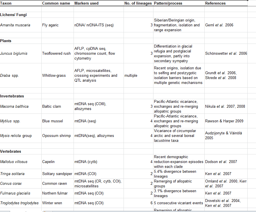
Appendix 17.2. Cryptic speciation in selected Arctic terrestrial and marine species.
-

An exploratory project on the taxonomic and genetic diversity of decapods in three ocean subregions (Northeast Pacific, Canadian Arctic, and Northwest Atlantic), which were sampled in 2022, was undertaken by the Arctic Working Group under the Canada-U.S. Fisheries and Climate Collaboration between Fisheries and Oceans Canada (DFO) and the National Marine Fisheries Service (NMFS) of the National Oceanic and Atmospheric Administration (NOAA). This collaboration framework aims to pool Canadian and U.S. data to explore the impacts of broad-scale climate change on marine biodiversity. In early summer 2022, a sampling protocol with the selection of targeted decapods was provided to DFO and NOAA collaborators. Targeted genera were collected from a total of 10 research programs across three ocean subregions and four marine regions. The Northeast Pacific samples were collected in the Bering Sea during the Northern Bering Sea Ecosystem and Surface Trawl Survey, and the Eastern and Northern Bering Sea Continental Shelf Bottom Trawl Survey of Groundfish and Invertebrate Fauna onboard the F/V Northwest Explorer, F/V Alaska Knight and F/V Vesteraalen. In the Western Canadian Arctic (mainly from Beaufort Sea and Amundsen Gulf), specimens were collected during DFO’s Canadian Beaufort Sea – Marine Ecosystem Assessment (CBS-MEA) survey onboard the F/V Frosti. In Eastern Canadian Arctic (mainly from Baffin Bay and Davis Strait), specimens were collected during DFO’s Knowledge and Ecosystem-Based Approach in Baffin Bay (KEBABB) survey onboard the CCGS Amundsen and DFO’s North Atlantic Fisheries Organization (NAFO) Subarea 0B survey onboard the R/V Tarajoq. In the Estuary and Gulf of St. Lawrence (EGSL), specimens were collected from coastal surveys (scallops, sea cucumber, snow crab, and whelk surveys) onboard the CCGS Leim and offshore during the Ecosystemic Survey onboard the CCGS Teleost. Decapods were collected from various sampling gears (benthic beam trawl, modified Atlantic Western IIA otter trawl, Bacalao trawl, shrimp trawl, Digby scallop dredge, or modified sea cucumber dredge) and identified to the lowest possible taxonomic level and photographed, when possible. All specimens were frozen at sea (n = 995). In the lab, the identifications were validated or refined with the photos and the frozen specimens. DNA was extracted for 87 specimens and a section of COI gene was amplified in order to be sequenced using Sanger method. Sequences were compared with existing data using The Basic Local Alignment Search Tool (BLAST) in the National Center for Bio-technology Information Nucleotide database (NCBI-nt, including the GenBank database) to compare scientific names, where available. The present dataset includes 391 decapod species occurrences. DNA was extracted for a subset of 87 specimens (COI gene); sequences are publicly available on BOLD data portal under project code DDAO (see supporting document "citations_references.csv" for more information). The data are presented in Darwin Core format and are separated in three files: The "Activité_décapodes_DDAO_decapods_event_en" file contains information about missions, stations and deployments, which are presented under a hierarchical activity structure. The "Occurrence_décapodes_DDAO_decapods_en" file contains the taxonomic occurrences. The "ADN_décapodes_DDAO_decapods_DNA_en" file contains the DNA derived data. For further details, please refer to the technical report available in the supporting document named "citations_references.csv". USE LIMITATION: To ensure scientific integrity and appropriate use of the data, we would encourage you to contact the data custodian.