 Arctic SDI catalogue
Marine Conservation Target
Type of resources
Topics
Keywords
Contact for the resource
Provided by
Formats
Representation types
Update frequencies
status
-

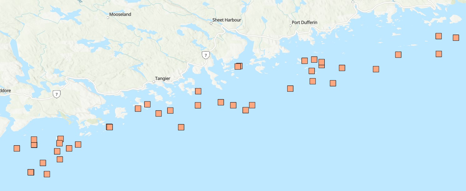
Funded under DFO's Marine Conservation Targets Program, this optical imagery benthic survey captured 73 drift-camera transects from September 21, 2022 to October 3, 2024 in the Fundy Isles region of the lower, western Bay of Fundy, New Brunswick, Canada. The survey area includes the 'Head Harbour/West Isles Archipelago/The Passages' Ecologically and Biologically Significant Area (ESBA, ~113 km2), the Wolves Islands and Grand Manan Island. High-resolution still images (n=5081) were taken periodically throughout each transect, while continuous high-definition downward- and forward-facing video (~30 hours of each) was collected simultaneously. Distance travelled and distance between still images (m) was calculated using ArcGIS tools. Field of view (FOV) was estimated by measuring the length and width of a subset of still images (n=863) in ImageJ2, using 10-cm lasers for scale. FOV was standardized for each reported altitude. Transects ranged from 133 m to 2.6 km in length (~47 km surveyed in total), collecting imagery continuously for 3 minutes to more than 1 hour at a time, surveying depths from 15 to 188 m below chart datum. Transect locations were selected based on unique bathymetric features, areas previously predicted to have high habitat suitability for vulnerable marine ecosystem species, as well as proposed areas for inclusion in the regional marine conservation network plan. Additional information and imagery pertaining specifically to the 2022 datasets can be found at the following link in the Open Government Portal: https://open.canada.ca/data/en/dataset/8ea6c28a-3d6c-47ef-8cf7-56790ee0c7f5 Cite this data as: Lawton P, Teed L. Near-seafloor drift transect video and high-resolution digital still imagery from a three-year survey in the Fundy Isles region of the lower, western Bay of Fundy. Published November 2025. Coastal Ecosystems Science Division, Fisheries and Oceans Canada, St. Andrews, N.B.
-
Funded under DFO's Marine Conservation Targets Program in partnership with the Huntsman Marine Science Centre (HMSC), this diver-based imagery and sample collection benthic survey documents the occurrence of sponges at 42 dive sites in the Eastern Shore Islands (ESI) Area of Interest (AOI, ~2089 km2) off the Atlantic coast of Nova Scotia, Canada from dive surveys conducted in summer 2021 and 2022. Water quality, species occurrences and counts, habitat, slope, and substrate characteristics were catalogued through diver log sheets, camera imagery, specimen vouchers, and high-resolution bathymetric data. A total of 54 dives to depths from 11 to 33 m (below sea level), collecting up to 147 still images, one-hour of video, and 17 specimen samples per site, resulted in 220 observations for 27 different sponge taxa. This included three new records for Canada (Hymedesmia stellifera, Plocamionida arndti, Hymedesmia jecusculum) and a range extension for a species new to science (Crellomima mehqisinpekonuta) which was recently described from the Bay of Fundy. There were also four species which may seem to be new to science (Halichondria sp., Hymedesmia sp., Protosuberires sp., and Sphaerotylus sp.). Sponges were found to occupy a diversity of micro-habitats, often several different ones in proximity. A total of eight distinct habitat classes were defined, based on varying abundances and diversity of sponges and associated benthic species. These are likely widely distributed among the many complex submerged seabed features within this AOI. Collected specimens were preserved and are stored at the Atlantic Reference Centre (ARC) in St. Andrew's, New Brunswick. Cite this data as: Goodwin, C., Cooper, J.A., Lawton, P., Teed, L.L. 2025. Sponge occurrence and associated species and habitat descriptions derived from the 2021 and 2022 SCUBA diving surveys in the Eastern Shore Islands Area of Interest, Nova Scotia. Version 1.4. Fisheries and Oceans Canada. Occurrence dataset. https://ipt.iobis.org/obiscanada/resource?r=eastern_shore_islands_sponge_survey_2021_2022&v=1.4
-
The Eastern Shore Islands Area of Interest (AOI) is a large coastal AOI in the Maritimes Region spanning 2089 km2 and extending along 100 km of coastline. While much of the data that led to the area's designation as an AOI was collected in the nearshore coastal areas (i.e., seagrass and kelp distributions, coastal bird nesting sites, herring spawning areas), there is less information available on the fish and invertebrate community structure in offshore areas of the AOI. Current offshore sampling effort is primarily focused in the Summer multi-species RV survey which covers the Scotian Shelf but does not sample within the depth range covered by the AOI (~ <100m depth). Environmental DNA (eDNA) offers a promising approach for biodiversity monitoring that has been gaining increased attention in the marine realm. Through sampling relatively small volumes of water (~1-5 L), eDNA can capture of millions of fragments of eDNA on filters that can then be sequenced to identify the species composition of an area. eDNA metabarcoding is based on the foundations of DNA barcoding, where species are identified solely by their unique DNA sequences. eDNA metabarcoding relies on a comprehensive reference library of gene sequences from known species to rapidly identify which species are captured in every water sample. This method is relatively simple, efficient (with the ability to characterize both fish and invertebrate diversity), and non-invasive, meaning there is no disruption of sensitive benthic habitats or need to dissect tissue samples from captured fish and invertebrates. eDNA has been shown to be comparable to other biodiversity censusing techniques and has the potential to rapidly conduct biodiversity surveys over a relatively large area, such as the Eastern Shore Islands AOI. Our eDNA sampling in the Eastern Shore Islands targets fish and invertebrates using multiple genetic markers (e.g., 12S and COI) to obtain baseline information on these communities across transects spanning from inshore to offshore in the AOI. Over time, we will investigate changes in species richness and community composition using annual eDNA surveys as an ongoing monitoring tool for this coastal region. Cite this data as: Jeffery, N.W. Environmental DNA Monitoring in the Eastern Shore Islands Area of Interest - Offshore. Published: April 2026. Coastal Ecosystems Science Division, Maritimes Region, Fisheries and Oceans Canada, Dartmouth NS.
-

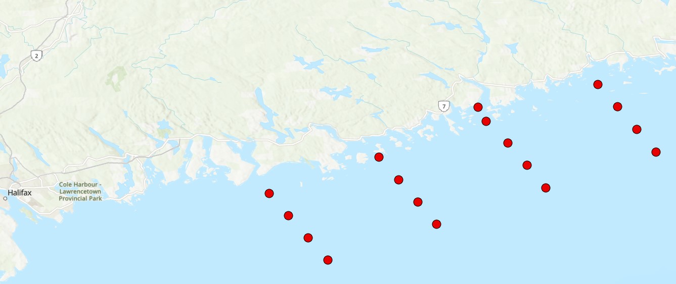
Funded under DFO's Marine Conservation Targets Program, this two-year optical imagery benthic survey captured 41 drift-camera transects in the St. Anns Bank Marine Protected Area (MPA - 4364 km2) and 4 coastal transects west of the MPA, Atlantic Canada from August 15-23, 2023 and August 08-17, 2024. High-resolution still images (n=3605) were taken periodically throughout each transect, while continuous high-definition downward- and forward-facing video (~20 hours of each) was collected simultaneously along with over 14 hours of forward-facing Go-Pro video (only in 2024). Transect and image locations were collected using an acoustic positioning operating system (Kongsberg APOS) acquired in 2024; year-one of the survey relied on the vessel position. Distance travelled and distance between still images (m) was calculated using ArcGIS tools. Field of view (FOV) was estimated by measuring the length and width of a subset of still images from year-one of the survey (n=500) in ImageJ2, using 10-cm lasers for scale. FOV was standardized for each reported altitude. Transects ranged from 319 m to 2.8 km in length (~47 km surveyed in total), collecting imagery for 12 minutes to just over 1 hour at a time, surveying depths from 17 to 144 m below chart datum. Transect locations were selected based on unique bathymetric features and benthoscapes as well as areas previously surveyed from 2009-2015. Cite this data as: Lawton P, Teed L. Near-seafloor drift transect video imagery and high-resolution digital still images from a two-year survey in support of Marine Protected Area monitoring of St. Anns Bank, Atlantic Canada. Published January 2025. Coastal Ecosystems Science Division, Fisheries and Oceans Canada, St. Andrews, N.B.
-

Funded under DFO's Marine Conservation Targets Program, this optical imagery benthic survey documents the occurrence and estimated percent cover of the invasive colonial tunicate, Didemnum vexillum in seven drift-camera transects in the 'Head Harbour/West Isles Archipelago/The Passages' Ecologically and Biologically Significant Area (ESBA, ~113km2) in the western Bay of Fundy, New Brunswick, Canada. Occurrence data was derived from the use of high-resolution still images (n=386) taken periodically throughout each transect, and simultaneous continuous high-definition video. Video was divided into 20-second segments (here, we report the start and end location of each segment within a transect) and when D. vexillum was present in a video segment, frequency of occurrence was classified as common (continuous coverage/patches throughout the video segment), occasional (individual colonies of various sizes encountered >5 times throughout the video segment), or rare (small, isolated colonies encountered ≤5 times throughout the video segment). A video segment was deemed unusable and removed from the dataset if there was too much turbidity, or if the camera position was too high off-bottom to reliably image the seafloor. For still images, when D. vexillum was observed in an image, colony percent cover was categorized as >50%, 26-50%, 6-25%, or ≤5% of the images field of view (FOV). Distance travelled and distance between still images (m) was calculated using ArcGIS tools. FOV was estimated by measuring the length and width of a subset of still images and video frame grabs in ImageJ2, using 10-cm lasers for scale. FOV was standardized for each reported altitude, and area sampled (m2) along a continuous video segment was estimated by multiplying the average FOV by the distance travelled in that segment. D. vexillum was found in 44% of the area sampled at depths from 34 to 118m, deeper than previous reports globally of ~80m. Cite this data as: Teed LL, Goodwin C, Lawton P, Lacoursière-Roussel A, Dinning KM (2024) Multiple perspectives on the emergence of the invasive colonial tunicate Didemnum vexillum Kott, 2002 in the western Bay of Fundy, Atlantic Canada. BioInvasions Records 13(3): 713–738, https://doi.org/10.3391/bir.2024.13.3.12
-

We evaluated an autonomous environmental DNA sampler produced by Dartmouth Ocean Technologies Inc (Dartmouth, Canada) compared to time-at-sample filtration in the laboratory to determine the performance of moored samplers for monitoring in the marine world. We deployed three autonomous samplers from DOT in the Bedford Basin (Canada) over a nine-week period in summer/fall 2023. The samplers filtered seawater in situ at programmed interviews over this time period, and we collected contemporaneous samples with a standard vacuum pump during each sampling period. Both eDNA sample types captured similar fish diversity, including typical diversity for the Northwest Atlantic. The invertebrate community detected using the COI marker was different between each sample type, likely due to differences in filter pore size. We found biofouling on the moored samplers was minimal over the study period, even in a high-traffic area such as the Bedford Basin, likely due to the relatively short experimental period, and copper screening covering in the inlet and outlet valves of the instruments. Overall, our results show promise to deploy autonomous eDNA samplers in marine conservation areas to contribute to monitoring in the temperate ocean, but further testing over longer periods of time is needed to determine if DNA remains well-preserved in the autonomous samplers at ambient ocean temperatures. Cite this data as: Jeffery, N.W., Van Wyngaarden, M., and Stanley, R.R.E. Evaluating an Autonomous eDNA Sampler for Marine Environmental Monitoring: Short- and Long-Term Applications. Published: December 2024. Coastal Ecosystems Science Division, Maritimes Region, Fisheries and Oceans Canada, Dartmouth NS.
-
DFO has committed to establishing a representative network of Marine Conservation Areas collectively comprising 30% of the EEZ by 2030. The MCT 2.0 program was established in 2021 to help achieve this target and establish long-term monitoring within Canadian conservation areas. Information on the distribution of species within a protected area is essential for the management and monitoring of a site. Decisions made on zoning, risk assessment, activity approvals and management effectiveness all require information on the distribution and status of species. The Scotian Shelf-Bay of Fundy Bioregion spans the domain of the Maritimes Region, and within it there are 8 Marine Refuges (MR), 3 Marine Protected Areas (MPA), and 2 Areas of Interest (AOI). Environmental DNA (eDNA) offers a promising approach for biodiversity monitoring that has been gaining increased attention in the marine realm. Through sampling relatively small volumes of water (~3L), eDNA can capture of millions of fragments of eDNA on specialized filters that can then be sequenced to identify the species composition of an area. eDNA metabarcoding is based on the foundations of DNA barcoding, where species are identified solely by their unique DNA sequences. This method is relatively simple, efficient (with the ability to characterize both fish and invertebrate diversity), and non-invasive, meaning there is no disruption of sensitive benthic habitats or need to dissect tissue samples from captured fish and invertebrates. eDNA has been shown to be comparable to other biodiversity censusing techniques and has the potential to rapidly conduct biodiversity surveys over a relatively large area, such as the Eastern Shore Islands AOI. The DFO Maritimes summer multispecies trawl survey is one of the longest-running data series with applications in fisheries stock assessment, and one of the only sources of data for offshore MPA design and monitoring. In this project we pair eDNA samples collected within current and proposed conservation areas with trawl catch data to create a biodiversity and animal community monitoring time series for these areas. We use eDNA and trawl catch data as complementary tools, where trawl-based catch provides information on fish abundance, size distributions and sex, and eDNA provides information on genetic diversity and can detect cryptic and rare species. Cite this data as: Jeffery, N.W. Monitoring regional conservation areas using paired environmental DNA and research trawl surveys. Published: May 2026. Coastal Ecosystems Science Division, Maritimes Region, Fisheries and Oceans Canada, Dartmouth NS.
-

A derivative of DFO's benthic imagery surveys for the Marine Conservation Targets Program in the St. Anns Bank Marine Protected Area (https://open.canada.ca/data/en/dataset/2a55e2b4-cbb6-4fea-b17e-a16f5e99e68f), occurrence records in this analysis represent presence/absence and density of a biogenic habitat-forming species in five drift-camera transects in the southeast corner of the MPA, off the coast of Cape Breton, Nova Scotia, Canada. Presence/absence and count data of the unstalked crinoid (Heliometra glacialis) were derived from the use of high-resolution Nikon D850 still images (n=428, see link to parent record for more descriptive survey information and complete imagery dataset) and continuous high-definition video observations (approximately one observation every second using a 1Cam Mk6, SubC Imaging camera; n=8522). Densities were estimated by dividing the crinoid counts by the field of view (calculated from lasers with 10-cm spacing). Substrates were reported for each video observation, documenting the dominant substrate (>50% cover) according to a modified Wentworth scale (i.e., sand, gravel, pebble, cobble, boulder, bedrock; Wentworth 1922). Crinoids were observed in ~44% of the area of the five transects (~4811 m2), forming dense beds along sloped features from 77-119-m depths, predominantly on cobble and pebble substrates, reaching densities of up to 59 ind. m-2 and 139 ind. m-2 in the digital still images and video observations, respectively. Cite this data as: Lawton P, Teed L. Fine-scale observations of high density Heliometra glacialis (Crinoidea) beds from five near-seafloor imagery transects from a two-year survey in the St. Anns Bank Marine Protected Area, Atlantic Canada. Published March 2026. Coastal Ecosystems Science Division, Fisheries and Oceans Canada, St. Andrews, N.B. References: - Wentworth, C.K. 1922. A scale of grade and class terms for clastic sediments. The Journal of Geology 30(5): 377-392.
-

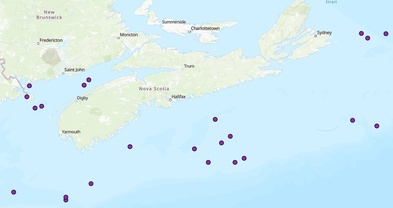
To assess the current distribution of kelp beds and other macroalgae in Nova Scotia and Southwest New Brunswick, subtidal drop camera surveys were performed from 2022-2023 at 140 sites. For each site, a GoPro HERO 10 camera was towed along a deep (7-12m) and shallow (3-5m) depth contour until 20 images were acquired per depth. Where possible, species were identified from photos, with particular care given to kelps (defined here as orders Laminariales and Tilopteridales) and fucoids (order Fucales). Crust-forming algae was not counted. Percent cover was calculated using a 10x10 point grid overlaid on each image and recording the dominant cover type at each point. The depth (in meters) of each photo after correcting for tide height ranged from ~0.5m to ~12m. Depths were corrected to chart datum (lowest astronomical tide) using tide predictions from the nearest tide station, taken from tides.gc.ca. Sampling was performed between July and October. Cite this data as: Krumhansl K, Brooks C, Lowen B, DiBacco C, (2025). Camera Surveys of the Subtidal Flora of Nova Scotia and Southwest New Brunswick 2022-2023. Version 1.7. Fisheries and Oceans Canada. Samplingevent dataset. https://ipt.iobis.org/obiscanada/resource?r=camera_surveys_of_the_subtidal_flora_of_nova_scotia_2022-2023&v=1.7 For additional information please see: Krumhansl K.A., Brooks C.M., Lowen B., O’Brien J., Wong M., DiBacco C. Loss, resilience and recovery of kelp forests in a region of rapid ocean warming. Annals of Botany 2024 Mar 8; 133(1):73-92. Brooks C.M., Krumhansl K.A. 2023. First record of the Asian Antithamnion sparsum Tokida, 1932 (Ceramiales, Rhodophyta) in Nova Scotia, Canada. BioInvasions Records 12(3):745-725.
-
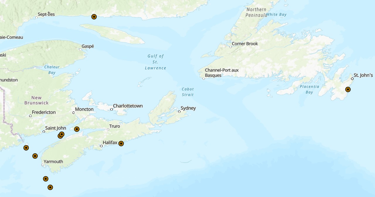
Effective conservation planning relies on understanding population connectivity which can be informed by genomic data. This is particularly important for sessile species like the horse mussel (Modiolus modiolus), a key habitat-forming species and conservation priority in Atlantic Canada), yet little genomic information is available to describe horse mussel connectivity patterns. We used more than 8000 restriction-site associated DNA sequencing-derived single nucleotide polymorphisms and a panel of 8 microsatellites to examine genomic connectivity among horse mussel populations in the Bay of Fundy, along the Scotian Shelf, and in the broader northwestern Atlantic extending to Newfoundland. Despite phenotypic differences between sampling locations, we found an overall lack of genetic diversity and population structure in horse mussels in the Northwest Atlantic Ocean. All sampled locations had low heterozygosity, very low FST, elevated inbreeding coefficients, and deviated from Hardy-Weinberg Equilibrium, highlighting generally low genetic diversity across all metrics. Principal components analysis, Admixture analysis, pairwise FST calculations, and analysis of outlier loci (potentially under selection) all showed no independent genomic clusters within the data, and an analysis of molecular variance showed that less than 1% of the variation within the SNP dataset was found between sampling locations. Our results suggest that connectivity is high among horse mussel populations in the Northwest Atlantic, and coupled with large effective population sizes, this has resulted in minimal genomic divergence across the region. These results can inform conservation design considerations in the Bay of Fundy and support further integration into the broader regional conservation network. Cite this data as: Van Wyngaarden, Mallory et al. (2024). Widespread genetic similarity between Northwest Atlantic populations of the horse mussel, Modiolus modiolus. Published: May 2025. Coastal Ecosystem Science Division, Maritimes Region, Fisheries and Oceans Canada, Dartmouth, NS.