 Arctic SDI catalogue
Marine Habitat
Type of resources
Available actions
Topics
Keywords
Contact for the resource
Provided by
Years
Formats
Representation types
Update frequencies
status
Service types
-

A coastal surficial substrate layer for the coastal Scotian Shelf and Bay of Fundy. To create the layer, previous geological characterizations from NRCan were translated into consistent substrate and habitat characterizations; including surficial grain size and primary habitat type. In areas where no geological description was available, data including digital elevation models and substrate samples from NRCan, CHS and DFO Science were interpreted to produce a regional scale substrate and habitat characterization. Each characterization in the layer was given a ranking of confidence and original data resolution to ensure that decision makers are informed of the quality and scale of data that went into each interpretation. Cite this data as: Greenlaw, M., Harvey, C. Data of: A substrate classification for the Inshore Scotian Shelf and Bay of Fundy, Maritimes Region. Published: March 2022. Coastal Ecosystems Science Division, Fisheries and Oceans Canada, St. Andrews, N.B. https://open.canada.ca/data/en/dataset/f2c493e4-ceaa-11eb-be59-1860247f53e3
-
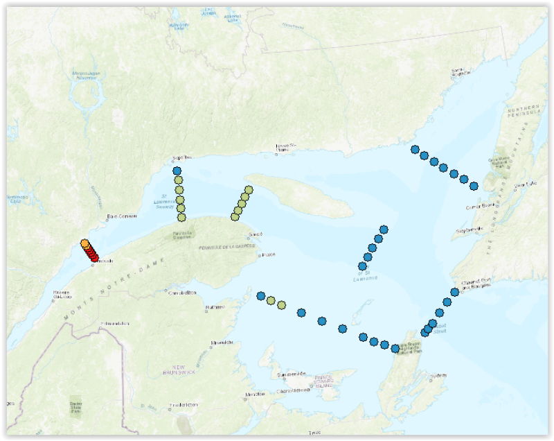
Time series of dissolved inorganic nutrients (nitrate, silicate, phosphate) (mmol/m2) at the 3 fixed stations and 46 stations, grouped into transects, of the Atlantic Zonal Monitoring Program (AZMP) under the Quebec region responsibility. The mean integrated nutrient data of 2 strata (0-50 m) et (50-150 m) from the last ten years are displayed as 12 layers, 6 for the June survey (2013-2022, 2020 not sampled) and 6 for the autumn survey (2013-2022). Finally, 2 other layers shows the positions of the fixed stations of the program (Anticosti Gyre, Gaspé Current and Rimouski). Each station is linked with a .png file showing the time series of nutrients and with a .csv file containing all the integrated nutrient data acquired at those stations since the beginning of the program sampling (columns : Station, Latitude, Longitude, Date(UTC), Sounding(m), Depth_min/Profondeur_min(m), Depth_max/Profondeur_max(m), Integrated_Nitrate/Nitrate_intégré(mmol/m²), Integrated_Phosphate/Phosphate_intégré(mmol/m²), Integrated_Silicate/Silice_intégrée(mmol/m²)). Purpose The Atlantic Zone Monitoring Program (AZMP) was implemented in 1998 with the aim of increasing the Department of Fisheries and Oceans Canada’s (DFO) capacity to detect, track and predict changes in the state and productivity of the marine environment. The AZMP collects data from a network of stations composed of high-frequency monitoring sites and cross-shelf sections in each following DFO region: Québec, Gulf, Maritimes and Newfoundland. The sampling design provides basic information on the natural variability in physical, chemical, and biological properties of the Northwest Atlantic continental shelf. Cross-shelf sections sampling provides detailed geographic information but is limited in a seasonal coverage while critically placed high-frequency monitoring sites complement the geography-based sampling by providing more detailed information on temporal changes in ecosystem properties. In Quebec region, two surveys (46 stations grouped into transects) are conducted every year, one in June and the other in autumn in the Estuary and Gulf of St. Lawrence. Historically, 3 fixed stations were sampled more frequently. One of these is the Rimouski station that still takes part of the program and is sampled about weekly throughout the summer and occasionally in the winter period. Annual reports (physical, biological and a Zonal Scientific Advice) are available from the Canadian Science Advisory Secretariat (CSAS), (http://www.dfo-mpo.gc.ca/csas-sccs/index-eng.htm). Devine, L., Scarratt, M., Plourde, S., Galbraith, P.S., Michaud, S., and Lehoux, C. 2017. Chemical and Biological Oceanographic Conditions in the Estuary and Gulf of St. Lawrence during 2015. DFO Can. Sci. Advis. Sec. Res. Doc. 2017/034. v + 48 pp. Supplemental Information Water sampling for nutrients analysis is done from Niskin bottles according to AZMP sampling protocol: Mitchell, M. R., Harrison, G., Pauley, K., Gagné, A., Maillet, G., and Strain, P. 2002. Atlantic Zonal Monitoring Program sampling protocol. Can. Tech. Rep. Hydrogr. Ocean Sci. 223: iv + 23 pp.
-

Fisheries and Oceans Canada and Environment and Climate Change Canada (Northern Contaminants program) have been working with Nunavut community Hunters and Trappers Organizations and the Nunavut Wildlife Management Board consistently since 1980 to collect samples from harvested ringed seals. The majority of seals were measured in the field by Inuit hunters who recorded date of kill, sex and blubber depth at sternum (0.5 cm). The data from the harvested animals are used to evaluate stressors and overall seal health, in the Canadian Arctic.
-
These datasets represent various marine species whose locations have been identified either via automated satellite tracking of tagged organisms or through direct human observation: surveys (shipborne or aerial), photography, and/or genetic sampling. This can be useful for assessing abundance, population structure, habitat use, and behavior. Each species layer represents a collection of known point locations. Each collection is aggregated from multiple data sources and/or survey periods. Each location contains attributes for further information about the time of the observation and who collected it. These collections are assembled and disseminated at the Pacific Islands Ocean Observing System (PacIOOS). As additional data sources are obtained, these collections may continue to grow over time.
-

Available information for the Estuary and Gulf of St. Lawrence on salinity, temperature, dissolved oxygen, depth, slope, and variability in landscape and sediments, were aggregated using a grid made up of 100 km2 cells as a basis for mapping and describing marine habitats for conservation and integrated management purposes. For example, 26 variables were selected to describe depth, slope, salinity and temperature. Based on that information, cluster analyses were conducted grouping cells into 13 different megahabitats. Four megahabitats described the deep waters, and areas outside channels formed 9 megahabitats: four in the southern Gulf and five in the northern Gulf. Purpose The tool proposes a novel way of making validated and integrated data available to end users. Potential applications include the screening of areas considered for inclusion in a network of protected areas and a quantitative assessment of surface areas for each class of habitat. The method can also be applied to describe the habitats of species at risk. Additional Information See the report mentioned below for a more detailed description of the treatments for each variable: Dutil, J.-D., Proulx, S., Chouinard, P.-M., and Borcard. D. 2011. A hierarchical classification of the seabed based on physiographic and oceanographic features in the St. Lawrence. Can. Tech. Rep. Fish. Aquat. Sci. 2916: vii + 72 p.
-

Basic biological data for all fish caught during the 2012 BSMFP expedition. Includes identification, weight, length (total, fork, and, standard), liver weight, gonad weight, sex and maturity level.
-

PURPOSE: From August 1st to September 11th, 2014, Fisheries and Oceans Canada conducted a baseline survey of marine fishes and their habitats in the southern Canadian Beaufort Sea and Amundsen Gulf as part of the Beaufort Regional Environmental Assessment (BREA) called the Beaufort Sea Marine Fishes Project (BSMFP). Sampling was conducted from the F/V Frosti at 54 stations along 14 transects. Standardized sampling was conducted at pre-determined depth stations (20-1500 m) using benthic trawling nets. The BSMFP is the first research project to use large research trawls to assess the biodiversity and abundance of offshore marine fishes in this area. In total, 42 species of fish were caught. This report contains information on fishing net deployments, catch per unit effort (CPUE), and basic biological data for all fishes caught. DESCRIPTION: Basic biological data for all fish caught during the 2014 BSMFP expedition. Includes identification, weight, length (total, fork, and, standard), liver weight, gonad weight, sex and maturity level. PARAMETERS COLLECTED: family species weight total length fork length standard length liver weight gonad weight sex maturity SAMPLING METHODS: Various trawl types.
-
PURPOSE: From August 2nd to September 9th, 2013, Fisheries and Oceans Canada conducted a baseline survey of marine fishes and their habitats in the southern Canadian Beaufort Sea and Amundsen Gulf as part of the Beaufort Regional Environmental Assessment (BREA) called the Beaufort Sea Marine Fishes Project (BSMFP). Sampling was conducted from the F/V Frosti at 53 stations along 8 transects. Standardized sampling was conducted using benthic trawling nets. The BSMFP is the first research project to use a large research trawls to assess the biodiversity and abundance of offshore marine fishes in this area. In total, 48 species of fish were caught, one of which was a new occurrence in the Canadian Beaufort Sea, Lycodes lavalaei. DESCRIPTION: Basic biological data for all fish caught during the 2013 BSMFP expedition. Includes identification, weight, length (total, fork, and, standard), liver weight, gonad weight, sex and maturity level. PARAMETERS COLLECTED: family species weight total length fork length standard length liver weight gonad weight sex maturity SAMPLING METHODS: Various trawl types.
-

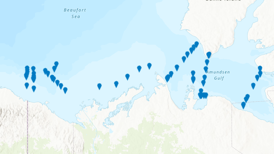
From August 2nd to September 9th, 2013, Fisheries and Oceans Canada conducted a baseline survey of marine fishes and their habitats on the Canadian Beaufort Shelf and slope. Sampling was conducted from the F/V Frosti at 64 stations along ten transects. Standardized sampling was conducted on the transects at pre-determined depth stations (20-40, 75, 200, 350, 500, 750, and 1000 m) using a variety of sampling equipment including benthic fishing trawls, plankton nets, sediment cores, and CTD and water sample profiles. A specialized CTD probe (UCTD) was deployed at an additional 72 locations while the ship was underway.Presented here is the information on the sampling locations, and the sampling gear deployed at each station.
-

From August 5th to September 3rd, 2012, Fisheries and Oceans Canada conducted a baseline survey of marine fishes and their habitats on the Canadian Beaufort Shelf and slope. Sampling was conducted from the F/V Frosti at 28 stations along four transects. Standardized sampling was conducted at pre-determined depth stations (20-40, 75, 200, 350, 500, 750, and 1000 m) using a variety of sampling equipment including benthic fishing trawls, plankton nets, sediment cores, and CTD and water sample profiles. A specialized CTD probe (UCTD) was deployed at an additional 30 locations while the ship was underway. Presented here is the information on the sampling locations, and the sampling gear deployed at each station.