 Arctic SDI catalogue
Regional Assessment
Type of resources
Available actions
Topics
Keywords
Contact for the resource
Provided by
Formats
Representation types
Update frequencies
status
-

Study Area defined in the Agreement to Conduct a Regional Assessment of Offshore Wind Development in Nova Scotia. The study area was created by the Impact Assessment Agency of Canada in collaboration with Natural Resources Canada and the province of Nova Scotia.
-

Study Area defined in the Agreement to Conduct a Regional Assessment of Offshore Wind Development in Newfoundland and Labrador. The study area was created by the Impact Assessment Agency of Canada in collaboration with Natural Resources Canada and the province of Newfoundland and Labrador.
-

Depicts priority area for work under the Regional Assessment of Offshore Wind Development in Newfoundland and Labrador. The Committee for the Regional Assessment of Offshore Wind Development in Newfoundland and Labrador (Committee) is responsible for providing information, knowledge and analysis regarding future offshore wind development (OSW) to inform and improve future planning, licencing and impact assessment processes. The Committee’s mandate is set out in the Agreement to Conduct the Regional Assessment of Offshore Wind Development in Newfoundland and Labrador (Agreement), and includes assessing potential environmental, health, social and economic effects of future OSW. The Agreement includes a broad Study Area. In November 2023, the Committee determined OSW interest in the foreseeable future is more likely within a portion of the Study Area set out in the Agreement. The Committee defined this portion of the Study Area as the assessment's Focus Area. The Committee continues to conduct the Regional Assessment (i.e., present information on existing conditions and consider potential impacts of OSW) within the Focus Area. The Committee's decision to define the Focus Area and supporting rationale is available here: https://iaac-aeic.gc.ca/050/evaluations/document/153431 The Agreement to conduct the Regional Assessment is available here: https://iaac-aeic.gc.ca/050/documents/p84343/147037E.pdf
-

This geospatial data depicts the Draft Offshore Wind Licencing Areas (Draft Areas) recommended by the Committee for the Regional Assessment of Offshore Wind Development in Newfoundland and Labrador (Committee).* Based on work completed to date, the Committee has found the Draft Areas are where offshore wind development would have the least impact within the Regional Assessment Focus Area. Identifying Areas: Section 6 of the Draft Regional Assessment Report (see Data Resources below) includes details on how the Draft Areas were identified. They are the result of the constraints analysis summarized below, with very little modification to area boundaries. The Committee successively removed areas from the Regional Assessment Focus Area (published on Open Government by the Impact Assessment Agency on December 1, 2023). Constraints analysis steps included: • Step 1: Creating Coastal Buffers. • Step 2: Removing Marine Critical Habitat. • Step 3: Removing Marine Protected Areas. • Step 4: Removing Marine Traffic Routes. • Step 5: Removing Areas with High Vessel Traffic. • Step 6: Removing the South Coast Fjords NMCA Study Area. • Step 7: Removing Areas around National Parks & World Heritage Sites. • Step 8: Removing High Density Fishing Areas. • Step 9: Removing Community-based Coastal Resources. An Iterative Process: Identifying offshore wind licencing areas is an iterative process. On March 22, 2024, the Committee submitted its Interim Report to Ministers. This report included a preliminary map of recommended areas for offshore wind development licencing. The preliminary areas were updated based on engagement outcomes, additional data and analysis submitted to the Committee by Regional Assessment participants, and additional research and analysis completed by the Committee between March and October 2024. On October 1, 2024, the Committee’s Draft Report, including updated offshore wind areas, was published for a public comment period. The Draft Areas supersede the Preliminary Offshore Wind Licencing Areas. The Draft Areas are also subject to change. The Committee will submit its Final Report and Initial Offshore Wind Licencing Areas for Consideration to Ministers on or before January 23, 2025. The Committee recommends that regulators consider the forthcoming Initial Offshore Wind Energy Licencing Areas, and the Committee’s report to Ministers, to help inform offshore wind development licencing areas in the region. Latest Update: The Committee’s Final Report and final version of Initial Offshore Wind Energy Licencing Areas for Consideration were submitted to Ministers on January 23, 2025. This completes the Committee’s mandate. Ministers may also choose to make the final versions of these areas available following the Regional Assessment. However, no changes have been made to the geospatial data representing the Draft Areas (published here). Please note the Committee updated the term “Initial Offshore Wind Energy Licencing Areas for Consideration” in the final iteration of their work to better communicate the areas it identified are not licencing areas but are a starting point to help inform the selection of licencing areas. Previous iterations of these areas were called Preliminary Offshore Wind Licencing Areas and Draft Offshore Wind Licencing Areas. *Regional Assessment Background: The federal Ministers of Environment and of Natural Resources, and the provincial Ministers of Industry, Energy and Technology, of Environment and Climate Change, and of Intergovernmental Affairs (Ministers) are signatory to the Regional Assessment Agreement. The goal of the Regional Assessment is to provide information to federal and provincial governments to help them plan for offshore wind development in Newfoundland and Labrador, and complete impact assessments of offshore wind projects. Federal and provincial Ministers appointed an independent committee, comprising five members of diverse backgrounds and expertise to conduct the assessment.
-
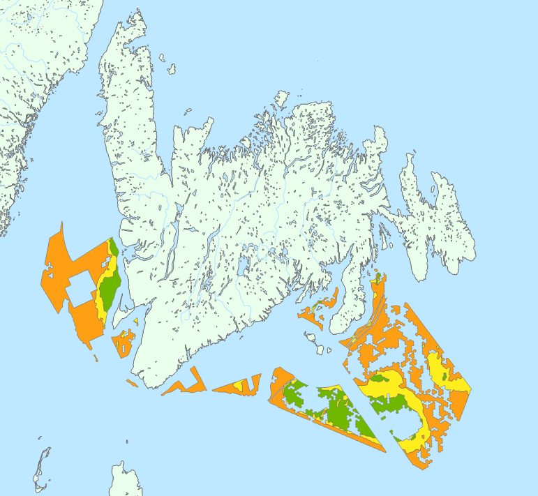
This geospatial data depicts preliminary offshore wind licencing areas recommended by the Committee for the Regional Assessment of Offshore Wind Development in Newfoundland and Labrador (Committee). These areas were identified as an interim product during the Regional Assessment process. The Committee is tasked to complete its Regional Assessment Report by January 2025. As part of the terms of amended agreement set out by the Governments of Canada and Newfoundland and Labrador, the Committee submitted an interim report to Ministers on March 22, 2024. This report included a preliminary map of recommended areas for offshore wind. Based on work completed to date, the Committee has found these areas are where offshore wind development is most likely feasible and will have the least impact within offshore Newfoundland and Labrador. These areas are preliminary and will be refined throughout the remainder of the Regional Assessment. Through the Regional Assessment process, the Committee is providing federal and provincial Ministers with information, knowledge, and analysis regarding future offshore wind development. Their work is intended to inform and improve future planning, licencing, and impact assessment processes. Any offshore wind areas identified by the Committee do not reflect official offshore wind licencing areas. The Committee is providing these areas to Ministers for their consideration, as the offshore wind regulatory process is being established.
-

This geospatial data depicts potential development areas (PDAs) recommended by the Committee for the Regional Assessment of Offshore Wind Development in Nova Scotia. The Committee for the Regional Assessment of Offshore Wind Development in Nova Scotia (Committee) provides federal and provincial Ministers with information, knowledge, and analysis regarding future offshore wind (OSW) development in Nova Scotia. Its work is intended to inform and improve future planning, licencing, permitting, and impact assessment processes. Under the Terms of Reference, the Committee submitted an interim report to Ministers on March 23, 2024. This report included the preliminary identification of recommended areas for potential future development areas (PFDAs) for offshore wind. Based on work completed since the interim report, the Committee issued its final report on January 23, 2025, which included refined development areas, the Potential Development Areas (PDAs). These PDAs are based on technical feasibility (using available information) and have the least impact on other offshore users. It should be noted that the PDAs are recommendations only and do not reflect official offshore wind energy areas.
-

This geospatial data depicts potential future development areas recommended by the Committee for the Regional Assessment of Offshore Wind Development in Nova Scotia. These areas were identified as an interim product during the Regional Assessment process. They do not reflect official offshore wind licencing or development areas. The Committee for the Regional Assessment of Offshore Wind Development in Nova Scotia (Committee) is providing federal and provincial Ministers with information, knowledge, and analysis regarding future offshore wind development (OSW). Their work is intended to inform and improve future planning, licencing, permitting, and impact assessment processes. The Committee is tasked to complete its Regional Assessment Report by January 2025. As part of the terms of the amended agreement set out by the Governments of Canada and Nova Scotia, the Committee submitted an interim report to Ministers on March 22, 2024. This report included the preliminary identification of recommended areas for potential future offshore wind. Based on work completed to date, the Committee has identified areas where offshore wind development is technically feasible (based on available information) and will have the least impact within other offshore users. These areas are preliminary and will be refined throughout the remainder of the Regional Assessment. The offshore wind areas identified by the Committee do not reflect official offshore wind licencing areas. The Committee is providing these areas to Ministers for their consideration, as the offshore wind regulatory process is being established.
-

The assessments layer represents all assessments undertaken under the Impact Assessment Act, including those that continue under the provisions of the Canadian Environmental Assessment Act, 2012. It includes assessments undertaken by the Impact Assessment Agency and other federal authorities as posted on the Canadian Impact Assessment Registry Internet site. The location of a given assessment included in the dataset is approximate and is based on information submitted by proponents, if applicable. More than one location may be identified for a given assessment. This dataset does not include information related to the footprint. Additional information about this dataset is available on the Canadian Impact Assessment Registry Internet site.