 Arctic SDI catalogue
Assessment
Type of resources
Available actions
Topics
Keywords
Contact for the resource
Provided by
Years
Formats
Representation types
Update frequencies
status
Service types
Scale
-
-
-

Unit of Assessment layer**This third party metadata element was translated using an automated translation tool (Amazon Translate).**
-

Units of assessment on the territory of the city of Lévis**This third party metadata element was translated using an automated translation tool (Amazon Translate).**
-

Depicts priority area for work under the Regional Assessment of Offshore Wind Development in Newfoundland and Labrador. The Committee for the Regional Assessment of Offshore Wind Development in Newfoundland and Labrador (Committee) is responsible for providing information, knowledge and analysis regarding future offshore wind development (OSW) to inform and improve future planning, licencing and impact assessment processes. The Committee’s mandate is set out in the Agreement to Conduct the Regional Assessment of Offshore Wind Development in Newfoundland and Labrador (Agreement), and includes assessing potential environmental, health, social and economic effects of future OSW. The Agreement includes a broad Study Area. In November 2023, the Committee determined OSW interest in the foreseeable future is more likely within a portion of the Study Area set out in the Agreement. The Committee defined this portion of the Study Area as the assessment's Focus Area. The Committee continues to conduct the Regional Assessment (i.e., present information on existing conditions and consider potential impacts of OSW) within the Focus Area. The Committee's decision to define the Focus Area and supporting rationale is available here: https://iaac-aeic.gc.ca/050/evaluations/document/153431 The Agreement to conduct the Regional Assessment is available here: https://iaac-aeic.gc.ca/050/documents/p84343/147037E.pdf
-

The property assessment roll presents the inventory of buildings located on the territory of a municipality, assessed on the same basis and at the same date. It is the central element of the Quebec municipal tax system. Here you will find the 1,140 XML files representing all the assessment roles of municipalities in Quebec. It is possible to download the zipped file containing them all or to consult one territory at a time by clicking on the links in the CSV list. Information concerning __cadasters__, __names of owners and their mailing addresses__ are redacted. In order to obtain this information, you can consult a particular unit of assessment on the municipality's website or at the clerk's office. __It is forbidden to re-identify redacted personal information (names and addresses of owners) __.**This third party metadata element was translated using an automated translation tool (Amazon Translate).**
-

Offshore wind represents a potentially significant source of low-carbon energy for Canada, and ensuring that relevant, high-quality data and scientifically sound analyses are brought forward into decision-making processes will increase the chances of success for any future deployment of offshore wind in Canada. To support this objective, CanmetENERGY-Ottawa (CE-O), a federal laboratory within Natural Resources Canada (NRCan), completed a preliminary analysis of relevant considerations for offshore wind, with an initial focus on Atlantic Canada. To conduct the analysis, CE-O used geographic information system (GIS) software and methods and engaged with multiple federal government departments to acquire relevant data and obtain insights from subject matter experts on the appropriate use of these data in the context of the analysis. The purpose of this work is to support the identification of candidate regions within Atlantic Canada that could become designated offshore wind energy areas in the future. The study area for the analysis included the Gulf of St. Lawrence, the western and southern coasts of the island of Newfoundland, and the coastal waters south of Nova Scotia. Twelve input data layers representing various geophysical, ecological, and ocean use considerations were incorporated as part of a multi-criteria analysis (MCA) approach to evaluate the effects of multiple inputs within a consistent framework. Six scenarios were developed which allow for visualization of a range of outcomes according to the influence weighting applied to the different input layers and the suitability scoring applied within each layer. This preliminary assessment resulted in the identification of several areas which could be candidates for future designated offshore wind areas, including the areas of the Gulf of St. Lawrence north of Prince Edward Island and west of the island of Newfoundland, and areas surrounding Sable Island. This study is subject to several limitations, namely missing and incomplete data, lack of emphasis on temporal and cumulative effects, and the inherent subjectivity of the scoring scheme applied. Further work is necessary to address data gaps and take ecosystem wide impacts into account before deployment of offshore wind projects in Canada’s coastal waters. Despite these limitations, this study and the data compiled in its preparation can aid in identifying promising locations for further review. A description of the methodology used to undertake this study is contained in the accompanying report, available at the following link: https://doi.org/10.4095/331855. This report provides in depth detail into how these data layers were compiled and details any analysis that was done on the data to produce the final data layers in this package.
-
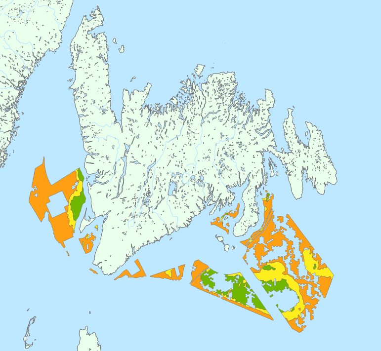
This geospatial data depicts preliminary offshore wind licencing areas recommended by the Committee for the Regional Assessment of Offshore Wind Development in Newfoundland and Labrador (Committee). These areas were identified as an interim product during the Regional Assessment process. The Committee is tasked to complete its Regional Assessment Report by January 2025. As part of the terms of amended agreement set out by the Governments of Canada and Newfoundland and Labrador, the Committee submitted an interim report to Ministers on March 22, 2024. This report included a preliminary map of recommended areas for offshore wind. Based on work completed to date, the Committee has found these areas are where offshore wind development is most likely feasible and will have the least impact within offshore Newfoundland and Labrador. These areas are preliminary and will be refined throughout the remainder of the Regional Assessment. Through the Regional Assessment process, the Committee is providing federal and provincial Ministers with information, knowledge, and analysis regarding future offshore wind development. Their work is intended to inform and improve future planning, licencing, and impact assessment processes. Any offshore wind areas identified by the Committee do not reflect official offshore wind licencing areas. The Committee is providing these areas to Ministers for their consideration, as the offshore wind regulatory process is being established.
-

Spatial distribution of lumpfish catch rates (number per tow) during the August DFO research survey conducted annually since 1990, to assess the state of groundfish and shrimp stocks in the northern Gulf of St. Lawrence. The area sampled by a tow is the product of the distance trawled (fishing time multiplied by vessel speed) and the wing spread (13.41 m for the Alfred Needler and 16.94 m for the Teleost). Given that this area may vary among tows, the sampling unit is standardized and defined as being a station sampled by a tow over a distance of 0.75 nautical miles (1,389 m) with a horizontal wing spread of 16.94 m. Catch variables were calculated based on the standard area, 0.02353 km². After each tow, the catch was sorted by taxa, and the number of individuals and total biomass of these taxa were noted. For taxa identified to the species level, individual biometric parameters (e.g., length, weight) and biological parameters (e.g., sex, maturity of gonads) were recorded based on a subsample. Full methods are described in Bourdages et al. (2010). Note that the increase in catch rate for the 2005-2009 period coincides with a change in gear for this survey. Bourdages, H., and Ouellet, J.-F. 2011. Geographic distribution and abundance indices of marine fish in the northern Gulf of St. Lawrence (1990–2009). Can. Tech. Rep. Fish. Aquat. Sci. 2963: vi + 171 p. Source: Gauthier, J., Grégoire, F., and Nozères, C. 2017. Assessment of Lumpfish (Cyclopterus lumpus) in the Gulf of St. Lawrence (3Pn, 4RS) in 2015. DFO Can. Sci. Advis. Sec. Res. Doc. 2017/051. v + 47 p. Purpose The multidisciplinary survey of groundfish and shrimp in the northern Gulf of St. Lawrence has been conducted every August by Fisheries and Oceans Canada for more than two decades. Initially, its objective was to determine the abundance and geographic distribution of commercially important taxa. However, for couple of years, the objective was expanded to include all taxa caught with the shift toward the ecosystem approach.
-

This geospatial data depicts potential development areas (PDAs) recommended by the Committee for the Regional Assessment of Offshore Wind Development in Nova Scotia. The Committee for the Regional Assessment of Offshore Wind Development in Nova Scotia (Committee) provides federal and provincial Ministers with information, knowledge, and analysis regarding future offshore wind (OSW) development in Nova Scotia. Its work is intended to inform and improve future planning, licencing, permitting, and impact assessment processes. Under the Terms of Reference, the Committee submitted an interim report to Ministers on March 23, 2024. This report included the preliminary identification of recommended areas for potential future development areas (PFDAs) for offshore wind. Based on work completed since the interim report, the Committee issued its final report on January 23, 2025, which included refined development areas, the Potential Development Areas (PDAs). These PDAs are based on technical feasibility (using available information) and have the least impact on other offshore users. It should be noted that the PDAs are recommendations only and do not reflect official offshore wind energy areas.