 Arctic SDI catalogue
bioclimate, ecoclimatic regions, vegetation, biome, zone
Type of resources
Available actions
Topics
Keywords
Contact for the resource
Provided by
Formats
Representation types
Update frequencies
status
-
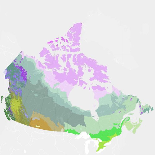
"Vegetation Zones of Canada: a Biogeoclimatic Perspective" maps Canadian geography in relation to gradients of regional climate, as expressed by potential vegetation on zonal sites. Compared to previous similar national-scale products, "Vegetation Zones of Canada" benefits from the work of provincial and territorial ecological classification programs over the last 30+ years, incorporating this regional knowledge of ecologically significant climatic gradients into a harmonized national map. This new map, reflecting vegetation and soils adapted to climates prior to approximately 1960, can serve as a broad-scale (approximately 1:5 M to 1:10 M) geospatial reference for monitoring and modeling effects of climate changes on Canadian ecosystems. "Vegetation Zones of Canada: a Biogeoclimatic Perspective" employs a two-level hierarchical legend. Level 1 vegetation zones reflect the global-scale latitudinal gradient of annual net radiation, as well as the effects of high elevation and west to east climatic and biogeographic variation across Canada. Within the level 1 vegetation zones, level 2 zones distinguish finer scale variation in zonal vegetation, especially in response to elevational and arctic climatic gradients, climate-related floristics and physiognomic diversity in the Great Plains, and maritime climatic influences on the east and west coasts. Thirty-three level 2 vegetation zones are recognized: High Arctic Sparse Tundra Mid-Arctic Dwarf Shrub Tundra Low Arctic Shrub Tundra Subarctic Alpine Tundra Western Boreal Alpine Tundra Cordilleran Alpine Tundra Pacific Alpine Tundra Eastern Alpine Tundra Subarctic Woodland-Tundra Northern Boreal Woodland Northwestern Boreal Forest West-Central Boreal Forest Eastern Boreal Forest Atlantic Maritime Heathland Pacific Maritime Rainforest Pacific Dry Forest Pacific Montane Forest Cordilleran Subboreal Forest Cordilleran Montane Forest Cordilleran Rainforest Cordilleran Dry Forest Eastern Temperate Mixed Forest Eastern Temperate Deciduous Forest Acadian Temperate Forest Rocky Mountains Foothills Parkland Great Plains Parkland Intermontane Shrub-Steppe Rocky Mountains Foothills Fescue Grassland Great Plains Fescue Grassland Great Plains Mixedgrass Grassland Central Tallgrass Grassland Cypress Hills Glaciers Please cite this dataset as: Baldwin, K.; Allen, L.; Basquill, S.; Chapman, K.; Downing, D.; Flynn, N.; MacKenzie, W.; Major, M.; Meades, W.; Meidinger, D.; Morneau, C.; Saucier, J-P.; Thorpe, J.; Uhlig, P. 2019. Vegetation Zones of Canada: a Biogeoclimatic Perspective. [Map] Scale 1:5,000,000. Natural Resources Canada, Canadian Forest Service. Great Lake Forestry Center, Sault Ste. Marie, ON, Canada.