 Arctic SDI catalogue
Ecology
Type of resources
Available actions
Topics
Keywords
Contact for the resource
Provided by
Years
Formats
Representation types
Update frequencies
status
Service types
-

The National Ecological Framework for Canada's "Elevation by Ecoregion” dataset provides elevation information for ecoregion framework polygons, in meters. It includes codes and descriptions for minimum elevation, maximum elevation, mean elevation and the difference in elevation.
-

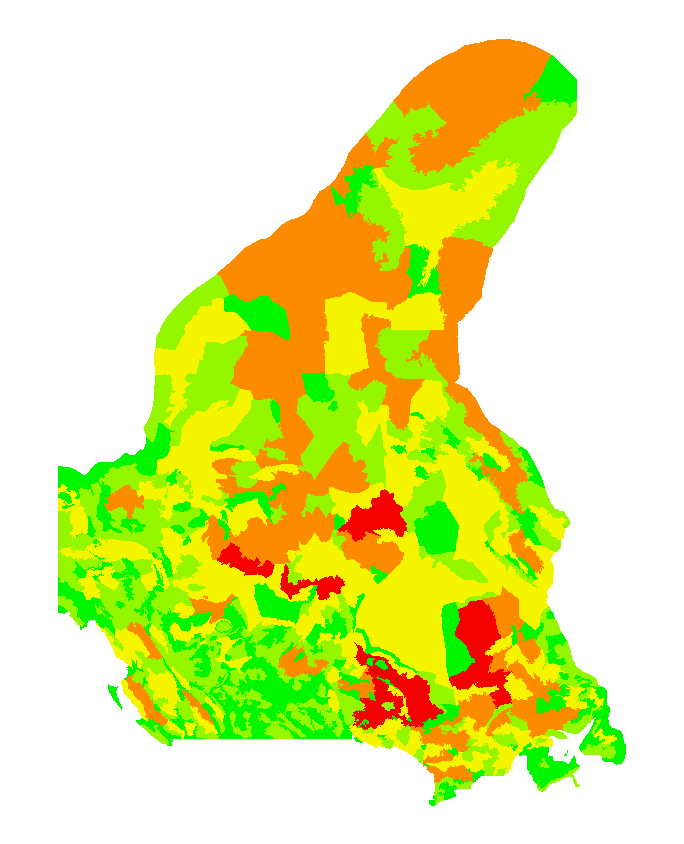
The “Agro-Pedological Atlas of Quebec” is a dataset that shows the characteristics, the fertility, the quality of the water regime, the vulnerability to degradation and the potential of the agricultural soils and land in the Monteregian region of the province of Quebec.
-
The National Ecological Framework for Canada (v2.2) provides a consistent, national spatial framework that allows various ecosystems to be described, monitored and reported on. It provides standard ecological units that allow different jurisdictions and disciplines to use common communication and reporting, and a common ground to report on the state of the environment and the sustainability of ecosystems in Canada. The framework was developed between 1991 and 1999 by the Ecosystems Science Directorate, Environment Canada and the Center for Land and Biological Resources Research, Agriculture and Agri-Food Canada. Over 100 federal and provincial agencies, non-governmental organizations and private sector companies contributed to its development. For more information, visit: www.agr.gc.ca/atlas/metadata/3ef8e8a9-8d05-4fea-a8bf-7f5023d2b6e1
-

The National Ecological Framework for Canada's "Land Cover by Ecoregion” dataset provides land cover information within the ecoregion framework polygon. It provides landcover codes and their English and French language description as well as information about the percentage of the polygon that the component occupies.
-

Between 2001 and 2004 a descriptive and comparative investigation of the benthic macro-infauna in 17 pockmarks and 10 reference locations outside pockmarks in Passamaquoddy Bay-Bay of Fundy- was made. This dataset contains the locations of the grab samples for each pockmark in the study area, the taxon abundance identified in each sample and the georeferenced video transect from 2004 using a towcam- an underwater, bottom referencing vehicle on which floodlights, analogue video- and digital still-camera were mounted. For more information of the data: Wildish DJ, Akagi HM, McKeown DL, Pohle GW (2008) Pockmarks influence benthic communities in Passamaquoddy Bay, Bay of Fundy, Canada. Mar Ecol Prog Ser 357:51-66. https://www.int-res.com/abstracts/meps/v357/p51-66/
-

The National Ecological Framework for Canada's "Landform by Ecozone” series contains tables that provide regional landform information for components within the ecozone framework polygon. It provides landform codes and their English and French-language descriptions as well as information about the percentage of the polygon that the component occupies. Regional landforms generally describe a region and include the various shapes of the land surface resulting from a variety of actions such as deposition or sedimentation (eskers, lacustrine basins), erosion (gullies, canyons), and earth crust movements (mountains). The regional landform classes are: plateau or tableland, hill and mountain, organic wetland, plain, scarp or valley.
-
The National Ecological Framework for Canada's "Land and Water Area by Province/Territory and Ecodistrict” dataset provides land and water area values by province or territory for the Ecodistrict framework polygon, in hectares. It includes codes and their English and French descriptions for a polygon’s province or territory, total area, land-only area and large water body area.
-

The National Ecological Framework for Canada's "Surface Form by Ecoregion" dataset contains tables that provide surface form information for components within the ecoregion framework polygon. It provides surface form codes and their English and French-language descriptions as well as information about the percentage of the polygon that the component occupies. Surface form descriptions describe assemblages of slopes or recurring patterns of forms that occur at the earth's surface. When applied to consolidated materials (material that has been transformed to hard rock), it refers to the form produced after modification by geological processes. The mineral soil surface forms are: dissected; hummocky (irregular); inclined; level, rolling; ridged; steep; terraced; undulating. The wetland surface forms are: bog; fen; marsh; swamp.
-
The National Ecological Framework for Canada provides a consistent, national spatial framework that allows various ecosystems to be described, monitored and reported on. It provides standard ecological units that allow different jurisdictions and disciplines to use common communication and reporting, and a common ground to report on the state of the environment and the sustainability of ecosystems in Canada. The framework was developed between 1991 and 1999 by the Ecosystems Science Directorate, Environment Canada and the Center for Land and Biological Resources Research, Agriculture and Agri-Food Canada. Over 100 federal and provincial agencies, non-governmental organizations and private sector companies contributed to its development.
-

The National Ecological Framework for Canada's "Landform by Ecoprovince” series contains tables that provide regional landform information for components within the ecoprovince framework polygon. It provides landform codes and their English and French-language descriptions as well as information about the percentage of the polygon that the component occupies. Regional landforms generally describe a region and include the various shapes of the land surface resulting from a variety of actions such as deposition or sedimentation (eskers, lacustrine basins), erosion (gullies, canyons), and earth crust movements (mountains). The regional landform classes are: plateau or tableland, hill and mountain, organic wetland, plain, scarp or valley.