 Arctic SDI catalogue
permafrost
Type of resources
Available actions
Topics
Keywords
Contact for the resource
Provided by
Formats
Representation types
Update frequencies
status
-
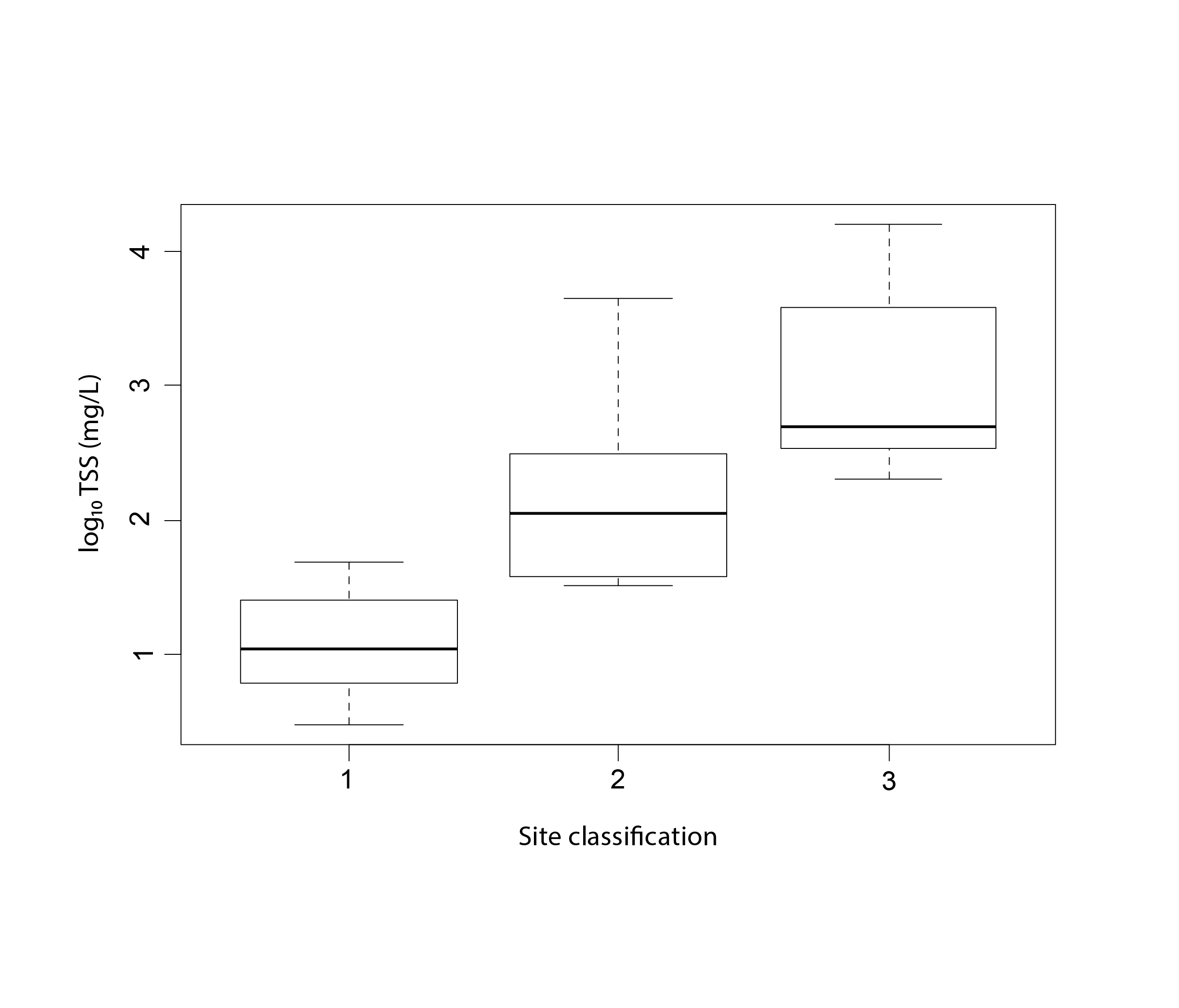
Figure 3-4 Effects of permafrost thaw slumping on Arctic rivers, including (upper) a photo of thaw slump outflow entering a stream on the Peel Plateau, Northwest Territories, Canada, and (lower) log10-transformed total suspended solids (TSS) in (1) undisturbed, (2) 1-2 disturbance, and (3) > 2 disturbance stream sites, with letters indicating significant differences in mean TSS among disturbance classifications Plot reproduced from Chin et al. (2016). State of the Arctic Freshwater Biodiversity Report - Chapter3 - Page 21 - Figure 3-4
-
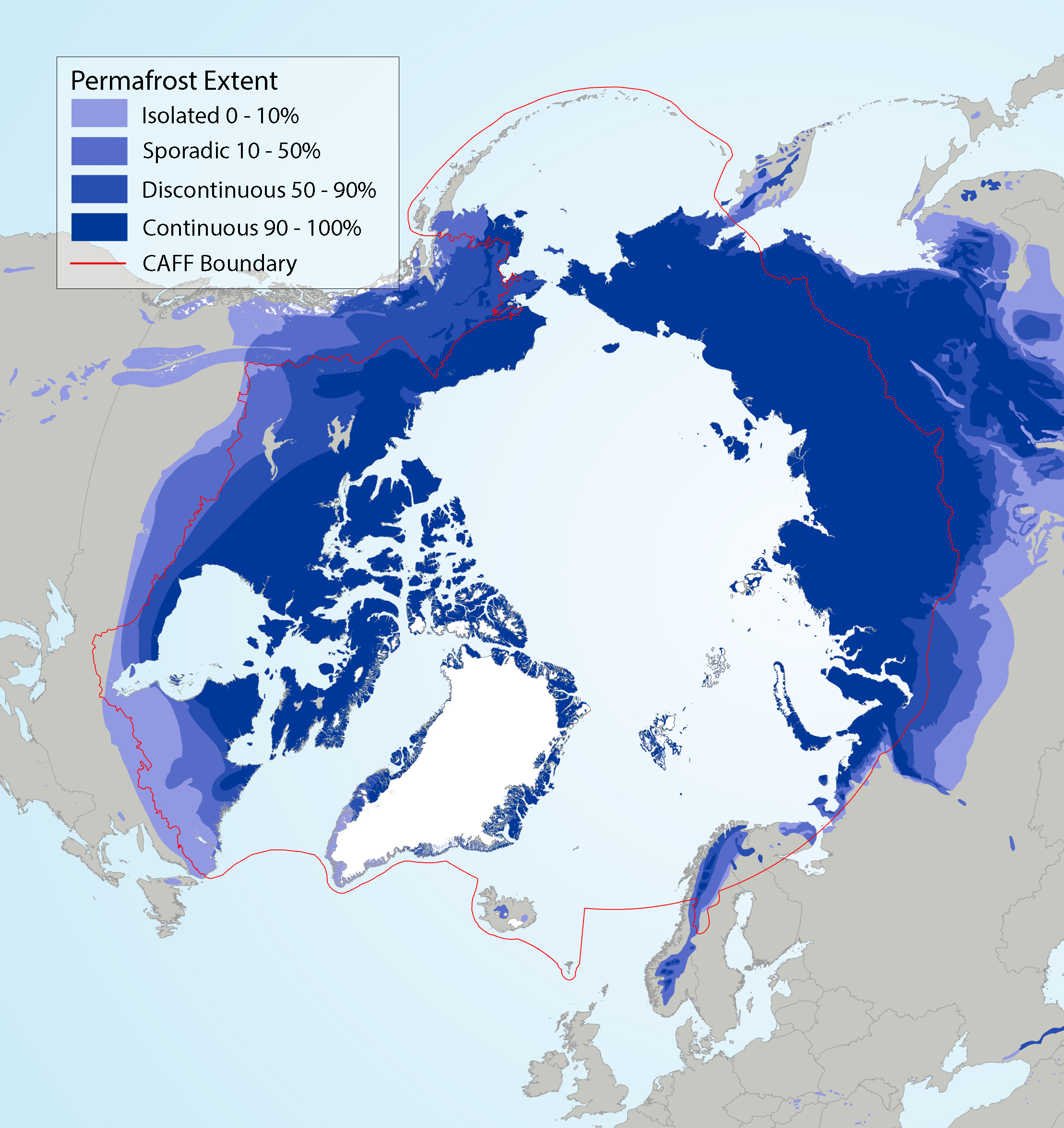
Circumpolar permafrost extent overlain on ecoregions used in SAFBR analysis, indicating continuous (90-100%), discontinuous (50-90%), sporadic (10-50%), and isolated (0-10%) permafrost extent. Source for permafrost layer: Brown et al. (2002). State of the Arctic Freshwater Biodiversity Report - Chapter 5 - Page 89 - Figure 5-6
-
Surficial Geology of the Central Kluane Ranges (parts of NTS 115B/15, 16 and 115G /1, 2, 3, 6 and 7)

Surficial geological mapping in the central Kluane Ranges was undertaken to better understand the distribution and character of surficial materials. Upland surficial materials in the area are dominated by near-source bedrock derivatives. Valley bottom settings, including Shakwak trench and Duke River valley, are characterized by broad open valleys with thick deposits of Quaternary sediment. Permafrost is discontinuous in the study area and its character is affected by slope and aspect, topography and material texture. Mass wasting processes in the study area include rockfall and avalanches, debris flows, debris avalanches and active layer detachment slides. The distribution and character of surficial materials are significant for soil geochemical sampling programs, mineral exploration, infrastructure and development.
-
Detailed surficial geology mapping (1:15 000 scale) was carried out from 2022-2024 for the area surrounding the Village of Haines Junction in southwestern Yukon, within the Traditional Territory of the Champagne and Aishihik First Nations. Mapping was based on desktop interpretations of high-resolution lidar, as well as air photo and satellite imagery. This was further supported by a variety of field investigations including analysis of stratigraphic sections and geotechnical drill logs. The map portrays properties of surface sediments, including texture, genetic material, surface expression and stratigraphy. Geomorphological processes that presently modify surficial materials and/or did so in the past, are also identified. Some of these processes include geohazards such as landslides, permafrost thaw and flooding. A variety of landforms which indicate the presence of permafrost are mapped, including pingos, thermokarst collapse ponds, lithalsas and retrogressive thaw flow landslides. Locations of recent permafrost investigations are also shown, including geophysical surveys and shallow boreholes drilled to establish permafrost-monitoring stations. This work will ultimately support a variety of community activities, such as land use planning, archeological investigations, agricultural development, aggregate exploration, and infrastructure work. It also helps to better constrain the unique history of Neoglacial Lake Alsek, which inundated the area multiple times during recent advances of the Lowell Glacier across the Alsek River.
-

In July and August of 2019, a remotely piloted aircraft system (RPAS) project was undertaken in Canada’s western Arctic along the Inuvik to Tuktoyaktuk (ITH) and Dempster highways. The objective of this project was to test long-range RPAS missions for photogrammetric data acquisition and processing of these two Arctic highway corridors with embankments, bridges and culverts at risk of changing environmental and climatic regimes. The imagery was used to derive an orthomosaic and digital elevation model that could be used to measure road infrastructure and landscape change over time (e.g., fish habitat). The RPAS missions were conducted with a Griffon SeaHunter and full-frame DSLR sensor and scoped to obtain <10 cm spatial resolution imagery along a combined 396 linear km. The final deliverables covered over 22,000 ha and 29,000 ha for the ITH and Dempster Highways, respectively, and represent one of the first non-military beyond-visual-line-of-sight RPAS data products of its kind and scale in Canada, and likely elsewhere. At the time of collection the data constituted the most current and detailed photo surveys of two of Canada’s most northern highways constructed over ice-rich permafrost terrain, and will provide a valuable baseline to study past and future landscape change.
-
The Yukon Geological Survey has compiled a collection of papers, theses, reports and maps that describe permafrost in the Yukon. These reports have been footprinted and indexed to make them easier to find spatially. Distributed from [GeoYukon](https://yukon.ca/geoyukon) by the [Government of Yukon](https://yukon.ca/maps) . Discover more digital map data and interactive maps from Yukon's digital map data collection. For more information: [geomatics.help@yukon.ca ](mailto:geomatics.help@yukon.ca)
-
Oil and gas well reports to be used in conjunction with Oil and Gas Wells - 50k. Distributed from [GeoYukon](https://yukon.ca/geoyukon) by the [Government of Yukon](https://yukon.ca/maps) . Discover more digital map data and interactive maps from Yukon's digital map data collection. For more information: [geomatics.help@yukon.ca](mailto:geomatics.help@yukon.ca)
-
Geotechnical data comes from investigations performed by geotechnical engineers to obtain information on the physical properties of soil and rock underlying a site for proposed structures. The investigations include surface exploration and subsurface exploration of a site. In addition, site investigations will often include subsurface sampling and laboratory testing of the soil samples retrieved. The digging of test pits and trenching may also be used to learn about soil conditions at depth. Geotechnical data is relevant to our permafrost database as it contains logs of ice encountered at various depths. Yukon Geological Survey has been compiling geotechnical data from various organizations and branches. The main datasets being compiled are the following: Northern Climate Exchange Community Services, Land Branch Energy Mines and Resources, Abandoned Mines Transportation Engineering Branch Alaska Highway Borehole Database Agriculture soil profiles Distributed from [GeoYukon](https://yukon.ca/geoyukon) by the [Government of Yukon](https://yukon.ca/maps) . Discover more digital map data and interactive maps from Yukon's digital map data collection. For more information: [geomatics.help@yukon.ca](mailto:geomatics.help@yukon.ca)
-
Landscape hazard maps were completed as part of a community hazards mapping program coordinated by the Northern Climate ExChange (Yukon Research Centre, Yukon College). Potential landscape hazards were assessed under changing future conditions by incorporating a variety of data sets, including surficial geology, topography (slope and aspect), permafrost distribution, site-specific permafrost data (e.g. ground penetrating radar, electrical resistivity tomography and borehole data), analyses of past hydrological and climatological trends, and future climate projections. The landscape hazard map identifies existing and potential geological hazards such as landslides, permafrost stability and flooding. The hazard map is presented in stoplight colours to provide an intuitive tool for community decision makers aiming to incorporate an adaptation planning framework into existing land use management practices. Detailed descriptions of data inputs and hazard analysis methodology are presented in an accompanying report (available for download from [https://data.geology.gov.yk.ca/Reference/68408](https://data.geology.gov.yk.ca/Reference/68408) ). An accompanying surficial geological map also describes detailed landscape characteristics such as surface landscape features, sediment texture, genetic material, surface expression and geomorphological processes (available for download from [https://data.geology.gov.yk.ca/Reference/68408](https://data.geology.gov.yk.ca/Reference/68408) ). Distributed from [GeoYukon](https://yukon.ca/geoyukon) by the [Government of Yukon](https://yukon.ca/maps) . Discover more digital map data and interactive maps from Yukon's digital map data collection. For more information: [geomatics.help@yukon.ca](mailto:geomatics.help@yukon.ca)
-
The Yukon Geological Survey has compiled a collection of papers, theses, reports and maps that describe permafrost in the Yukon. These reports have been footprinted and indexed to make them easier to find spatially. Distributed from [GeoYukon](https://yukon.ca/geoyukon) by the [Government of Yukon](https://yukon.ca/maps) . Discover more digital map data and interactive maps from Yukon's digital map data collection. For more information: [geomatics.help@yukon.ca ](mailto:geomatics.help@yukon.ca)