 Arctic SDI catalogue
0
Type of resources
Available actions
Topics
Keywords
Contact for the resource
Provided by
Years
Formats
Scale
-
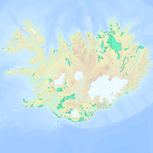
Gagnasett sem sýnir yfirlitsupplýsingar um helstu svæði þar sem landgræðsla er stunduð og Land og skógur kemur að á einn eða annan hátt. Undanskilin eru þó svæði í verkefninu Bændur græða landið.
-
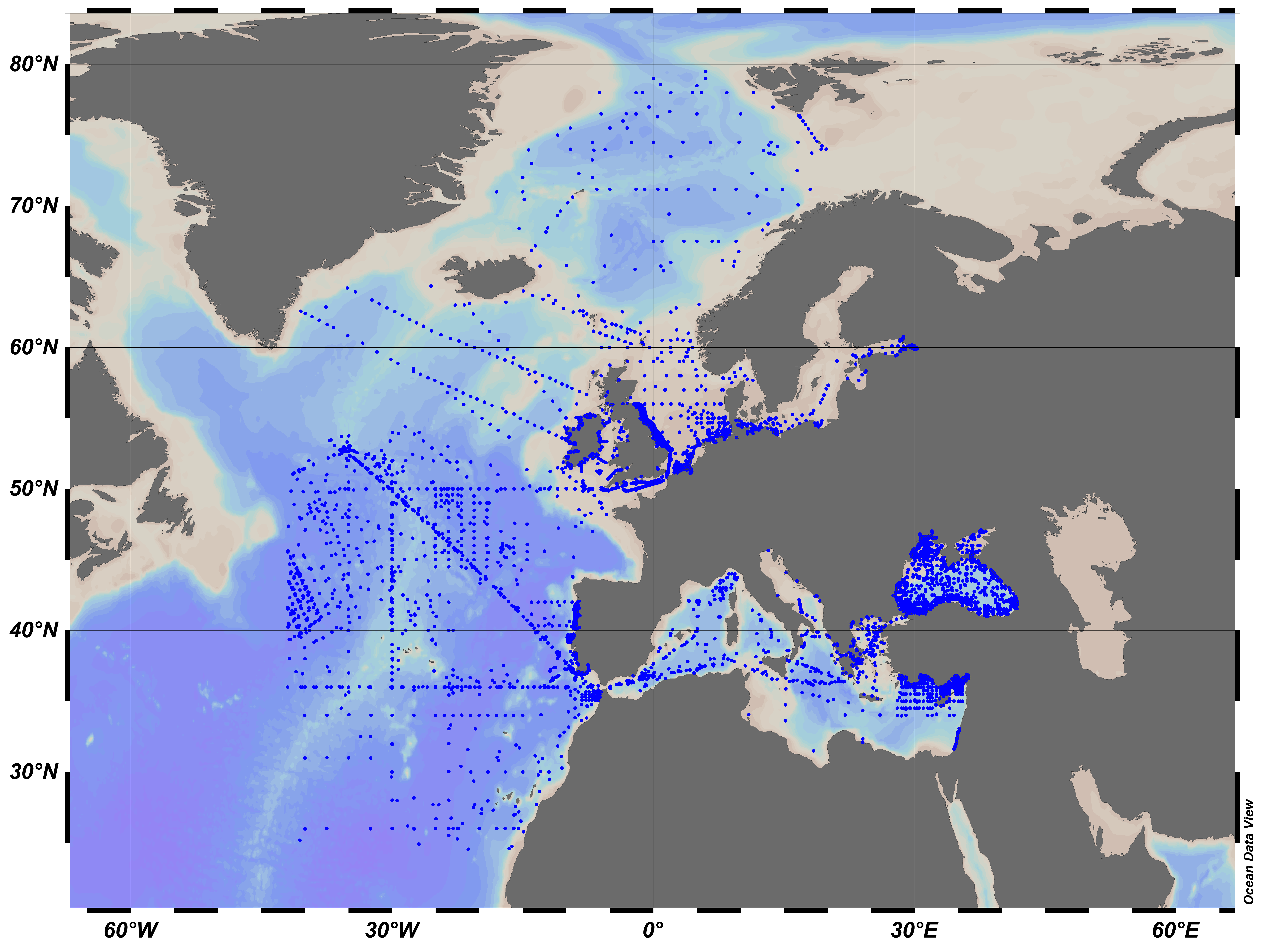
EMODnet Chemistry aims to provide access to marine chemistry datasets and derived data products concerning eutrophication, acidity and contaminants. The importance of the selected substances and other parameters relates to the Marine Strategy Framework Directive (MSFD). This European aggregated dataset contains all unrestricted EMODnet Chemistry data on potential hazardous substances, despite the fact that some data might not be related to pollution (e.g. collected by deep corer). Temperature, salinity and additional parameters are included when available. It covers the Artic Ocean, the North East Atlantic, the Greater North Sea and Celtic Seas, the Baltic Sea, the Mediterranean Sea and the Black Sea. It is produced by the merging of the regional data sets for the above mentioned six regions. Regional datasets were harmonised and validated regionally by: 'Institute of Marine Research - Norwegian Marine Data Centre (NMD)' (Norway), 'IFREMER / IDM / SISMER - Scientific Information Systems for the SEA' (France), 'Aarhus University, Department of Bioscience, Marine Ecology Roskilde' (Denmark), 'Swedish Meteorological and Hydrological Institute (SMHI)' (Sweden), 'Hellenic Centre for Marine Research, Hellenic National Oceanographic Data Centre (HCMR/HNODC)' (Greece) and 'National Institute for Marine Research and Development 'Grigore Antipa' (Romania). Regional datasets concerning contaminants are automatically harvested and the resulting collections are harmonised and validated using ODV Software and following a common methodology for all sea regions ( https://doi.org/10.6092/8b52e8d7-dc92-4305-9337-7634a5cae3f4). Parameter names are based on P01 vocabulary, which relates to BODC Parameter Usage Vocabulary and is available at: https://vocab.nerc.ac.uk/search_nvs/P01/. The European aggregated and harmonized contaminant dataset contains water, sediment and biota profiles and timeseries. The temporal coverage is 1970–2024 for water measurements, 1966–2023 for sediment measurements and 1972–2022 for biota measurements. The European aggregated and harmonized contaminant dataset can be downloaded as an ODV spreadsheet, which is composed of a metadata header followed by tab separated values. This spreadsheet can be imported into ODV Software for visualization (more information can be found at: https://www.seadatanet.org/Software/ODV). In addition, the same dataset is offered also as a txt file in a long/vertical format, in which each P01 measurement is a record line. Additionally, there are a series of columns that split P01 terms into subcomponents (substance, CAS number, matrix...). This transposed format is more adapted to worksheet applications (e.g. LibreOffice Calc).
-
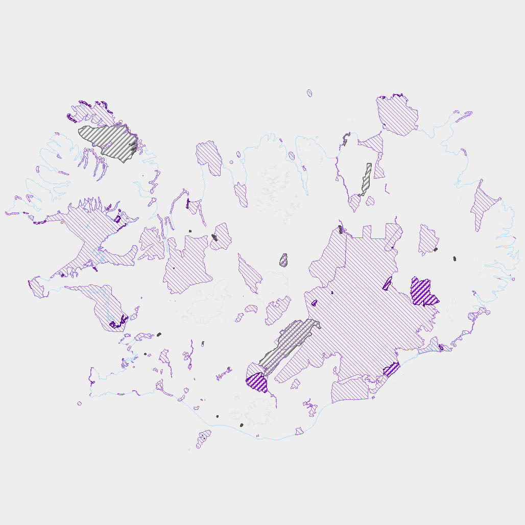
Þekja ni_tillogur_a_Bhluta_allt_fl: Tillögur að svæðum á framkvæmdaáætlun (B-hluta) náttúruminjaskrár út frá verndun vistgerða, fugla, sela, jarðminja og fossa. Innan stærri verndarsvæða voru í sumum tilfellum afmörkuð smærri svæði sem draga fram forgangsvistgerðir eða fuglategundir sem eru ekki einkennandi fyrir heildarsvæðið. Mörk eru ekki alltaf nákvæmlega skilgreind. Náttúruminjaskrá skiptist í þrjá hluta sem auðkenndir eru sem A, B og C-hluti. B-hluti er framkvæmdaáætlun náttúruminjaskrár þ.e. skrá yfir þær náttúruminjar sem Alþingi hefur ákveðið að setja í forgang um friðlýsingu eða friðun á næstu fimm árum. Í lögunum er lögð áhersla á að byggja upp skipulegt net verndarsvæða til að stuðla að vernd líffræðilegrar fjölbreytni, jarðbreytileika og fjölbreytni landslags. Náttúrufræðistofnun Íslands gerir tillögur um minjar sem ástæða þykir til að setja á framkvæmdaáætlun, þ.e. B-hluta. Að loknu því vali felur ráðherra Umhverfisstofnun að meta nauðsynlegar verndarráðstafanir á svæðum sem til greina kemur að setja á framkvæmdaáætlun og kostnað við þær. Í því ferli koma fram ýmsir aðrir hagsmunir sem geta haft áhrif á endanlegt val svæða en eru sem slíkir ekki grunnþættir í vali á svæðum til að viðhalda ákjósanlegri verndarstöðu vistgerða, vistkerfa eða tegunda. Að lokum mun Umhverfis-, orku- og loftslagsráðuneytið í samráði við ráðgjafanefnd leggja fram þingsályktunartillögu um verndun svæða. Tillögurnar eru enn í úrvinnslu hjá Umhverfisstofnun og umhverfis-, orku- og loftslagsráðherra (staða 23. febrúar 2022). Afmörkun svæða í tillögum Náttúrufræðistofnunar er ekki alltaf nákvæmlega skilgreind og getur tekið breytingum við áframhaldandi undirbúning framkvæmdaáætlunar.
-
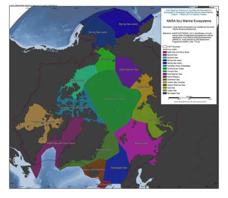
The Arctic Council’s 2009 Arctic Marine Shipping Assessment (AMSA) identified a number of recommendations to guide future action by the Arctic Council, Arctic States and others on current and future Arctic marine activity. Recommendation II C under the theme Protecting Arctic People and the Environment recommended: “That the Arctic states should identify areas of heightened ecological and cultural significance in light of changing climate conditions and increasing multiple marine use and, where appropriate, should encourage implementation of measures to protect these areas from the impacts of Arctic marine shipping, in coordination with all stakeholders and consistent with international law.” As a follow-up to the AMSA, the Arctic Council’s Arctic Monitoring and Assessment Programme (AMAP) and Conservation of Arctic Flora and Fauna (CAFF) working groups undertook to identify areas of heightened ecological significance, and the Sustainable Development Working Group (SDWG) undertook to identify areas of heightened cultural significance. The work to identify areas of heightened ecological significance builds on work conducted during the preparation of the AMAP (2007) Arctic Oil and Gas Assessment. Although it was initially intended that the identification of areas of heightened ecological and cultural significance would be addressed in a similar fashion, this proved difficult. The information available on areas of heightened cultural significance was inconsistent across the Arctic and contained gaps in data quality and coverage which could not be addressed within the framework of this assessment. The areas of heightened cultural significance are therefore addressed within a separate section of the report (Part B) and are not integrated with the information on areas of heightened ecological significance (Part A). In addition, Part B should be seen as instructive in that it illustrates where additional data collection and integration efforts are required, and therefore helps inform future efforts on identification of areas of heightened cultural significance. The results of this work provide the scientific basis for consideration of protective measures by Arctic states in accordance with AMSA recommendation IIc, including the need for specially designated Arctic marine areas as follow-up to AMSA recommendation IId. Reference: AMAP/CAFF/SDWG, 2013. Identification of Arctic marine areas of heightened ecological and cultural significance: Arctic Marine Shipping Assessment (AMSA) IIc. Arctic Monitoring and Assessment Programme (AMAP), Oslo. 114 pp. Data avaiable from: source: <a href="http://www.amap.no/documents/doc/Identification-of-Arctic-marine-areas-of-heightened-ecological-and-cultural-significance-Arctic-Marine-Shipping-Assessment-AMSA-IIc/869" target="_blank">Identification of Arctic marine areas of heightened ecological and cultural significance</a>
-
EMODnet Chemistry aims to provide access to marine chemistry datasets and derived data products concerning eutrophication, acidity and contaminants. The importance of the selected substances and other parameters relates to the Marine Strategy Framework Directive (MSFD). This European aggregated dataset contains all unrestricted EMODnet Chemistry data on potential hazardous substances, despite the fact that some data might not be related to pollution (e.g. collected by deep corer). Temperature, salinity and additional parameters are included when available. It covers the Artic Ocean, the North East Atlantic, the Greater North Sea and Celtic Seas, the Baltic Sea, the Mediterranean Sea and the Black Sea. It is produced by the merging of the regional data sets for the above mentioned six regions. Regional datasets were harmonised and validated regionally by: 'Institute of Marine Research - Norwegian Marine Data Centre (NMD)' (Norway), 'IFREMER / IDM / SISMER - Scientific Information Systems for the SEA' (France), 'Aarhus University, Department of Bioscience, Marine Ecology Roskilde' (Denmark), 'Swedish Meteorological and Hydrological Institute (SMHI)' (Sweden), 'Hellenic Centre for Marine Research, Hellenic National Oceanographic Data Centre (HCMR/HNODC)' (Greece) and 'National Institute for Marine Research and Development 'Grigore Antipa' (Romania). Regional datasets concerning contaminants are automatically harvested and the resulting collections are harmonised and validated using ODV Software and following a common methodology for all sea regions ( https://doi.org/10.6092/8b52e8d7-dc92-4305-9337-7634a5cae3f4). Parameter names are based on P01 vocabulary, which relates to BODC Parameter Usage Vocabulary and is available at: https://vocab.nerc.ac.uk/search_nvs/P01/. The European aggregated and harmonized contaminant dataset contains water, sediment and biota profiles and timeseries. The temporal coverage is 1974–2021 for water measurements, 1966–2022 for sediment measurements and 1979–2021 for biota measurements. The European aggregated and harmonized contaminant dataset can be downloaded as an ODV spreadsheet, which is composed of a metadata header followed by tab separated values. This spreadsheet can be imported into ODV Software for visualization (more information can be found at: https://www.seadatanet.org/Software/ODV). In addition, the same dataset is offered also as a txt file in a long/vertical format, in which each P01 measurement is a record line. Additionally, there are a series of columns that split P01 terms into subcomponents (substance, CAS number, matrix...). This transposed format is more adapted to worksheet applications (e.g. LibreOffice Calc).
-
Vinsamlega hafið samband við Hafrannsóknastofnun vegna nánanri upplýsinga.
-
Í grunninum eru upplýsingar um botnþörunga sem safnað hefur verið í fjörum og á grunnsævi við Ísland. Upplýsingar eru um tegund, fundarstað, söfnunartíma, nafn safnara og nafn þess sem greindi tegundina. Í sumum tilfellum er einnig skráðar upplýsingar um æxlunareinkenni eintaksins og aðrar upplýsingar um eintakið sem þykja áhugaverðar. Botnþörungar eru þörungar sem vaxa í fjörum og landgrunni, þeir festa sig við botn, steinar eða aðrir þörunga og finnast yfirleitt á 20m til 40m dýpi en neðar en það er ekki nægt sólarljós til að þörungar geta vaxið. Botnþörugnar skiptist í þrjá meginhópa, grænþörungar, brúnþörungar og rauðþörugnar og ræðst nafnið á ráðandi lit í hverjum hóp fyrir sig. Grænþörungar hafa dreift meira í ferskvatni og á landi en brún- og rauðþörungar lifa eingöngu í sjó. Fyrir utan kalkþörungar eru þörungar yfirleitt mjúkir og sveigjanlegir, sumir þörungar hafa þykkar blöðrur en aðrir eru aðeins örþunn himna, örfínir þræðir eða skorpur á steinum og dýrum.
-

Vinsamlega hafið samband við Hafrannsóknastofnun vegna nánanri upplýsinga.
-

Vinsamlega hafið samband við Hafrannsóknastofnun vegna nánari upplýsinga.
-

Líffræðiupplýsingar um fiska og önnur sjávardýr, úr leiðöngrum og sýnatöku úr afla. Í fiskagrunni stofnunarinnar eru upplýsingar um rannsóknir frá byrjun síðustu aldar til dagsins í dag, þannig eru elstu gögnin frá árinu 1902. Rannsóknir byggja oftast á leiðöngrum sem farnir eru ýmist með skipum stofnunarinnar eða leiguskipum.