 Arctic SDI catalogue
Écosystème aquatique
Type of resources
Categories
Available actions
Keywords
Contact for the resource
Provided by
Years
Formats
Representation types
Update frequencies
status
Service types
-

This dataset was designed for Environment and Climate Change Canada's (ECCC) National Environmental Emergencies Center (NEEC) for oil spill preparedness and response. The polygons from this layer come mainly from the coastal ecosystems geodatabase as part of the Mapping of coastal ecosystems of the Estuary and Gulf of St. Lawrence project. This layer represents semi-vegetated and vegetated zones of which eelgrass is the dominant vegetation. The study area includes all of the estuarine and maritime coasts of Quebec, with the exception of certain sectors, including most of the Lower North Shore and Anticosti Island, with the exception of villages of Kegaska, la Romaine, Chevery, Blanc-Sablon and Port-Menier. Some islands off the estuary and gulf coasts are part of the region covered, such as Île d'Orléans, Isle-aux-Coudres, Île Verte and Île Bonaventure. The Mapping of coastal ecosystems of the Estuary and Gulf of St. Lawrence was carried out jointly by the Laboratory for Dynamics and Integrated Coastal Zone Management (LDGIZC) of the University of Quebec at Rimouski as part of the Coastal Resilience Project (https: //ldgizc.uqar.ca/Web/projets/projet-resilience-cotiere) funded by the MELCC; and by the Fisheries and Oceans Canada team, as part of its Integrated marine response planning (IMRP) component of the Oceans Protection Plan (OPP), with the objective of updating the Marine Oil Spill Preparedness and Response Regime of Canada. The master geodatabase of coastal ecosystems is hosted and distributed by UQAR on their SIGEC-Web mapping platform: https://ldgizc.uqar.ca/Web/sigecweb The characterization of eelgrass beds was mainly carried out using photo-interpretation of RVBI aerial photos acquired by DFO (2015-2020) and oblique photos taken by helicopter by UQAR in 2017. This dataset also includes the information from validation stations visited by UQAR (2018-2020). Data from sampling stations, carried out aboard small boats during DFO field campaigns (2017-2021), were also used to validate and refine the photo-interpretation. This dataset also includes eelgrass beds characterized in the Basse-Côte-Nord (MRC Le Golfe-de-Saint-Laurent) by the Agence Mamu Innu Kaikusseht (AMIK) as part of the project ''Involvement of Innu communities in the protection of species at risk and their habitats 2010-2011''. These data were produced during aerial overflights at low altitude (200m and 400m) of the foreshore, as 2 observers circumscribed and documented the covering of eelgrass beds. Credits © UQAR-MPO-AMIK (2023, Laboratoire de dynamique et de gestion intégrée des zones côtières, Pêches et Océans Canada, Agence Mamu Innu Kaikusseht) Provencher-Nolet, L., Paquette, L., Pitre, L.D., Grégoire, B. and Desjardins, C. 2024. Cartographie des macrophytes estuariens et marins du Québec. Rapp. Tech. Can. Sci. halieut. Aquat. 3617 : v + 99 p. Grégoire, B., Pitre, L.D., Provencher-Nolet, L., Paquette, L. and Desjardins, C. 2024. Distribution d’organismes marins de la zone côtière peu profonde du Québec recensés par imagerie sous-marine de 2017 à 2021. Rapp. tech. can. sci. halieut. aquat. 3616 : v + 78 p. Grégoire, B. 2022. Biodiversité du relevé côtier Planification pour une intervention environnementale intégrée dans l’estuaire et le golfe du Saint-Laurent (2017–2021). Observatoire global du Saint-Laurent. [Jeu de données] Nadeau, V., Le Breton, S. 2011. Inventaire aérien des herbiers de zostère de la Basse-Côte-Nord du Golfe du Saint-Laurent. Agence Mamu Innu Kaikusseht. 25 p. Jobin, A., Marquis, G., Provencher-Nolet, L., Gabaj Castrillo. M. J., Trubiano C., Drouet, M., Eustache-Létourneau, D., Drejza, S. Fraser, C. Marie, G. et P. Bernatchez (2021) Cartographie des écosystèmes côtiers du Québec maritime — Rapport méthodologique. Chaire de recherche en géoscience côtière, Laboratoire de dynamique et de gestion intégrée des zones côtières, Université du Québec à Rimouski. Rapport remis au ministère de l’Environnement et de la Lutte contre les changements climatiques, septembre 2021, 98 p.
-
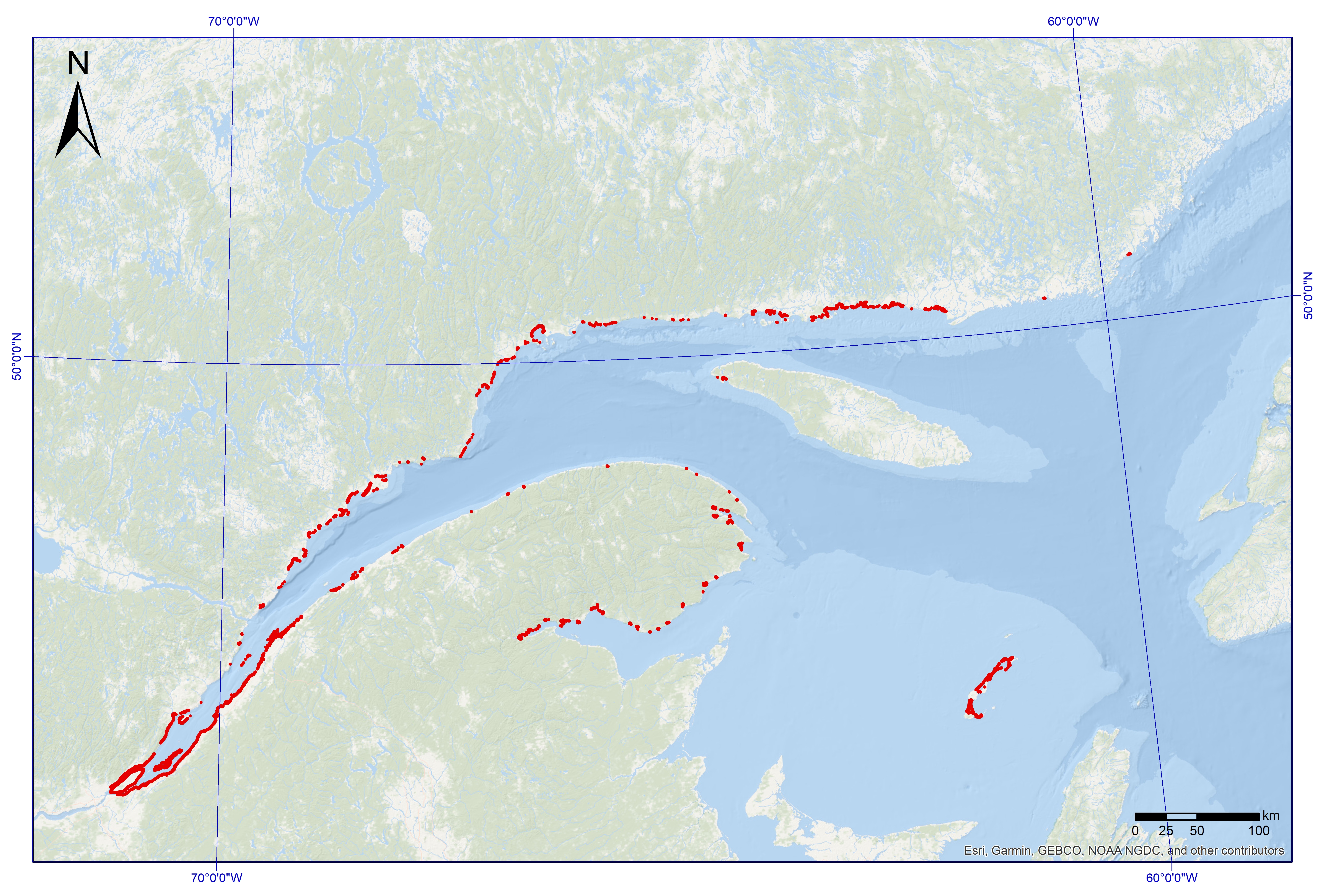
This dataset was designed for Environment and Climate Change Canada's (ECCC) National Environmental Emergencies Center (NEEC) for oil spill preparedness and response. The polygons from this layer come from the coastal ecosystems geodatabase as part of the Mapping of coastal ecosystems of the Estuary and Gulf of St. Lawrence project. This layer represents semi-vegetated (25-75%) and vegetated (75-100%) zones of which marsh vegetation is the dominant. The study area includes all of the estuarine and maritime coasts of Quebec, with the exception of certain sectors, including most of the Lower North Shore and Anticosti Island, with the exception of villages of Kegaska, la Romaine, Chevery, Blanc-Sablon and Port-Menier. Some islands off the estuary and gulf coasts are part of the region covered, such as Île d'Orléans, Isle-aux-Coudres, Île Verte and Île Bonaventure. The mapping of coastal ecosystems was carried out jointly by the Laboratory for Dynamics and Integrated Coastal Zone Management (LDGIZC) of the University of Quebec at Rimouski as part of the Coastal Resilience Project (https: //ldgizc.uqar.ca/Web/projets/projet-resilience-cotiere) funded by the MELCC; and by the Fisheries and Oceans Canada team, as part of its Integrated marine response planning (IMRP) component of the Oceans Protection Plan (OPP), with the objective of updating the Marine Oil Spill Preparedness and Response Regime of Canada. The master geodatabase of coastal ecosystems is hosted and distributed by UQAR on their SIGEC-Web mapping platform: https://ldgizc.uqar.ca/Web/sigecweb The characterization of marshes was mainly carried out using photo-interpretation of RVBI aerial photos acquired by DFO (2015-2020) and oblique photos taken by helicopter acquired by UQAR in 2017. This dataset also includes the information from validation stations visited by UQAR (2018-2020), used to validate and refine the photo-interpretation.
-

This shapefile dataset was designed using polygons extracted from the Cartography of Coastal Ecosystems of Maritime Quebec geodatabase (2022, Laboratory for Dynamics and Integrated Management of Coastal Zones, Fisheries and Oceans Canada), described in the paragraph below. It consists of polygons with eelgrass and incorporates attributes describing the vegetation cover, the composition of the seagrass beds, the associated ecosystem name, the imagery data that allowed photo-interpretation and the presence or absence of field data. A unique sequence number associated with each polygon makes it possible to trace the paired polygon of the geodatabase of coastal ecosystems to attribute values not detailed in this shapefile. The study area includes all of the estuarine and maritime coasts of Quebec, with the exception of certain sectors, including most of the Lower North Shore and Anticosti Island, with the exception of villages of Kegaska, la Romaine, Chevery, Blanc-Sablon and Port-Menier. Some islands off the estuary and gulf coasts are part of the region covered, such as Île d'Orléans, Isle-aux-Coudres, Île Verte and Île Bonaventure. The Mapping of Coastal Ecosystems of Maritime Quebec was carried out jointly by the Laboratory for Dynamics and Integrated Coastal Zone Management (LDGIZC) of the University of Quebec at Rimouski as part of the Coastal Resilience Project; and by the Fisheries and Oceans Canada team, as part of the Integrated Marine Response Planning Program (IMRP). A classification of coastal ecosystems was carried out on more than 4,200 km of coastal corridor, focusing on estuarine and maritime coasts of Quebec located between the limit of the upper foreshore and the shallow infralittoral (about 10m deep). The mapping method developed is based on semi-automated segmentation and a photo-interpretation of coastal ecosystems, using very high resolution multispectral photographs (RBVI) acquired between 2015 and 2020 by DFO. The classification of polygons is based on the assignment of predefined value classes for the biological and physical attributes under study (e.g., substrates, plant type, vegetation cover, geosystem, etc. ). Helicopter-born oblique photographs and field data helped to reduce the uncertainty associated with photo-interpretation. UQAR and DFO conducted field sampling campaigns targeting the mediolittoral (4,390 stations) and the lower mediolittoral and infralittoral zones (2,959 stations), respectively , which validated some of the attributes identified by photo-interpretation and provided detailed information on community structure . The geodatabase of the Mapping of coastal ecosystems is hosted and managed by UQAR on their SIGEC-Web cartographic platform: https://ldgizc.uqar.ca/Web/sigecweb Credits © DFO (2023, Fisheries and Oceans Canada) Provencher-Nolet, L., Paquette, L., Pitre, L.D., Grégoire, B. and Desjardins, C. 2024. Cartographie des macrophytes estuariens et marins du Québec. Rapp. Tech. Can. Sci. halieut. Aquat. 3617 : v + 99 p. Grégoire, B., Pitre, L.D., Provencher-Nolet, L., Paquette, L. and Desjardins, C. 2024. Distribution d’organismes marins de la zone côtière peu profonde du Québec recensés par imagerie sous-marine de 2017 à 2021. Rapp. tech. can. sci. halieut. aquat. 3616 : v + 78 p. Grégoire, B. 2022. Biodiversité du relevé côtier Planification pour une intervention environnementale intégrée dans l’estuaire et le golfe du Saint-Laurent (2017–2021). Observatoire global du Saint-Laurent. [Jeu de données] Jobin, A., Marquis, G., Provencher-Nolet, L., Gabaj Castrillo. M. J., Trubiano C., Drouet, M., Eustache-Létourneau, D., Drejza, S. Fraser, C. Marie, G. et P. Bernatchez (2021) Cartographie des écosystèmes côtiers du Québec maritime — Rapport méthodologique. Chaire de recherche en géoscience côtière, Laboratoire de dynamique et de gestion intégrée des zones côtières, Université du Québec à Rimouski. Rapport remis au ministère de l’Environnement et de la Lutte contre les changements climatiques, septembre 2021, 98 p.
-
The selection of an Area of Interest marks the beginning of the Oceans Act Marine Protected Area (MPA) establishment process led by Fisheries and Oceans Canada. The process includes completing detailed ecological and socioeconomic assessments, setting conservation objectives, determining boundaries and management measures, and eventually developing the regulations under section 35 of the Oceans Act. Stakeholders are involved in each step of this process. There is considerable scientific evidence that marine protected areas provide a number of ecological benefits, including the enhanced recruitment of fish species, including those of commercial value, through the protection of spawning areas, larval sources, habitats and migration routes. A well-designed MPA network can scale these benefits up to the regional level, and provide benefits that individual marine protected areas cannot provide on their own. For example, strategically placing marine protected areas in a network can protect key stops along a species’ migration route, and protect geographically distinct habitats that serve important life history functions. The United Nations Food and Agricultural Organization has recognized the use of marine protected areas as complementary to conventional fisheries management measures in helping to achieve sustainable fisheries management objectives. ----- Le choix d'un site d'intérêt marque le début du processus de création des zones de protection marines (ZPM) en vertu de la Loi sur les océans placé sous la responsabilité de Pêches et Océans Canada. Le processus comprend la réalisation d'évaluations écologiques et socioéconomiques détaillées, l'établissement d’objectifs de conservation, la détermination de limites et de mesures de gestion, et l'élaboration de règlements en vertu de l'article 35 de la Loi sur les océans. Les parties intéressées prennent part à chaque étape du processus. Les preuves scientifiques des avantages écologiques que présentent les zones de protection marines sont nombreuses. Entre autres, elles accroissent le recrutement des espèces de poisson, y compris de celles qui ont une valeur commerciale, grâce à la protection des frayères, des sources larvaires, des habitats et des routes migratoires. Un réseau de ZPM bien conçu peut décupler les avantages au niveau régional et susciter des bienfaits que les zones de protection marines ne peuvent pas procurer individuellement. Par exemple, la constitution d'un réseau de ZPM dans des zones stratégiques permet de protéger des points clés le long de la route migratoire d'une espèce et de protéger des habitats géographiques distincts qui remplissent des fonctions importantes du cycle biologique. L'Organisation des Nations Unies pour l'alimentation et l'agriculture a reconnu que l'utilisation de zones de protection marines en complément des mesures conventionnelles de gestion des pêches pouvait faciliter l'atteinte des objectifs en matière de gestion durable des pêches.
-
The selection of an Area of Interest marks the beginning of the Oceans Act Marine Protected Area (MPA) establishment process led by Fisheries and Oceans Canada. The process includes completing detailed ecological and socioeconomic assessments, setting conservation objectives, determining boundaries and management measures, and eventually developing the regulations under section 35 of the Oceans Act. Stakeholders are involved in each step of this process. There is considerable scientific evidence that marine protected areas provide a number of ecological benefits, including the enhanced recruitment of fish species, including those of commercial value, through the protection of spawning areas, larval sources, habitats and migration routes. A well-designed MPA network can scale these benefits up to the regional level, and provide benefits that individual marine protected areas cannot provide on their own. For example, strategically placing marine protected areas in a network can protect key stops along a species’ migration route, and protect geographically distinct habitats that serve important life history functions. The United Nations Food and Agricultural Organization has recognized the use of marine protected areas as complementary to conventional fisheries management measures in helping to achieve sustainable fisheries management objectives. ----- Le choix d'un site d'intérêt marque le début du processus de création des zones de protection marines (ZPM) en vertu de la Loi sur les océans placé sous la responsabilité de Pêches et Océans Canada. Le processus comprend la réalisation d'évaluations écologiques et socioéconomiques détaillées, l'établissement d’objectifs de conservation, la détermination de limites et de mesures de gestion, et l'élaboration de règlements en vertu de l'article 35 de la Loi sur les océans. Les parties intéressées prennent part à chaque étape du processus. Les preuves scientifiques des avantages écologiques que présentent les zones de protection marines sont nombreuses. Entre autres, elles accroissent le recrutement des espèces de poisson, y compris de celles qui ont une valeur commerciale, grâce à la protection des frayères, des sources larvaires, des habitats et des routes migratoires. Un réseau de ZPM bien conçu peut décupler les avantages au niveau régional et susciter des bienfaits que les zones de protection marines ne peuvent pas procurer individuellement. Par exemple, la constitution d'un réseau de ZPM dans des zones stratégiques permet de protéger des points clés le long de la route migratoire d'une espèce et de protéger des habitats géographiques distincts qui remplissent des fonctions importantes du cycle biologique. L'Organisation des Nations Unies pour l'alimentation et l'agriculture a reconnu que l'utilisation de zones de protection marines en complément des mesures conventionnelles de gestion des pêches pouvait faciliter l'atteinte des objectifs en matière de gestion durable des pêches.
-

A research survey on snow crab (Chionoecetes opilio) was conducted on the Lower North Shore of the Gulf of St. Lawrence between Havre-Saint-Pierre and Blanc-Sablon in 2018, 2022 and 2024. The main objective of this survey was to assess the abundance of snow crab and species associated with snow crab habitat. Only data for benthic and demersal species associated with snow crab habitat are presented in this dataset. Data were collected according to a fixed station sampling design. A total of of 62 stations were sampled in 2018, 54 in 2022, and 46 in 2024, between 45 and 250 meters depth. Specimens were collected using a beam trawl with a total width of 2.8 meters and a total height of 0.76 meters. The codend was lined with a 16-17 millimeter stretched mesh net in order to harvest the small individuals. The hauls were made at a target speed of 2 knots and a target duration of 10 minutes depending on seabed conditions. Start and end positions were recorded to calculate the distance traveled on each tow using the geosphere library in R. The area covered at each tow was the product of the trawl opening and the distance traveled. The two files provided (DarwinCore format) are complementary and are linked by the "eventID" key. The "Activity_Information" file includes generic activity information, including date and location. The "occurrence_taxon" file includes the taxonomy of the species observed, identified to the species or lowest possible taxonomic level. For quality controls, all taxonomic names were checked against the World Register of Marine Species (WoRMS) to match recognized standards. All sampling locations were spatially validated. Abundance and density data for crabs under different size classes are available in a joint publication https://open.canada.ca/data/en/dataset/814e48c9-2dc7-4526-bd37-a4a120d66d6e
-

This inventory, conducted from September 26th to October 3th, 2019, aimed to describe the community structure of macroalgae and benthic macroinvertebrates of five small estuaries of the Upper North Shore of Quebec, namely Barthélemy Bay and the Colombier, Mistassini, Franquelin and Saint-Nicolas rivers. This inventory is part of a doctoral study of Valentine Loiseau on the global changes in the St. Lawrence system, mainly the study of marine benthic communities in response to changes of salinity, to ensure proper management of the environment in the face of future changes. The main objective is to describe the structure and the levels of specific diversities of mediolittoral communities of benthic macroinvertebrates and macroalgae along a salinity gradient. These five small estuaries were selected because of their similar size, hard substrates and easy access. Three levels of hypoosmotic stress (low, medium, high) and one control level (seawater) were used for each of the selected estuaries, with eight quadrats per stress level. Quadrat positions were randomly selected but had to meet two criteria: (1) regular height in the foreshore to control the influence of other stresses (temperature, exposure); and (2) presence of at least one macroalga to maintain homogeneity. A percentage cover by macroalgal and macroinvertebrate species was estimated, and then all organisms were weighed by species and size group. The salinity of the nearest water point was measured at mid-tide with a portable refractometer and a Castaway-type CTD (Conductivity-Temperature-Density) probe. The inventory was done using a stratified random sampling design and the sampling unit was a quadrat measuring 25 x 25 cm. The three files provided (DarwinCore format) are complementary and are linked by the "eventID" key. The "event_information" file includes the generic information of the quadrat, including date and location. The "additional_information_event_and_occurrence" file includes salinity and substrate type of the quadrat, as well as the total weight of all individuals of the same species caught in the quadrat extrapolated to one square metre of surface. For nudibranchs and barnacles, weight was estimated from the size of the individuals so that they were not removed from the environment. The "taxon_occurrence" file includes the taxonomic inventory of macroalgal and benthic macroinvertebrate species observed in the quadrat, identified to the lowest possible species or taxonomic level and biomass by identified species. For quality control, organisms were identified on the field using the following guide: Chabot, Robert et Anne Rossignol. 2003. Algues et faune du littoral du Saint-Laurent maritime : Guide d'identification. Institut des Sciences de la mer de Rimouski, Rimouski ; Pêches et Océans Canada (Institut Maurice-Lamontagne), Mont-Joli. 113 pages. The taxonomy was checked against the World Register of Marine Species (WoRMS) to match recognized standards and using the R obistools and worrms libraries. The WoRMS match was placed in the "scientificNameID" field of the occurrence file. All sample locations were spatially validated. This project was funded by DFO Coastal Environmental Baseline Program under Canada’s Oceans Protection Plan. This initiative aims to acquire environmental baseline data contributing to the characterization of important coastal areas and to support evidence-based assessments and management decisions for preserving marine ecosystems.
-

Kelp features were taken from digitized survey source fieldsheets produced by the Canadian Hydrographic Service (CHS). The area covered by this dataset encompasses various surveyed areas along the western coast of North America in British Columbia coastal waters. CHS has an extensive collection of hydrographic survey data in the form of field sheets based on over 100 years of surveying in Canada. Data has been collected using a wide range of methods and systems, from lead-line to modern day multi-transducer and multibeam systems. Positions have been established using the different types of terrestrial systems and methods available over many years - up to the latest advanced satellite positioning systems. Fieldsheets that had not been previously digitizted were imported into ESRI ArcMap and georeferenced directly to WGS84 using CHS georeferencing standards and principles (charts.gc.ca). In order to minimize error, a hierarchy of control points was used, ranging from high survey order control points to comparing conspicuous stable rock features apparent in satellite imagery. The georeferencing result was further validated against satellite imagery, CHS charts and fieldsheets, the CHS-Pacific High Water Line (charts.gc.ca), and adjacent and overlapping Fieldsheets. Finally, the kelp features were digitized, and corresponding chart information (category of kelp, scale, source, title, year, and comments) was added as attributes to each feature. When digitizing kelp features the points were located at the optical center of the feature being digitized. This dataset includes a point and a polygon layer. Kelp that is located on land is historically valid. Symbolized kelp is not always an exact location but indicates that kelp is present in the area. The symbol is a proxy. The kelp attribute field does not distinguish between different types of kelp. The field has three variables that are kelp, seaweed and Aquatic Plants. Seaweed is the general name for marine plants of the Algae class which grow in long narrow ribbons. (International Maritime Dictionary, 2nd Ed.) Kelp is one of an order (laminariales) of usually large, blade-shaped or vine-like brown algae. (IHO Dictionary, S-32, 5th Edition, 2611) Aquatic Plants – Aquatic plants are used as to represent vegetation in fresh water rivers and lakes. Geographically encompasses the kelp in the Western Coastal waters of North America (mainly Canada) and Temporally overlaps/continues from data extracted from the British Admiralties.
-
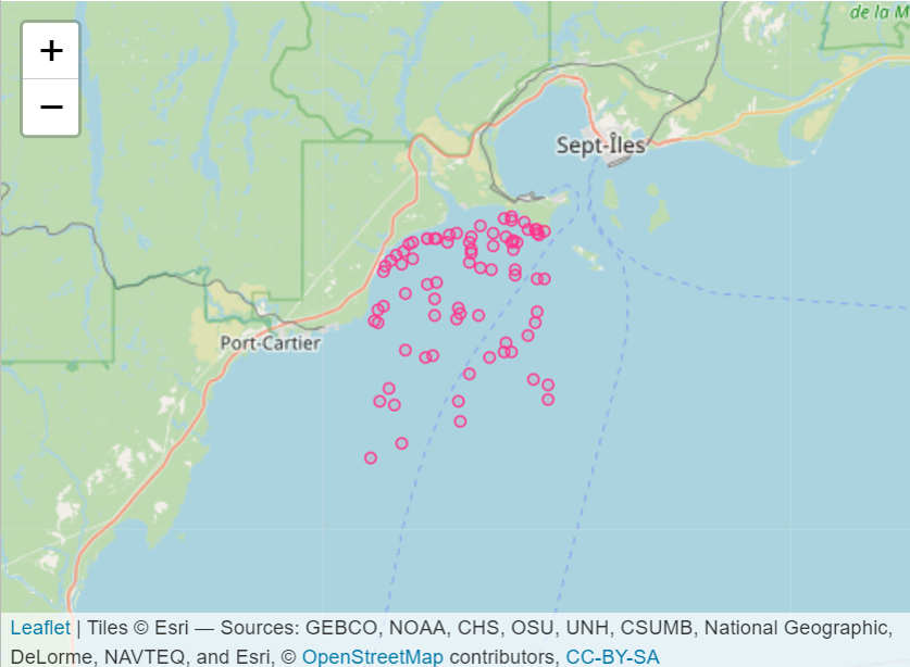
A research survey on snow crab (Chionoecetes opilio) was conducted from May 2006 to May 2009, and in July 2023, in Baie Sainte-Marguerite near Sept-Îles, Quebec. The main objective of this survey was to assess the abundance of snow crab and species associated with snow crab habitat. Only data for benthic and demersal species associated with snow crab habitat are presented in this dataset. Data were collected according to a stratified random sampling plan. A total of 79 stations was sampled from 2006 to 2009 and 36 stations in 2023, between 7 to 200 meters depth. Specimens were collected using a beam trawl with a total width of 2.8 meters and a total height of 0.76 meters. The codend was lined with a 16-17 millimeter stretched mesh net in order to harvest the small individuals. The hauls were made at a target speed of 2 knots and a target duration of 5-10 minutes depending on seabed conditions. Start and end positions were recorded to calculate the distance traveled on each tow using the geosphere library in R. The area covered at each tow was the product of the trawl opening and the distance traveled. The two files provided (DarwinCore format) are complementary and are linked by the "eventID" key. The "Activity_Information" file includes generic activity information, including date and location. The "occurrence_taxon" file includes the taxonomy of the species observed, identified to the species or lowest possible taxonomic level. For quality controls, all taxonomic names were checked against the World Register of Marine Species (WoRMS) to match recognized standards. All sampling locations were spatially validated.
-

This dataset contains the abundance (per m²) and the biomass (mg dry per m²) of macrofauna (≥ 500µm) in eelgrass and adjacent bare soft sediments, collected at sites in the Atlantic of Nova Scotia from 2009 to 2013. Cite this data as: Wong M.C. Data of Benthic invertebrates in seagrass and bare soft sediments in Atlantic Nova Scotia Published May 2020. Coastal Ecosystems Science Division, Fisheries and Oceans Canada, Dartmouth, N.S. https://open.canada.ca/data/en/dataset/05d5f46a-7f19-11ea-8a4e-1860247f53e3 Publications: Wong, M. C., & Dowd, M. (2021). Functional trait complementarity and dominance both determine benthic secondary production in temperate seagrass beds. Ecosphere. 12(11), e03794. https://doi.org/10.1002/ecs2.3794 Wong, M. C. (2018). Secondary Production of Macrobenthic Communities in Seagrass (Zostera marina, Eelgrass) Beds and Bare Soft Sediments Across Differing Environmental Conditions in Atlantic Canada. Estuaries and Coasts, 41, 536–548. https://doi.org/10.1007/s12237-017-0286-2