 Arctic SDI catalogue
Arctic ecosystems
Type of resources
Available actions
Topics
Keywords
Contact for the resource
Provided by
Formats
Representation types
Update frequencies
status
-

The Beaufort Regional Environmental Assessment-Marine Fishes Project (2012-2014) and Canadian Beaufort Sea-Marine Ecosystem Assessment (CBS-MEA, 2017-present) conducted by Fisheries and Oceans Canada provide offshore surveys of marine fishes and ecosystems on the Canadian Beaufort Shelf and slope in August and early September. The projects focus on integrating oceanography, food web linkages, physical-biological couplings and spatial and inter-annual variability, within the context of ongoing climate-driven change including enhanced Ocean Acidification. Sampling was conducted from the F/V Frosti at stations along transects spanning 20-1000 m. Zooplankton was collected using a bongo or multi-net system in conjunction with oceanographic and biogeochemical sampling.
-

In 2018, Fisheries and Oceans Canada initiated the Multidisciplinary Arctic Program (MAP) – Last Ice, the first ecosystem study of the poorly characterized region of Tuvaijuittuq, where multiyear ice still resides in the Arctic Ocean. The program MAP-Last Ice takes a coordinated approach to integrate the physical, biochemical, and ecological components of the sea ice-ocean connected ecosystem and its response to climate and ocean forcings. This program provides baseline ecological knowledge for Tuvaijuittuq and, in particular, for its unique multiyear ice ecosystem. The database provides baseline data on fatty acid composition and stable isotopes signatures of sea ice communities in multi- and first-year ice in Tuvaijuittuq. The data were collected during the 2018 spring field campaign of the MAP-Last Ice Program, offshore of Canadian Forces Station (CFS) Alert, in the Lincoln Sea.
-
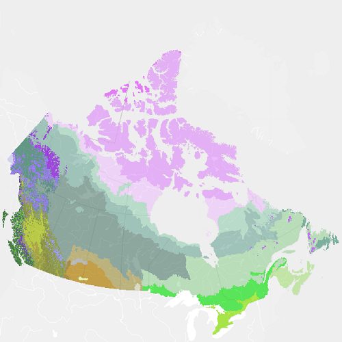
"Vegetation Zones of Canada: a Biogeoclimatic Perspective" maps Canadian geography in relation to gradients of regional climate, as expressed by potential vegetation on zonal sites. Compared to previous similar national-scale products, "Vegetation Zones of Canada" benefits from the work of provincial and territorial ecological classification programs over the last 30+ years, incorporating this regional knowledge of ecologically significant climatic gradients into a harmonized national map. This new map, reflecting vegetation and soils adapted to climates prior to approximately 1960, can serve as a broad-scale (approximately 1:5 M to 1:10 M) geospatial reference for monitoring and modeling effects of climate changes on Canadian ecosystems. "Vegetation Zones of Canada: a Biogeoclimatic Perspective" employs a two-level hierarchical legend. Level 1 vegetation zones reflect the global-scale latitudinal gradient of annual net radiation, as well as the effects of high elevation and west to east climatic and biogeographic variation across Canada. Within the level 1 vegetation zones, level 2 zones distinguish finer scale variation in zonal vegetation, especially in response to elevational and arctic climatic gradients, climate-related floristics and physiognomic diversity in the Great Plains, and maritime climatic influences on the east and west coasts. Thirty-three level 2 vegetation zones are recognized: High Arctic Sparse Tundra Mid-Arctic Dwarf Shrub Tundra Low Arctic Shrub Tundra Subarctic Alpine Tundra Western Boreal Alpine Tundra Cordilleran Alpine Tundra Pacific Alpine Tundra Eastern Alpine Tundra Subarctic Woodland-Tundra Northern Boreal Woodland Northwestern Boreal Forest West-Central Boreal Forest Eastern Boreal Forest Atlantic Maritime Heathland Pacific Maritime Rainforest Pacific Dry Forest Pacific Montane Forest Cordilleran Subboreal Forest Cordilleran Montane Forest Cordilleran Rainforest Cordilleran Dry Forest Eastern Temperate Mixed Forest Eastern Temperate Deciduous Forest Acadian Temperate Forest Rocky Mountains Foothills Parkland Great Plains Parkland Intermontane Shrub-Steppe Rocky Mountains Foothills Fescue Grassland Great Plains Fescue Grassland Great Plains Mixedgrass Grassland Central Tallgrass Grassland Cypress Hills Glaciers Please cite this dataset as: Baldwin, K.; Allen, L.; Basquill, S.; Chapman, K.; Downing, D.; Flynn, N.; MacKenzie, W.; Major, M.; Meades, W.; Meidinger, D.; Morneau, C.; Saucier, J-P.; Thorpe, J.; Uhlig, P. 2019. Vegetation Zones of Canada: a Biogeoclimatic Perspective. [Map] Scale 1:5,000,000. Natural Resources Canada, Canadian Forest Service. Great Lake Forestry Center, Sault Ste. Marie, ON, Canada.
-

PURPOSE: This Archer fiord data is associated with a larger program ArcticCORE, which was created to fulfill knowledge gaps and develop long term protection in the extremely remote Tuvaijuittuq region. The main objectives of this expedition were to improve our comprehension of the key drivers for productive capacity, diversity and ecosystem structure in areas connected to Baffin Bay and Tuvaijuittuq, including Archer fiord. DESCRIPTION: ArcticCORE is a 5-year broader program aiming to characterize Tuvaijuittuq’s unique ecosystem and its influence and connectivity with the adjacent ecosystems to inform sustainable management and conservation initiatives in Tuvaijuittuq and the eastern Arctic. In an Arctic Ocean with rapidly declining sea ice, Tuvaijuittuq area retains the oldest and thickest sea ice, and can act as a refuge for ice-dependent species. This program aims to characterize the Arctic marine ecosystem and establish baseline measurements for future comparisons in the region. From 2023, water collection was carried out at four stations throughout Archer Fiord and analyzed for primary productivity, chlorophyll a, phytoplankton flow cytometry and phytoplankton taxonomy down to the lowest identifiable level. These data will contribute to a better understanding of the key drivers for productive capacity, diversity and ecosystem structure in Archer fiord. Characterization of these upstream areas are relevant for an ecosystem-based approach to fisheries management in Baffin Bay, a priority for DFO and an intrinsic part of mandated activities, as they influence the ecosystem and fisheries resources downstream.
-

The study involved sampling during a winter subsistence fishery at Brock Lake in November 2003, and a physical, chemical and biological assessment of the lake in July 2004 and July 2005. Data including physical, chemical and biological variables were published as Roux, M.-J., Harwood, L. A., Illasiak, J., Babaluk, J.A., and de Graff, N. 2011. Fishery resources and habitats in a headwater lake of the Brock River, NT, 2003-2005. Can. Manuscr. Rep. Fish. Aquat. Sci. 2932: viii + 61 p.
-

In 2018, Fisheries and Oceans Canada initiated the Multidisciplinary Arctic Program (MAP) – Last Ice, the first ecosystem study of the poorly characterized region of the Lincoln Sea in the Marine Protected Area of Tuvaijuittuq, where multiyear ice still resides in the Arctic Ocean. MAP-Last Ice takes a coordinated approach to integrate the physical, biochemical, and ecological components of the sea ice-ocean connected ecosystem and its response to climate and ocean forcings. The cross-disciplinary program establishes baseline ecological knowledge for Tuvaijuittuq and, in particular, for its unique multiyear ice ecosystem. The database provides baseline data on the abundance of bacteria and viruses in multi- and first-year ice and in surface waters of the Lincoln Sea in Tuvaijuittuq, and their relation to bio-physical conditions. The data were collected during the 2018 spring field campaign of the MAP-Last Ice Program, at an ice camp offshore of Canadian Forces Station (CFS) Alert.
-

The contaminants in fish database is a compilation of contaminant data analysed from fish tissue at the Fresh Water Institute from 1970 to 2005. Data include lab number, region, analysis, organs, species, lake, form (whole fish, headon dressed, headless dressed), weight, and length and contaminant concentrations. Total mercury was the predominant contaminant measured. Results were expressed as ppm or ppb based on the parameter analyzed. Concentrations are expressed based on wet weight.
-
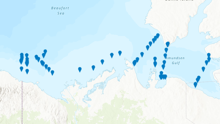
PURPOSE: From August 2nd to September 9th, 2013, Fisheries and Oceans Canada conducted a baseline survey of marine fishes and their habitats in the southern Canadian Beaufort Sea and Amundsen Gulf as part of the Beaufort Regional Environmental Assessment (BREA) called the Beaufort Sea Marine Fishes Project (BSMFP). Sampling was conducted from the F/V Frosti at 53 stations along 8 transects. Standardized sampling was conducted using benthic trawling nets. The BSMFP is the first research project to use a large research trawls to assess the biodiversity and abundance of offshore marine fishes in this area. In total, 48 species of fish were caught, one of which was a new occurrence in the Canadian Beaufort Sea, Lycodes lavalaei. DESCRIPTION: Basic biological data for all fish caught during the 2013 BSMFP expedition. Includes identification, weight, length (total, fork, and, standard), liver weight, gonad weight, sex and maturity level. PARAMETERS COLLECTED: family species weight total length fork length standard length liver weight gonad weight sex maturity SAMPLING METHODS: Various trawl types.
-

Basic biological data for all fish caught during the 2012 BSMFP expedition. Includes identification, weight, length (total, fork, and, standard), liver weight, gonad weight, sex and maturity level.