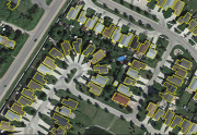
Automatic Extraction
Type of resources
Available actions
Topics
Keywords
Contact for the resource
Provided by
Formats
Representation types
Update frequencies
status
-

“Automatically Extracted Buildings” is a raw digital product in vector format created by NRCan. It consists of a single topographical feature class that delineates polygonal building footprints automatically extracted from airborne Lidar data, high-resolution optical imagery or other sources.
-
GeoAI are buildings, hydrography, forests, and roads automatically extracted using Deep Learning models applied to a source dataset, typically aerial or satellite images. The primary aim of GeoAI is to increase Canada's availability of high-resolution foundational geospatial data for both spatial and temporal coverage. The infrastructure and expertise put in place by NRCan enables a rapid, efficient, and scalable data creation process through the use of leading-edge technology and Artificial Intelligence models. Published datasets for a given source can be revisited at a later date as more accurate models are developed and put into production. For now, only static files are available, but as the series develops, new products and services will be added.
 Arctic SDI catalogue