 Arctic SDI catalogue
Facility
Type of resources
Available actions
Topics
Keywords
Contact for the resource
Provided by
Formats
Representation types
Update frequencies
status
-
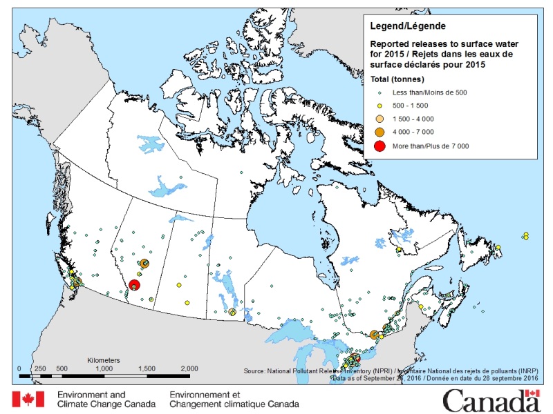
The National Pollutant Release Inventory (NPRI) is Canada's public inventory of pollutant releases (to air, water and land), disposals and transfers for recycling. The files below contain a map of Canada showing the locations of all facilities that reported direct releases to surface waters to the NPRI. The data are for the most recent reporting year, by reported total quantities of these releases. The map is available in both ESRI REST (to use with ARC GIS) and WMS (open source) formats. For more information about the individual reporting facilities, a dataset is available in a CSV format. Please consult the following resources to enhance your analysis: - Guide on using and Interpreting NPRI Data: https://www.canada.ca/en/environment-climate-change/services/national-pollutant-release-inventory/using-interpreting-data.html - Access additional data from the NPRI, including datasets and mapping products: https://www.canada.ca/en/environment-climate-change/services/national-pollutant-release-inventory/tools-resources-data/exploredata.html
-
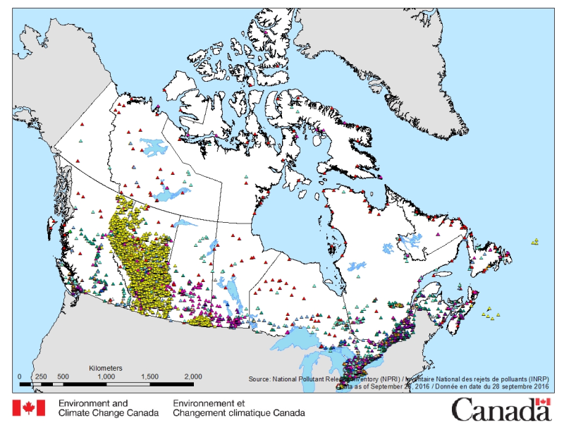
The National Pollutant Release Inventory (NPRI) is Canada's public inventory of pollutant releases (to air, water and land), disposals and transfers for recycling. The files below contain a map of Canada showing the locations of all facilities that reported to the NPRI in the most recent reporting year. The map is available in both ESRI REST (to use with ARC GIS) and WMS (open source) formats. For more information about the individual reporting facilities, datasets are available in either CSV or XLS formats. Please consult the following resources to enhance your analysis: - Guide on using and Interpreting NPRI Data: https://www.canada.ca/en/environment-climate-change/services/national-pollutant-release-inventory/using-interpreting-data.html - Access additional data from the NPRI, including datasets and mapping products: https://www.canada.ca/en/environment-climate-change/services/national-pollutant-release-inventory/tools-resources-data/exploredata.html
-
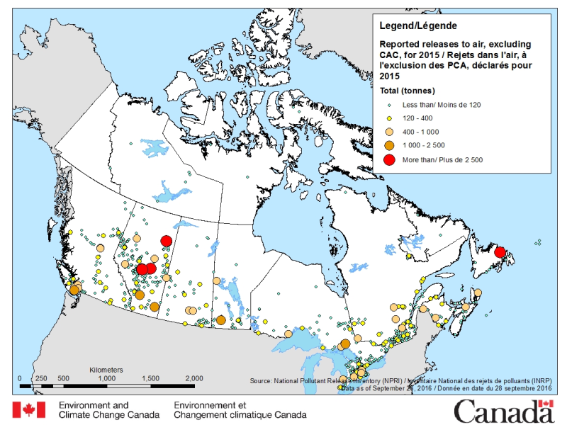
The National Pollutant Release Inventory (NPRI) is Canada's public inventory of pollutant releases (to air, water and land), disposals and transfers for recycling. The files below contain a map of Canada showing the locations of all facilities that reported releases to air (other than Criteria Air Contaminants (CAC)) to the NPRI. The data are for the most recent reporting year, by reported total quantities of these releases. The map is available in both ESRI REST (to use with ARC GIS) and WMS (open source) formats. For more information about the individual reporting facilities, a dataset is available in a CSV format. Please consult the following resources to enhance your analysis: - Guide on using and Interpreting NPRI Data: https://www.canada.ca/en/environment-climate-change/services/national-pollutant-release-inventory/using-interpreting-data.html - Access additional data from the NPRI, including datasets and mapping products: https://www.canada.ca/en/environment-climate-change/services/national-pollutant-release-inventory/tools-resources-data/exploredata.html
-
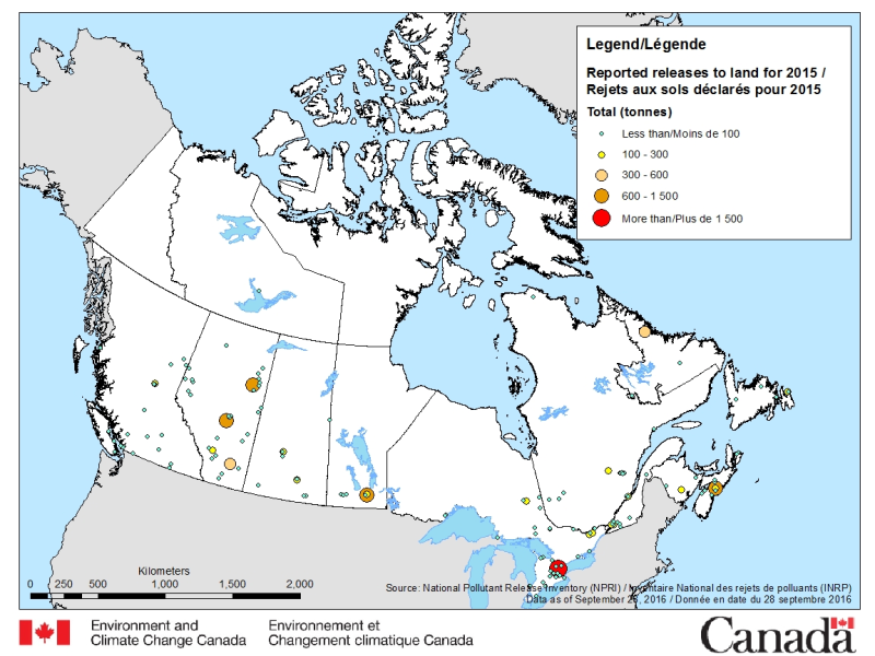
The National Pollutant Release Inventory (NPRI) is Canada's public inventory of pollutant releases (to air, water and land), disposals and transfers for recycling. The files below contain a map of Canada showing the locations of all facilities that reported direct releases to land to the NPRI. The data are for the most recent reporting year, by reported total quantities of these releases. The map is available in both ESRI REST (to use with ARC GIS) and WMS (open source) formats. For more information about the individual reporting facilities, a dataset is available in a CSV format. Please consult the following resources to enhance your analysis: - Guide on using and Interpreting NPRI Data: https://www.canada.ca/en/environment-climate-change/services/national-pollutant-release-inventory/using-interpreting-data.html - Access additional data from the NPRI, including datasets and mapping products: https://www.canada.ca/en/environment-climate-change/services/national-pollutant-release-inventory/tools-resources-data/exploredata.html
-

Facilities are an oil and gas activity, defined in the Energy Resources Activities Act as a system of vessels, piping, valves, tanks and other equipment used to gather, process, measure, store or dispose of petroleum, natural gas, water or a substance referred to in paragraph (d) or (e) of the definition of pipeline. This dataset contains point features for proposed applications collected through the BC Energy Regulator's Application Management System (AMS). This dataset is updated nightly.
-
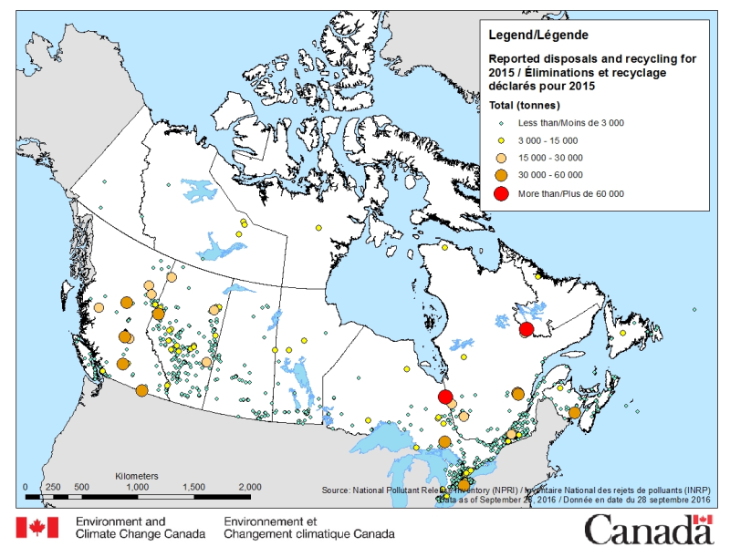
The National Pollutant Release Inventory (NPRI) is Canada's public inventory of pollutant releases (to air, water and land), disposals and transfers for recycling. The files below contain a map of Canada showing the locations of all facilities that reported disposals and transfers to the NPRI in the most recent reporting year, by reported total quantities. The map is available in both ESRI REST (to use with ARC GIS) and WMS (open source) formats. For more information about the individual reporting facilities, a dataset is available in an csv format. Please consult the following resources to enhance your analysis: - Guide on using and Interpreting NPRI Data: https://www.canada.ca/en/environment-climate-change/services/national-pollutant-release-inventory/using-interpreting-data.html - Access additional data from the NPRI, including datasets and mapping products: https://www.canada.ca/en/environment-climate-change/services/national-pollutant-release-inventory/tools-resources-data/exploredata.html
-

The National Pollutant Release Inventory (NPRI) is Canada's public inventory of pollutant releases (to air, water and land), disposals and transfers for recycling. Each file contains the NPRI map layers in a KMZ format that you can use with virtual globe software such as Google Earth™. Data are available for the last two reporting years. You can filter the data by province or industry type. Select a facility to view a report that summarizes its pollutant releases, disposals and transfers. Please consult the following resources to enhance your analysis: - Guide on using and Interpreting NPRI Data: https://www.canada.ca/en/environment-climate-change/services/national-pollutant-release-inventory/using-interpreting-data.html - Access additional data from the NPRI, including datasets and mapping products: https://www.canada.ca/en/environment-climate-change/services/national-pollutant-release-inventory/tools-resources-data/exploredata.html
-

An interactive web map illustrating the current state of Emergency Medical Service (EMS) Facilities in Manitoba outside the Winnipeg Regional Health Authority. An interactive web map illustrating the current state of Emergency Medical Service (EMS) Facilities in Manitoba outside the Winnipeg Regional Health Authority, as well as both the daytime and night time catchment areas of rural EMS Facilities south of 53°N. The map includes points representing the current locations of EMS facilities. Polygons representing daytime or night time drive time catchment areas (9, 15, and 30 minutes) for each EMS facility are also shown, including the approximate population served (Statistics Canada 2011 census data) and incident responses (2015/16 data) within each catchment area . Note that this information is only available for rural Manitoba and areas south of 53°N. Pop-ups for the current EMS Facilities display the following information: Community Name Facility Name Pop-ups for the current catchment areas display the following information: Community Name Facility Name Total Population in 9, 15, and 30 minute night time catchment areas (south of 53°N only) Total Incidents ((2015/16) in 9, 15, and 30 minute night time catchment areas (south of 53°N only)
-
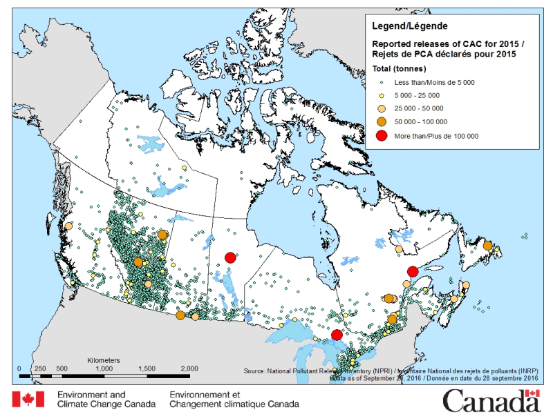
The National Pollutant Release Inventory (NPRI) is Canada's public inventory of pollutant releases (to air, water and land), disposals and transfers for recycling. The files below contain a map of Canada showing the locations of all facilities that reported direct releases of Criteria Air Contaminants to the NPRI. The data are for the most recent reporting year, by reported total quantities of these releases. The map is available in both ESRI REST (to use with ARC GIS) and WMS (open source) formats. For more information about the individual reporting facilities, a dataset is available in a CSV format. Please consult the following resources to enhance your analysis: - Guide on using and Interpreting NPRI Data: https://www.canada.ca/en/environment-climate-change/services/national-pollutant-release-inventory/using-interpreting-data.html - Access additional data from the NPRI, including datasets and mapping products: https://www.canada.ca/en/environment-climate-change/services/national-pollutant-release-inventory/tools-resources-data/exploredata.html
-
An interactive web map illustrating the future state of Emergency Medical Service (EMS) Facilities in Manitoba outside the Winnipeg Regional Health Authority. An interactive web map illustrating the future state of Emergency Medical Service (EMS) Facilities in Manitoba outside the Winnipeg Regional Health Authority. The map includes points representing the future locations of EMS facilities. Polygons representing drive time catchment areas (9, 15, and 30 minutes) for each EMS facility are also shown, including the approximate population served (Statistics Canada 2011 census data) and incident responses (2015/16 data) within each catchment area . Note that this information is only available for rural Manitoba and areas south of 53°N. Pop-ups for the future EMS Facilities display the following information: Community Name Facility Name Pop-ups for the future catchment areas display the following information: Community Name Facility Name Total Population in 9, 15, and 30 minute night time catchment areas (south of 53°N only) Total Incidents ((2015/16) in 9, 15, and 30 minute night time catchment areas (south of 53°N only)