 Arctic SDI catalogue
Air
Type of resources
Available actions
Topics
Keywords
Contact for the resource
Provided by
Years
Formats
Representation types
Update frequencies
status
Service types
-

Under the Regulation Respecting the Mandatory Reporting of Certain Contaminant Emissions into the Atmosphere (RDOECA), the Ministère de l'Environnement et de la Lutte contre les Changements Climates de la Faune et des Parcs collects data on air contaminants emitted by Quebec businesses in particular. Thus, any person or municipality operating an establishment that emits air contaminants above thresholds into the atmosphere is required to report its emissions no later than June 1 of each year. This dataset includes emissions of air contaminants reported under RDOECA or voluntarily expressed in metric tons, with the exception of dioxin and furan emissions, which are expressed in metric tons of toxic equivalents.**This third party metadata element was translated using an automated translation tool (Amazon Translate).**
-
The Canadian Environmental Sustainability Indicators (CESI) program provides data and information to track Canada's performance on key environmental sustainability issues. These indicators track human-related emissions to air of 3 substances (mercury, lead and cadmium) and facility-based emissions to air of 1 substance (arsenic). The 4 substances are defined as toxic under the Canadian Environmental Protection Act, 1999. For each substance, data are provided at the national, regional (provincial and territorial) and facility level, and by source. Global emissions data are also provided for mercury. The indicators inform Canadians about emissions of mercury, lead and cadmium to air from human activity and emissions of arsenic from facility-based reporting in Canada. These indicators also help the government to identify priorities and develop or revise strategies to inform further risk management and to track progress on policies put in place to reduce or control these 4 substances and air pollution in general. Information is provided to Canadians in a number of formats including: static and interactive maps, charts and graphs, HTML and CSV data tables and downloadable reports. See the supplementary documentation for the data sources and details on how the data were collected and how the indicator was calculated. Canadian Environmental Sustainability Indicators: https://www.canada.ca/environmental-indicators
-

The Air Quality Health Index (AQHI) is a scale designed to help quantify the quality of the air in a certain region on a scale from 1 to 10. When the amount of air pollution is very high, the number is reported as 10+. It also includes a category that describes the health risk associated with the index reading (e.g. Low, Moderate, High, or Very High Health Risk). The AQHI is calculated based on the relative risks of a combination of common air pollutants that are known to harm human health, including ground-level ozone, particulate matter, and nitrogen dioxide. The AQHI formulation captures only the short term or acute health risk (exposure of hour or days at a maximum). The formulation of the AQHI may change over time to reflect new understanding associated with air pollution health effects. The AQHI is calculated from data observed in real time, without being verified (quality control).
-
The Canadian Environmental Sustainability Indicators (CESI) program provides data and information to track Canada's performance on key environmental sustainability issues. These indicators track human-related emissions to air of 3 substances (mercury, lead and cadmium) and facility-based emissions to air of 1 substance (arsenic). The 4 substances are defined as toxic under the Canadian Environmental Protection Act, 1999. For each substance, data are provided at the national, regional (provincial and territorial) and facility level, and by source. Global emissions data are also provided for mercury. The indicators inform Canadians about emissions of mercury, lead and cadmium to air from human activity and emissions of arsenic from facility-based reporting in Canada. These indicators also help the government to identify priorities and develop or revise strategies to inform further risk management and to track progress on policies put in place to reduce or control these 4 substances and air pollution in general. Information is provided to Canadians in a number of formats including: static and interactive maps, charts and graphs, HTML and CSV data tables and downloadable reports. See the supplementary documentation for the data sources and details on how the data were collected and how the indicator was calculated. Canadian Environmental Sustainability Indicators: https://www.canada.ca/environmental-indicators
-
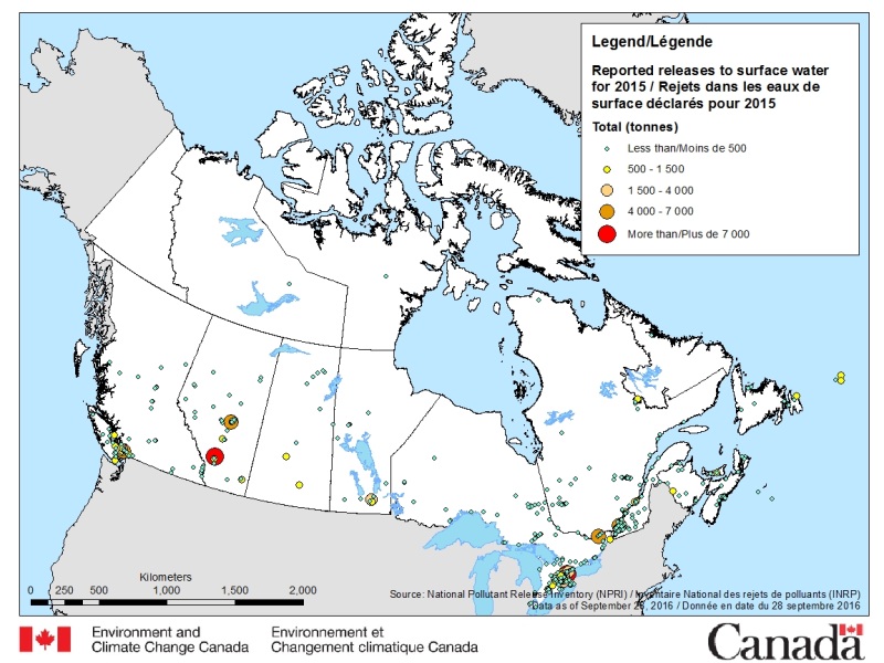
The National Pollutant Release Inventory (NPRI) is Canada's public inventory of pollutant releases (to air, water and land), disposals and transfers for recycling. The files below contain a map of Canada showing the locations of all facilities that reported direct releases to surface waters to the NPRI. The data are for the most recent reporting year, by reported total quantities of these releases. The map is available in both ESRI REST (to use with ARC GIS) and WMS (open source) formats. For more information about the individual reporting facilities, a dataset is available in a CSV format. Please consult the following resources to enhance your analysis: - Guide on using and Interpreting NPRI Data: https://www.canada.ca/en/environment-climate-change/services/national-pollutant-release-inventory/using-interpreting-data.html - Access additional data from the NPRI, including datasets and mapping products: https://www.canada.ca/en/environment-climate-change/services/national-pollutant-release-inventory/tools-resources-data/exploredata.html
-
Air Monitoring Networks and Studies produce data that represent a wide variety of observations and measurements. Multiple data types (also called collections) can be produced by a single network and data collections can have contributions from multiple networks. The data are organised as follows: 1. Atmospheric Gases, 2. Atmospheric Particles, 3. Atmospheric Precipitation Chemistry, 4. Combined Atmospheric Gases and Particles 5. Special Studies of Atmospheric Gases, Particles and Precipitation Chemistry Networks and Studies contributing to the Canadian National Atmospheric Chemistry Database and Analysis system (NAtChem) are from Canadian federal and provincial networks (past and present) and also include U.S. historical networks (these data are not available elsewhere). Information about these contributing networks, for each of these collection and product groups, can be found in each network's description documentation.
-
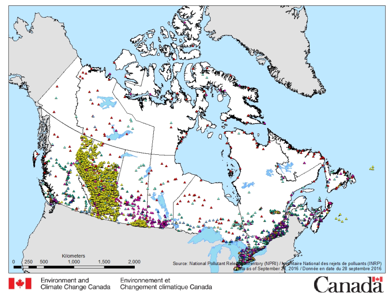
The National Pollutant Release Inventory (NPRI) is Canada's public inventory of pollutant releases (to air, water and land), disposals and transfers for recycling. The files below contain a map of Canada showing the locations of all facilities that reported to the NPRI in the most recent reporting year. The map is available in both ESRI REST (to use with ARC GIS) and WMS (open source) formats. For more information about the individual reporting facilities, datasets are available in either CSV or XLS formats. Please consult the following resources to enhance your analysis: - Guide on using and Interpreting NPRI Data: https://www.canada.ca/en/environment-climate-change/services/national-pollutant-release-inventory/using-interpreting-data.html - Access additional data from the NPRI, including datasets and mapping products: https://www.canada.ca/en/environment-climate-change/services/national-pollutant-release-inventory/tools-resources-data/exploredata.html