 Arctic SDI catalogue
Fishery
Type of resources
Available actions
Topics
Keywords
Contact for the resource
Provided by
Years
Formats
Representation types
Update frequencies
status
-

The Gulf of St. Lawrence At-Sea Observer Program is part of the Fisheries Monitoring Policy of the Department of Fisheries and Oceans Canada (DFO) (https://www.dfo-mpo.gc.ca/reports-rapports/regs/sff-cpd/fishery-monitoring-surveillance-des-peches-eng.htm#toc13). Its purpose is to ensure accurate verification of fishing activities at sea by an independent third party, and to provide DFO with scientific data on catches. The fishing industry and DFO depend on the proper communication of this information for fisheries management, monitoring and scientific research activities. Biological data on fish and marine invertebrates collected by the At-Sea Observer Program is one of the sources of information used by DFO to assess the status of these resources. Biological data protocols are the subject of an annual consultation with the biologists responsible for assessing each of the exploited stocks. This dataset contains the sum of weight data for species caught, by NAFO (Northwest Atlantic Fisheries Organization) sub-division and by year from 1999-2023, from commercial species directed fisheries for stock assessments in the Quebec region. It also includes length frequencies for species caught when required by protocol. To preserve the confidentiality of the fishing industry, data are only presented when fishing activity has been observed on a minimum of 5 vessels in a given NAFO area. The data presented are raw and should be interpreted with caution. They may contain errors such as spatial coordinates, landing weights or inaccurate or unreliable species identifications. A brief review of the taxonomy was carried out by DFO taxonomist cited as collaborator. His comments can be found in the “REMARK_IDENT” column preceded by the code “Claude_Nozere”.
-
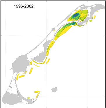
This cartographic dataset of areas of importance for spring herring in the Magdalen Islands was produced by Fisheries and Oceans Canada (DFO) and the Magdalen Islands ZIP Committee, as part of the work to characterize the Magdalen Islands Lagoons Marine Refuge. The initiative aimed to document fishermen's ecological knowledge of spring herring, including good fishing areas and spawning grounds around the archipelago. The data comes from interviews conducted between January and April 2024 with the most experienced fishermen in the archipelago. During the interviews, participants identified directly on digital maps the locations associated with four types of observations made throughout their careers: • Question 8 — Good fishing sites; • Question 9 — Other observations of high concentrations of the resource; • Question 13a — Spawning areas and; • Question 13b — Other observations of signs of spawning. To facilitate temporal contextualization, a four-period timeline (before 1996, 1996-2002, 2003-2006, and 2007-2021) was used. The final product is a GeoPackage (.gpkg) containing 16 vector layers composed of four layers per observation type, each corresponding to one of the defined time periods. The polygons were classified according to the number of fishermen who reported each location, making it possible to assess the degree of overlap and the relative importance of the areas over time. The data are projected in NAD83 / MTM zone 4. For more information on the methodology and data, see Burbank et al. (2025). Additional information specific to the Magdalen Islands lagoons is presented in Grégoire et al. (2026).
-
Områden som är av riksintresse för yrkesfisket är utpekade inom havsområde, sjöar och vattendrag samt för fiskehamnar. Havs- och vattenmyndigheten lämnar uppgifter om områden som är av riksintresse för yrkesfiske enligt Miljöbalkens bestämmelser om riksintresse, MB 3 kap. 5§. Tillämpning av hushållningsbestämmelserna i MB 3 kap. 5 § innebär att planeringen för användning av mark- och vattenområden ska säkerställa fiskesektorns tillgång till fångstområden i både havet och inlandsvatten. Det är också avgörande att planeringen säkerställer nödvändig infrastruktur av hamnar med service för fiskefartygen och som erbjuder lämpliga möjligheter för landning av fångsten. Boverket anger i sin vägledning till riksintressemyndigheterna tre generella kriterier. De områden som anges som riksintresse för yrkesfiske uppfyller sammantaget dessa kriterier: 1. området hyser värden av stor nationell vikt 2. området behövs för att uppfylla Sveriges internationella åtaganden eller 3. området behövs för att genomföra eller upprätthålla nationellt viktiga strukturer.
-
Hanteringsområdet omfattar den del av Sverige där signalkräfta i huvudsak finns etablerad och där den enligt HaV kan fortsätta att nyttjas genom fiske. Syftet är att visa var fiske får bedrivas förutsatt att signalkräftan inte sprids. Utanför hanteringsområdet är hantering, inklusive fiske straffbar. Därmed är det viktigt att detaljerade gränser finns. Informationsmängden omfattar gränser bestående av kommun- och länsgränser, riksvägar och gränser för delavrinningsområden.