 Arctic SDI catalogue
Frontière
Type of resources
Available actions
Keywords
Contact for the resource
Provided by
Years
Formats
Representation types
Update frequencies
status
Service types
Scale
-
The National Parks and National Park Reserves of Canada Legislative Boundaries web service includes the following lands: 1) National Parks of Canada as defined in Schedule 1 of the Canada National Parks Act, 2) National Park Reserves of Canada as defined in Schedule 2 of the Canada National Parks Act, 3) Rouge National Urban Park as defined in the Rouge National Urban Park Act and 4) Saguenay–St. Lawrence Marine Park as defined in the Saguenay-St. Lawrence Marine Park Act. The Data available for download is the former National Framework Canada Lands Administrative Boundaries Level 1 product. There are some attribute differences between the data available for download and the web service; however both contain the same underlying data. Please refer to the Supporting Documents for additional information on the National Framework Canada Lands Administrative Boundaries Level 1 dataset. Work is under way to align these two data products. As well, the Comprehensive Claims Settlement Areas have been removed from this dataset, but can be obtained from the Post-1975 Treaties (Modern Treaties) dataset produced by Indigenous and Northern Affairs Canada.
-
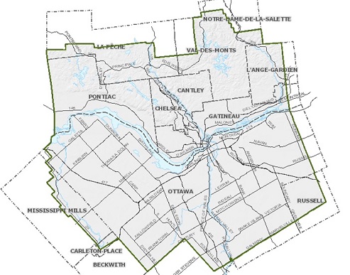
Boundaries of the National Capital Region since 1959, with the coming into force of the National Capital Act
-

This map presents the history of the political boundaries in Canada, from Confederation in 1867 to 2017. Canada’s boundaries are dynamic political structures that reflect the changing political, economic, and cultural conditions of the country through time. Canada’s long and diversified settlement history is reflected in the two distinct patterns of boundaries that differentiate eastern and western Canada. In the east, the evolution of the Atlantic provinces’ boundaries are the outcome of 200 years of colonial competition for both land and resources. Similarly, Quebec and Ontario grew from frontier settlements to industrialized economies between 1760 and the early 1900s. As well, in the boundaries of eastern Canada closely conform to natural features such as drainage basins. In contrast, the boundaries of western and northern Canada reflect the administrative organization of these lands by, first, the Hudson’s Bay Company and, later, the Government of Canada. Here, geometric lines radiate northward from the 49th parallel, creating boundaries that often divide communities and regions into two different provincial jurisdictions. Each of the western provinces has a unique history and rationale for their boundaries. Manitoba evolved from the first Riel Rebellion as a "postage stamp" province, and only later achieved its present-day boundaries. Alberta and Saskatchewan earned provincial status with an eye to creating equal land areas. On the Pacific coast, the British colonies had to act quickly in response to the explosive gold mining frontier to organize and solidify their territorial claims to present-day British Columbia, and later to help establish the Yukon Territory in response to American encroachment. In the North, the boundaries of the existing Territories were redrawn in 1999 to create Nunavut. The boundaries of this new territory respect the traditional Aboriginal concept of territoriality. This online interactive map relies on the emerging "MapML" standard co-developed by Natural Resources Canada. The objective of this evolving standard is to make it simple for beginners and experts alike to create maps in Web pages that use open data and map services.
-

The Environmental Studies Research Fund (ESRF) Regions are legally described in Part I and Part II of the Schedule in the Environmental Studies Research Fund Regions Regulations in the Canada Petroleum Resources Act. This data collection is for illustrative purposes only and includes: • 1 dataset illustrating ESRF prescribed regions 1 to 31 as they are described in the ESRF Regions Regulations. • 1 dataset illustrating the areas where levies are no longer applied to ESRF prescribed regions. These areas include lands that are described in the ESRF Regions Regulations but have since been devolved to the Government of Yukon or the Government of Northwest Territories as part of the 2003 Yukon Devolution and 2014 Northwest Territories Devolution, respectively. Once the Yukon Act and Northwest Territories Act came into effect, lands subject to devolution were no longer considered frontier lands or Canada lands, and therefore no longer subject to ESRF levies under the Canada Petroleum Resources Act. The geospatial extents used in this dataset represent those identified in the Devolution Agreements. Future updates to Part II, section 3 of the Schedule in the ESRF Regions Regulations will reflect the Yukon and Northwest Territories Devolutions. • 3 maps (National, North, South). • 1 table compiling the historical levies for each ESRF prescribed region. Context: The Environmental Studies Research Fund (ESRF) is a research program which sponsors environmental and social studies designed to assist in the decision-making process related to oil and gas exploration and development on Canada's frontier lands. The ESRF is directed by a 12-member Management Board which includes representation from the federal government, the Canada-Newfoundland and Labrador Offshore Petroleum Board (C-NLOPB), the Canada-Nova Scotia Offshore Energy Regulator (CNSOER), the oil and gas industry, and the public. The ESRF is administered by a secretariat which resides in the Offshore Management Division in Natural Resources Canada. Since 1987, the ESRF has received its legislative mandate through the Canada Petroleum Resources Act. The ESRF regions are described in the Environmental Studies Research Fund Regions Regulations. As well, the Canada-Newfoundland and Labrador Atlantic Accord Implementation Act and the Canada–Nova Scotia Offshore Petroleum Resources Accord Implementation and Offshore Renewable Energy Management Act provide legislative direction in the southern ESRF regions. Funding for ESRF is collected annually through levies paid by lease-holding oil and gas companies active in a specific ESRF region. In accordance with the legislation, levies are recommended by the Management Board to the Ministers of Natural Resources and Crown-Indigenous Relations and Northern Affairs for approval. Levies in the southern regions in areas governed by an offshore Accord are subject to final approval by the respective offshore regulator (i.e., the C-NLOPB, or the CNSOER). Levies are calculated by multiplying the levy rate of a region by the number of hectares of land under lease. The ESRF has sponsored studies on biodiversity; environmental effects and monitoring; social and economic issues; ice, icebergs, and ice detection; oil spill research and countermeasures; sea bottom ice scour; sediment transport; Indigenous Knowledge; and waves.
-
Cartographic representations of Fisheries Management Areas (FMA)s in the Atlantic and Arctic Regions. Currently Published Fisheries Management Areas: Capelin Crab Herring Mackerel Salmon, Atlantic Scallop Shrimp Snow Crab Squid Each polygon feature class delineates the coordinates of a different series of FMAs. Shapes have been drafted based on a combination of sources including: the Atlantic Fisheries Regulations, Integrated Fisheries Management Plans, indigenous treaties, the bounds of the Territorial Sea, and other information made public on Fisheries and Oceans websites. Information from Variation orders and Conditions of License were also incorporated. The specific sources used to construct each feature class is listed in its metadata and direct links to public sources are included. The original documentation uses a diverse combination datums, or include coordinates with no listed datum. This data series has been projected into NAD83. Vertices in this dataset may differ from the original source documents to fix slivers, make areas congruent with coastlines, or align with other administrative boundaries. Changes made to the original areas in order to make drafting possible have been highlighted in the comments field in the attribute tables. Lines were first drafted as geodesics and vertices were added to approximate loxodromes using the Construct Geodesic Tool in ArcGIS Pro 2.9.8. As documentation is drafted, additional FMAs will be added to the dataset. Currently drafted FMAs my change and expand into currently unmapped areas as new information is incorporated. The feature classes produced as a part of this data series are cartographic representations of legal documents and are meant to be used for general reference in support of marine planning. Whenever there is a difference between the original written source documentation and this digital representation, the originals should be considered authoritative. Every effort has been made to ensure that these files are as accurate as possible but these feature classes are not intended to be used for navigation, legal interpretation or enforcement.
-

There are fourteen major and four minor field trial regions in Canada and USA. Each of these regions recognizes physical characteristics, such as soils, and crops and climate, that make the region unique. The subzones address differences within a region, generally reflected in the types of crops grown in that region. The Canadian regions, as much as possible, correspond to the U.S. regions. The trial regions contain number of field trials by specific crop.
-
The Canadian major and minor crop field trial regions were developed following extensive stakeholder consultation and have been harmonized between the Pest Management Regulatory Agency (PMRA) and the Environmental Protection Agency of the USA. The identified regions are used for experimental studies in support of residue chemistry data requirements for the registration of new pesticide uses. The regions are based on soil type and climate and do not correspond to plant hardiness zones.
-

Group of neighbouring municipalities joined together for the purposes of regional planning and managing common services (such as police or ambulance services). These groupings are established under laws in effect in certain provinces of Canada. Census division (CD) is the general term for provincially legislated areas (such as county, municipalité régionale de comté and regional district) or their equivalents. In other provinces and the territories where laws do not provide for such areas, Statistics Canada defines equivalent areas for statistical reporting purposes in cooperation with these provinces and territories. Census divisions are intermediate geographic areas between the province/territory level and the municipality (census subdivision). Census divisions (CD) have been established in provincial law to facilitate regional planning, as well as the provision of services that can be more effectively delivered on a scale larger than a municipality. In Newfoundland and Labrador, Manitoba, Saskatchewan, Alberta, Yukon, Northwest Territories and Nunavut, provincial or territorial law does not provide for these administrative geographic areas. Therefore, Statistics Canada, in cooperation with these provinces and territories, has created equivalent areas called CDs for the purpose of disseminating statistical data. In Yukon, the CD is equivalent to the entire territory. Next to provinces and territories, census divisions (CD) are the most stable administrative geographic areas, and are therefore often used in longitudinal analysis.
-

Census subdivision (CSD) is the general term for municipalities (as determined by provincial/territorial legislation) or areas treated as municipal equivalents for statistical purposes (e.g., Indian reserves, Indian settlements and unorganized territories). Municipal status is defined by laws in effect in each province and territory in Canada. Census subdivisions (CSDs) are classified into 53 types according to official designations adopted by provincial/territorial or federal authorities. Two exceptions are 'subdivision of unorganized' (SNO) in Newfoundland and Labrador, and 'subdivision of county municipality' (SC) in Nova Scotia, which are geographic areas created as equivalents for municipalities by Statistics Canada, in cooperation with those provinces, for the purpose of disseminating statistical data. The census subdivision type accompanies the census subdivision name in order to distinguish CSDs from each other, for example, Balmoral, VL (for the village of Balmoral) and Balmoral, P (for the parish / paroisse (municipalité de) of Balmoral).
-
The Atlas of Canada Base Maps provide coverage of the entire Canadian landmass. Data elements are feature coded and structurally clean. Base map components are available in five scales and a number of data exchange formats. The 1:2 million and 1:7.5 million scales are the primary bases for all Atlas products. The 1:30 million scale data have been generalized from the two larger scales. The data set covers: drainage (coastlines, rivers, lakes), boundaries (federal, provincial, district, dividing lines), transportation (primary and secondary highways, selected ferry routes, rail networks), populated places, national parks. Atlas information is two-dimensional layered vector data.