 Arctic SDI catalogue
Carte
Type of resources
Available actions
Topics
Keywords
Contact for the resource
Provided by
Years
Formats
Representation types
Update frequencies
status
Service types
Scale
-

The Canada Centre for Mapping and Earth Observation (CCMEO) has created a 30m resolution radar mosaic of Canada's landmass from the RADARSAT Constellation Mission (RCM). This product highlights different types of radar interaction with the surface, which can assist the interpretation and study of land cover on a national scale. The national mosaic is made up of 3222 RCM images acquired between August 2023 and February 2024. (Credit: RADARSAT Constellation Mission imagery © Government of Canada [2024]. RADARSAT is an official mark of the CSA.)
-
Satellite-Based Forest Inventory (SBFI) informing on Canada's forested land cover, disturbance recovery, structure, species, stand age from 2020, and stand-replacing disturbances from 1985-2020. It is developed within the framework of Canada’s National Terrestrial Ecosystem Monitoring System (NTEMS). The SBFI polygons represent homogeneous forest conditions akin to those of stands delineated in a strategic forest inventory. Over 25 million SBFI polygons were delineated using a multiresolution segmentation algorithm applied to the 2020 Landsat surface-reflectance BAP image composite (30-m spatial resolution), fire year, and harvest year layers derived from Landsat with the C2C approach. A minimum map unit of 0.45 ha (5 pixels) was used to define polygons. The entirety of Canada's forest ecosystems were mapped using the same data, attributes, and temporal representation, resulting in a common vegetation inventory system of Canada's ~650 Mha forested ecosystems. Given the large and diverse forest area of Canada, the strength of an SBFI lies in its use of a consistent data source and methodology across jurisdictional boundaries, and across managed and unmanaged forest areas, enabling consistently generated synoptic, spatially explicit information outputs. The data included herein are based upon free and open satellite data and information products following established and communicated approaches. When using this data, please cite as: Wulder, M.A., Hermosilla, T., White, J.C., Hobart, G.W., Bater, C.W., Bronson, S.C., 2024. Development and implementation of a stand-level Satellite-Based Forest Inventory for Canada. Forestry: An International Journal of Forest Research 97(4), 546-563. (Wulder et al. 2024).
-

Canada Base Map Elevation (CBME) consists of a simple light hillshade for use as a background for mapping application. The Canada Atlas Lambert (EPSG:3978) is used and only covers the extents of Canada.
-

# #Données linked to the monitoring of the 2019 floods in Quebec __Attention: water extent data is a near real-time interpretation of satellite data; they were produced in operational mode and are provided as is without exhaustive validation. The product may contain errors, especially in urban areas. __ ## #Liste of available data: * the monitoring of flood and landslide events between April 14, 2019 and May 28, 2019 in geolocated points (web service and download), * municipalities affected by flood events between April 14, 2019 and May 28, 2019, updated in real time with the event layer (web service); * the extent limits of open waters generated by Natural Resources Canada, derived from Radarsat 2 satellite data or other radar satellites and those generated by Dromedaire Géo-Innovations, derived from Sentinel satellite data (web service and download), * flood limits for the Chaudière River sector derived from heliborne data (web service and download) * satellite images in the visible and near infrared on the most severely affected areas (web service and download when possible). * oblique images acquired on April 29 on the Ottawa River and the Greater Montreal Area as part of the National Aerial Surveillance Program (link to the application of the Federal Government Operations Center) All data is also available on an interactive map based on IGO2. ## #Note: Radarsat-2 satellite acquisitions are planned in collaboration with Natural Resources Canada. Access to radar satellites from other Canadian space agencies is possible thanks to the activation of the International Space and Major Disaster Charter. It is activated by Public Safety Canada. The images obtained via the international charter are processed by the emergency geomatics services of Natural Resources Canada as soon as possible and then the open water polygons are disseminated as open data on Data Canada and on Data Quebec. Other optical or radar acquisitions may have been obtained by the Ministry of Public Security (MSP) from private suppliers. The Sentinel-1 and Sentinel-2 acquisitions released in open data by the European Space Agency (ESA) were processed by the firm Dromadaire-Geo-Innovations. **This third party metadata element was translated using an automated translation tool (Amazon Translate).**
-

Multi-Agency Ground Plot (MAGPlot) database (DB) is a pan-Canadian forest ground-plot data repository. The database synthesize forest ground plot data from various agencies, including the National Forest Inventory (NFI) and 12 Canadian jurisdictions: Alberta (AB), British Columbia (BC), Manitoba (MB), New Brunswick (NB), Newfoundland and Labrador (NL), Nova Scotia (NS), Northwest Territories (NT), Ontario (ON), Prince Edward Island (PE), Quebec (QC), Saskatchewan (SK), and Yukon Territory (YT), contributed in their original format. These datasets underwent data cleaning and quality assessment using the set of rules and standards set by the contributors and associated documentations, and were standardized, harmonized, and integrated into a single, centralized, and analysis-ready database. The primary objective of the MAGPlot project is to collate and harmonize forest ground plot data and to present the data in a findable, accessible, interoperable, and reusable (FAIR) format for pan-Canadian forest research. The current version includes both historical and contemporary forest ground plot data provided by data contributors. The standardized and harmonized dataset includes eight data tables (five site related and three tree measurement tables) in a relational database schema. Site-related tables contain information on geographical locations, treatments (e.g. stand tending, regeneration, and cutting), and disturbances caused by abiotic factors (e.g., weather, wildfires) or biotic factors (e.g., disease, insects, animals). Tree-related tables, on the other hand, focus on measured tree attributes, including biophysical and growth parameters (e.g., DBH, height, crown class), species, status, stem conditions (e.g., broken or dead tops), and health conditions. While most contributors provided large and small tree plot measurements, only NFI, AB, MB, and SK contributed datasets reported at regeneration plot level (e.g., stem count, regeneration species). Future versions are expected to include updated and/or new measurement records as well as additional tables and measured and compiled (e.g., tree volume and biomass) attributes. MAGPlot is hosted through Canada’s National Forest Information System (https://nfi.nfis.org/en/maps). --------------------------------------------------- LATEST SITE TREATMENTS LAYER: --------------------------------------------------- Shows the most recently applied treatment class for each MAGPlot site. These treatment classes are broad categories, with more specific treatment details available in the full dataset. ----------- NOTES: ----------- The MAGPlot release (v1.0 and v1.1) does not include NL and SK datasets due to pending Data Sharing Agreements, ongoing data processing, or restrictions on third-party sharing. These datasets will be included in future releases. While certain jurisdictions permit open or public data sharing, given that requestor signs and adheres the Data Use agreement, there are some jurisdictions that require a jurisdiction-specific request form to be signed in addition to the Data Use Agreement form. For the MAGPlot Data Dictionary, other metadata, datasets available for open sharing (with approximate locations), data requests (for other datasets or exact coordinates), and available data visualization products, please check all the folders in the “Data and Resources” section below. Coordinates in web services have been randomized within 5km of true location to preserve site integrity Access the WMS (Web Map Service) layers from the “Data and Resources” section below. A data request must be submitted to access historical datasets, datasets restricted by data-use agreements, or exact plot coordinates using the link below. NFI Data Request Form: https://nfi.nfis.org/en/datarequestform --------------------------------- ACKNOWLEDGEMENT: --------------------------------- We acknowledge and recognize the following agencies that have contributed data to the MAGPlot database: Government of Alberta - Ministry of Agriculture, Forestry, and Rural Economic Development - Forest Stewardship and Trade Branch Government of British Columbia - Ministry of Forests - Forest Analysis and Inventory Branch Government of Manitoba - Ministry of Economic, Development, Investment, Trade, and Natural Resources - Forestry and Peatlands Branch Government of New Brunswick - Ministry of Natural Resources and Energy Development - Forestry Division, Forest Planning and Stewardship Branch Government of Newfoundland & Labrador - Department of Fisheries, Forestry and Agriculture - Forestry Branch Government of Nova Scotia - Ministry of Natural Resources and Renewables - Department of Natural Resources and Renewables Government of Northwest Territories - Department of Environment & Climate Change - Forest Management Division Government of Ontario - Ministry of Natural Resources and Forestry - Science and Research Branch, Forest Resources Inventory Unit Government of Prince Edward Island - Department of Environment, Energy, and Climate Action - Forests, Fish, and Wildlife Division Government of Quebec - Ministry of Natural Resources and Forests - Forestry Sector Government of Saskatchewan - Ministry of Environment - Forest Service Branch Government of Yukon - Ministry of Energy, Mines, and Resources - Forest Management Branch Government of Canada - Natural Resources Canada - Canadian Forest Service - National Forest Inventory Projects Office
-
The Common Attribute Schema for Forest Resource Inventories (CASFRI) is a Canadian forest resource inventory data repository. Forest resource inventory datasets in CASFRI are harmonized to a common data model so that data collected by different agencies following different standards can be used together. Participating provincial, territorial and federal government departments and agencies share current and historical map-based forest resource inventory datasets through CASFRI so that their data are available to users who’s areas of interest span multiple jurisdictions. CASFRI was originally developed by academic researchers (Cumming et al., https://doi.org/10.1139/cjfr-2014-0102). This flavour of CASFRI (CASFRIv5) was developed anew in collaboration with academic researchers at the University of Laval to provide a government version of CASFRI that is findable, accessible, interoperable, and reusable. It uses the most up-to-date forest inventory data provided by participating provincial, territorial, and federal government departments and agencies. CASFRIv5 is hosted on the Canadian Council of Forest Ministers’ data portal, the National Forest Information System (http://nfis.org).
-

Multi-Agency Ground Plot (MAGPlot) database (DB) is a pan-Canadian forest ground-plot data repository. The database synthesize forest ground plot data from various agencies, including the National Forest Inventory (NFI) and 12 Canadian jurisdictions: Alberta (AB), British Columbia (BC), Manitoba (MB), New Brunswick (NB), Newfoundland and Labrador (NL), Nova Scotia (NS), Northwest Territories (NT), Ontario (ON), Prince Edward Island (PE), Quebec (QC), Saskatchewan (SK), and Yukon Territory (YT), contributed in their original format. These datasets underwent data cleaning and quality assessment using the set of rules and standards set by the contributors and associated documentations, and were standardized, harmonized, and integrated into a single, centralized, and analysis-ready database. The primary objective of the MAGPlot project is to collate and harmonize forest ground plot data and to present the data in a findable, accessible, interoperable, and reusable (FAIR) format for pan-Canadian forest research. The current version includes both historical and contemporary forest ground plot data provided by data contributors. The standardized and harmonized dataset includes eight data tables (five site related and three tree measurement tables) in a relational database schema. Site-related tables contain information on geographical locations, treatments (e.g. stand tending, regeneration, and cutting), and disturbances caused by abiotic factors (e.g., weather, wildfires) or biotic factors (e.g., disease, insects, animals). Tree-related tables, on the other hand, focus on measured tree attributes, including biophysical and growth parameters (e.g., DBH, height, crown class), species, status, stem conditions (e.g., broken or dead tops), and health conditions. While most contributors provided large and small tree plot measurements, only NFI, AB, MB, and SK contributed datasets reported at regeneration plot level (e.g., stem count, regeneration species). Future versions are expected to include updated and/or new measurement records as well as additional tables and measured and compiled (e.g., tree volume and biomass) attributes. MAGPlot is hosted through Canada’s National Forest Information System (https://nfi.nfis.org/en/maps). ----------------------------------------------------- TREE MEASUREMENTS WFS LAYERS: ----------------------------------------------------- Shows the distribution of measured trees, with each point representing multiple / stacked trees that have been measured at a site location ------------------------------------------------------- SITES SUMMARY WMS & WFS LAYER: ------------------------------------------------------- Shows the distribution of magplot sites nationwide, with each point representing the location of a site. ----------- NOTES: ----------- The MAGPlot release (v1.0.0 and v1.1.0) does not include NL and SK datasets due to pending Data Sharing Agreements, ongoing data processing, or restrictions on third-party sharing. These datasets will be included in future releases. While certain jurisdictions permit open or public data sharing, given that requestor signs and adheres the Data Use agreement, there are some jurisdictions that require a jurisdiction-specific request form to be signed in addition to the Data Use Agreement form. For the MAGPlot Data Dictionary, other metadata, datasets available for open sharing (with approximate locations), data requests (for other datasets or exact coordinates), and available data visualization products, please check all the folders in the “Data and Resources” section below. Coordinates in web services have been randomized within 5km of true location to preserve site integrity Access the WFS (Web Feature Service) and WMS (Web Map Service) layers from the “Data and Resources” section below. Sample WFS requests to download MAGPlot data without a GIS client are available in the supplementary materials package linked below. A data request must be submitted to access historical datasets, datasets restricted by data-use agreements, or exact plot coordinates using the link below. NFI Data Request Form: https://nfi.nfis.org/en/datarequestform ----------------------------------- ACKNOWLEDGEMENTS: ----------------------------------- We acknowledge and recognize the following agencies that have contributed data to the MAGPlot database: Government of Alberta - Ministry of Agriculture, Forestry, and Rural Economic Development - Forest Stewardship and Trade Branch Government of British Columbia - Ministry of Forests - Forest Analysis and Inventory Branch Government of Manitoba - Ministry of Economic, Development, Investment, Trade, and Natural Resources - Forestry and Peatlands Branch Government of New Brunswick - Ministry of Natural Resources and Energy Development - Forestry Division, Forest - Planning and Stewardship Branch Government of Newfoundland & Labrador - Department of Fisheries, Forestry and Agriculture - Forestry Branch Government of Nova Scotia - Ministry of Natural Resources and Renewables - Department of Natural Resources and Renewables Government of Northwest Territories - Department of Environment & Climate Change - Forest Management Division Government of Ontario - Ministry of Natural Resources and Forestry - Science and Research Branch, Forest Resources Inventory Unit Government of Prince Edward Island - Department of Environment, Energy, and Climate Action - Forests, Fish, and Wildlife Division Government of Quebec - Ministry of Natural Resources and Forests - Forestry Sector Government of Saskatchewan - Ministry of Environment - Forest Service Branch Government of Yukon - Ministry of Energy, Mines, and Resources - Forest Management Branch Government of Canada - Natural Resources Canada - Canadian Forest Service - National Forest Inventory Projects Office
-

Multi-Agency Ground Plot (MAGPlot) database (DB) is a pan-Canadian forest ground-plot data repository. The database synthesize forest ground plot data from various agencies, including the National Forest Inventory (NFI) and 12 Canadian jurisdictions: Alberta (AB), British Columbia (BC), Manitoba (MB), New Brunswick (NB), Newfoundland and Labrador (NL), Nova Scotia (NS), Northwest Territories (NT), Ontario (ON), Prince Edward Island (PE), Quebec (QC), Saskatchewan (SK), and Yukon Territory (YT), contributed in their original format. These datasets underwent data cleaning and quality assessment using the set of rules and standards set by the contributors and associated documentations, and were standardized, harmonized, and integrated into a single, centralized, and analysis-ready database. The primary objective of the MAGPlot project is to collate and harmonize forest ground plot data and to present the data in a findable, accessible, interoperable, and reusable (FAIR) format for pan-Canadian forest research. The current version includes both historical and contemporary forest ground plot data provided by data contributors. The standardized and harmonized dataset includes eight data tables (five site related and three tree measurement tables) in a relational database schema. Site-related tables contain information on geographical locations, treatments (e.g. stand tending, regeneration, and cutting), and disturbances caused by abiotic factors (e.g., weather, wildfires) or biotic factors (e.g., disease, insects, animals). Tree-related tables, on the other hand, focus on measured tree attributes, including biophysical and growth parameters (e.g., DBH, height, crown class), species, status, stem conditions (e.g., broken or dead tops), and health conditions. While most contributors provided large and small tree plot measurements, only NFI, AB, MB, and SK contributed datasets reported at regeneration plot level (e.g., stem count, regeneration species). Future versions are expected to include updated and/or new measurement records as well as additional tables and measured and compiled (e.g., tree volume and biomass) attributes. MAGPlot is hosted through Canada’s National Forest Information System (https://nfi.nfis.org/en/maps). ----------------------------------------------------------------------- SITES LEADING GENUS BY STEM COUNT LAYER: ----------------------------------------------------------------------- Shows the leading genus at each site for the most recently measured year, determined by counting the number of stems of each genus type. ----------- NOTES: ----------- The MAGPlot release (v1.0 and v1.1) does not include NL and SK datasets due to pending Data Sharing Agreements, ongoing data processing, or restrictions on third-party sharing. These datasets will be included in future releases. While certain jurisdictions permit open or public data sharing, given that requestor signs and adheres the Data Use agreement, there are some jurisdictions that require a jurisdiction-specific request form to be signed in addition to the Data Use Agreement form. For the MAGPlot Data Dictionary, other metadata, datasets available for open sharing (with approximate locations) and available data visualization products, please check all the folders in the “Data and Resources” section below. Coordinates in web services have been randomized within 5km of true location to preserve site integrity. Access the WMS (Web Map Service) layers from the “Data and Resources” section below. A data request must be submitted to access historical datasets, datasets restricted by data-use agreements, or exact plot coordinates using the link below. NFI Data Request Form: https://nfi.nfis.org/en/datarequestform --------------------------------- ACKNOWLEDGEMENT: --------------------------------- We acknowledge and recognize the following agencies that have contributed data to the MAGPlot database: Government of Alberta - Ministry of Agriculture, Forestry, and Rural Economic Development - Forest Stewardship and Trade Branch Government of British Columbia - Ministry of Forests - Forest Analysis and Inventory Branch Government of Manitoba - Ministry of Economic, Development, Investment, Trade, and Natural Resources - Forestry and Peatlands Branch Government of New Brunswick - Ministry of Natural Resources and Energy Development - Forestry Division, Forest Planning and Stewardship Branch Government of Newfoundland & Labrador - Department of Fisheries, Forestry and Agriculture - Forestry Branch Government of Nova Scotia - Ministry of Natural Resources and Renewables - Department of Natural Resources and Renewables Government of Northwest Territories - Department of Environment & Climate Change - Forest Management Division Government of Ontario - Ministry of Natural Resources and Forestry - Science and Research Branch, Forest Resources Inventory Unit Government of Prince Edward Island - Department of Environment, Energy, and Climate Action - Forests, Fish, and Wildlife Division Government of Quebec - Ministry of Natural Resources and Forests - Forestry Sector Government of Saskatchewan - Ministry of Environment - Forest Service Branch Government of Yukon - Ministry of Energy, Mines, and Resources - Forest Management Branch Government of Canada - Natural Resources Canada - Canadian Forest Service - National Forest Inventory Projects Office
-

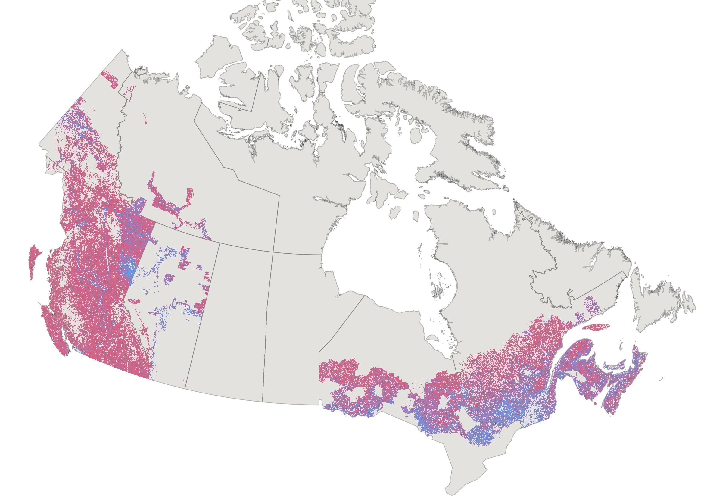
CanLaBS v2 is an update to the Canada Landsat Burned Severity (CanLaBS) data product, available at https://doi.org/10.23687/b1f61b7e-4ba6-4244-bc79-c1174f2f92cd, builds upon the methodology originally described in Guindon et al. (2021), entitled “Trends in wildfire burn severity across Canada, 1985 to 2015” and published in the Canadian Journal of Forest Research (https://doi.org/10.1139/cjfr-2020-0353). CanLaBS v2 introduces several important improvements to input data sources, temporal coverage, and modeling approaches. **1. Key Updates in CanLaBS v2** **1.1 Transition to Landsat Collection 2** All Landsat inputs used to derive burn severity metrics have been updated from Landsat Collection 1 to Landsat Collection 2 (Earth Resources Observation and Science (EROS) Center, 2020a, 2020b, 2020c). Landsat Collection 2 provides improved radiometric calibration, refined atmospheric correction, and enhanced geometric accuracy, resulting in greater temporal consistency and more reliable spectral change detection across sensors and years. **1.2. Expanded fire perimeter coverage (NBAC 1986–2024)** The updated product now covers all fire perimeters included in the National Burn Area Composite (NBAC; Skakun et al., 2022) from 1986 to 2024. This substantially extends the temporal range of the dataset relative to the original release and ensures consistency with the most up-to-date national fire perimeter record used in Canada-wide disturbance analyses. **1.3. Improved random forest model for salvage logging detection** Salvage logging detection has been updated using an improved random forest (RF) classification model trained on 3614 photo-interpreted reference points. The model uses a refined set of spectral predictors derived from Landsat imagery, including pre- and post-fire band 3, post-fire bands 4, 5 and 7 (according to the Landsat 7 nomenclature), inter-annual spectral differences (ΔB3, ΔB4, ΔB5), and pre- and post-fire Normalized Difference Vegetation Index (NDVI). Model performance was evaluated using a train-test split (80%, 20%, respectively). This analysis revealed an overall accuracy of 90.6% and Cohen’s kappa of 0.87 (See **Table 1 in the update report**, available in the download section). Some confusion occurred between low-vegetation fires and salvage logging (the primary class of interest), but overall performance was strong, with 95.49% precision, 75.6% recall, and an F1-score of 84.39%. **1.4. Revised gapfilling strategy** As in the original product, gapfilling of pre-fire Landsat data is retained to ensure complete characterization of pre-disturbance conditions. However, post-fire Landsat gapfilling is no longer applied in this version. This results in some missing data but avoids the introduction of uncertainty associated with radiometric regression-based gapfilling. A total of 6.9% of all NBAC burnt pixels are missing data. This proportion decreased over time due to improved Landsat data coverage, from 12.7% for fires before 2000 (pre-Landsat 7) to 2.59% for fires after 2012 (post-Landsat 8 launch). **1.5. Removal of pre-fire forest attribute layers** Pre-fire forest attribute layers (e.g., canopy density, live aboveground dry biomass, species composition) are no longer included in this version of CanLaBS. These attributes are now provided through the Spatialized Canadian National Forest Inventory (SCANFI v2; Guindon et al., 2026 ), which offers a more comprehensive, internally consistent, and regularly updated source of pre-disturbance forest information. Users are encouraged to combine CanLaBS with SCANFI v2 (Guindon et al., 2026) for their analyses. Users should use forest attributes from 2 years before the fire to avoid over-smoothed data that artificially underestimate pre-fire forest vegetation when pre-fire year Landsat data are unavailable. The fire start dates can be accessed via NBAC (https://cwfis.cfs.nrcan.gc.ca/datamart). **2. Use limitations** **2.1.** This database is not designed to study a single fire or a limited number of fires but rather to study large areas with several fires. No radiometric correction or change was made per fire such as the offset method, or a mean, or median approach for pixels of the same year (see cjfr-2020-0353supplb at https://doi.org/10.1139/cjfr-2020-0353). Even if surface reflectance images were used, there may be radiometric differences within the same fire due to the use of different Landsat scenes. Differences in atmospheric correction between adjacent scenes may therefore be perceptible. The primary reason for not applying additional corrections in these cases is the insufficient number of pixels available per fire during July and August, particularly in certain regions and specific time periods.To achieve a spatially and temporally consistent database, a uniform processing approach was applied to all pixels. These points are discussed in the article and in the supplementary material (see cjfr-2020-0353supplb at https://doi.org/10.1139/cjfr-2020-0353). **2.2.** Burnt areas that have undergone salvage logging were detected using a classification approach. This is not an exhaustive mapping of all areas that were salvage logged beyond one year after the fire, the goal was to eliminate these areas from the analyses, as the post-fire values (NBRpost) would be biased by the absence of trees and by the presence of soil disturbed by scarification. **2.3.** Fires occurring in forests heavily affected by the mountain pine beetle (Dendroctonus ponderosae), spruce budworm (Choristoneura fumiferana), or other defoliators should ideally be excluded from analyses, as pre-fire NBR values are inherently low, potentially biasing dNBR-based assessments. CanLaD (Perbet et al., 2025) now provides identification of these affected areas (available at https://doi.org/10.23687/902801fd-4d9d-4df4-9e95-319e429545cc). **2.4.** The 1985 and 2024 fires represent the beginning and end years of the time series, it is possible that some fires are incomplete for these years, and perhaps to a lesser extent for the 1986 and 2023 fires. **3. Summary** Overall, this update improves the precision and temporal coverage of the CanLaBS data product by leveraging Landsat Collection 2 with updated national fire perimeter polygons and a refined salvage detection method. These changes enhance the suitability of the dataset for national-scale analyses of fire effects, post-fire management, and long-term disturbance dynamics in Canadian forests. **4. Layers description** There are 3 layers: - CanLaBS_1985_2024_v20260121.tif - dNBR values for all burnt pixels according to NBAC - CanLaBS_salvageMask_1985_2024_v20260121.tif - Binary layer where '1' identifies pixels where salvage logging occurred - NBAC_MRB_1972to2024_reproj.tif - NBAC fire year **5. Data download** The data can be downloaded from the FTP server (ftp.maps.canada.ca/pub/nrcan_rncan/Forest-fires_Incendie-de-foret/CanLaBS_v2-Burned_Severity-Severite_des_feux), referenced in the “Data and Resources” section, using a browser download manager, such as DownThemAll, or an external client such as FileZilla. **6. Dataset citation** - Guindon L., Correia D., Perbet P. 2026. Canada Landsat Burned Severity (CanLaBS v2): a Canada-wide Landsat-based 30-m resolution product of burned severity since 1985. https:/doi.org/10.23687/2af751e7-79f9-4da8-9b45-14688818dca3 **7. References** - Earth Resources Observation and Science (EROS) Center. 2020a. Landsat 4–5 Thematic Mapper Level-2, Collection 2. Dataset. U.S. Geological Survey. https://doi.org/10.5066/P9IAXOVV - Earth Resources Observation and Science (EROS) Center. 2020b. Landsat 7 Enhanced Thematic Mapper Plus Level-2, Collection 2. Dataset. U.S. Geological Survey. https://doi.org/10.5066/P9C7I13B - Earth Resources Observation and Science (EROS) Center. 2020c. Landsat 8–9 Operational Land Imager / Thermal Infrared Sensor Level-2, Collection 2. Dataset. U.S. Geological Survey. https://doi.org/10.5066/P9OGBGM6 - Guindon, L., S. Gauthier, F. Manka, M. A. Parisien, E. Whitman, P. Bernier, A. Beaudoin, P. Villemaire, and R. Skakun. 2021. “Trends in Wildfire Burn Severity across Canada, 1985 to 2015.” Canadian Journal of Forest Research 51 (9): 1230–1244. https://doi.org/10.1139/cjfr-2020-0353 - Guindon, L., P. Villemaire, D. L. P. Correia, F. Manka, S. Lacarte, and B. Smiley. 2023. SCANFI: Spatialized CAnadian National Forest Inventory Data Product. Natural Resources Canada, Canadian Forest Service, Laurentian Forestry Centre, Quebec, Canada. https://doi.org/10.23687/18e6a919-53fd-41ce-b4e2-44a9707c52dc - Guindon, L., D. L. P. Correia, F. Manka, and B. Smiley. 2026. SCANFI v2: Spatialized Canadian National Forest Inventory Data Product. Quebec, Canada: Natural Resources Canada, Canadian Forest Service, Laurentian Forestry Centre. https://doi.org/10.23687/07653869-f303-46c2-a04e-9ab479b73cbf - Perbet, P., L. Guindon, D. L. P. Correia, et al. 2025. “Historical Insect Disturbance Maps from 1985 Onwards for Canadian Forests Derived Using Earth Observation Data.” Scientific Data 12: 2012. https://doi.org/10.1038/s41597-025-06269-x - Perbet, P., L. Guindon, D. L. P. Correia, P. Villemaire, O. Reisi Gahrouei, and R. St-Amant. Canada Landsat Disturbance with Pest (CanLaD): A Canada-Wide Landsat-Based 30-m Resolution Product of Fire, Harvest and Pest Outbreak Detection and Attribution since 1987. https://doi.org/10.23687/902801fd-4d9d-4df4-9e95-319e429545cc - Skakun, R., G. Castilla, J. Metsaranta, E. Whitman, S. Rodrigue, J. Little, K. Groenewegen, and M. Coyle. 2022. “Extending the National Burned Area Composite Time Series of Wildfires in Canada.” Remote Sensing 14 (13): 3050.
-
Deforestation in Canada is estimated with the National Deforestation Monitoring System (NDMS). Details describing this process are published here: https://cfs.nrcan.gc.ca/publications?id=36042. Deforestation is the direct human-induced conversion of forested land to non-forested land use. Canada’s National Deforestation Monitoring System (NDMS) was designed and implemented to provide information needed by Canada to meet its obligation under the United Nations Framework Convention on Climate Change (UNFCCC) to report the areas affected annually by deforestation. It also provides important information for the public, government policy makers, and scientists. To provide information about the amount of deforestation and why, where, and when it occurred in Canada, the NDMS uses deforestation mapped on a system of sample areas. The mapping is based on visual interpretation of satellite imagery supported by available ancillary information, such as high resolution imagery, forest inventory, and industrial databases, and informed by records-based information and expert knowledge. Accurate detection and mapping of deforestation events involves manual interpretation of satellite remote sensing imagery by specialized analysts. A key factor in the mapping is to distinguish deforestation from other forest cover losses that occur in Canada. The NDMS was designed to make use of all available lines of evidence and be flexible to accommodate variable resourcing levels. This system has been producing national deforestation monitoring results annually since 2006. The flexibility of the NDMS’s design makes it possible to adapt to future changes in data and resource availability, and positions the program well for sustained operational delivery into the future.