 Arctic SDI catalogue
Integrated management
Type of resources
Topics
Keywords
Contact for the resource
Provided by
Formats
Representation types
Update frequencies
status
-

The spatial planning framework for Canada's national network of Marine Protected Areas (MPAs) is comprised of 13 ecologically defined bioregions that cover Canada's oceans and the Great Lakes. Note that the geographic boundaries for the bioregions are fuzzy and may change based on ecosystemic conditions. Detailed descriptions and discussions on the federal network of marine bioregions can be found in: - DFO. 2009. Development of a Framework and Principles for the Biogeographic Classification of Canadian Marine Areas. DFO Can. Sci. Advis. Sec. Sci. Advis. Rep. 2009/056 (http://www.dfo-mpo.gc.ca/csas-sccs/publications/sar-as/2009/2009_056-eng.htm); - DFO. 2010. Proceedings of a National Science Advisory Process to Provide Guidance on the Development of a Framework and Principles for the Biogeographic Classification of Canadian Marine Areas; 15-16 June 2009. DFO Can. Sci. Advis. Sec. Proceed. Ser. 2009/039. (http://www.dfo-mpo.gc.ca/csas-sccs/publications/pro-cr/2009/2009_039-eng.htm); and - National Framework for Canada's Network of Marine Protected Areas (http://www.dfo-mpo.gc.ca/oceans/publications/mpanf-cnzpm/page01-eng.html).
-
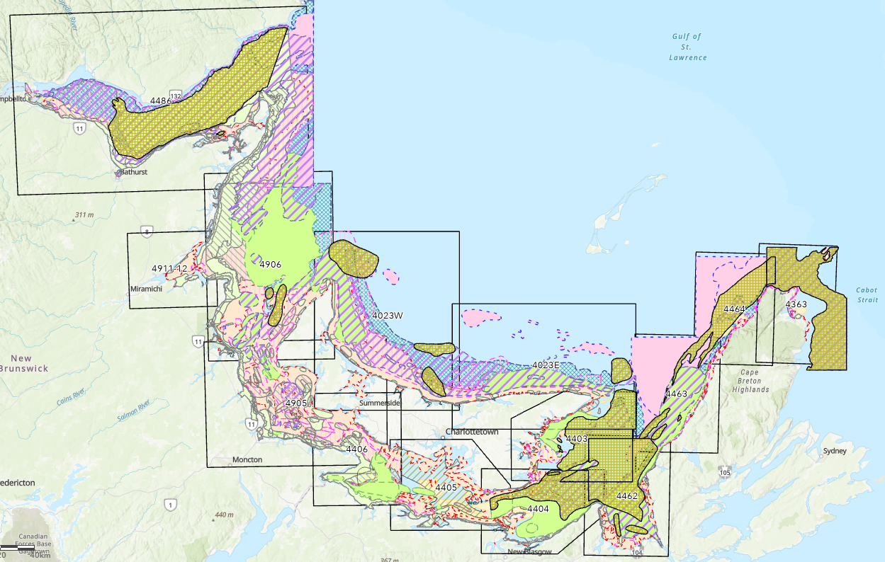
In 1998, Fisheries and Oceans Canada (DFO) published an atlas called "Traditional Fisheries Knowledge for the Southern Gulf of St. Lawrence". The document is composed of a series of maps that contain useful information primarily on nearshore fisheries and fish habitat in the eastern shore of New Brunswick, Prince Edward Island and the Gulf Shore of Nova Scotia. It was used as a working tool to assist in the development of integrated coastal zone management plans, resource management plans, and more. Between 1994 and 1997, data collectors and fishery officers interviewed local fishers and industry representatives. The purpose of these interviews was primarily to gain information on local fishing activities and the location of fisheries' resources and their habitats. The data and information was vetted through a process of verification with scientists, fishers, locals, industry representatives, and government officials. Maps were then compiled for 14 commercially important fish species and made publicly available to consult. These include lobster, rock crab, scallop, snow crab, toad crab, herring, mackerel, American plaice, cod, witch flounder (grey sole), hake, halibut, winter flounder, and unspecified groundfish. This data resource also includes the other 27 species originally not included in the atlas.
-

Fisheries and Oceans Canada (DFO) has worked with partners and ocean users to develop a draft conservation network plan for the Scotian Shelf-Bay of Fundy Bioregion. This work led to the 2017 draft conservation network plan. The draft plan was updated after targeted consultations from 2021 to 2022. The latest draft reflects new science information on climate change, updated human-use activities (such as fisheries data), and feedback from consultations. This dataset includes the latest existing and proposed conservation sites in the Scotian Shelf-Bay of Fundy Bioregion. Existing sites: -Marine Protected Areas (MPAs) -Marine refuges -Migratory bird sanctuary, National Wildlife area and National Park with marine components Proposed sites: -Areas of Interest (AOIs) and their lead agency -Tier 1 sites – higher priority for implementation and are among the sites that could be selected for advancement by 2030. These sites have high conservation value based on the confirmed presence of key ecological features. The lead federal agency is specified for all tier 1 sites. -Tier 2 sites - are important to create a representative conservation network but will not be considered for advancement by 2030. These sites require more research and information on ecological features and human uses before implementation. -Other sites have also been identified through network planning. These are not considered part of the conservation network plan at this time. Proposed conservation sites: 1. Cobequid Bay 2. Southern Bight 3. Chignecto Bay 4. Salmon Rivers 5. Bay of Fundy Horse Mussel Aggregations 6. West Isles and Passages 7. Long Eddy 8. South Grand Manan 9. Brier Island 10. Chebogue 11. Eel Bay 12. McNutts Island 13. Pemsɨk 14. LaHave Islands 15. Sambro Ledges-Prospect 16. Martinique Beach and Musquodoboit Harbour 17. St. Mary’s (Napu’saqnuk) River and Estuary 18. Country Island 19. MacNamaras Island 20. Canso Ledges-Sugar Harbour Islands 21. Fleur-de-Lis Coast 22. Bird Islands 23. Ingonish 24. Aspy Bay 25. Bras d’Or Lake 26. Southwest Bank 27. Western Jordan Basin 28. Georges Bank 29. LaHave Basin 30. Scotian Gulf 31. Central Scotian Slope, Rise, and Abyss 32. Inner Shelf Sea Pen Field 33. Sable Island Bank 34. Logan Canyon 35. Canso Bank and Channels 36. Misaine Bank and Laurentian Channel 37. Eastern Shoal 38. Cold Seeps Boundaries are preliminary and subject to change following public consultation.