 Arctic SDI catalogue
Kelp
Type of resources
Topics
Keywords
Contact for the resource
Provided by
Formats
Representation types
Update frequencies
status
-

Coastal vegetated ecosystems are recognized for their role in cycling and storing carbon in the world’s oceans (i.e., blue carbon); however, high uncertainty in carbon sequestration rates is partly due to an absence of studies estimating carbon export to the deep sea. We modeled export from nearshore kelp forests and seagrass beds, showing variability by orders of magnitude across spatial scales (3 to hundreds of kilometers), kelp and seagrass species, seasons, and carbon forms, raising caution in using generalized export rates in blue carbon accounting. Our results also show rapid (20 to 30 days) and extensive export of neutrally buoyant dissolved organic carbon particles to the shelf break (up to 44% within 90 days), contrasting sinking particulate organic carbon particles that largely remained within 100-meter water depth in the nearshore. These results improve estimates of carbon sequestration by blue carbon ecosystems and reveal contrasting patterns of export relative to other regions of the globe. Cite this data as: Kira A. Krumhansl et al., Pathways of blue carbon export from kelp and seagrass beds along the Atlantic coast of Nova Scotia.Sci. Adv.11,eadw1952(2025).DOI: 10.1126/sciadv.adw1952
-
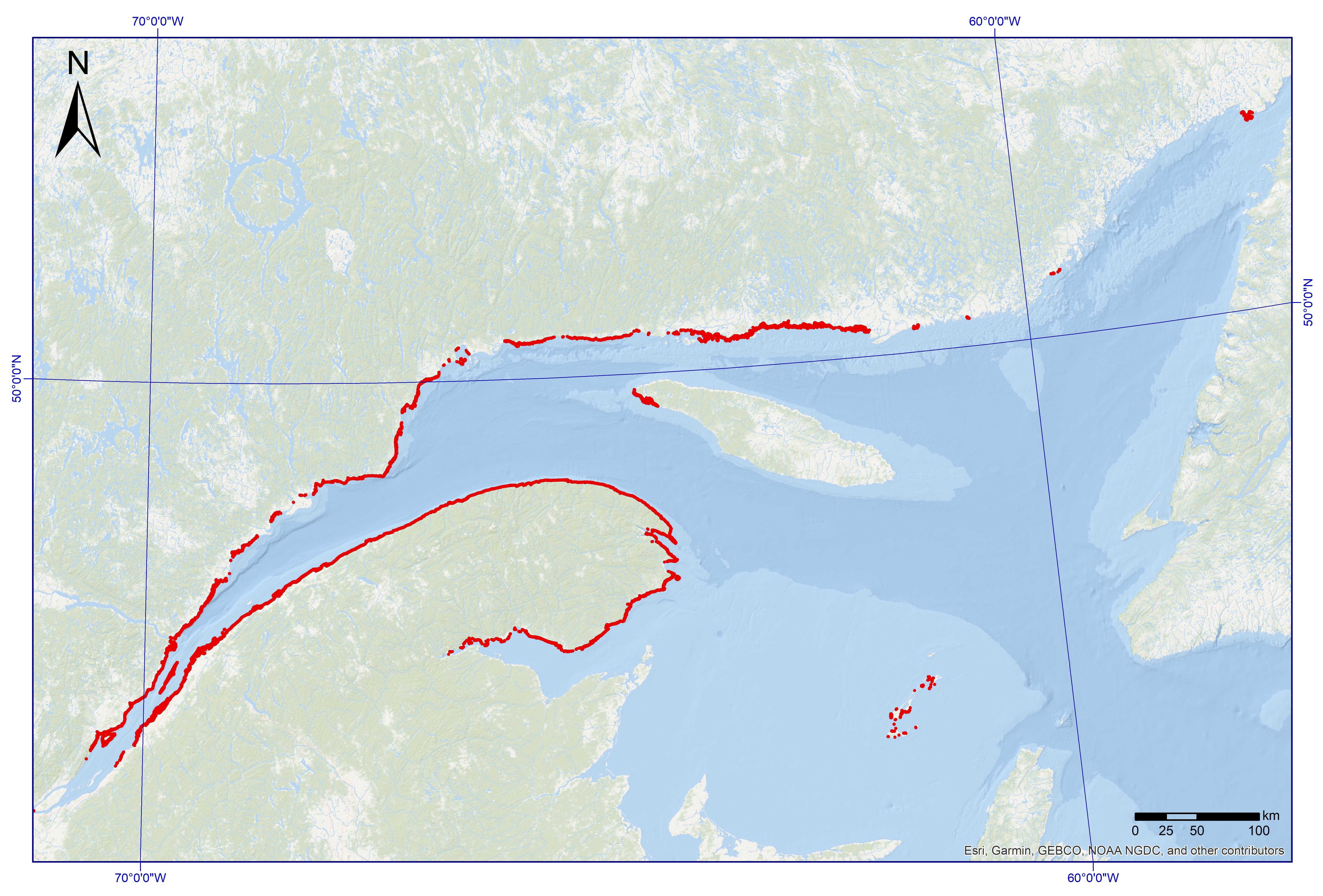
Macroalgae dominated areas with a vegetated cover above 25%, located in the coastal zone of the Estuary and the Gulf of St. Lawrence (Quebec) This dataset was designed for Environment and Climate Change Canada's (ECCC) National Environmental Emergencies Center (NEEC) for oil spill preparedness and response. The polygons of this layer were selected from the surface geodatabase of coastal ecosystems from the UQAR-MPO project Mapping coastal ecosystems of the Estuary and Gulf of St. Lawrence. Are represented in this dataset exclusively the polygons whose plant dominance corresponds to a class of macroalgae and presenting a semi-vegetated (25-75%) or vegetated (75-100%) cover. The study area includes all of the estuarine and maritime coasts of Quebec, with the exception of certain sectors, including most of the Lower North Shore and Anticosti Island, with the exception of villages of Kegaska, la Romaine, Chevery, Blanc-Sablon and Port-Menier. Some islands off the estuary and gulf coasts are part of the region covered, such as Île d'Orléans, Isle-aux-Coudres, Île Verte and Île Bonaventure. The mapping of coastal ecosystems was carried out jointly by the Laboratory for Dynamics and Integrated Coastal Zone Management (LDGIZC) of the University of Quebec at Rimouski as part of the Coastal Resilience Project (https: //ldgizc.uqar.ca/Web/projets/projet-resilience-cotiere) funded by the MELCC; and by the Fisheries and Oceans Canada team, as part of its Integrated marine response planning (IMRP) component of the Oceans Protection Plan (OPP),with the objective of updating the Marine Oil Spill Preparedness and Response Regime of Canada. The master geodatabase of coastal ecosystems is hosted and distributed by UQAR on their SIGEC-Web mapping platform: https://ldgizc.uqar.ca/Web/sigecweb The macroalgae characterization was mainly carried out from the photo-interpretation of RGBI aerial photos acquired by the DFO (2015-2022) and oblique helicopter photos acquired by UQAR in 2017. Data from 3155 sampling stations, conducted aboard small boats during DFO field campaigns (2017-2023) were used to detail the nature of algal communities and validate the photo-interpretation. Credits © UQAR-MPO (2025, Laboratoire de dynamique et de gestion intégrée des zones côtières, Pêches et Océans Canada) Référence Provencher-Nolet, L., Paquette, L., Pitre, L.D., Grégoire, B. and Desjardins, C. 2024. Cartographie des macrophytes estuariens et marins du Québec. Rapp. Tech. Can. Sci. halieut. Aquat. 0000 : v + 99 p. Grégoire, B., Pitre, L.D., Provencher-Nolet, L., Paquette, L. and Desjardins, C. 2024. Distribution d’organismes marins de la zone côtière peu profonde du Québec recensés par imagerie sous-marine de 2017 à 2021. Rapp. tech. can. sci. halieut. aquat. 0000 : v + 78 p. Grégoire, B. 2022. Biodiversité du relevé côtier Planification pour une intervention environnementale intégrée dans l’estuaire et le golfe du Saint-Laurent (2017–2021). Observatoire global du Saint-Laurent. [Jeu de données] Jobin, A., Marquis, G., Provencher-Nolet, L., Gabaj Castrillo. M. J., Trubiano C., Drouet, M., Eustache-Létourneau, D., Drejza, S. Fraser, C. Marie, G. et P. Bernatchez (2021) Cartographie des écosystèmes côtiers du Québec maritime — Rapport méthodologique. Chaire de recherche en géoscience côtière, Laboratoire de dynamique et de gestion intégrée des zones côtières, Université du Québec à Rimouski. Rapport remis au ministère de l’Environnement et de la Lutte contre les changements climatiques, septembre 2021, 98 p.
-
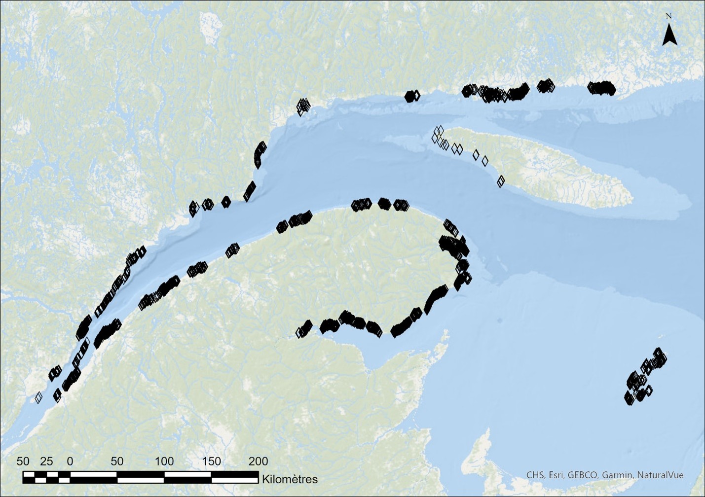
Between 2017 and 2024, underwater imaging sampling campaigns were conducted by Fisheries and Oceans Canada across a broad area of the shallow coastal zone of the St. Lawrence Estuary and Gulf. The sampling targeted the lower intertidal and subtidal zones, to a maximum depth of approximately 10 m, with an emphasis on eelgrass beds and macroalgae. These targeted surveys were primarily intended to produce ground-truth data for the mapping of estuarine and marine macrophytes of the Québec maritime region (Provencher-Nolet et al., 2025), supporting oil spill preparedness and response activities. This dataset summarizes information generated from the analysis of underwater video footage collected at 3,179 sampling stations using small boats equipped with a pole-mounted camera system, as described in Grégoire et al. (2025). The dataset documents multiple characteristics of coastal ecosystems, including the cover of erect vegetation, vegetation assemblages, dominant and minor vegetation, substrates, fauna, as well as the presence of encrusting algae, for each sampling station. The different attributes recorded during video analysis, along with certain identification criteria, are presented in the visual dictionary of Grégoire et al. (2022).