Labrador
Type of resources
Available actions
Topics
Keywords
Contact for the resource
Provided by
Years
Formats
Representation types
Update frequencies
status
Service types
-
Environment Canada and the provincial Department of Environment and Conservation have been monitoring ambient surface water quality of selected water bodies in the province since 1986 under the Canada-Newfoundland Water Quality Monitoring Agreement (WQMA). The purpose of this Agreement was practical coordination and integration of federal and provincial water quality monitoring activities. On April 29, 1986, an Agreement was signed between the federal and provincial government to establish a joint water quality monitoring network. The WQMA provides for the regular monitoring of an index network of stations, as well as an annual recurrent study concentrating on water quality, sediment and biota in a selected watershed. Since its inception, the Agreement has seen water quality data collected at a total of 111 monitoring sites.
-

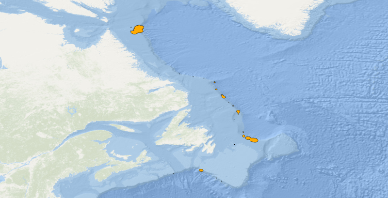
Polygons denoting concentrations of sea pens, small and large gorgonian corals and sponges on the east coast of Canada have been identified through spatial analysis of research vessel survey by-catch data following an approach used by the Northwest Atlantic Fisheries Organization (NAFO) in the Regulatory Area (NRA) on Flemish Cap and southeast Grand Banks. Kernel density analysis was used to identify high concentrations and the area occupied by successive catch weight thresholds was used to identify aggregations. These analyses were performed for each of the five biogeographic zones of eastern Canada. The largest sea pen fields were found in the Laurentian Channel as it cuts through the Gulf of St. Lawrence, while large gorgonian coral forests were found in the Eastern Arctic and on the northern Labrador continental slope. Large ball-shaped Geodia spp. sponges were located along the continental slopes north of the Grand Banks, while on the Scotian Shelf a unique population of the large barrel-shaped sponge Vazella pourtalesi was identified. The latitude and longitude marking the positions of all tows which form these and other dense aggregations are provided along with the positions of all tows which captured black coral, a non-aggregating taxon which is long-lived and vulnerable to fishing pressures. These polygons identify sponge grounds from the broader distribution of sponges in the region as sampled by Campelen trawl gear in the Newfoundland - Labrador Shelves biogeographic zone. A 200 kg minimum threshold for the sponge catch was identified as the weight that separated the sponge ground habitat from the broader distribution of sponges with these research vessel tow data and gear type.
-

Polygons denoting concentrations of sea pens, small and large gorgonian corals and sponges on the east coast of Canada have been identified through spatial analysis of research vessel survey by-catch data following an approach used by the Northwest Atlantic Fisheries Organization (NAFO) in the Regulatory Area (NRA) on Flemish Cap and southeast Grand Banks. Kernel density analysis was used to identify high concentrations and the area occupied by successive catch weight thresholds was used to identify aggregations. These analyses were performed for each of the five biogeographic zones of eastern Canada. The largest sea pen fields were found in the Laurentian Channel as it cuts through the Gulf of St. Lawrence, while large gorgonian coral forests were found in the Eastern Arctic and on the northern Labrador continental slope. Large ball-shaped Geodia spp. sponges were located along the continental slopes north of the Grand Banks, while on the Scotian Shelf a unique population of the large barrel-shaped sponge Vazella pourtalesi was identified. The latitude and longitude marking the positions of all tows which form these and other dense aggregations are provided along with the positions of all tows which captured black coral, a non-aggregating taxon which is long-lived and vulnerable to fishing pressures. These polygons identify small gorgonian coral fields from the broader distribution of small gorgonian corals in the region as sampled by Campelen trawl gear in the Newfoundland - Labrador Shelves biogeographic zone. A 0.3 kg minimum threshold for the small gorgonian coral catch was identified as the weight that separated the small gorgonian field habitat from the broader distribution of small gorgonian corals with these research vessel tow data and gear type.
-

Polygons denoting concentrations of sea pens, small and large gorgonian corals and sponges on the east coast of Canada have been identified through spatial analysis of research vessel survey by-catch data following an approach used by the Northwest Atlantic Fisheries Organization (NAFO) in the Regulatory Area (NRA) on Flemish Cap and southeast Grand Banks. Kernel density analysis was used to identify high concentrations and the area occupied by successive catch weight thresholds was used to identify aggregations. These analyses were performed for each of the five biogeographic zones of eastern Canada. The largest sea pen fields were found in the Laurentian Channel as it cuts through the Gulf of St. Lawrence, while large gorgonian coral forests were found in the Eastern Arctic and on the northern Labrador continental slope. Large ball-shaped Geodia spp. sponges were located along the continental slopes north of the Grand Banks, while on the Scotian Shelf a unique population of the large barrel-shaped sponge Vazella pourtalesi was identified. The latitude and longitude marking the positions of all tows which form these and other dense aggregations are provided along with the positions of all tows which captured black coral, a non-aggregating taxon which is long-lived and vulnerable to fishing pressures. These polygons identify large gorgonian coral fields from the broader distribution of large gorgonian corals in the region as sampled by Campelen trawl gear in the Newfoundland - Labrador Shelves biogeographic zone. A 0.3 kg minimum threshold for the large gorgonian coral catch was identified as the weight that separated the large gorgonian field habitat from the broader distribution of large gorgonian corals with these research vessel tow data and gear type.
-

Polygons denoting concentrations of sea pens, small and large gorgonian corals and sponges on the east coast of Canada have been identified through spatial analysis of research vessel survey by-catch data following an approach used by the Northwest Atlantic Fisheries Organization (NAFO) in the Regulatory Area (NRA) on Flemish Cap and southeast Grand Banks. Kernel density analysis was used to identify high concentrations and the area occupied by successive catch weight thresholds was used to identify aggregations. These analyses were performed for each of the five biogeographic zones of eastern Canada. The largest sea pen fields were found in the Laurentian Channel as it cuts through the Gulf of St. Lawrence, while large gorgonian coral forests were found in the Eastern Arctic and on the northern Labrador continental slope. Large ball-shaped Geodia spp. sponges were located along the continental slopes north of the Grand Banks, while on the Scotian Shelf a unique population of the large barrel-shaped sponge Vazella pourtalesi was identified. The latitude and longitude marking the positions of all tows which form these and other dense aggregations are provided along with the positions of all tows which captured black coral, a non-aggregating taxon which is long-lived and vulnerable to fishing pressures. These polygons identify sea pen fields from the broader distribution of sea pens in the region as sampled by Campelen trawl gear in the Newfoundland - Labrador Shelves biogeographic zone. A 0.4 kg minimum threshold for the sea pen catch was identified as the weight that separated the sea pen field habitat from the broader distribution of sea pens with these research vessel tow data and gear type.
-
The Innu Audio Index is an extract from the Canadian Geographical Names Data Base (CGNDB) of geographical names with associated audio. The shared audio with the Geographical Names Board of Canada (GNBC) is the intellectual property of the Innu Nation. The points represent official geographical names in Innu-aimun, the language of the Innu Nation. The CGNDB is the authoritative national database of Canada's geographical names. It contains geographical names and their attributes that have been approved by the GNBC, the national coordinating body responsible for standards and policies on place names. The GNBC is working to increase awareness of existing Indigenous place names and help promote the revitalization of Indigenous cultures and languages. The GNBC does not warrant or guarantee that the information is accurate, complete or current at all times. For more information, to report data errors, or to suggest improvements, please contact the GNBC Secretariat at Natural Resources Canada with questions or for more information.
-

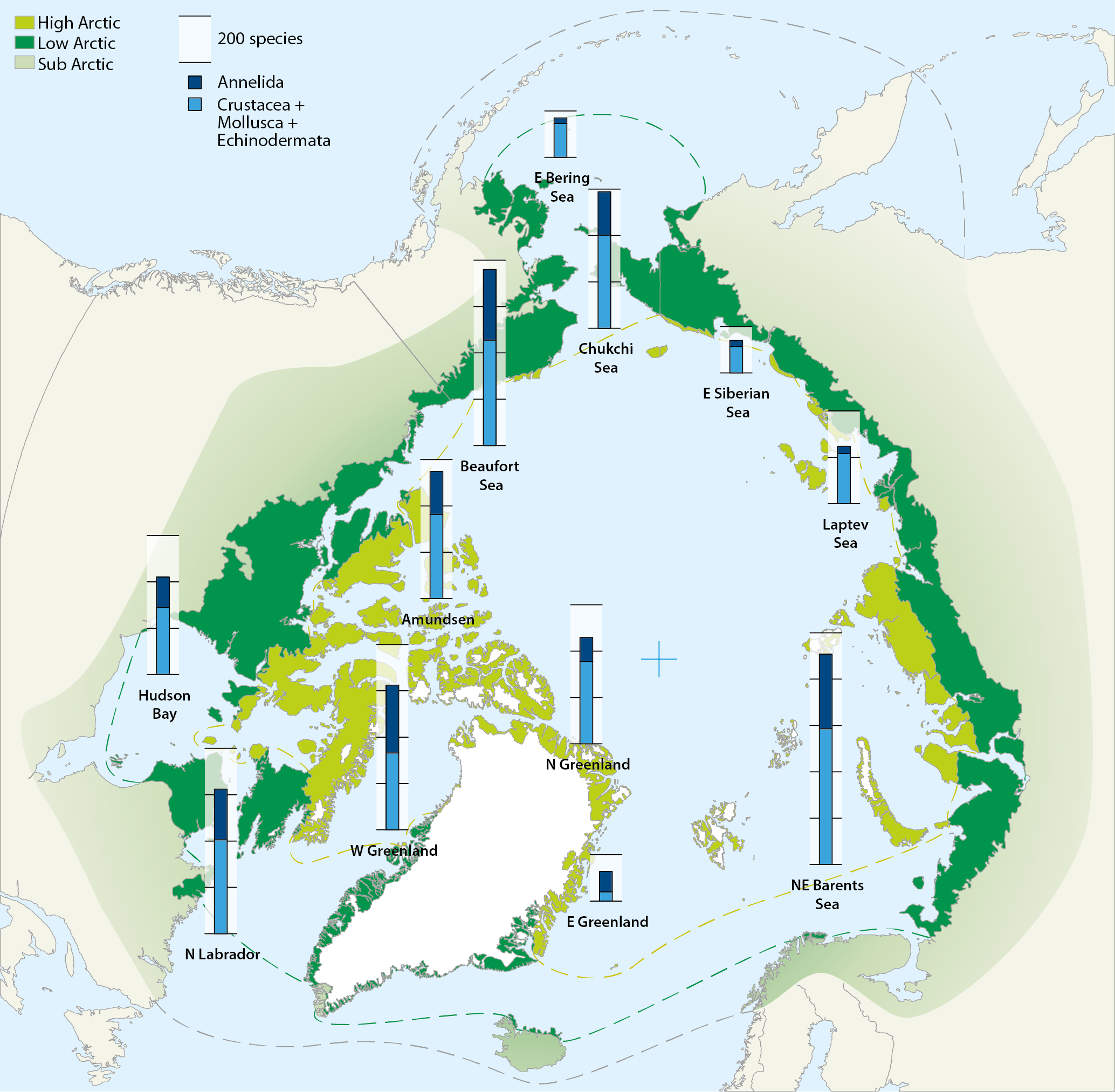
Map of the Arctic Ocean with superimposed stacked bars representing species numbers of macrozoobenthos from different shelf sea areas: Crustacea+Mollusca+Echinodermata (blue) and Annelida (black). Compiled by Piepenburg et al. (2011). Conservation of Arctic Flora and Fauna, CAFF 2013 - Akureyri . Arctic Biodiversity Assessment. Status and Trends in Arctic biodiversity. - Marine Invertebrates(Chapter 8) page 282
 Arctic SDI catalogue