benthic
Type of resources
Available actions
Topics
Keywords
Contact for the resource
Provided by
Years
Formats
Representation types
Update frequencies
status
Service types
-
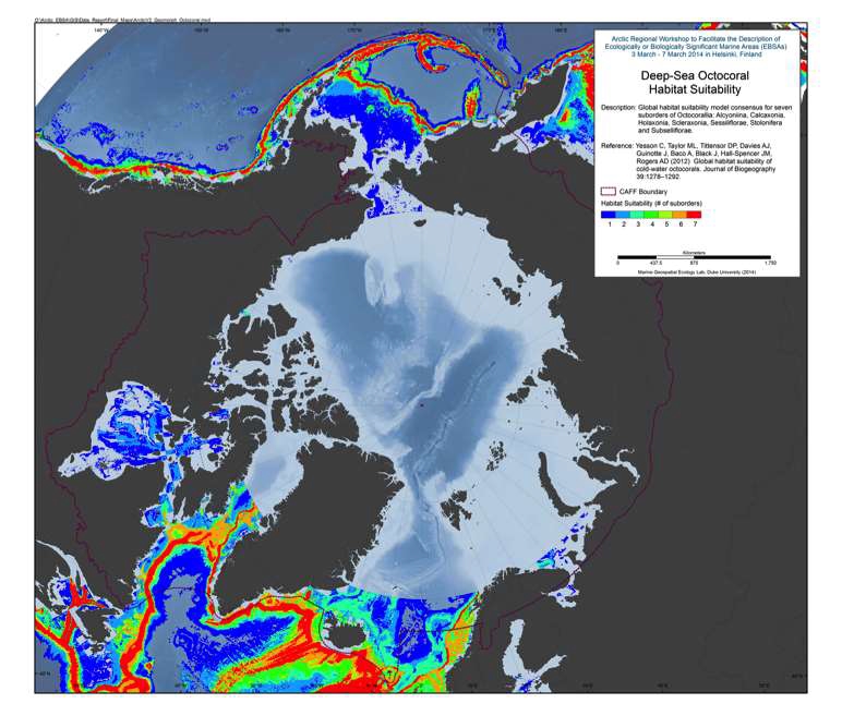
Three-quarters of Octocorallia species are found in deep waters. These cold- water octocoral colonies can form a major constituent of structurally complex habitats. The global distribution and the habitat requirements of deep-sea octocorals are poorly understood given the expense and difficulties of sampling at depth. Habitat suitability models are useful tools to extrapolate distributions and provide an understanding of ecological requirements. Here, we present global habitat suitability models and distribution maps for seven suborders of Octocorallia: Alcyoniina, Calcaxonia, Holaxonia, Scleraxonia, Sessiliflorae, Stolonifera and Subselliflorae. Reference: Yesson C, Taylor ML, Tittensor DP, Davies AJ, Guinotte J, Baco A, Black J, Hall-Spencer JM, Rogers AD (2012) Global habitat suitability of cold-water octocorals. Journal of Biogeography 39:1278–1292.
-
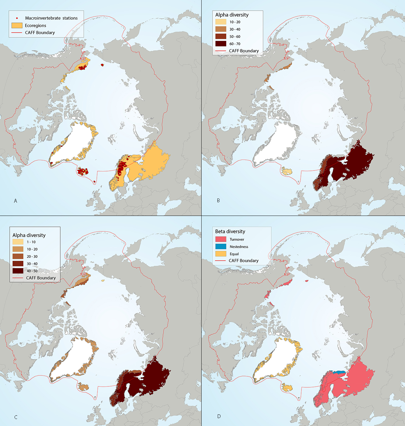
Results of circumpolar assessment of lake littoral benthic macroinvertebrates, indicating (a) the location of littoral benthic macroinvertebrate stations, underlain by circumpolar ecoregions; (b) ecoregions with many littoral benthic macroinvertebrate stations, colored on the basis of alpha diversity rarefied to 80 stations; (c) all ecoregions with littoral benthic macroinvertebrate stations, colored on the basis of alpha diversity rarefied to 10 stations; (d) ecoregions with at least two stations in a hydrobasin, colored on the basis of the dominant component of beta diversity (species turnover, nestedness, approximately equal contribution, or no diversity) when averaged across hydrobasins in each ecoregion. State of the Arctic Freshwater Biodiversity Report - Chapter 4 - Page 65 - Figure 4-29
-
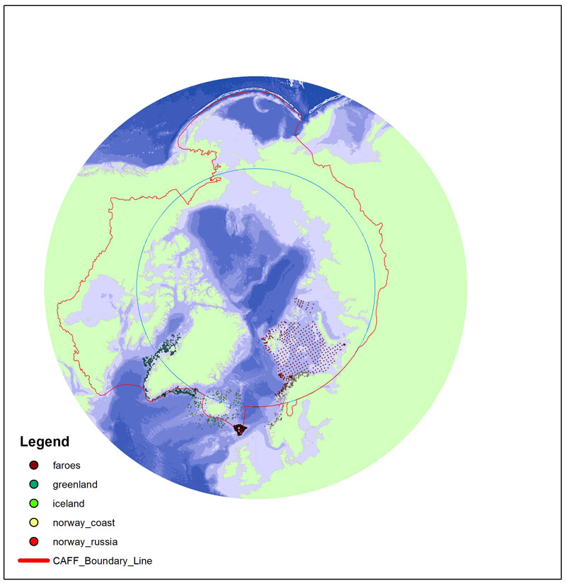
Long-term monitoring programs on benthic fauna are missing for large areas of the Arctic. In areas where repeated monitoring has occurred, it is difficult to compare data due to different sampling approaches and different targets of monitoring efforts. There is a need for an international standardization of long- term benthic monitoring. The CBMP Benthos Expert Network has identified potential ways to improve benthic monitoring coverage, and has come up with a map showing a Pan Arctic station map.
-
(La version française suit) What is an Ecologically and Biologically Significant Area? Ecologically and Biologically Significant Areas (EBSAs) are areas within Canada’s oceansthat have been identified through formal scientific assessments as having special biological or ecological significance when compared with the surrounding marine ecosystem.Failure to define an area as an EBSA does not mean that it is unimportant ecologically. All areas serve ecological functions to some extent and require sustainable management. Rather, areas identified as EBSAs should be viewed as the most important areas where, with existing knowledge, regulators and marine users should be particularly risk averse to ensure ecosystems remain healthy and productive. Why are EBSAs identified? EBSA information is used to inform marine planning, including environmental assessment and the siting of marine-based activities, by: Informing and guiding project-specific or regional environmental assessments; Informing and guiding industries and regulators in their planning and operations, for example: EBSAs have been acknowledged and referred to (often as "Special Areas" or "Potentially Sensitive Areas") in oil and gas related assessments. EBSA information has been provided to proponents of submarine cable projects to be used for route planning purposes. Informing and guiding the Integrated Oceans Management (IOM)process within five Large Oceans Management Areas (LOMAs)and 12 marine bioregions; Serving as a basis for the identification of Areas of Interest (AOIs)and of Marine Protected Areas (MPAs)(individually and in the context of planning bioregional networks of MPAs); How are EBSAs identified? The process used to identify EBSAs is generally comprised of two phases. The first phase involves compiling scientific data and knowledge of a marine area’s ecosystems ─ notably fish species, marine mammals, sea birds, marine flora, marine productivity, physical and chemical conditions and geology. “Knowledge” includes experiential knowledge of long-time uses of the areas. In some cases (e.g., in the Arctic), substantial efforts are taken to collect traditional knowledge on ecosystems and environmental conditions from community members, fish harvests, hunters and individuals whose knowledge of the study area complement and often helps fill scientific data gaps. In the second phase, the available information for a marine area (e.g. a bioregion) is assessed against five nationally-established science-based criteria including: Uniqueness: How distinct is the ecosystem of an area compared to surrounding ones? Aggregation: Whether or not species populate or convene to the study area? Fitness consequence: How critical the area is to the life history of the species that use it (e.g. is it a spawning or feeding ground)? Naturalness: How pristine or disturbed by human activities is the study area? Resilience: What is the ability of the ecosystem to bounce back if it is disturbed? Progress to date and next steps EBSAs have been identified for large portions of Canada’s Atlantic and Pacific oceans as well as most of the Arctic oceans. For a map of current EBSAs in these areas, click here. EBSAs will continue to be identified in priority areas as resources become available to carry out the process. The boundaries or locations of existing EBSAs may be modified to reflect both new knowledge and changing environmental conditions. Les zones d'importance écologique et biologique (ZIEB) sont des zones au sein des eaux océaniques canadiennesque des évaluations scientifiques officielles ont désignées comme ayant une importance écologique et biologique particulière par rapport à l'écosystème marin environnant. Le fait qu'une zone n'ait pas été désignée comme ayant une importance écologique et biologique ne signifie pas pour autant qu'elle n'a pas une importance écologique. Toutes les zones assument des fonctions écologiques dans une certaine mesure et exigent une gestion durable. Les zones désignées comme des ZIEB devraient plutôt être vues comme des zones extrêmement importantes, où les connaissances, les législateurs et les utilisateurs des ressources marines doivent exercer une grande prudence eu égard au risque, afin de veiller à ce que les écosystèmes restent sains et productifs. Pourquoi des ZIEB sont-elles désignées? Les renseignements relatifs à ces aires sont utilisés pour appuyer la planification marine, notamment l'évaluation environnementale et la mise en place d'activités marines: En informant et guidant les industries et les législateurs pour une planification et une conduite d'activités optimale, par exemple: les zones d'importance écologique et biologique ont été prises en compte et mentionnées dans les évaluations portant sur le pétrole et le gaz. Des renseignements ont été fournis aux promoteurs de projets de câbles sous-marins, afin de les aider à en déterminer les tracés. En information et en guidant le processus de gestion intégrée des océans dans cinq zones étendues de gestion des océans et 12 biorégions marines. En servant de fondement pour la détermination des zones d'intérêt et des zones de protection marines (de manière individuelle et dans le cadre de la planification des réseaux biorégionaux de zones de protection marines). Comment désigne-t-on les zones d'importance écologique et biologique? Le processus utilisé pour désigner les zones d'importance écologique et biologique comprend généralement deux étapes. La première étape consiste à recueillir des données scientifiques et des connaissances relatives aux écosystèmes d'une aire marine, notamment les espèces de poissons, de mammifères marins et d'oiseaux marins, la flore marine, la productivité marine, les conditions physiques et chimiques, et la géologie. Les « connaissances » comprennent les connaissances empiriques des utilisateurs de longue date de ces aires. Dans certains cas (p. ex. dans l'Arctique), d'importants efforts sont déployés pour réunir les connaissances traditionnelles sur les écosystèmes et les conditions environnementales des membres des communautés, des pêcheurs, des chasseurs et des personnes dont la connaissance de la zone étudiée complète l'information existante et permet souvent d'aider à combler les lacunes dans les données scientifiques. La deuxième étape consiste à évaluer l'information disponible relative à une aire marine (p. ex., une biorégion) en utilisant cinq critères scientifiques nationaux: La spécificité: dans quelle mesure l'écosystème d'une aire est-il distinct des écosystèmes environnants? La concentration: l'aire étudiée abrite-t-elle des espèces ou est-elle un lieu de regroupement d'espèces? Les conséquences sur la valeur adaptative: dans quelle mesure l'aire est-elle vitale pour le cycle biologique des espèces qui l'utilisent (p. ex., est-ce une zone de frai ou d'alimentation? Le caractère naturel: dans quelle mesure la zone étudiée est-elle demeurée intacte ou est-elle perturbée par les activités humaines? La résilience: dans quelle mesure l'écosystème est-il capable de se rétablir s'il est perturbé? Progrès réalisés à ce jour et prochaines étapes Des zones d'importance écologique et biologique ont été désignées dans une grande partie des eaux océaniques de l'Atlantique et du Pacifique canadien, ainsi que dans la quasi-totalité de l'océan Arctique. À mesure que des ressources seront disponibles pour mener à bien le processus, des zones d'importance écologique et biologique continueront à être désignées dans les zones prioritaires. Les limites ou les emplacements des zones d'importance écologique et biologique existantes sont susceptibles d'être modifiés pour refléter les nouvelles connaissances et conditions environnementales.
-
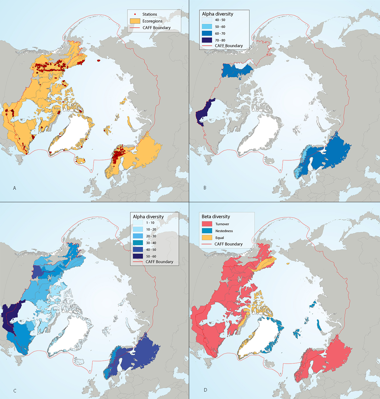
Results of circumpolar assessment of river benthic macroinvertebrates, indicating (a) the location of river benthic macroinvertebrate stations, underlain by circumpolar ecoregions; (b) ecoregions with many river benthic macroinvertebrate stations, colored on the basis of alpha diversity rarefied to 100 stations; (c) all ecoregions with river benthic macroinvertebrate stations, colored on the basis of alpha diversity rarefied to 10 stations; (d) ecoregions with at least two stations in a hydrobasin, colored on the basis of the dominant component of beta diversity (species turnover, nestedness, approximately equal contribution, or no diversity) when averaged across hydrobasins in each ecoregion. State of the Arctic Freshwater Biodiversity Report - Chapter 4 - Page 67 - Figure 4-30
-
(La version française suit) What is an Ecologically and Biologically Significant Area? Ecologically and Biologically Significant Areas (EBSAs) are areas within Canada’s oceansthat have been identified through formal scientific assessments as having special biological or ecological significance when compared with the surrounding marine ecosystem.Failure to define an area as an EBSA does not mean that it is unimportant ecologically. All areas serve ecological functions to some extent and require sustainable management. Rather, areas identified as EBSAs should be viewed as the most important areas where, with existing knowledge, regulators and marine users should be particularly risk averse to ensure ecosystems remain healthy and productive. Why are EBSAs identified? EBSA information is used to inform marine planning, including environmental assessment and the siting of marine-based activities, by: Informing and guiding project-specific or regional environmental assessments; Informing and guiding industries and regulators in their planning and operations, for example: EBSAs have been acknowledged and referred to (often as "Special Areas" or "Potentially Sensitive Areas") in oil and gas related assessments. EBSA information has been provided to proponents of submarine cable projects to be used for route planning purposes. Informing and guiding the Integrated Oceans Management (IOM)process within five Large Oceans Management Areas (LOMAs)and 12 marine bioregions; Serving as a basis for the identification of Areas of Interest (AOIs)and of Marine Protected Areas (MPAs)(individually and in the context of planning bioregional networks of MPAs); How are EBSAs identified? The process used to identify EBSAs is generally comprised of two phases. The first phase involves compiling scientific data and knowledge of a marine area’s ecosystems ─ notably fish species, marine mammals, sea birds, marine flora, marine productivity, physical and chemical conditions and geology. “Knowledge” includes experiential knowledge of long-time uses of the areas. In some cases (e.g., in the Arctic), substantial efforts are taken to collect traditional knowledge on ecosystems and environmental conditions from community members, fish harvests, hunters and individuals whose knowledge of the study area complement and often helps fill scientific data gaps. In the second phase, the available information for a marine area (e.g. a bioregion) is assessed against five nationally-established science-based criteria including: Uniqueness: How distinct is the ecosystem of an area compared to surrounding ones? Aggregation: Whether or not species populate or convene to the study area? Fitness consequence: How critical the area is to the life history of the species that use it (e.g. is it a spawning or feeding ground)? Naturalness: How pristine or disturbed by human activities is the study area? Resilience: What is the ability of the ecosystem to bounce back if it is disturbed? Progress to date and next steps EBSAs have been identified for large portions of Canada’s Atlantic and Pacific oceans as well as most of the Arctic oceans. For a map of current EBSAs in these areas, click here. EBSAs will continue to be identified in priority areas as resources become available to carry out the process. The boundaries or locations of existing EBSAs may be modified to reflect both new knowledge and changing environmental conditions. Les zones d'importance écologique et biologique (ZIEB) sont des zones au sein des eaux océaniques canadiennesque des évaluations scientifiques officielles ont désignées comme ayant une importance écologique et biologique particulière par rapport à l'écosystème marin environnant. Le fait qu'une zone n'ait pas été désignée comme ayant une importance écologique et biologique ne signifie pas pour autant qu'elle n'a pas une importance écologique. Toutes les zones assument des fonctions écologiques dans une certaine mesure et exigent une gestion durable. Les zones désignées comme des ZIEB devraient plutôt être vues comme des zones extrêmement importantes, où les connaissances, les législateurs et les utilisateurs des ressources marines doivent exercer une grande prudence eu égard au risque, afin de veiller à ce que les écosystèmes restent sains et productifs. Pourquoi des ZIEB sont-elles désignées? Les renseignements relatifs à ces aires sont utilisés pour appuyer la planification marine, notamment l'évaluation environnementale et la mise en place d'activités marines: En informant et guidant les industries et les législateurs pour une planification et une conduite d'activités optimale, par exemple: les zones d'importance écologique et biologique ont été prises en compte et mentionnées dans les évaluations portant sur le pétrole et le gaz. Des renseignements ont été fournis aux promoteurs de projets de câbles sous-marins, afin de les aider à en déterminer les tracés. En information et en guidant le processus de gestion intégrée des océans dans cinq zones étendues de gestion des océans et 12 biorégions marines. En servant de fondement pour la détermination des zones d'intérêt et des zones de protection marines (de manière individuelle et dans le cadre de la planification des réseaux biorégionaux de zones de protection marines). Comment désigne-t-on les zones d'importance écologique et biologique? Le processus utilisé pour désigner les zones d'importance écologique et biologique comprend généralement deux étapes. La première étape consiste à recueillir des données scientifiques et des connaissances relatives aux écosystèmes d'une aire marine, notamment les espèces de poissons, de mammifères marins et d'oiseaux marins, la flore marine, la productivité marine, les conditions physiques et chimiques, et la géologie. Les « connaissances » comprennent les connaissances empiriques des utilisateurs de longue date de ces aires. Dans certains cas (p. ex. dans l'Arctique), d'importants efforts sont déployés pour réunir les connaissances traditionnelles sur les écosystèmes et les conditions environnementales des membres des communautés, des pêcheurs, des chasseurs et des personnes dont la connaissance de la zone étudiée complète l'information existante et permet souvent d'aider à combler les lacunes dans les données scientifiques. La deuxième étape consiste à évaluer l'information disponible relative à une aire marine (p. ex., une biorégion) en utilisant cinq critères scientifiques nationaux: La spécificité: dans quelle mesure l'écosystème d'une aire est-il distinct des écosystèmes environnants? La concentration: l'aire étudiée abrite-t-elle des espèces ou est-elle un lieu de regroupement d'espèces? Les conséquences sur la valeur adaptative: dans quelle mesure l'aire est-elle vitale pour le cycle biologique des espèces qui l'utilisent (p. ex., est-ce une zone de frai ou d'alimentation? Le caractère naturel: dans quelle mesure la zone étudiée est-elle demeurée intacte ou est-elle perturbée par les activités humaines? La résilience: dans quelle mesure l'écosystème est-il capable de se rétablir s'il est perturbé? Progrès réalisés à ce jour et prochaines étapes Des zones d'importance écologique et biologique ont été désignées dans une grande partie des eaux océaniques de l'Atlantique et du Pacifique canadien, ainsi que dans la quasi-totalité de l'océan Arctique. À mesure que des ressources seront disponibles pour mener à bien le processus, des zones d'importance écologique et biologique continueront à être désignées dans les zones prioritaires. Les limites ou les emplacements des zones d'importance écologique et biologique existantes sont susceptibles d'être modifiés pour refléter les nouvelles connaissances et conditions environnementales.
-
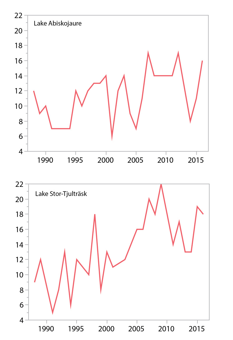
30-year trends in alpha diversity of benthic macroinvertebrates in the stony littoral zones (1 m depth) of two Scandinavian Arctic/alpine lakes: Lake Abiskojaure (upper panel) and Lake Stor-Tjulträsk (lower panel). State of the Arctic Freshwater Biodiversity Report - Chapter 4 - Page 71- Figure 4-35
-
The Canadian Aquatic Biomonitoring Network (CABIN) is an integrated national network for the collection, management, assessment, and distribution of bioassessment data. CABIN aims to provide long-term monitoring and assessment of aquatic ecosystem health by utilizing the Reference Condition Approach (RCA) applied to benthic macro-invertebrates. The CABIN web portal provides access to sampling protocols, on-line data entry and management, and on-line analytical, reporting and visualization tools. Participation in CABIN is encouraged at all levels of expertise; groups interested in becoming involved can contact the program coordinator through the web page (cabin.cciw.ca).
-
The Canadian Aquatic Biomonitoring Network (CABIN) is an integrated national network for the collection, management, assessment, and distribution of bioassessment data. CABIN aims to provide long-term monitoring and assessment of aquatic ecosystem health by utilizing the Reference Condition Approach (RCA) applied to benthic macro-invertebrates. The CABIN web portal provides access to sampling protocols, on-line data entry and management, and on-line analytical, reporting and visualization tools. Participation in CABIN is encouraged at all levels of expertise; groups interested in becoming involved can contact the program coordinator through the web page (cabin-rcba.ec.gc.ca).
 Arctic SDI catalogue