 Arctic SDI catalogue
Precambrian
Type of resources
Available actions
Topics
Keywords
Contact for the resource
Provided by
Formats
Representation types
Update frequencies
status
Scale
Resolution
-

Location of rock samples collected during Precambrian mapping projects more recent than 1985 in northern Saskatchewan and stored at the Subsurface Laboratory. Location of rock samples collected during Precambrian mapping projects more recent than 1985 in northern Saskatchewan and stored at the Subsurface Laboratory. This is an on-going compilation so not all map projects are present. The data was created as a file geodatabase feature class and output for public distribution. **Please Note – All published Saskatchewan Geological Survey datasets, including those available through the Saskatchewan Mining and Petroleum GeoAtlas, are sourced from the Enterprise GIS Data Warehouse. They are therefore identical and share the same refresh schedule.
-
This dataset represents the geochronological ages for selected Precambrian rocks in the province of Saskatchewan, Canada. This dataset represents the compilation of geochronological ages for selected Precambrian rocks in the province of Saskatchewan, Canada. **Please Note – All published Saskatchewan Geological Survey datasets, including those available through the Saskatchewan Mining and Petroleum GeoAtlas, are sourced from the Enterprise GIS Data Warehouse. They are therefore identical and share the same refresh schedule.
-
This dataset represents the radioisoptopic tracers for selected rocks in the province of Saskatchewan, Canada. This dataset represents the compilation of radioisoptopic tracers for selected rocks in the province of Saskatchewan, Canada. **Please Note – All published Saskatchewan Geological Survey datasets, including those available through the Saskatchewan Mining and Petroleum GeoAtlas, are sourced from the Enterprise GIS Data Warehouse. They are therefore identical and share the same refresh schedule.
-
These structure, isopach and zero edge files are part of a series of stratigraphic framework maps for the Saskatchewan Phanerozoic Fluids and Petroleum Systems (SPFPS) project. The series of stratigraphic framework maps for the Saskatchewan Phanerozoic Fluids and Petroleum Systems (SPFPS) project have been produced using 2 km equi-spaced modified grids generated from Golden Software’s Surfer 9 kriging algorithm. The dataset used to produce each of the maps in this series was created using data from several projects completed by the Ministry (Christopher, 2003; Saskatchewan Industry and Resources et al., 2004; Kreis et al., 2004; Marsh and Heinemann, 2006; Saskatchewan Ministry of Energy and Resources et al., 2007; Heinemann and Marsh, 2009); these data were validated and edited as required to facilitate correlations between the various regional projects. In addition, to minimize edge effects during contouring, the senior author also generated stratigraphic data from wells in adjacent jurisdictions.
-
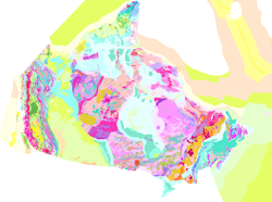
The map displays bedrock formations at or near the surface of the land, on the sea floor above the continental crust that forms the Canadian landmass, and oceanic crust surrounding the landmass. The bedrock units are grouped and coloured according to geological age and composition. The colours of offshore units and oceanic crust are paler and more generalized than those on land, although the constituent units offshore are still easily discernible from their dashed boundaries. This colour design, coupled with the use of a white buffer zone at the coast allows the coastline of Canada to be readily distinguished and still show the grand geological architecture of the Canadian landmass. The map also shows major faults that have disrupted the Earth's crust, onshore and offshore, and a variety of special geological features such as kimberlite pipes, which locally contain diamonds, impact structures suspected to have been caused by meteorites, and extinct and active spreading centres in the surrounding oceans.
-
These structure, isopach and zero edge files are part of a series of stratigraphic framework maps for the Saskatchewan Phanerozoic Fluids and Petroleum Systems (SPFPS) project. The series of stratigraphic framework maps for the Saskatchewan Phanerozoic Fluids and Petroleum Systems (SPFPS) project have been produced using 2 km equi-spaced modified grids generated from Golden Software’s Surfer 9 kriging algorithm. The dataset used to produce each of the maps in this series was created using data from several projects completed by the Ministry (Christopher, 2003; Saskatchewan Industry and Resources et al., 2004; Kreis et al., 2004; Marsh and Heinemann, 2006; Saskatchewan Ministry of Energy and Resources et al., 2007; Heinemann and Marsh, 2009); these data were validated and edited as required to facilitate correlations between the various regional projects. In addition, to minimize edge effects during contouring, the senior author also generated stratigraphic data from wells in adjacent jurisdictions.
-
These structure, isopach and zero edge files are part of a series of stratigraphic framework maps for the Saskatchewan Phanerozoic Fluids and Petroleum Systems (SPFPS) project. The series of stratigraphic framework maps for the Saskatchewan Phanerozoic Fluids and Petroleum Systems (SPFPS) project have been produced using 2 km equi-spaced modified grids generated from Golden Software’s Surfer 9 kriging algorithm. The dataset used to produce each of the maps in this series was created using data from several projects completed by the Ministry (Christopher, 2003; Saskatchewan Industry and Resources et al., 2004; Kreis et al., 2004; Marsh and Heinemann, 2006; Saskatchewan Ministry of Energy and Resources et al., 2007; Heinemann and Marsh, 2009); these data were validated and edited as required to facilitate correlations between the various regional projects. In addition, to minimize edge effects during contouring, the senior author also generated stratigraphic data from wells in adjacent jurisdictions.