 Arctic SDI catalogue
Species at Risk
Type of resources
Topics
Keywords
Contact for the resource
Provided by
Years
Formats
Representation types
Update frequencies
status
Service types
-
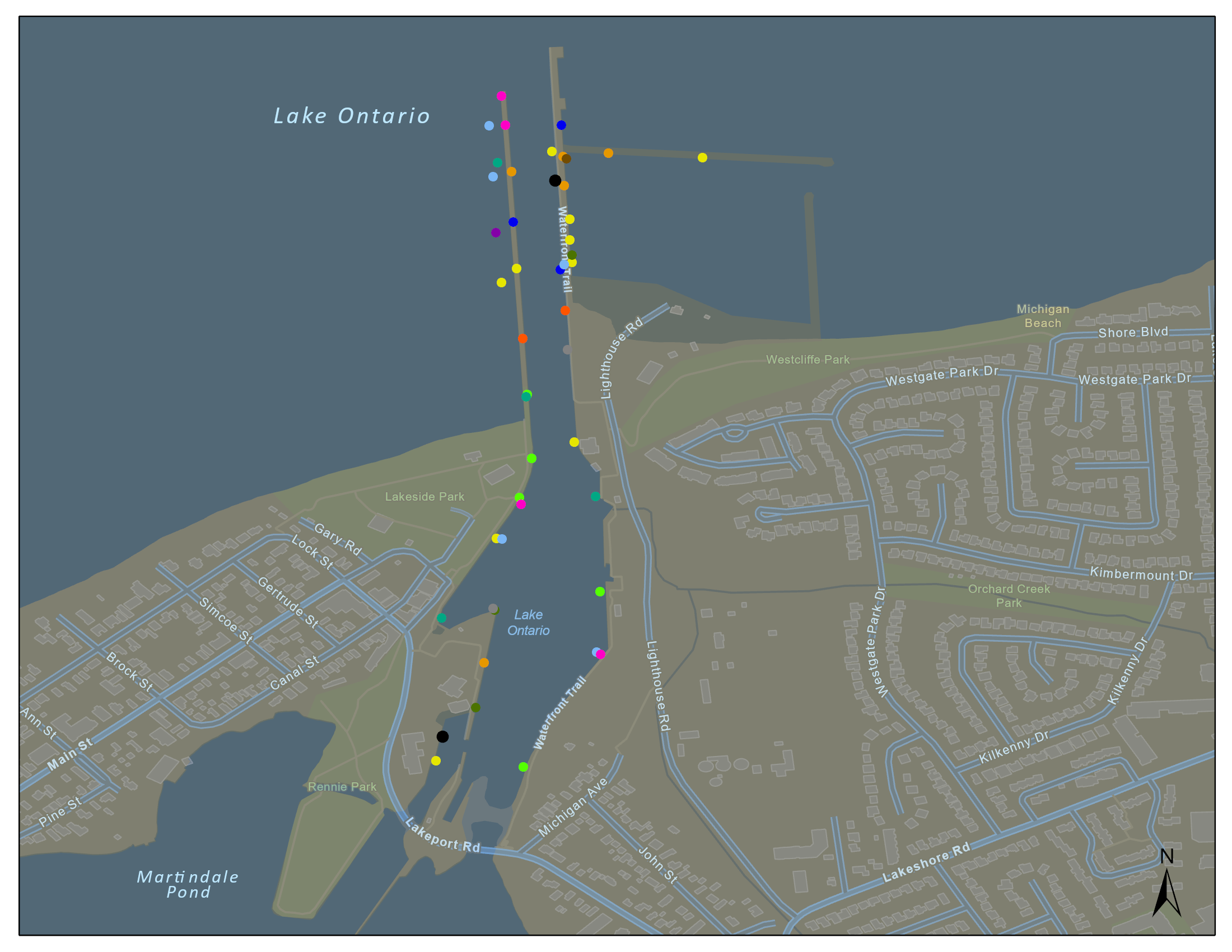
In 2018 and 2019 Fisheries and Oceans Canada conducted a project to relocate American Eel (Anguilla rostrata) from Port Dalhousie Harbour to mitigate potential impacts of in-water construction prior to and during an essential harbour revitalization project. American Eel are designated as Endangered under the Province of Ontario’s Endangered Species Act and were confirmed to be present in the area during initial sampling efforts of this project. While a combination of passive eel traps and boat electrofishing were used to capture eels, this dataset includes passive capture data only. A total of four eels were captured using eel traps and all individuals were relocated to Hamilton Harbour. Only two of the four eels captured were large enough to be tagged with acoustic transmitters, both of which eventually returned to Port Dalhousie from Hamilton Harbour. All other fish species captured in the traps were identified, counted and released at Port Dalhousie.
-
Saskatchewan sections with sensitive habitat for Species at Risk have been identified. Development will be minimized to protect this sensitive habitat or specific mitigation criteria will be required in cases where avoidance is justifiably not possible. For more information, contact the Fish, Wildlife and Lands Branch or the area Ecological Protection Specialist. A total of 3624 Sections in the Prairie Ecozone in Saskatchewan were identified as Sensitive areas for the following Species at Risk, most current information as of December 2015: Burrowing Owl, Eastern Yellow-bellied Racer, Prairie Loggerhead Shrike, Mountain Plover, Mormon Metalmark, Sprague's Pipit, Swift Fox, Black-footed Ferret, Gold-edged Gem, Greater Sage-Grouse, Greater short-horned lizard, Piping Plover, Slender Mouse-ear-cress, Small-flowered Sand-verbena, Tiny Cryptantha, Dusky Dune Moth and Smooth Goosefoot.
-
Critical habitat polygons and lines were assembled by SARA regional biologists and recovery teams. They are designed to support the protection and recovery of species listed as Endangered or Threatened under the Species at Risk Act. They are also described and displayed in species’ Recovery Documents and Action Plans. For the complete extent and view of a species' Critical Habitat both Lines and Polygons must be displayed simultaneously. Please note: there are different types of Critical Habitat descriptors. This dataset may use a “bounding box” or "parcel" approach that delineates an area or extent in which the species may be found. Descriptors (such as bounding box coordinates are not included in this dataset).
-

As part of the Pan-Canadian approach to transforming Species at Risk conservation in Canada, a total of 11 Priority Places were affirmed by federal, provincial, and territorial governments in December 2018. One additional priority place was affirmed in 2024. The places selected have significant biodiversity, concentrations of species at risk, and opportunities to advance conservation efforts. In each Priority Place, the federal and provincial or territorial governments are working with Indigenous Peoples, partners, and stakeholders to develop conservation action implementation plans. Using a defined planning approach (such as the Open Standards for the Practice of Conservation), these implementation plans identify key actions to address the greatest threats to species. Conservation implementation plans provide the foundation for collaborative action on the ground. The federal government, in collaboration with the provinces and territories, has agreed to the implementation of the Pan-Canadian Approach to Transforming Species at Risk Conservation in Canada. This new approach shifts from a single-species approach to conservation to one that focuses on multiple species and ecosystems. This enables conservation partners to work together to achieve better outcomes for Species at Risk. These 12 Priority Places are complemented by a suite of Community-Nominated Priority Places (CNPP), identified through an open call for applications. To learn more about the Priority Places initiative and the work undertaken by our partners to recover Species at Risk within these Priority Places, please visit our interactive website https://environmental-maps.canada.ca/CWS_Storylines/index-ca-en.html#/en/priority_places-lieux_prioritaires
-

This file includes the spatial boundaries for the Pacific Great Blue Heron Potential Area of Occupancy for its entire Canadian range. The Potential Area of Occupancy is a simple model that highlights the heron's preferred forest habitat at a high level. Potential Area of Occupancy is defined as terrestrial areas within the Coastal Douglas Fir and Coastal Western Hemlock Biogeoclimatic zones that are less than 10 km from a potential foraging area and west of the Cascades mountain range. Potential foraging areas are defined as the entire coastline and major river systems less than 1000 m in elevation. Refer to the "Management Plan for the Great Blue Heron fannini subspecies (Ardea herodias fannini) in Canada" on the SARA Regristry for more information.
-

The Olympia oyster (Ostrea lurida Carpenter, 1864) is one of four species of oysters established in British Columbia (BC), Canada, and the only naturally occurring oyster in BC (Bourne 1997; Gillespie 1999, 2009). O. lurida reaches the northern limit of its range in the Central Coast of British Columbia at Gale Passage, Campbell Island, approximately 52°12’N, 128°24’W (Gillespie 2009). First Nations historically utilized Olympia oysters for food and their shells for ornamentation (Ellis and Swan 1981; Harbo 1997). European settlers harvested Olympia oysters commercially from the early 1800s until the early 1930s when stocks became depleted and the industry moved towards other larger, introduced oyster species (Bourne 1997; Quayle 1988). Since that time, Olympia oysters have likely maintained stable populations in BC, but have not recovered to abundance levels observed prior to the late 1800s (Gillespie 1999, 2009). Olympia oysters were designated a species of Special Concern by the Committee on the Status of Endangered Wildlife in Canada (COSEWIC) in 2000 and 2010 and listed under the Species at Risk Act (SARA) in 2003 (DFO 2009; COSEWIC 2011). A management plan was developed and posted to the SARA Public Registry in 2009 (DFO 2009). One of the objectives of this plan was to ensure maintenance of the relative abundance (density) of Olympia oyster at index sites. The plan also recommended development of a survey protocol for determining relative abundance (density) estimates. In response, a Canadian Science Advisory Secretariat (CSAS) Research Document was completed recommending a survey method for Olympia oysters (Norgard et al. 2010); a CSAS Science Advisory Report (DFO 2010) for selection of index sites was also completed. Thirteen index sites were chosen from a mixture of previously surveyed sites, and by random site selection. In 2014, a fourteenth site was added at Joes Bay in the Broken Group area in partnership with Parks Canada. The selected sites provided a representative sample of Olympia oyster populations in different geographic zones in the Pacific region and span the much of the range of Olympia oysters in BC. The number of sites was reduced to six in 2018 so that annual surveys could be completed to better understand population dynamics and identify long-term trends.
-

Cumulative Effects Program (CEP) remote camera detections for the Clear Creek cumulative effects monitoring project that occurred from August 2022 to September 2025. The data presented here is from August 2022- September 2023. Clear Creek remote camera locations can be found on GeoYukon in the Yukon Catalogue. This is a collaborative project with the First Nation of Na-Cho Nyäk Dun (FNNND) and Government of Yukon Department of Environment, with support from Tr’ondëk Hwëch’in. It was undertaken with the financial support of the Department of Environment, the Government of Canada through the federal Department of Environment and Climate Change (Grant Number: GCXE22C217 to FNNND) and through the Canada-Yukon Nature Agreement. For more information about this data please contact ce.cameratrapping@yukon.ca.
-
Critical habitat polygons and lines were assembled by SARA regional biologists and recovery teams. They are designed to support the protection and recovery of species listed as Endangered or Threatened under the Species at Risk Act. They are also described and displayed in species’ Recovery Documents and Action Plans. For the complete extent and view of a species' Critical Habitat both Lines and Polygons must be displayed simultaneously. Please note: there are different types of Critical Habitat descriptors. This dataset may use a “bounding box” or "parcel" approach that delineates an area or extent in which the species may be found. Descriptors (such as bounding box coordinates are not included in this dataset).
-
Cumulative Effects Program (CEP) remote camera detections for the Clear Creek cumulative effects monitoring project that occurred from August 2022 to September 2025. The data presented here is from July/August/September 2024- September 2025. Clear Creek remote camera locations can be found on GeoYukon in the Yukon Catalogue. This is a collaborative project with the First Nation of Na-Cho Nyäk Dun (FNNND) and Government of Yukon Department of Environment, with support from Tr’ondëk Hwëch’in. It was undertaken with the financial support of the Department of Environment, the Government of Canada through the federal Department of Environment and Climate Change (Grant Number: GCXE22C217 to FNNND) and through the Canada-Yukon Nature Agreement. For more information about this data please contact ce.cameratrapping@yukon.ca.
-
Critical habitat polygons and lines were assembled by SARA regional biologists and recovery teams. They are designed to support the protection and recovery of species listed as Endangered or Threatened under the Species at Risk Act. They are also described and displayed in species’ Recovery Documents and Action Plans. For the complete extent and view of a species' Critical Habitat both Lines and Polygons must be displayed simultaneously. Please note: there are different types of Critical Habitat descriptors. This dataset may use a “bounding box” or "parcel" approach that delineates an area or extent in which the species may be found. Descriptors (such as bounding box coordinates are not included in this dataset).