 Arctic SDI catalogue
Tornado
Type of resources
Topics
Keywords
Contact for the resource
Provided by
Formats
Representation types
Update frequencies
status
-

The Multi-Risk Vigilance Card is a product developed by the Ministry of Public Security (MSP) that brings together warnings and reports on phenomena of natural origin that may have consequences on the safety of citizens, goods and services to the population. It is updated continuously automatically. It allows for continuous monitoring of the province's territory in relation to dangerous natural phenomena. Environment and Climate Change Canada weather warnings for blizzard, fog, freezing rain, rain, fog, freezing rain, rain, snow, hail, hurricanes, tropical storms, winter storms, severe storms, tornadoes, tornadoes, storm winds, storm winds, strong winds, strong winds, strong winds, hurricane force winds, high winds, hurricane-force winds, heat waves, and all weather events whose severity* is greater than or equal to moderate; This data comes from the National Alert Aggregation and Dissemination System (ADNA) of the private company Pelmorex. The information conveyed in the alerts complies with the standards of the Common Alert Protocol (PAC). **This third party metadata element was translated using an automated translation tool (Amazon Translate).**
-
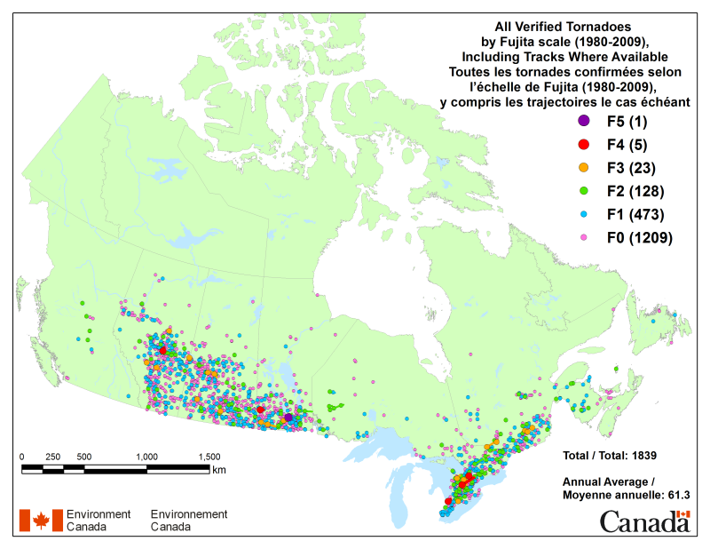
A database of verified tornado occurrences across Canada has been created covering the 30-year period from 1980 to 2009. The data are stored in a Microsoft Excel spreadsheet, including fields for date, time, location, Fujita Rating (intensity), path information, fatalities, injuries, and damage costs. In cases where no data were available, values in the database have been left blank. The tornado data have undergone a number of quality control checks and represent the most current knowledge of past tornado events over the period. However, updates may be made to the database as new or more accurate information becomes available. The database has also been used to produce PNG images and an interactive KML file that can be viewed using Google Earth.
-
A database of verified tornado occurrences across Canada has been created covering the 30-year period from 1980 to 2009. The tornado data have undergone a number of quality control checks and represent the most current knowledge of past tornado events over the period. However, updates may be made to the database as new or more accurate information becomes available. The data have been converted to a geo-referenced mapping file that can be viewed and manipulated using GIS software.
-
A database of verified tornado tracks across Canada has been created covering the 30-year period from 1980 to 2009. The tornado data have undergone a number of quality control checks and represent the most current knowledge of past tornado events over the period. However, updates may be made to the database as new or more accurate information becomes available. The data have been converted to a geo-referenced mapping file that can be viewed and manipulated using GIS software.
-

A database of verified tornado occurrences across Canada has been created covering the 30-year period from 1980 to 2009. The tornado data have undergone a number of quality control checks and represent the most current knowledge of past tornado events over the period. However, updates may be made to the database as new or more accurate information becomes available. The data have been converted to a geo-referenced mapping file that can be viewed and manipulated using GIS software.