 Arctic SDI catalogue
UTM
Type of resources
Available actions
Topics
Keywords
Contact for the resource
Provided by
Years
Formats
Representation types
Update frequencies
status
Service types
-
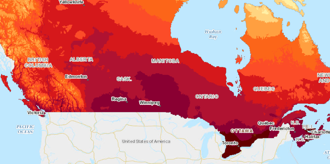
Crop/Corn Heat Units (CHU) is a temperature-based index often used by farmers and agricultural researchers to estimate whether the climate is warm enough to grow corn. Daily crop heat units are calculated from minimum and maximum temperatures with separate calculations for day and night. The daytime relationship sets the minimum at 10 C for growth up to a maximum of 30 C, beyond which growth slows. These values are calculated across Canada in 10x10 km cells.
-

Many geometrical schemes - or map projections - are used to represent the curved surface of the Earth on map sheets. Canada uses the **Universal Transverse Mercator** (UTM) system. It is called transverse because the strips run north-south rather than east-west along the equator. This data class shows a 5 km x 5 km grid coordinate system based on the UTM projection using the North American Datum 83 (NAD83). It includes a UTM Map Sheet Number.
-
Many geometrical schemes - or map projections - are used to represent the curved surface of the Earth on map sheets. Canada uses the **Universal Transverse Mercator** (UTM) system. It is called transverse because the strips run north-south rather than east-west along the equator. This data class shows a 10 km x 10 km coordinate system based on the UTM projection using the North American Datum 83 (NAD83) grid. It includes: * Military Grid Reference- identifies a specific military grid reference system grid cell * Fire Base Map identifier- five digit identifier used by MNR's Aviation and Forest Fire Management Program to identify a fire basemap * Atlas identifier - identifies a specific grid cell * UTM Map Sheet Number - ID number of a UTM mapsheet This product requires the use of GIS software. [UTM Grid - Map Projections ](http://www.nrcan.gc.ca/earth-sciences/geography-boundary/mapping/topographic-mapping/10733)
-
Many geometrical schemes - or map projections - are used to represent the curved surface of the Earth on map sheets. Canada uses the Universal Transverse Mercator (UTM) system. It is called transverse because the strips run north-south rather than east-west along the equator. This data class shows a 1 km x 1 km UTM NAD83 grid that is a standard reference index for Ontario. It includes: * Military Grid Reference * Fire Base Map identifier * Fire Base Map Block * Atlas identifier
-
Many geometrical schemes - or map projections - are used to represent the curved surface of the Earth on map sheets. Canada uses the **Universal Transverse Mercator** (UTM) system. It is called transverse because the strips run north-south rather than east-west along the equator.This data class shows a 100 km x 100 km grid coordinate system based on the UTM projection using the North American Datum 83 (NAD83). It includes: * Military Grid Reference * Atlas identifier
-

Tjenesten inneholder UTMsone, MGRS 100km rute, 10km og 1km UTM rutelinjer. 10km og 1km rutelinjer vil alltid vises i lokal UTM sone, uavhengig av projeksjonen som benyttes.
-
Tjenesten inneholder UTMsone, MGRS 100km rute, 10km og 1km UTM rutelinjer. 10km og 1km rutelinjer vil alltid vises i lokal UTM sone, uavhengig av projeksjonen som benyttes.
-

This document is an Excel spreadsheet that comprises Alberta’s Provincial High Precision Network (HPN). The spreadsheet consists of a subset of the published Alberta Survey Control Markers (ASCMs) with NAD83(CSRS)v7 Epoch 2010 coordinates and CGVD2013 elevations.
-
Created for distribution by the GeoYukon application as a comprehensive resource for all publicly available Reference information in the Yukon Government. This data may be used directly by other applications to dynamically display Yukon data; however, it may be subject to change as data sets are updated or added.
-
Tjenesten inneholder UTMsone, MGRS 100km rute, 10km og 1km UTM rutelinjer. 10km og 1km rutelinjer vil alltid vises i lokal UTM sone, uavhengig av projeksjonen som benyttes.