 Arctic SDI catalogue
Critical Habitat
Type of resources
Topics
Keywords
Contact for the resource
Provided by
Years
Formats
Representation types
Update frequencies
status
Service types
-
Striped Bass critical habitat (St. Lawrence estuary population) defined by the analysis of available knowledge in 2011 and a scientific advice. Purpose The status of the Striped Bass population of the St. Lawrence Estuary is in constant evolution. It went from indigenous population until the end of 1960 to designated extirpated in Canada under the Species at Risk Act (SARA) in 2011. Still in 2011, the status of the population of the St. Lawrence Estuary was reassessed by the Committee on the Status of Endangered Wildlife in Canada (COSEWIC) following the Ministère des Ressources naturelles et de la Faune du Québec re-introduction efforts and was designated endangered (COSEWIC 2012). Under SARA, critical habitat must be designated for all threatened, endangered or extirpated species. Additional Information The analysis of available knowledge on habitat quality assessment and its use by the Striped Bass was realized using two research documents: Pelletier et al. (2010) and Robitaille (2010). These documents were then reviewed during a scientific peer review meeting in April 2010. A Recovery Strategy was also established in 2011. Pelletier, A.-M., G. Verrault, G. Bourget and J. Dussureault. 2010. Utilisation de l’habitat par les différents stades de développement de la population réintroduite de bars rayés (Morone saxatilis) de l’estuaire du Saint-Laurent. Ministère des Ressources naturelles et de la Faune du Québec, Direction de l’Expertise Faune-Forêt-Territoire du Bas-Saint-Laurent. 50 p. Robitaille, J. 2010. Assessment of Habitat Quality and Habitat Use by the Extirped Striped Bass Population (Morone saxatilis) of St. Lawrence Estuary, Quebec DFO Canadian Science Advisory Secretariat. Research Document. 2010/052. 22 p. DFO. 2011. Assessment of Habitat Quality and Habitat Use by the Striped Bass (Morone saxatilis) Population of the St. Lawrence Estuary, Quebec. DFO Can. Sci. Advis. Sec. Sci. Advis. Rep. 2010/069. DFO. 2011. Robitaille, J., M. Bérubé, A. Gosselin, M. Baril, J. Beauchamp, J. Boucher, S. Dionne, M. Legault, Y. Mailhot, B. Ouellet, P. Sirois, S. Tremblay G. Trencia, G. Verreault and D. Villeneuve. 2011. Recovery Strategy for the Striped Bass (Morone saxatilis), St. Lawrence Estuary Population, Canada. Species at Risk Act Recovery Strategy Series. Ottawa : Fisheries and Oceans Canada. xi + 51 p. The available information on habitat used and frequented by the St. Lawrence Estuary striped bass population has been reviewed later than 2011 and can be consulted at: https://open.canada.ca/data/en/dataset/db177a8c-5d7d-49eb-8290-31e6a45d786c
-

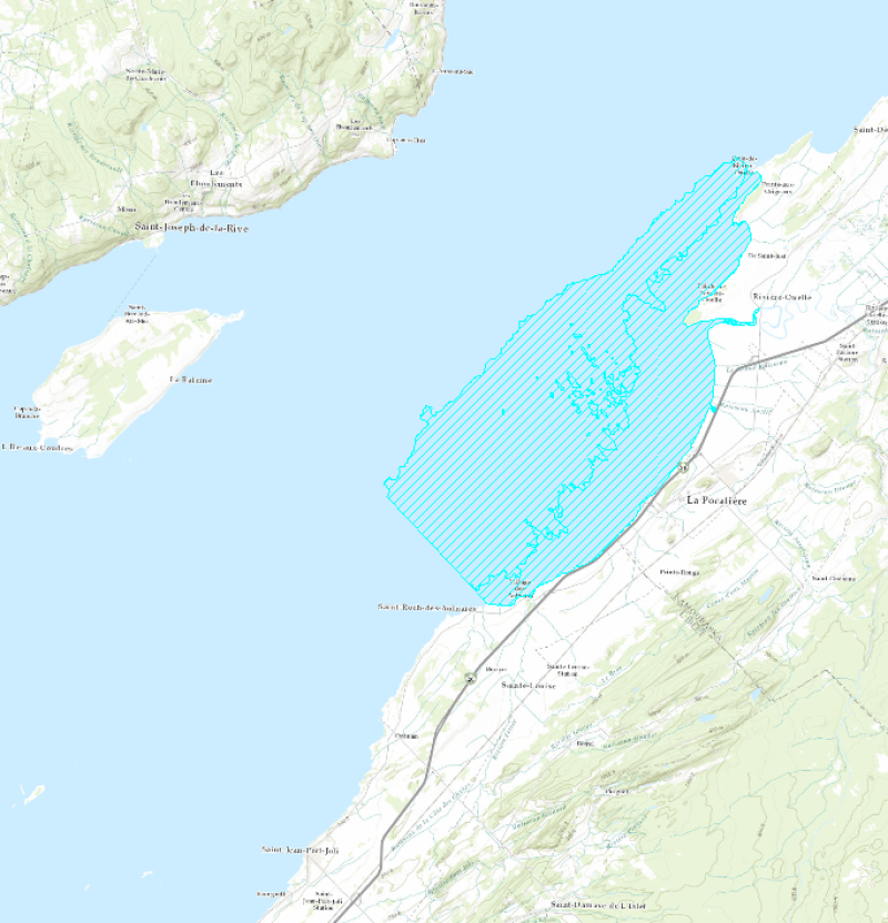
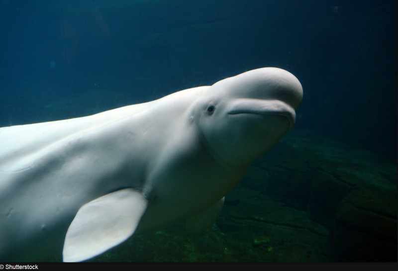
The Beluga whale critical habitat, which includes the Upper Estuary, the Saguenay River up to Sainte-Marguerite Bay, and the southern channel of the Lower Estuary, supports the vital functions of calving and rearing of the young. Due to the lack of information, studies are planned in the near future to increase knowledge of the species. Critical habitat actual limitations could change someday. Purpose The beluga (Delphinapterus leucas) population in the St. Lawrence Estuary was greatly reduced by hunting, which was finally banned in the St. Lawrence in 1979. In May 2005, this beluga population was officially listed as a threatened species on SARA’s List of Wildlife Species at Risk. Additional Information St. Lawrence beluga critical habitat is identified using the best available information. All the available information on its prey, seasonal distribution, use and characteristics of its habitat has been reviewed by Mosnier (2010). This literature review was used to produce a science advisory report reviewed by marine mammal experts. Beluga whale critical habitat has been identified with the information and the scientific advice, using the area of occupancy approach and corresponds to the summer distribution of groups made up of adults and new-born calves and juveniles. Mosnier, A., Lesage, V., Gosselin, J.-F., Lemieux Lefebvre, S., Hammill, M. O., Doniol-Valcroze, T. 2010. Information relevant to the documentation of habitat use by St. Lawrence beluga (Delphinapterus leucas), and quantification of habitat quality. DFO Can. Sci. Advis. Sec., Res. Doc. 2009/098. iv + 35 p. DFO. 2012. Recovery Strategy for the beluga whale (Delphinapterus leucas) St. Lawrence Estuary population in Canada. Species at Risk Act Recovery Strategy Series. Fisheries and Oceans Canada, Ottawa. 88 pp + X pp.
-

The Copper Redhorse (Moxostoma hubbsi) is the only fish whose distribution is exclusively restricted to Quebec. This range is restricted even further to the St. Lawrence River and some of its tributaries. This layer represents the Copper Redhorse critical habitat defined by the analysis of available knowledge and a scientific advice. Purpose The Copper Redhorse population is in decline due to several threats like habitat degradation, construction of dams, contaminants, exotic or introduced species, recreational activities, commercial fishery, and low water levels. Furthermore, certain biological characteristics of the Copper Redhorse contribute to its vulnerability. The Copper Redhorse population was officialy listed as endangered in Schedule I of the Species at Risk Act in December 2007. Additional Information Critical habitat for the Copper Redhorse has been identified to the extent possible, based on the best available information. Two workshops held in 2009 and 2010 by Fisheries and Oceans Canada and the Ministère des Ressources Naturelles et de la Faune du Québec, allowed to review the information and take note of the new data to identify habitat use by the Copper Redhorse in the St. Lawrence and Richelieu rivers and later in the Rivière des Prairies and Rivière des Milles Îles. Adult feeding habitat in the St. Lawrence River between Lake Saint-Louis and Lake Saint-Pierre, was identified using modeling based on the telemetric monitoring of habitat use and on twelve habitat variables (for example: depth, current velocity, vegetation density). Also, recent telemetry and historic data confirmed the use of the lower stretches of the Rivière des Prairies and Rivière des Mille Îles. Critical adult feeding habitat is consequently identified as habitat in the fluvial reach between Montreal and Sorel presenting favorable characteristics for the copper redhorse, used in the model. DFO. 2012. Recovery Strategy for the Copper Redhorse (Moxostoma hubbsi) in Canada. Species at Risk Act Recovery Strategy Series. Fisheries and Oceans Canada, Ottawa. xi+60 pp. https://www.registrelep-sararegistry.gc.ca/document/doc1565p/ind_e.cfm
-
Critical habitat polygons and lines were assembled by SARA regional biologists and recovery teams. They are designed to support the protection and recovery of species listed as Endangered or Threatened under the Species at Risk Act. They are also described and displayed in species’ Recovery Documents and Action Plans. For the complete extent and view of a species' Critical Habitat both Lines and Polygons must be displayed simultaneously. Please note: there are different types of Critical Habitat descriptors. This dataset may use a “bounding box” or "parcel" approach that delineates an area or extent in which the species may be found. Descriptors (such as bounding box coordinates are not included in this dataset).
-

This dataset shows locations that contain critical habitat for certain terrestrial species at risk across Canada. It is intended to provide general guidance only, not legally authoritative boundaries. The dataset includes active critical habitat records for terrestrial species listed on Schedule 1 of the Species at Risk Act (SARA) as Endangered, Threatened, or Extirpated, as well as archived records for species whose status has been downlisted to Special Concern, and for which Environment and Climate Change Canada (ECCC) and/or Parks Canada are responsible. Under SARA, critical habitat means the habitat that is necessary for the survival or recovery of a listed wildlife species and that is identified as the species’ critical habitat in the recovery strategy or action plan for the species. These documents, which are published in the Species at Risk Public Registry (https://www.canada.ca/en/environment-climate-change/services/species-risk-public-registry.html), describe the critical habitat and may include maps or geographic coordinates. Because new information becomes available over time, recovery documents—and the critical habitat they identify—can be updated or revised. The Species at Risk Public Registry is the main source for the most current official information. If there is any difference between this dataset and a recovery document, the recovery strategy or action plan is the authoritative source. Some habitat locations are considered sensitive. For these species, the data may be shown in a less detailed way, or at a broader geographic scale, to avoid increasing risks to the species. For more detailed information on critical habitat, contact the Canadian Wildlife Service at scf-geocarto-cws-geomapping@ec.gc.ca. The data is current as of the date of modification.
-
Layers that present various important parameters such as inventories, presence, sightings, distribution, relative occurrence or catch rates, critical habitat, breeding and feeding areas, potential spawning and haul-out sites for the different species with status under the Species at Risk Act (SARA). The act classifies those species as being either extirpated, endangered, threatened, or of special concern. Under SARA, Fisheries and Oceans Canada must produce recovery strategies and action plans for aquatic species listed as endangered or threatened. The act is part of Canada’s strategy to protect hundreds of wild plants and animal species from becoming extinct, and to help in their recovery. The different species represented by the layers are the following: 1. American shad (Alosa sapidissima) 2. Atlantic sturgeon (Acipenser oxyrinchus) 3. Atlantic wolffish (Anarhichas lupus) 4. Beluga whale (Delphinapterus leucas) 5. Blue whale (Balaenoptera musculus) 6. Copper redhorse (Moxostoma hubbsi) 7. Eelgrass (Zostera marina) 8. Grey seal (Halichoerus grypus) 9. Harbor seal (Phoca vitulina) 10. Humpback whale (Megaptera novaeangliae) 11. Lake sturgeon (Acipenser fulvescens) 12. Lumpfish (Cyclopterus lumpus) 13. Northern wolffish (Anarhichas denticulatus) 14. Rainbow smelt (Osmerus mordax) 15. Sea pens (Pennatulacea) 16. Seaweed 17. Smooth skate (Malacoraja senta) 18. Sponges 19. Spotted wolffish (Anarhichas minor) 20. Striped bass (Morone saxatilis) 21. Thorny skate (Amblyraja radiata) 22. Winter skate (Leucoraja ocellata)