 Arctic SDI catalogue
Magdalen Islands
Type of resources
Topics
Keywords
Contact for the resource
Provided by
Formats
Representation types
Update frequencies
status
-
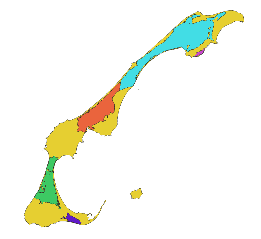
This cartographic dataset represents a geomorphological update of the boundaries of the five inland water bodies that form the Magdalen Islands Marine Refuge. It was produced by Fisheries and Oceans Canada (DFO) as part of its marine refuge characterization work. The data used comes from the August 15, 2022 version of the Quebec maritime Geospatial Database of Coastal Ecosystems (GDB), developed from various sources including satellite and airborne images from 2019 (Jobin et al. 2021; Provencher-Nolet et al. 2024). The boundaries of the inland water bodies were defined according to the upper high tide line, which represents the maximum extent of the water during the highest tides. The final product is a polygonal shapefile representing the five inland water bodies of the marine refuge as well as the terrestrial areas of the archipelago. The data are projected in NAD83 / MTM zone 4. For more information on the method used to generate this layer from the GDB, see Grégoire et al. (2026). The method used to create the source geospatial data is described in Jobin et al. (2021) and Provencher-Nolet et al. (2024).
-
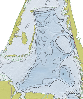
This bathymetric dataset of the five inland water bodies of the Magdalen Islands was produced by the Quebec Regional Science Directorate (DRS) of Fisheries and Oceans Canada (DFO) as part of the characterization of the Magdalen Islands lagoon marine refuge. The data comes from several sources, including a bathymetric LiDAR survey, satellite-derived bathymetry (SDB), acoustic surveys, and spot depth sampling conducted in inland water bodies. The final product is a 5 m resolution raster projected in NAD83 / MTM zone 4. Depths are expressed in meters and reduced to chart datum (CD). This dataset is provided for information, analysis, and research purposes and is not intended for navigation. This dataset is a derived scientific product generated through processing, interpolation, and integration conducted by a DRS research team, and it does not constitute a hydrographic product of the Canadian Hydrographic Service (CHS). The data may contain uncertainties, acquisition artifacts, or processing errors, and do not meet the hydrographic standards of the International Hydrographic Organization (IHO). This dataset is provided exclusively for informational, analytical, management, and scientific research purposes. It must not be used for navigation, for operational decision‑making at sea, or for any activity where the safety of persons or property may depend on the accuracy of depth information. DFO and CHS disclaim all liability for the use, interpretation, or decisions made on the basis of this product. For more information on the methodology and an overview of the results, see the report by Grégoire et al. (2026).
-

Since 1985, research surveys targeting scallops—primarily the sea scallop (Placopecten magellanicus) and, to a lesser extent, the Icelandic scallop (Chlamys islandica)—have been conducted by Fisheries and Oceans Canada (DFO) at one- or two-year intervals around the Magdalen Islands (fishing area 20A). The main objective of this survey is to assess the status of sea scallop stocks. The study area is situated south of the Magdalen Islands, where scallop beds are typically sampled at depths ranging from approximately 25 to 35 m. Sampling stations are randomly selected from a predetermined fixed grid, with sampling conducted along transects at these randomly assigned locations within the study area. Each station is sampled using a lined Digby scallop dredge (20 mm mesh size), towed for roughly 500 m across the seabed. This publication includes three files: the file biometriePetoncle_20, which contains detailed biometric data (species, size, weights and sex) from 1998 to 2024; the file taillePetoncle_20, which provides the size of the individuals sampled from 2009 to 2024; and the file traitPetoncle_20 which contains the abundances and densities per tow from 2009 to 2024. Data on abundances and densities per tow from 1998-2008 is available upon request. This dataset is updated every one to two years as data becomes available. A cleaning of aberrant data has been carried out. However, there is missing data in various columns of the dataset – use the data with caution. If you have any questions please contact DFO.DataManagementSAISB-GestionDonneesDAISS.MPO@dfo-mpo.gc.ca or the author. For certain time periods, associated species are identified and semi-quantitatively counted directly on the sorting table, and the results are presented in the following publications: - https://open.canada.ca/data/en/dataset/6529a4b0-f863-4568-ac71-1fa26cf68679 - https://open.canada.ca/data/en/dataset/71732ad5-5c70-4dbf-916d-a94e1380c53b
-
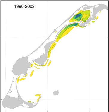
This cartographic dataset of areas of importance for spring herring in the Magdalen Islands was produced by Fisheries and Oceans Canada (DFO) and the Magdalen Islands ZIP Committee, as part of the work to characterize the Magdalen Islands Lagoons Marine Refuge. The initiative aimed to document fishermen's ecological knowledge of spring herring, including good fishing areas and spawning grounds around the archipelago. The data comes from interviews conducted between January and April 2024 with the most experienced fishermen in the archipelago. During the interviews, participants identified directly on digital maps the locations associated with four types of observations made throughout their careers: • Question 8 — Good fishing sites; • Question 9 — Other observations of high concentrations of the resource; • Question 13a — Spawning areas and; • Question 13b — Other observations of signs of spawning. To facilitate temporal contextualization, a four-period timeline (before 1996, 1996-2002, 2003-2006, and 2007-2021) was used. The final product is a GeoPackage (.gpkg) containing 16 vector layers composed of four layers per observation type, each corresponding to one of the defined time periods. The polygons were classified according to the number of fishermen who reported each location, making it possible to assess the degree of overlap and the relative importance of the areas over time. The data are projected in NAD83 / MTM zone 4. For more information on the methodology and data, see Burbank et al. (2025). Additional information specific to the Magdalen Islands lagoons is presented in Grégoire et al. (2026).