 Arctic SDI catalogue
Occurrence
Type of resources
Available actions
Topics
Keywords
Contact for the resource
Provided by
Years
Formats
Representation types
Update frequencies
status
Scale
-
Database of tagged salmonids (Atlantic salmon, brown trout and Arctic char). Carlin tags (smolt) and Lea tags (adult fish) that was tagged in the fish trap on the River Imsa (Rogaland). Recapture of released fish.
-
National database of tagged salmonids (Atlantic salmon, brown trout and Arctic char). Carlin tags (smolt) and Lea tags (adult fish) from various tagging projects in Norway. Recapture of released fish.
-
Database of tagged salmonids (Atlantic salmon, brown trout and Arctic char). Carlin tags (smolt) and Lea tags (adult fish) that was tagged in the fish trap in Talvik, Finnmark. Recapture of released fish.
-
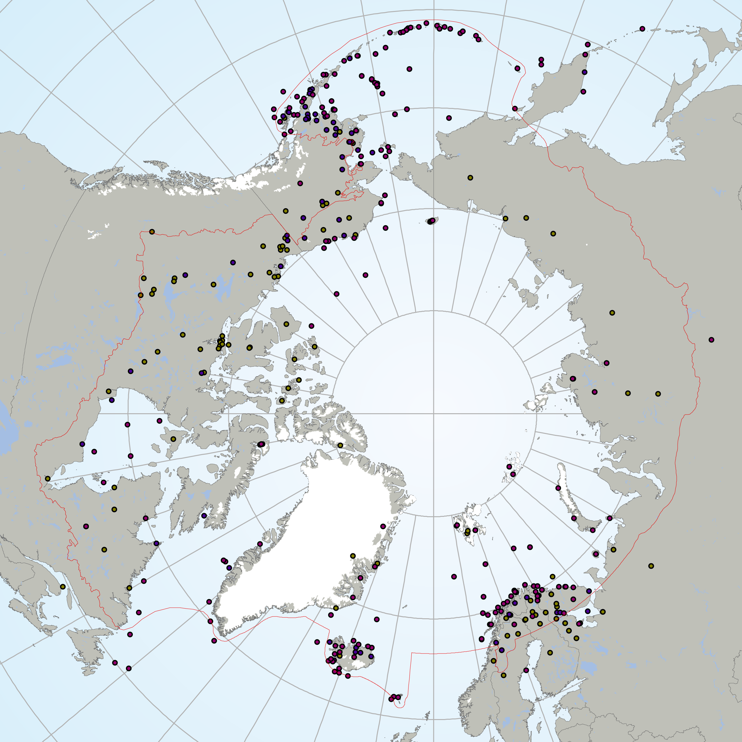
The Circumpolar Biodiversity Monitoring Program, a cornerstone programme of the Conservation of Arctic Flora and Fauna (CAFF), Arctic Council working Group is an international network of scientists, government agencies, Indigenous organizations and conservation groups working together to harmonize and integrate efforts to monitor the Arctic's living resources.CBMP experts are developing four coordinated and integrated Arctic Biodiversity Monitoring Plans to help guide circumpolar monitoring efforts. Results will be channeled into effective conservation, mitigation and adaptation policies supporting the Arctic. These plans represent the Arctic's major ecosystems(Marine, Freshwater, Coastal, Terrestrial). It is important that monitoring programs develop the most effective reporting strategies if they are to inform decision making. To facilitate effective and consistent reporting, the CBMP has chosen a suite of indices and indicators that provide a comprehensive picture of the state of Arctic biodiversity – from species to habitats to ecosystem processes to ecological services. These indices and indicators are developed in a hierarchical manner, allowing users to drill down into the data from the higher-order indices to more detailed indicators. These are being developed through an expert consultation process. The Arctic Species Trend Index (ASTI) is part of this suite of indicators and indices developed by CAFFs CBMP. It tracks trends in over 300 Arctic vertebrate species and comprises the Arctic component of the Living Planet Index. It is important to identify how wildlife and ecosystems are changing in order to develop effective conservation and adaptation strategies in the Arctic, an environment undergoing dramatic changes. The ASTI describes overall trends across species, taxonomy, ecosystems, regions and other categories.
-

Fisheries and Oceans Canada (DFO) selected the Manicouagan Peninsula area as a site of interest for the possible establishment of a Marine Protected Area (MPA) in 1998. With this in mind, DFO conducted surveys to assess benthic biodiversity between 2006 and 2008. During the various campaigns, more than a hundred stations were sampled using various tools to target epibenthic and endobenthic species. Various tools were used during the three years of sampling, including an SM (Smith-McIntyre) grab with an area of 0.1 m² and a height of 20 cm, an IKU-type grab with a surface area of 1.5 m² and a height of 50 cm, and a hydraulic dredge measuring 1.36 m wide and 0.66 m high with a net mesh size of 2.3 cm. As the dredge clogged fairly quickly, small organisms were collected in abundance. In 2006 and 2007, a camera mounted on a sled pulled by a boat along transects of varying lengths depending on the sampling campaign collected images (3,008 x 2,000 pixels) every 10 seconds, representing a seabed area of 40 x 40 cm. The data are presented in Darwin Core format in the file “donnees_manicouagan_data” The available data include taxonomic identifications of samples (individuals collected or identified in images) as well as metadata related to stations, including sampling date, depth, and geographic coordinates. Please note that the depths are for informational purposes only, since the bathymetry is very steep in this region. Further details on sampling can be found in the following report: Provencher, L et Nozères, C. 2011. Protocole de suivi des communautés benthiques de la zone de protection marine Manicouagan. Secr. can. de consult. sci. du MPO. Doc. de rech. 2011/051. iv +25 p. https://waves-vagues.dfo-mpo.gc.ca/library-bibliotheque/344357.pdf
-
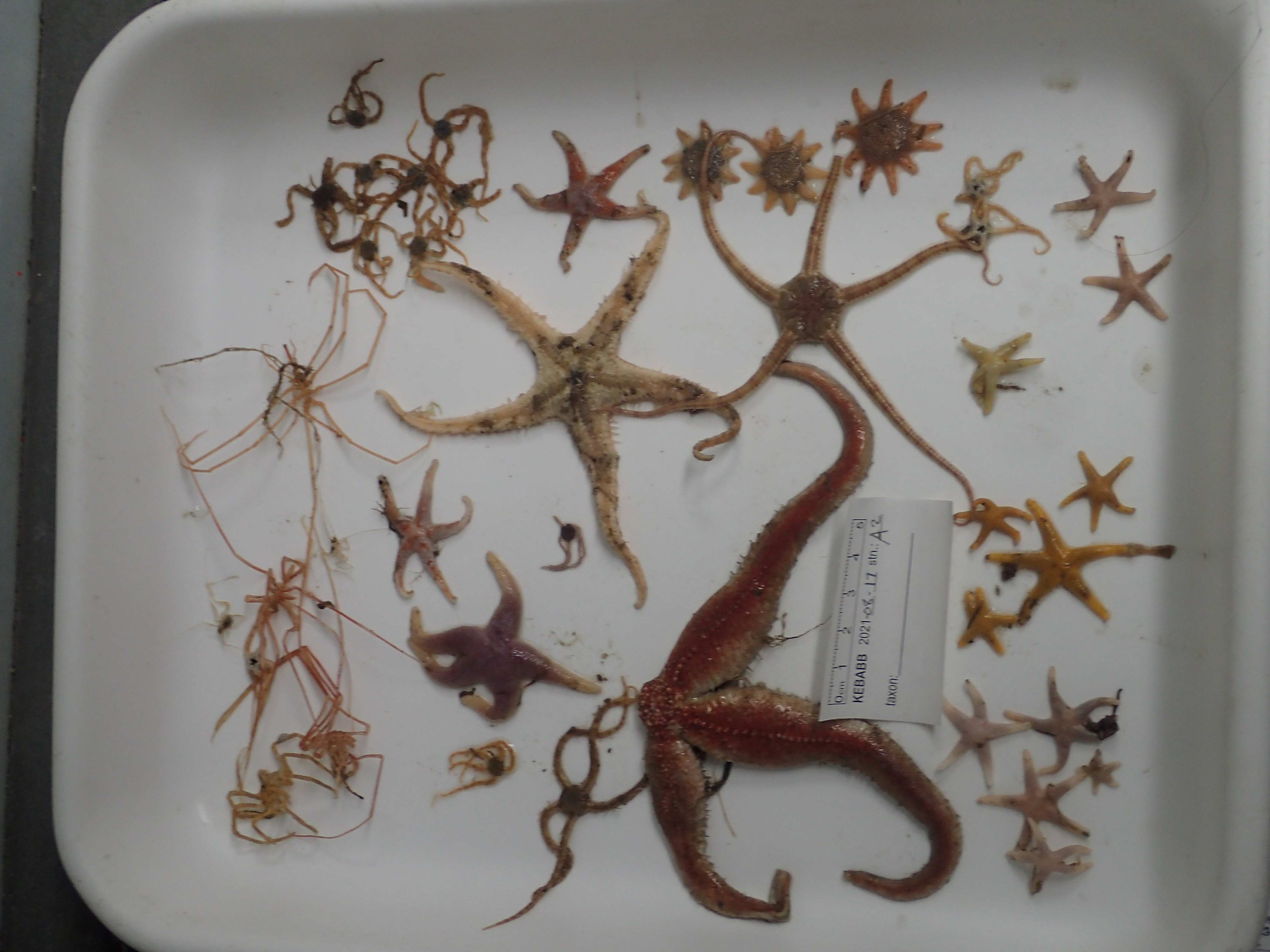
This resource documents a dataset of epifauna occurrences collected in 2021 during The Knowledge and Ecosystem-Based Approach in Baffin Bay (KEBABB) program developed by the Department of Fisheries and Oceans Canada (DFO) in collaboration with university partners. The overall objective of KEBABB is to characterize the variability and trends in physical, chemical, and biological oceanographic conditions and food webs supporting fisheries in the connected ecosystems of western Baffin Bay and Lancaster Sound. In 2021, DFO expanded the KEBABB program to Barrow Strait (KEBABS-Knowledge and Ecosystem-Based Approach in Barrow Strait), a key productive area of the Tallurutiup Imanga National Marine Conservation Area. The study took place in the Eastern Canadian Arctic (mainly in Baffin Bay, Davis Strait and Barrow Strait). Sampling is done along transects at fixed stations in the study area. Catches are collected with a 1.5 m Agassiz trawl (5 mm mesh net) for 3 minutes bottom-contact time at a target speed of 1.5 knots and with a 3 m benthic beam trawl (6.4 mm mesh net) for 15 minutes bottom-contact time at a target speed of 3 knots. A total of 16 stations were sampled for epifauna in 2021 between 85-850 m depth. Epibenthic invertebrates are identified to the lowest possible taxonomic level and photographed. All unknown specimens are frozen. In the lab, the identifications are validated or refined with the photos and the frozen specimens. The data are presented in Darwin Core and are separated in two files: The “Activité_épifaune_KEBABB_epifauna_event_en” file which contains information about missions, stations and deployments, which are presented under a hierarchical activity structure. The “Occurrence_épifaune_KEBABB_epifauna_en” file that contains the taxonomic occurrences. Further details on sampling can be found in the following report: Pućko, M., Charette, J., Tremblay P., Brulotte S., St-Denis B., Ciastek S., Hedges, K., Kuzyk, Z., Roy V., and Michel, C. 2022. An ecosystem-based approach in the eastern Arctic: KEBABB/S (Knowledge and Ecosystem-Based Approach in Baffin Bay/Barrow Strait) 2021 expedition report. Can. Manuscr. Rep. Fish. Aquat. Sci. 3250: viii + 58 p. https://publications.gc.ca/collections/collection_2022/mpo-dfo/Fs97-4-3250-eng.pdf USE LIMITATION: To ensure scientific integrity and appropriate use of the data, we would encourage you to contact the data custodian.
-

The Planning for an Environmental Response (PIER) initiative falls under the umbrella of the Government of Canada’s Oceans Protection Plan (OPP), whose goal is preserving marine ecosystems vulnerable to increased transportation and the development of the marine industry. The PIERs’ main mandate is to acquire and update biological sensitivity data under its jurisdiction for preparation and response purposes in the event of an oil spill. This dataset contains all observations of marine organisms noted during the analysis of 2959 underwater images sampled over a large extent of the coastal zone (≤10 m) of the Estuary and the Gulf of St. Lawrence (Quebec region). The dataset includes 21 490 occurrences of 150 taxa and informal categories including macroalgae, invertebrates and fish. Underwater images were collected between 2017 and 2021 according to a directed sampling protocol whose primary goal was to map large seaweed and eelgrass beds. Images were normally recorded as videos using a GoPro Hero camera installed on a pole and placed near the seabed from a small boat. The collected data served primarily as ground-truth data to validate coasting zone mapping based on aerial photographs within the framework of the PIER's initiative. The two files provided (DarwinCore format) are complementary and are linked by the "eventID" key. The "event_information" file includes generic event information, including date and location. The "taxon_occurrence" file includes the original identifiers of the observed organisms (verbatimIdentification field), identification remarks and their taxonomy. Taxonomic names were verified on the World Register of Marine Species (WoRMS) to match recognized standards. The WoRMS match has been put in the scientificNameID field in the occurrence file. Data quality control was performed using the R packages obistools and worrms. All sampling locations were plotted on a map to perform a visual check confirming that the latitude and longitude coordinates were within the described sampling area. A visual dictionary was developed as an identification aid and accompanies this dataset (unilingual french only, the English version will be published soon). More data, including a visibility index, estimated macroalgae and eelgrass cover, substrate type and dominant macroalgae and animals were recorded but not included in this dataset. These data may be made available upon request. Credits Provencher-Nolet, L., Paquette, L., Pitre, L.D., Grégoire, B. and Desjardins, C. 2024. Cartographie des macrophytes estuariens et marins du Québec. Rapp. Tech. Can. Sci. halieut. Aquat. 3617 : v + 99 p. Grégoire, B., Pitre, L.D., Provencher-Nolet, L., Paquette, L. and Desjardins, C. 2024. Distribution d’organismes marins de la zone côtière peu profonde du Québec recensés par imagerie sous-marine de 2017 à 2021. Rapp. tech. can. sci. halieut. aquat. 3616 : v + 78 p.
-

An exploratory project on the taxonomic and genetic diversity of decapods in three ocean subregions (Northeast Pacific, Canadian Arctic, and Northwest Atlantic), which were sampled in 2022, was undertaken by the Arctic Working Group under the Canada-U.S. Fisheries and Climate Collaboration between Fisheries and Oceans Canada (DFO) and the National Marine Fisheries Service (NMFS) of the National Oceanic and Atmospheric Administration (NOAA). This collaboration framework aims to pool Canadian and U.S. data to explore the impacts of broad-scale climate change on marine biodiversity. In early summer 2022, a sampling protocol with the selection of targeted decapods was provided to DFO and NOAA collaborators. Targeted genera were collected from a total of 10 research programs across three ocean subregions and four marine regions. The Northeast Pacific samples were collected in the Bering Sea during the Northern Bering Sea Ecosystem and Surface Trawl Survey, and the Eastern and Northern Bering Sea Continental Shelf Bottom Trawl Survey of Groundfish and Invertebrate Fauna onboard the F/V Northwest Explorer, F/V Alaska Knight and F/V Vesteraalen. In the Western Canadian Arctic (mainly from Beaufort Sea and Amundsen Gulf), specimens were collected during DFO’s Canadian Beaufort Sea – Marine Ecosystem Assessment (CBS-MEA) survey onboard the F/V Frosti. In Eastern Canadian Arctic (mainly from Baffin Bay and Davis Strait), specimens were collected during DFO’s Knowledge and Ecosystem-Based Approach in Baffin Bay (KEBABB) survey onboard the CCGS Amundsen and DFO’s North Atlantic Fisheries Organization (NAFO) Subarea 0B survey onboard the R/V Tarajoq. In the Estuary and Gulf of St. Lawrence (EGSL), specimens were collected from coastal surveys (scallops, sea cucumber, snow crab, and whelk surveys) onboard the CCGS Leim and offshore during the Ecosystemic Survey onboard the CCGS Teleost. Decapods were collected from various sampling gears (benthic beam trawl, modified Atlantic Western IIA otter trawl, Bacalao trawl, shrimp trawl, Digby scallop dredge, or modified sea cucumber dredge) and identified to the lowest possible taxonomic level and photographed, when possible. All specimens were frozen at sea (n = 995). In the lab, the identifications were validated or refined with the photos and the frozen specimens. DNA was extracted for 87 specimens and a section of COI gene was amplified in order to be sequenced using Sanger method. Sequences were compared with existing data using The Basic Local Alignment Search Tool (BLAST) in the National Center for Bio-technology Information Nucleotide database (NCBI-nt, including the GenBank database) to compare scientific names, where available. The present dataset includes 391 decapod species occurrences. DNA was extracted for a subset of 87 specimens (COI gene); sequences are publicly available on BOLD data portal under project code DDAO (see supporting document "citations_references.csv" for more information). The data are presented in Darwin Core format and are separated in three files: The "Activité_décapodes_DDAO_decapods_event_en" file contains information about missions, stations and deployments, which are presented under a hierarchical activity structure. The "Occurrence_décapodes_DDAO_decapods_en" file contains the taxonomic occurrences. The "ADN_décapodes_DDAO_decapods_DNA_en" file contains the DNA derived data. For further details, please refer to the technical report available in the supporting document named "citations_references.csv". USE LIMITATION: To ensure scientific integrity and appropriate use of the data, we would encourage you to contact the data custodian.