 Arctic SDI catalogue
Offshore area
Type of resources
Available actions
Topics
Keywords
Contact for the resource
Provided by
Formats
Representation types
Update frequencies
status
-

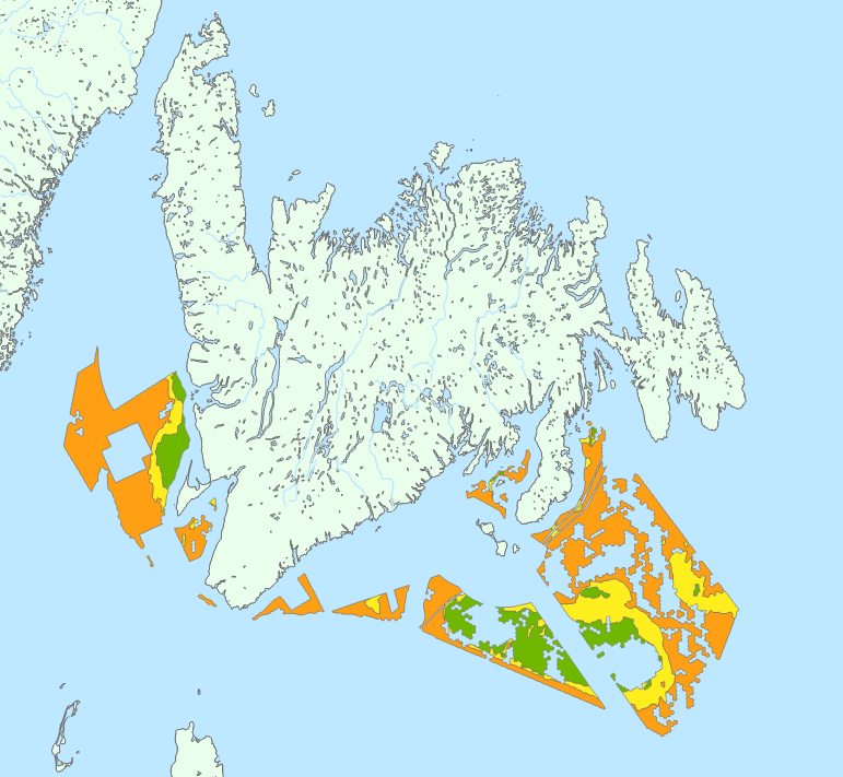
The Environmental Studies Research Fund (ESRF) Regions are legally described in Part I and Part II of the Schedule in the Environmental Studies Research Fund Regions Regulations in the Canada Petroleum Resources Act. This data collection is for illustrative purposes only and includes: • 1 dataset illustrating ESRF prescribed regions 1 to 31 as they are described in the ESRF Regions Regulations. • 1 dataset illustrating the areas where levies are no longer applied to ESRF prescribed regions. These areas include lands that are described in the ESRF Regions Regulations but have since been devolved to the Government of Yukon or the Government of Northwest Territories as part of the 2003 Yukon Devolution and 2014 Northwest Territories Devolution, respectively. Once the Yukon Act and Northwest Territories Act came into effect, lands subject to devolution were no longer considered frontier lands or Canada lands, and therefore no longer subject to ESRF levies under the Canada Petroleum Resources Act. The geospatial extents used in this dataset represent those identified in the Devolution Agreements. Future updates to Part II, section 3 of the Schedule in the ESRF Regions Regulations will reflect the Yukon and Northwest Territories Devolutions. • 3 maps (National, North, South). • 1 table compiling the historical levies for each ESRF prescribed region. Context: The Environmental Studies Research Fund (ESRF) is a research program which sponsors environmental and social studies designed to assist in the decision-making process related to oil and gas exploration and development on Canada's frontier lands. The ESRF is directed by a 12-member Management Board which includes representation from the federal government, the Canada-Newfoundland and Labrador Offshore Petroleum Board (C-NLOPB), the Canada-Nova Scotia Offshore Energy Regulator (CNSOER), the oil and gas industry, and the public. The ESRF is administered by a secretariat which resides in the Offshore Management Division in Natural Resources Canada. Since 1987, the ESRF has received its legislative mandate through the Canada Petroleum Resources Act. The ESRF regions are described in the Environmental Studies Research Fund Regions Regulations. As well, the Canada-Newfoundland and Labrador Atlantic Accord Implementation Act and the Canada–Nova Scotia Offshore Petroleum Resources Accord Implementation and Offshore Renewable Energy Management Act provide legislative direction in the southern ESRF regions. Funding for ESRF is collected annually through levies paid by lease-holding oil and gas companies active in a specific ESRF region. In accordance with the legislation, levies are recommended by the Management Board to the Ministers of Natural Resources and Crown-Indigenous Relations and Northern Affairs for approval. Levies in the southern regions in areas governed by an offshore Accord are subject to final approval by the respective offshore regulator (i.e., the C-NLOPB, or the CNSOER). Levies are calculated by multiplying the levy rate of a region by the number of hectares of land under lease. The ESRF has sponsored studies on biodiversity; environmental effects and monitoring; social and economic issues; ice, icebergs, and ice detection; oil spill research and countermeasures; sea bottom ice scour; sediment transport; Indigenous Knowledge; and waves.
-

The Oil and Gas Rights dataset contains the digital boundaries for existing exploration licences, significant discovery licences, production licences, former permits, former leases and the Norman Wells Proven Area. These boundaries are available for download on the Northern petroleum pesources Website at https://www.rcaanc-cirnac.gc.ca/eng/1100100036087/1538585604719. The Oil and Gas Rights dataset is Crown-Indigenous Relations and Northern Affairs Canada (CIRNAC) and Indigenous Services Canada (ISC) primary source for northern petroleum titles geographic location on maps.
-
This geospatial data depicts preliminary offshore wind licencing areas recommended by the Committee for the Regional Assessment of Offshore Wind Development in Newfoundland and Labrador (Committee). These areas were identified as an interim product during the Regional Assessment process. The Committee is tasked to complete its Regional Assessment Report by January 2025. As part of the terms of amended agreement set out by the Governments of Canada and Newfoundland and Labrador, the Committee submitted an interim report to Ministers on March 22, 2024. This report included a preliminary map of recommended areas for offshore wind. Based on work completed to date, the Committee has found these areas are where offshore wind development is most likely feasible and will have the least impact within offshore Newfoundland and Labrador. These areas are preliminary and will be refined throughout the remainder of the Regional Assessment. Through the Regional Assessment process, the Committee is providing federal and provincial Ministers with information, knowledge, and analysis regarding future offshore wind development. Their work is intended to inform and improve future planning, licencing, and impact assessment processes. Any offshore wind areas identified by the Committee do not reflect official offshore wind licencing areas. The Committee is providing these areas to Ministers for their consideration, as the offshore wind regulatory process is being established.
-

This geospatial data depicts the Draft Offshore Wind Licencing Areas (Draft Areas) recommended by the Committee for the Regional Assessment of Offshore Wind Development in Newfoundland and Labrador (Committee).* Based on work completed to date, the Committee has found the Draft Areas are where offshore wind development would have the least impact within the Regional Assessment Focus Area. Identifying Areas: Section 6 of the Draft Regional Assessment Report (see Data Resources below) includes details on how the Draft Areas were identified. They are the result of the constraints analysis summarized below, with very little modification to area boundaries. The Committee successively removed areas from the Regional Assessment Focus Area (published on Open Government by the Impact Assessment Agency on December 1, 2023). Constraints analysis steps included: • Step 1: Creating Coastal Buffers. • Step 2: Removing Marine Critical Habitat. • Step 3: Removing Marine Protected Areas. • Step 4: Removing Marine Traffic Routes. • Step 5: Removing Areas with High Vessel Traffic. • Step 6: Removing the South Coast Fjords NMCA Study Area. • Step 7: Removing Areas around National Parks & World Heritage Sites. • Step 8: Removing High Density Fishing Areas. • Step 9: Removing Community-based Coastal Resources. An Iterative Process: Identifying offshore wind licencing areas is an iterative process. On March 22, 2024, the Committee submitted its Interim Report to Ministers. This report included a preliminary map of recommended areas for offshore wind development licencing. The preliminary areas were updated based on engagement outcomes, additional data and analysis submitted to the Committee by Regional Assessment participants, and additional research and analysis completed by the Committee between March and October 2024. On October 1, 2024, the Committee’s Draft Report, including updated offshore wind areas, was published for a public comment period. The Draft Areas supersede the Preliminary Offshore Wind Licencing Areas. The Draft Areas are also subject to change. The Committee will submit its Final Report and Initial Offshore Wind Licencing Areas for Consideration to Ministers on or before January 23, 2025. The Committee recommends that regulators consider the forthcoming Initial Offshore Wind Energy Licencing Areas, and the Committee’s report to Ministers, to help inform offshore wind development licencing areas in the region. Latest Update: The Committee’s Final Report and final version of Initial Offshore Wind Energy Licencing Areas for Consideration were submitted to Ministers on January 23, 2025. This completes the Committee’s mandate. Ministers may also choose to make the final versions of these areas available following the Regional Assessment. However, no changes have been made to the geospatial data representing the Draft Areas (published here). Please note the Committee updated the term “Initial Offshore Wind Energy Licencing Areas for Consideration” in the final iteration of their work to better communicate the areas it identified are not licencing areas but are a starting point to help inform the selection of licencing areas. Previous iterations of these areas were called Preliminary Offshore Wind Licencing Areas and Draft Offshore Wind Licencing Areas. *Regional Assessment Background: The federal Ministers of Environment and of Natural Resources, and the provincial Ministers of Industry, Energy and Technology, of Environment and Climate Change, and of Intergovernmental Affairs (Ministers) are signatory to the Regional Assessment Agreement. The goal of the Regional Assessment is to provide information to federal and provincial governments to help them plan for offshore wind development in Newfoundland and Labrador, and complete impact assessments of offshore wind projects. Federal and provincial Ministers appointed an independent committee, comprising five members of diverse backgrounds and expertise to conduct the assessment.
-

This geospatial data depicts potential development areas (PDAs) recommended by the Committee for the Regional Assessment of Offshore Wind Development in Nova Scotia. The Committee for the Regional Assessment of Offshore Wind Development in Nova Scotia (Committee) provides federal and provincial Ministers with information, knowledge, and analysis regarding future offshore wind (OSW) development in Nova Scotia. Its work is intended to inform and improve future planning, licencing, permitting, and impact assessment processes. Under the Terms of Reference, the Committee submitted an interim report to Ministers on March 23, 2024. This report included the preliminary identification of recommended areas for potential future development areas (PFDAs) for offshore wind. Based on work completed since the interim report, the Committee issued its final report on January 23, 2025, which included refined development areas, the Potential Development Areas (PDAs). These PDAs are based on technical feasibility (using available information) and have the least impact on other offshore users. It should be noted that the PDAs are recommendations only and do not reflect official offshore wind energy areas.
-

This geospatial data depicts potential future development areas recommended by the Committee for the Regional Assessment of Offshore Wind Development in Nova Scotia. These areas were identified as an interim product during the Regional Assessment process. They do not reflect official offshore wind licencing or development areas. The Committee for the Regional Assessment of Offshore Wind Development in Nova Scotia (Committee) is providing federal and provincial Ministers with information, knowledge, and analysis regarding future offshore wind development (OSW). Their work is intended to inform and improve future planning, licencing, permitting, and impact assessment processes. The Committee is tasked to complete its Regional Assessment Report by January 2025. As part of the terms of the amended agreement set out by the Governments of Canada and Nova Scotia, the Committee submitted an interim report to Ministers on March 22, 2024. This report included the preliminary identification of recommended areas for potential future offshore wind. Based on work completed to date, the Committee has identified areas where offshore wind development is technically feasible (based on available information) and will have the least impact within other offshore users. These areas are preliminary and will be refined throughout the remainder of the Regional Assessment. The offshore wind areas identified by the Committee do not reflect official offshore wind licencing areas. The Committee is providing these areas to Ministers for their consideration, as the offshore wind regulatory process is being established.
-
Survey records are the legal survey documents (plans, field notes, reports, diaries) that reflect the work done on the ground. The Canada Lands Survey Records provide a mechanism to ensure safekeeping of and access to legal survey documents for Canada Lands.
-

Basic biological data for all fish caught during the 2012 BSMFP expedition. Includes identification, weight, length (total, fork, and, standard), liver weight, gonad weight, sex and maturity level.
-
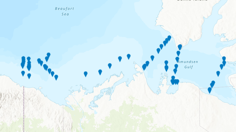
PURPOSE: From August 2nd to September 9th, 2013, Fisheries and Oceans Canada conducted a baseline survey of marine fishes and their habitats in the southern Canadian Beaufort Sea and Amundsen Gulf as part of the Beaufort Regional Environmental Assessment (BREA) called the Beaufort Sea Marine Fishes Project (BSMFP). Sampling was conducted from the F/V Frosti at 53 stations along 8 transects. Standardized sampling was conducted using benthic trawling nets. The BSMFP is the first research project to use a large research trawls to assess the biodiversity and abundance of offshore marine fishes in this area. In total, 48 species of fish were caught, one of which was a new occurrence in the Canadian Beaufort Sea, Lycodes lavalaei. DESCRIPTION: Basic biological data for all fish caught during the 2013 BSMFP expedition. Includes identification, weight, length (total, fork, and, standard), liver weight, gonad weight, sex and maturity level. PARAMETERS COLLECTED: family species weight total length fork length standard length liver weight gonad weight sex maturity SAMPLING METHODS: Various trawl types.
-

From August 5th to September 3rd, 2012, Fisheries and Oceans Canada conducted a baseline survey of marine fishes and their habitats on the Canadian Beaufort Shelf and slope. Sampling was conducted from the F/V Frosti at 28 stations along four transects. Standardized sampling was conducted at pre-determined depth stations (20-40, 75, 200, 350, 500, 750, and 1000 m) using a variety of sampling equipment including benthic fishing trawls, plankton nets, sediment cores, and CTD and water sample profiles. A specialized CTD probe (UCTD) was deployed at an additional 30 locations while the ship was underway. Presented here is the information on the sampling locations, and the sampling gear deployed at each station.