 Arctic SDI catalogue
Quaternary
Type of resources
Available actions
Topics
Keywords
Contact for the resource
Provided by
Years
Formats
Representation types
Update frequencies
status
Service types
Scale
-

This dataset represent the Ice Flow Indicator compilation for the province of Saskatchewan. This dataset represents glacial ice flow indicators compiled from recent and historical bedrock and surficial geology maps and digital datasets. The data was created as file geodatabase feature class and output for public distribution. **Please Note – All published Saskatchewan Geological Survey datasets, including those available through the Saskatchewan Mining and Petroleum GeoAtlas, are sourced from the Enterprise GIS Data Warehouse. They are therefore identical and share the same refresh schedule.
-
Compilation of drillholes for mineral exploration and Quaternary studies in the Province of Saskatchewan, Canada. This dataset is compilation of uranium drillholes prior to 2007, and since that time has expanded to include metallic and industrial mineral exploration drillholes and surficial sedimentology drillholes. This is an ongoing compilation whereby recent drillholes that become publically available are added. In addition, improvements are frequently made to more historic drillholes with spurious information. The dataset is not an exhaustive list of drillholes in Saskatchewan. **Please Note – All published Saskatchewan Geological Survey datasets, including those available through the Saskatchewan Mining and Petroleum GeoAtlas, are sourced from the Enterprise GIS Data Warehouse. They are therefore identical and share the same refresh schedule.
-
This map service provides access to the 1:250 000 Scale Geology datasets shown on the GeoAtlas application. This dataset shows 1:250,000 scale Quaternary geology line work for the Province of Saskatchewan. Mapping in support of the data includes many years or field observations complied at 1:250 000 scale and integrated into this dataset. The data was created as a file geodatabase feature class and output for public distribution. **Please Note – All published Saskatchewan Geological Survey datasets, including those available through the Saskatchewan Mining and Petroleum GeoAtlas, are sourced from the Enterprise GIS Data Warehouse. They are therefore identical and share the same refresh schedule.
-
This dataset represents surface to bedrock isopach (thickness in metres) map of glacial drift for the Province of Saskatchewan at 1:1 000 000 scale. This dataset represents surface to bedrock isopach (thickness in metres) map of glacial drift at 1:1 000 000 scale. This data was created as a file geodatabase feature class and output for public distribution. **Please Note – All published Saskatchewan Geological Survey datasets, including those available through the Saskatchewan Mining and Petroleum GeoAtlas, are sourced from the Enterprise GIS Data Warehouse. They are therefore identical and share the same refresh schedule.
-
This dataset shows the surficial geology lines for the Province of Saskatchewan and is designed for the Resource Map of Saskatchewan. This dataset shows the surficial geology lines for the Province of Saskatchewan and is designed for the Resource Map of Saskatchewan. Mapping in support of the dataset includes years of field observations which were then compiled and integrated into this dataset. The data was created as a file geodatabase feature class and output for public distribution. 1:1,000,000 scale surficial geology lines map of Saskatchewan symbol layer. **Please Note – All published Saskatchewan Geological Survey datasets, including those available through the Saskatchewan Mining and Petroleum GeoAtlas, are sourced from the Enterprise GIS Data Warehouse. They are therefore identical and share the same refresh schedule.
-
This dataset is a digital representation of Saskatchewan's Quaternary geology at 1:250 000 scale. This dataset is a 1:250,000 scale Quaternary geology map series showing surficial terrain deposits classified by depositional environment and geomophology in the Province of Saskatchewan. Mapping of this dataset was compiled by Agriculture and Agri-Food Canada and Prairie Farm Rehabilitation Administration (PFRA), and merged by the Government of Saskatchewan. **Please Note – All published Saskatchewan Geological Survey datasets, including those available through the Saskatchewan Mining and Petroleum GeoAtlas, are sourced from the Enterprise GIS Data Warehouse. They are therefore identical and share the same refresh schedule.
-
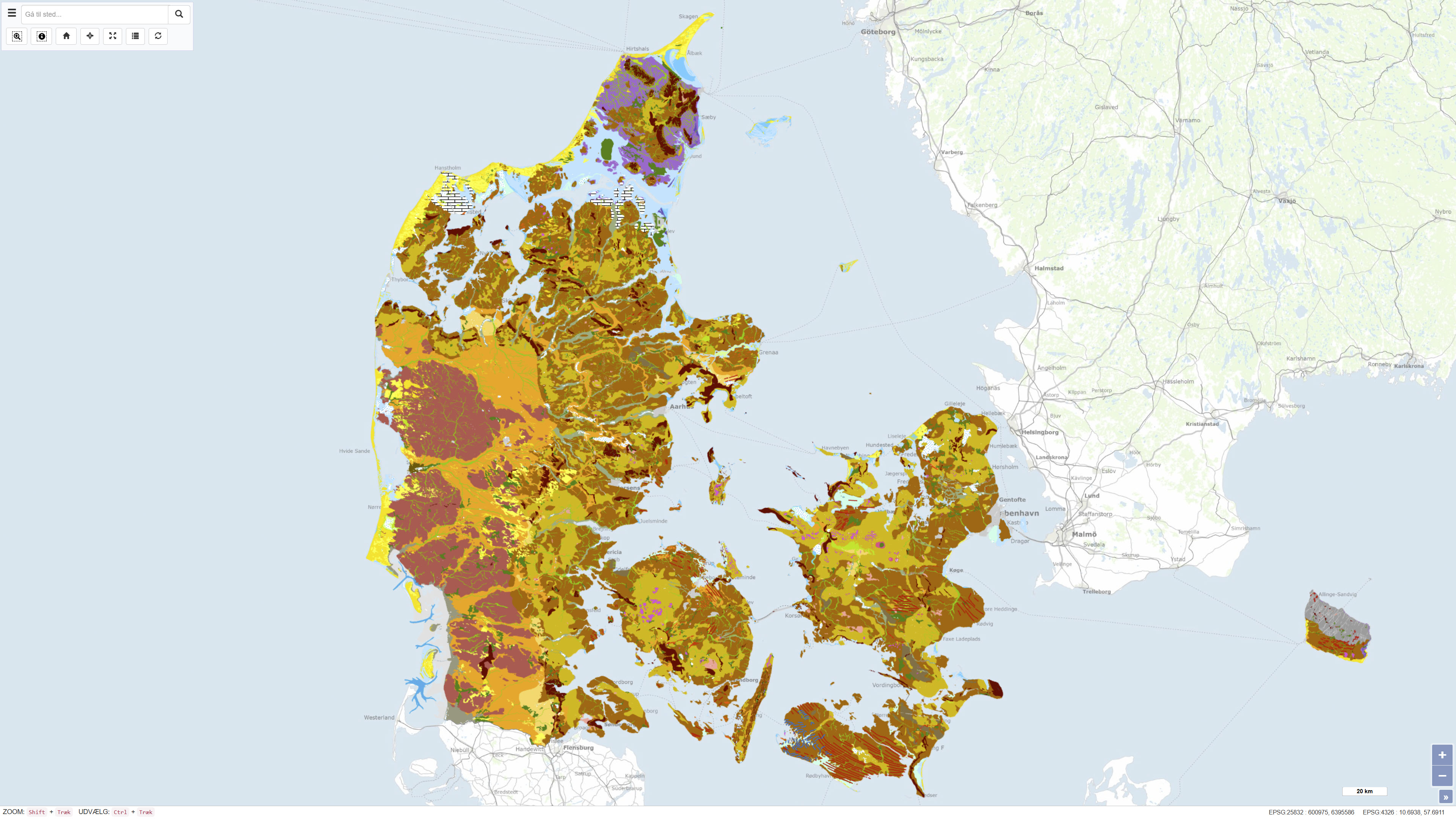
The Geomorphological Map of Denmark, version 3 (2022), depicts landscape types across Denmark at a scale of 1:200.000. The landscape types are defined based on shared geomorphological characteristics that can be related to the processes responsible for their formation. Most landscape types were formed during Quaternary glaciations and by meltwater from the glaciers, while the map also includes post-glacial landscapes such as marine and coastal environments, river valleys, lakes and wetlands, as well as aeolian landforms. The map further reflects landscape features influenced by pre-Quaternary bedrock, including exposed crystalline basement on Bornholm and chalk formations in northern Jutland, as well as surface features related to subsurface structural movements. Anthropogenic landscapes resulting from land reclamation, drainage, excavation, and infilling are also represented. The map is based on systematic geomorphological mapping and interpretation of landforms derived from geological data, terrain analysis and existing cartographic material.
-
This dataset shows the surficial geology points for the Province of Saskatchewan and is designed for the Resource Map of Saskatchewan. This dataset shows the surficial geology points for the Province of Saskatchewan and is designed for the Resource Map of Saskatchewan. Mapping in support of the dataset includes years of field observations which were then compiled and integrated into this dataset. The data was created as a file geodatabase feature class and output for public distribution. 1:1,000,000 scale surficial geology points map of Saskatchewan symbol layer. **Please Note – All published Saskatchewan Geological Survey datasets, including those available through the Saskatchewan Mining and Petroleum GeoAtlas, are sourced from the Enterprise GIS Data Warehouse. They are therefore identical and share the same refresh schedule.
-
This service shows an overview of Sweden's bedrock and soils (meaning unconsolidated deposits) in the scale of 1:1M. The service contains layers showing bedrock lithology, dyke swarms, bedrock structures and unconsolidated deposits (mainly quaternary) covering the whole of Sweden. The information is complied from various surveys and existing maps throughout the country, and is a highly generalised product intended to give an overview on a national level.
-
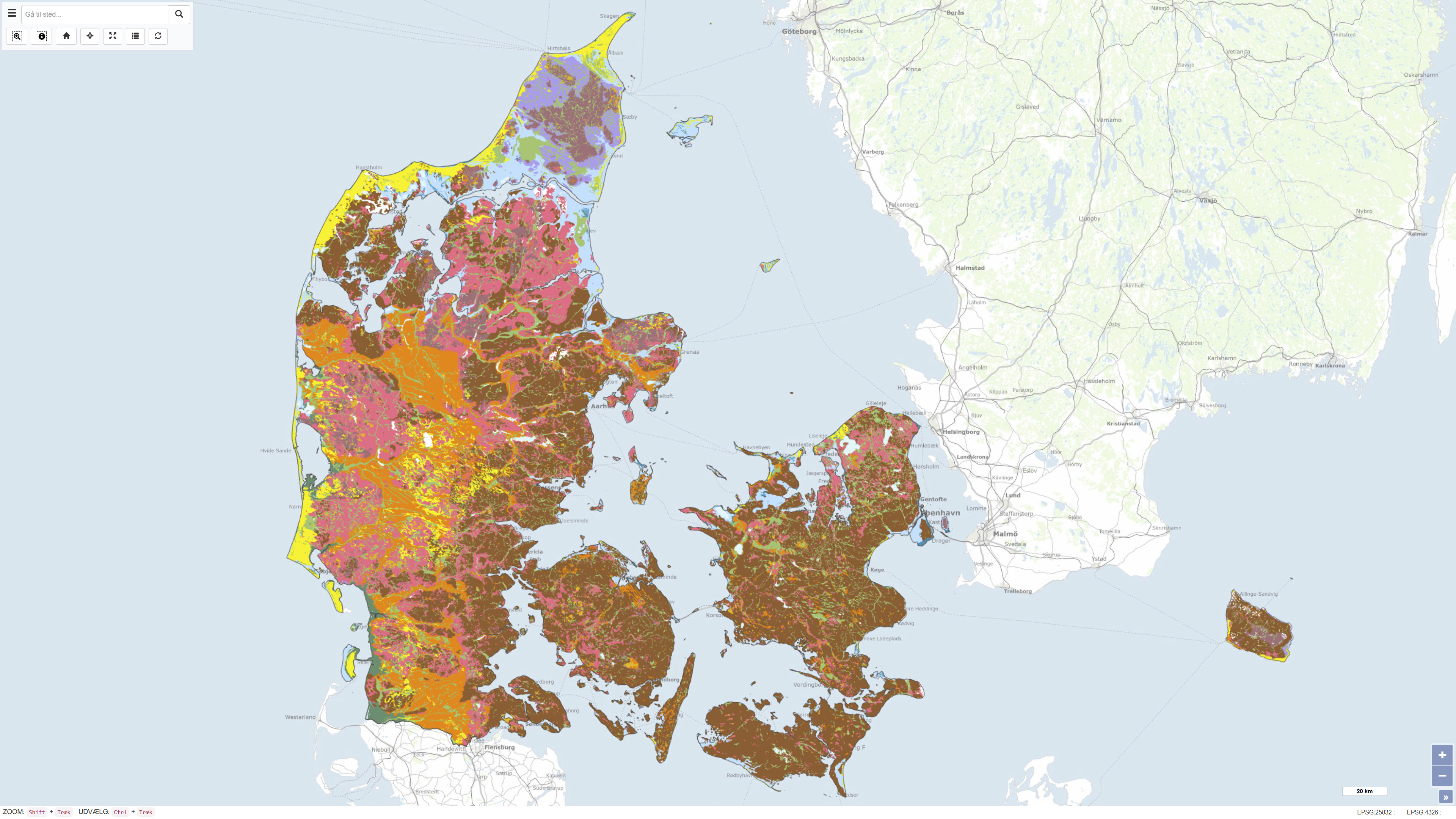
This dataset represents a nationwide digital geological map of superficial deposits in Denmark at a scale of 1:200.000. The map shows the classification and distribution of near-surface deposits, primarily glacial and post-glacial sediments. The dataset is based on the Digital Soil and Sediment Map of Denmark at 1:25.000 in areas where detailed mapping is available. In other areas, the distribution of deposits has been interpreted based on borehole data, landscape analysis and other available geological information. The deposits are classified into 12 generalised types, making the dataset a simplified and generalised version of the detailed 1:25.000 map. The dataset provides a national overview of superficial deposits and serves as a reference for regional and national applications.