 Arctic SDI catalogue
Solar energy
Type of resources
Available actions
Topics
Keywords
Contact for the resource
Provided by
Formats
Representation types
Update frequencies
status
-

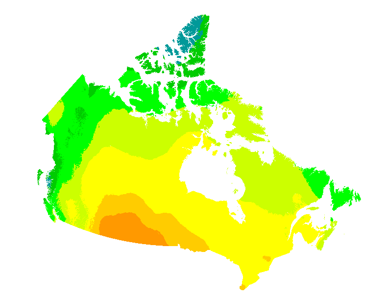
This dataset includes daily averages of solar irradiance on tilted surfaces for all of Canada based on the period of 1998 - 2020. The solar irradiance data is available in the following layers at a resolution of about 0.1°x0.1° (~10 km grid spacing) for all of Canada (i.e., 41.6 to 83.1°N, and 52.6 to 141.0°W): - Four fixed tilts, relative to the horizontal plane, of 0° (horizontal), 30°, 60°, and 90° (vertical) - Three fixed tilts, relative to the local latitude 0°, +15°, and -15° - A two-axis tracking surface For each tilt angle, the irradiance values are in kWh/m2 (per day) for the selected time period. The data can be viewed as a map service and by downloading the tabular data included. Refer to the supporting documentation and dataset for more information.
-
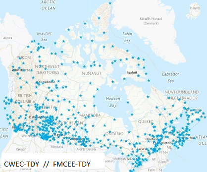
644 datasets of Typical Meteorological Years (TMY) created by joining twelve Typical Meteorological Months selected from a database of up to 20 years of CWEEDS hourly data. The months are chosen by statistically comparing individual monthly means with long-term monthly means for daily total global solar irradiance, mean, minimum and maximum dry bulb temperature, mean, minimum and maximum dew point temperature, and mean and maximum wind speed. These hourly datasets are used by the engineering and scientific community mainly as inputs for solar system design and analysis and building energy systems analysis tools. This dataset has been updated with the most recent changes made in March 2023. The solar values in these files are based on 0.1° x 0.1° (11 km x 11 km grid) for all of Canada. Refer to Data Resources below for additional information on the TMY file format.
-
This web mapping application gives estimates of the electricity that can be generated by grid-connected photovoltaic systems without batteries (in kWh/kWp) and of the mean daily global insolation (in MJ/m2 and in kWh/m2) for any location in Canada on a 60 arc seconds ~2 km grid. They are presented for each month and for the entire year, for six different PV array orientations: a sun-tracking orientation and five fixed South-facing orientations with latitude, vertical (90°), horizontal (0°) and latitude ± 15° tilts. Data can also be obtained directly for individual municipalities from a list of over 3500 municipalities or downloaded for all municipalities at once. These maps and datasets were developed by the Canadian Forest Service (Great Lakes Forestry Centre) in collaboration with the CanmetENERGY Photovoltaic systems group and the Federal Geospatial Platform. Insolation data were provided by Environment and Climate Change Canada. Web map application developed by Federal Geospatial Platform, 2020. References: Pelland S., McKenney D. W., Poissant Y., Morris R., Lawrence K., Campbell K. and Papadopol P., 2006. The Development of Photovoltaic Resource Maps for Canada, In Proceedings of the Annual Conference of the Solar Energy Society of Canada (SESCI) 2006. McKenney D. W., Pelland S., Poissant Y., Morris R., Hutchinson M, Papadopol P., Lawrence K. and Campbell K., 2008. Spatial insolation models for photovoltaic energy in Canada, Solar Energy 82, pp. 1049–1061.
-

Average of the hourly Global Horizontal Irradiance (GHI) over 17 years (1998-2014). Data extracted from the National Solar Radiation Database (NSRDB) developed using the Physical Solar Model (PSM) by National Renewable Energy Laboratory ("NREL"), Alliance for Sustainable Energy, LLC, U.S. Department of Energy ("DOE"). The current version of the National Solar Radiation Database (NSRDB) (v2.0.1) was developed using the Physical Solar Model (PSM), and offers users the solar resource datasets from 1998 to 2014). The NSRDB comprises 30-minute solar and meteorological data for approximately 2 million 0.038-degree latitude by 0.038-degree longitude surface pixels (nominally 4 km2). The area covered is bordered by longitudes 25° W on the east and 175° W on the west, and by latitudes -20° S on the south and 60° N on the north. The solar radiation values represent the resource available to solar energy systems. The AVHRR Pathfinder Atmospheres-Extended (PATMOS-x) model uses half-hourly radiance images in visible and infrared channels from the GOES series of geostationary weather satellites, a climatological albedo database and mixing ratio, temperature and pressure profiles from Modern Era-Retrospective Analysis (MERRA) to generate cloud masking and cloud properties. Cloud properties generated using PATMOS-x are used in fast radiative transfer models along with aerosol optical depth (AOD) and precipitable water vapor (PWV) from ancillary sources to estimate Direct Normal Irradiance (DNI) and Global Horizontal Irradiance (GHI). A daily AOD is retrieved by combining information from the MODIS and MISR satellites and ground-based AERONET stations. Water vapor and other inputs are obtained from MERRA. For clear sky scenes the direct normal irradiance (DNI) and GHI are computed using the REST2 radiative transfer model. For cloud scenes identified by the cloud mask, Fast All-sky Radiation Model for Solar applications (FARMS) is used to compute the GHI. The DNI for cloud scenes is then computed using the DISC model. The data in this layer is an average of the hourly GHI over 17 years (1998-2014). NOTE: The Geographical Information System (GIS) data and maps for solar resources for Global Horizontal Irradiance (GHI) and Direct Normal Irradiance (DNI) were developed by the U.S. National Renewable Energy Laboratory (NREL) and provided for Canada as an estimate. At present, neither the NREL data, nor the Physical Solar Model (PSM) on which the NREL data is based, have been either assessed or validated for the particular Canadian weather applications. A Canadian GHI map developed by the department of Natural Resources Canada (NRCan) is based on the State University of New York (SUNY) model and has been assessed and validated for the particular Canadian weather applications. The Canadian GHI map is available at http://atlas.gc.ca/cerp-rpep/en/.
-

Average of the hourly Direct Normal Irradiance (DNI) over 17 years (1998-2014). Data extracted from the National Solar Radiation Database (NSRDB) developed using the Physical Solar Model (PSM) by National Renewable Energy Laboratory ("NREL"), Alliance for Sustainable Energy, LLC, U.S. Department of Energy ("DOE"). The current version of the National Solar Radiation Database (NSRDB) (v2.0.1) was developed using the Physical Solar Model (PSM), and offers users the solar resource datasets from 1998 to 2014). The NSRDB comprises 30-minute solar and meteorological data for approximately 2 million 0.038-degree latitude by 0.038-degree longitude surface pixels (nominally 4 km2). The area covered is bordered by longitudes 25° W on the east and 175° W on the west, and by latitudes -20° S on the south and 60° N on the north. The solar radiation values represent the resource available to solar energy systems. The AVHRR Pathfinder Atmospheres-Extended (PATMOS-x) model uses half-hourly radiance images in visible and infrared channels from the GOES series of geostationary weather satellites, a climatological albedo database and mixing ratio, temperature and pressure profiles from Modern Era-Retrospective Analysis (MERRA) to generate cloud masking and cloud properties. Cloud properties generated using PATMOS-x are used in fast radiative transfer models along with aerosol optical depth (AOD) and precipitable water vapor (PWV) from ancillary sources to estimate Direct Normal Irradiance (DNI) and Global Horizontal Irradiance (GHI). A daily AOD is retrieved by combining information from the MODIS and MISR satellites and ground-based AERONET stations. Water vapor and other inputs are obtained from MERRA. For clear sky scenes the direct normal irradiance (DNI) and GHI are computed using the REST2 radiative transfer model. For cloud scenes identified by the cloud mask, Fast All-sky Radiation Model for Solar applications (FARMS) is used to compute the GHI. The DNI for cloud scenes is then computed using the DISC model. The data in this layer is an average of the hourly GHI over 17 years (1998-2014). NOTE: The Geographical Information System (GIS) data and maps for solar resources for Global Horizontal Irradiance (GHI) and Direct Normal Irradiance (DNI) were developed by the U.S. National Renewable Energy Laboratory (NREL) and provided for Canada as an estimate. At present, neither the NREL data, nor the Physical Solar Model (PSM) on which the NREL data is based, have been either assessed or validated for the particular Canadian weather applications. A Canadian GHI map developed by the department of Natural Resources Canada (NRCan) is based on the State University of New York (SUNY) model and has been assessed and validated for the particular Canadian weather applications. The Canadian GHI map is available at http://atlas.gc.ca/cerp-rpep/en/.
-

644 datasets of hourly meteorological data for all of Canada from various periods (1998 to 2020). The values of the records for solar irradiance are primarily based on satellite-derived solar estimates. This dataset has been updated with the most recent changes made in March 2023. The solar values in these files are based on 0.1° x 0.1° (11 km x 11 km grid) for all of Canada. Refer to Data Resources below for additional information on the CWEEDS file format and revision history.
-
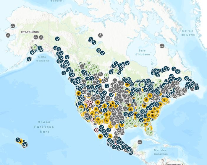
Stations containing prime movers, electric generators, and auxiliary equipment for converting mechanical, chemical into electric energy with an installed capacity of 1 Megawatt or more generated from renewable energy, including biomass, hydroelectric, pumped-storage hydroelectric, geothermal, solar, and wind. Mapping Resources implemented as part of the North American Cooperation on Energy Information (NACEI) between the Department of Energy of the United States of America, the Department of Natural Resources of Canada, and the Ministry of Energy of the United Mexican States. The participating Agencies and Institutions shall not be held liable for improper or incorrect use of the data described and/or contained herein. These data and related graphics, if available, are not legal documents and are not intended to be used as such. The information contained in these data is dynamic and may change over time and may differ from other official information. The Agencies and Institutions participants give no warranty, expressed or implied, as to the accuracy, reliability, or completeness of these data. Parent Collection: [North American Cooperation on Energy Information, Mapping Data](https://open.canada.ca/data/en/dataset/aae6619f-f9f3-435d-bc32-42decd58b674)
-
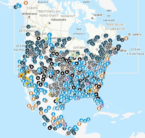
Stations containing prime movers, electric generators, and auxiliary equipment for converting mechanical, chemical, and/or fission energy into electric energy with an installed capacity of 100 megawatts or more. Mapping Resources implemented as part of the North American Cooperation on Energy Information (NACEI) between the Department of Energy of the United States of America, the Department of Natural Resources of Canada, and the Ministry of Energy of the United Mexican States. The participating Agencies and Institutions shall not be held liable for improper or incorrect use of the data described and/or contained herein. These data and related graphics, if available, are not legal documents and are not intended to be used as such. The information contained in these data is dynamic and may change over time and may differ from other official information. The Agencies and Institutions participants give no warranty, expressed or implied, as to the accuracy, reliability, or completeness of these data. Parent Collection: [North American Cooperation on Energy Information, Mapping Data](https://open.canada.ca/data/en/dataset/aae6619f-f9f3-435d-bc32-42decd58b674)
-
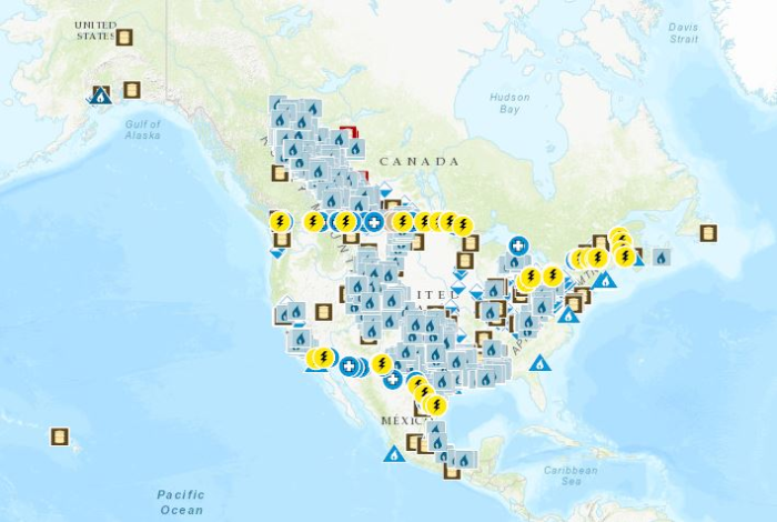
Mapping Resources on energy infrastructure and potential implemented as part of the North American Cooperation on Energy Information (NACEI) between the Department of Energy of the United States of America, the Department of Natural Resources of Canada, and the Ministry of Energy of the United Mexican States. [Natural Gas Processing Plants](https://open.canada.ca/data/en/dataset/636b9550-3700-4e66-8259-5cfc8159a784): Facilities designed to recover natural gas liquids from a stream of natural gas. These facilities control the quality of the natural gas to be marketed. [Refineries](https://open.canada.ca/data/en/dataset/57e7bc4c-680b-4640-9fa1-ded7ce186fab): Facilities that separate and convert crude oil or other feedstock into liquid petroleum products, including upgraders and asphalt refineries. [Liquefied Natural Gas Terminals](https://open.canada.ca/data/en/dataset/e08eec16-7c7a-4253-9bee-ea640d400a54): Natural gas onshore facilities used to receive, unload, load, store, gasify, liquefy, process and transport by ship, natural gas that is imported from a foreign country, exported to a foreign country, or for interior commerce. [Power Plants, 100 MW or more](https://open.canada.ca/data/en/dataset/40fbe40c-01cd-49d3-8add-0d20ed64c90d): Stations containing prime movers, electric generators, and auxiliary equipment for converting mechanical, chemical, and/or fission energy into electric energy with an installed capacity of 100 megawatts or more. [Renewable Power Plants, 1 MW or more](https://open.canada.ca/data/en/dataset/490db619-ab58-4a2a-a245-2376ce1840de): Stations containing prime movers, electric generators, and auxiliary equipment for converting mechanical, chemical into electric energy with an installed capacity of 1 Megawatt or more generated from renewable energy, including biomass, hydroelectric, pumped-storage hydroelectric, geothermal, solar, and wind. [Natural Gas Underground Storage](https://open.canada.ca/data/en/dataset/07b63e0e-09bb-4c4f-b057-63a58d40553a): Sub-surface facilities used for storing natural gas. The facilities are usually hollowed-out salt domes, geological reservoirs (depleted oil or gas field) or water bearing sands (called aquifers) topped by an impermeable cap rock. Border Crossings: [Electric transmission lines](https://open.canada.ca/data/en/dataset/35c51098-5cd8-44b0-b1cd-c8ce2f5dae89), [liquids pipelines](https://open.canada.ca/data/en/dataset/82053097-6b4f-44d9-a750-549df44b36b4) and [gas pipelines](https://open.canada.ca/data/en/dataset/e313db89-4219-4a5e-a543-772a86068710). [Solar Resource, NSRDB PSM Global Horizontal Irradiance (GHI)](https://open.canada.ca/data/en/dataset/9554ed18-6ab2-477f-9545-da091eba762f): Average of the hourly Global Horizontal Irradiance (GHI) over 17 years (1998-2014). Data extracted from the National Solar Radiation Database (NSRDB) developed using the Physical Solar Model (PSM) by National Renewable Energy Laboratory ("NREL"), Alliance for Sustainable Energy, LLC, U.S. Department of Energy ("DOE"). [Solar Resource, NSRDB PSM Direct Normal Irradiance (DNI)](https://open.canada.ca/data/en/dataset/a2dd0554-03f8-4edc-a3b3-67b47c5c9d6d): Average of the hourly Direct Normal Irradiance (DNI) over 17 years (1998-2014). Data extracted from the National Solar Radiation Database (NSRDB) developed using the Physical Solar Model (PSM) by National Renewable Energy Laboratory ("NREL"), Alliance for Sustainable Energy, LLC, U.S. Department of Energy ("DOE"). The participating Agencies and Institutions shall not be held liable for improper or incorrect use of the data described and/or contained herein. These data and related graphics, if available, are not legal documents and are not intended to be used as such. The information contained in these data is dynamic and may change over time and may differ from other official information. The Agencies and Institutions participants give no warranty, expressed or implied, as to the accuracy, reliability, or completeness of these data.