 Arctic SDI catalogue
Wind energy
Type of resources
Available actions
Topics
Keywords
Contact for the resource
Provided by
Formats
Representation types
Update frequencies
status
-

The wind power density layer shows the modeled wind power density [W/m2] at a height of 100 m above ground level, at each grid point, averaged over the three year period from January 1, 2008 to December 31, 2010. Values are presented in bins with ranges of 0.5 W/m2 each. Further details including data at different heights, and for individual years, can be obtained by clicking on the dot representing the grid point location.
-
The Pan-Canadian Wind Integration Study (PCWIS), completed in 2016, assessed the operational and economic implications of integrating large amounts of wind energy into the Canadian electricity system. The PCWIS study generated a significant amount of high-resolution modelled wind data at many locations across Canada. This dataset contains over 54,000 “cells”, with each cell representing one node on a 2×2 km grid. Each cell has an associated time history of three years of modelled wind data, from 2008 to 2010, at 10-minute intervals. The interactive map allows a user to readily visualize the geographic distribution of Canada’s wind resources, as well as to quickly estimate the strength of the wind resource at a particular location.
-

The wind speed layer shows the modeled wind speed [m/s] at a height of 100 m above ground level, at each grid point, averaged over the three year period from January 1, 2008 to December 31, 2010. Values are presented in bins with ranges of 0.5 m/s each. Further details including data at different heights, and for individual years, can be obtained by clicking on the dot representing the grid point location.
-

The maximum temperature layer shows the modeled maximum temperature [°C] at a height of 100 m above ground level, at each grid point, over the three year period from January 1, 2008 to December 31, 2010. Values are presented in bins with ranges of 1.5 °C each. Further details including data for individual years can be obtained by clicking on the dot representing the grid point location.
-

The minimum temperature layer shows the modeled minimum temperature [°C] at a height of 100 m above ground level, at each grid point, over the three year period from January 1, 2008 to December 31, 2010. Values are presented in bins with ranges of 1.5 °C each. Further details including data for individual years can be obtained by clicking on the dot representing the grid point location.
-

Study Area defined in the Agreement to Conduct a Regional Assessment of Offshore Wind Development in Newfoundland and Labrador. The study area was created by the Impact Assessment Agency of Canada in collaboration with Natural Resources Canada and the province of Newfoundland and Labrador.
-

The Canadian Wind Turbine Database contains the geographic location and key technology details for wind turbines installed in Canada. This dataset was jointly compiled by researchers at CanmetENERGY-Ottawa and by the Centre for Applied Business Research in Energy and the Environment at the University of Alberta, under contract from Natural Resources Canada. Additional contributions were made by the Department of Civil & Mineral Engineering at the University of Toronto. Note that total project capacity was sourced from publicly available information, and may not match the sum of individual turbine rated capacity due to de-rating and other factors. The turbine numbering scheme adopted for this database is not intended to match the developer’s asset numbering. This database will be updated in the future. If you are aware of any errors, and would like to provide additional information, or for general inquiries, please use the contact email address listed on this page.
-

Depicts priority area for work under the Regional Assessment of Offshore Wind Development in Newfoundland and Labrador. The Committee for the Regional Assessment of Offshore Wind Development in Newfoundland and Labrador (Committee) is responsible for providing information, knowledge and analysis regarding future offshore wind development (OSW) to inform and improve future planning, licencing and impact assessment processes. The Committee’s mandate is set out in the Agreement to Conduct the Regional Assessment of Offshore Wind Development in Newfoundland and Labrador (Agreement), and includes assessing potential environmental, health, social and economic effects of future OSW. The Agreement includes a broad Study Area. In November 2023, the Committee determined OSW interest in the foreseeable future is more likely within a portion of the Study Area set out in the Agreement. The Committee defined this portion of the Study Area as the assessment's Focus Area. The Committee continues to conduct the Regional Assessment (i.e., present information on existing conditions and consider potential impacts of OSW) within the Focus Area. The Committee's decision to define the Focus Area and supporting rationale is available here: https://iaac-aeic.gc.ca/050/evaluations/document/153431 The Agreement to conduct the Regional Assessment is available here: https://iaac-aeic.gc.ca/050/documents/p84343/147037E.pdf
-

Offshore wind represents a potentially significant source of low-carbon energy for Canada, and ensuring that relevant, high-quality data and scientifically sound analyses are brought forward into decision-making processes will increase the chances of success for any future deployment of offshore wind in Canada. To support this objective, CanmetENERGY-Ottawa (CE-O), a federal laboratory within Natural Resources Canada (NRCan), completed a preliminary analysis of relevant considerations for offshore wind, with an initial focus on Atlantic Canada. To conduct the analysis, CE-O used geographic information system (GIS) software and methods and engaged with multiple federal government departments to acquire relevant data and obtain insights from subject matter experts on the appropriate use of these data in the context of the analysis. The purpose of this work is to support the identification of candidate regions within Atlantic Canada that could become designated offshore wind energy areas in the future. The study area for the analysis included the Gulf of St. Lawrence, the western and southern coasts of the island of Newfoundland, and the coastal waters south of Nova Scotia. Twelve input data layers representing various geophysical, ecological, and ocean use considerations were incorporated as part of a multi-criteria analysis (MCA) approach to evaluate the effects of multiple inputs within a consistent framework. Six scenarios were developed which allow for visualization of a range of outcomes according to the influence weighting applied to the different input layers and the suitability scoring applied within each layer. This preliminary assessment resulted in the identification of several areas which could be candidates for future designated offshore wind areas, including the areas of the Gulf of St. Lawrence north of Prince Edward Island and west of the island of Newfoundland, and areas surrounding Sable Island. This study is subject to several limitations, namely missing and incomplete data, lack of emphasis on temporal and cumulative effects, and the inherent subjectivity of the scoring scheme applied. Further work is necessary to address data gaps and take ecosystem wide impacts into account before deployment of offshore wind projects in Canada’s coastal waters. Despite these limitations, this study and the data compiled in its preparation can aid in identifying promising locations for further review. A description of the methodology used to undertake this study is contained in the accompanying report, available at the following link: https://doi.org/10.4095/331855. This report provides in depth detail into how these data layers were compiled and details any analysis that was done on the data to produce the final data layers in this package.
-
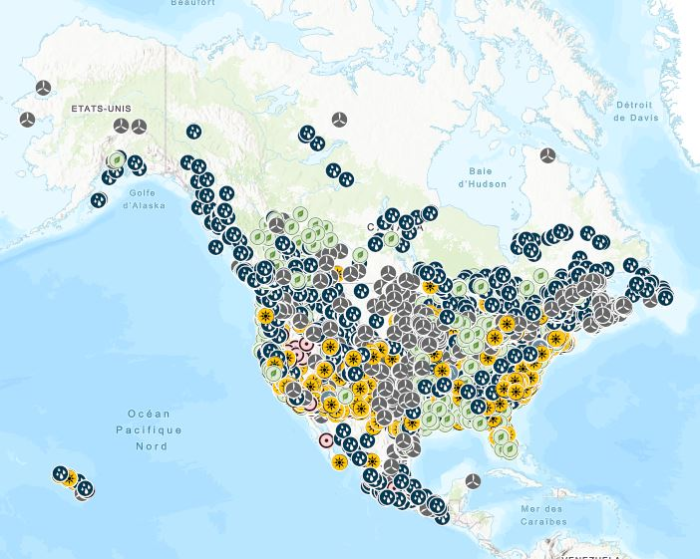
Stations containing prime movers, electric generators, and auxiliary equipment for converting mechanical, chemical into electric energy with an installed capacity of 1 Megawatt or more generated from renewable energy, including biomass, hydroelectric, pumped-storage hydroelectric, geothermal, solar, and wind. Mapping Resources implemented as part of the North American Cooperation on Energy Information (NACEI) between the Department of Energy of the United States of America, the Department of Natural Resources of Canada, and the Ministry of Energy of the United Mexican States. The participating Agencies and Institutions shall not be held liable for improper or incorrect use of the data described and/or contained herein. These data and related graphics, if available, are not legal documents and are not intended to be used as such. The information contained in these data is dynamic and may change over time and may differ from other official information. The Agencies and Institutions participants give no warranty, expressed or implied, as to the accuracy, reliability, or completeness of these data. Parent Collection: [North American Cooperation on Energy Information, Mapping Data](https://open.canada.ca/data/en/dataset/aae6619f-f9f3-435d-bc32-42decd58b674)